H
Field Studies of Mountainous Terrain
The steep slopes and rocky characteristics of mountainous terrain make it difficult to determine interactions of ground water and surface water. Consequently, few detailed hydrogeologic investigations of these interactions have been conducted in mountainous areas. Two examples are given below.
 |
A field and modeling study of the Mirror Lake area in the White Mountains of New Hampshire indicated that the sizes of ground-water flow systems contributing to surface-water bodies were considerably larger than their topographically defined watersheds. For example, much of the ground water in the fractured bedrock that discharges to Mirror Lake passes beneath the local flow system associated with Norris Brook (Figure H-1). Furthermore, a more extensive deep ground-water flow system that discharges to the Pemigewasset River passes beneath flow systems associated with both Norris Brook and Mirror Lake.
Studies in mountainous terrain have used tracers to determine sources of ground water to streams (see Box G). In addition to revealing processes of water exchange between ground water and stream water, solute tracers have proven useful for defining the limits of the hyporheic zone surrounding mountain streams. For example, solute tracers such as chloride or bromide ions are injected into the stream to artificially raise concentrations above natural background concentrations. The locations and amounts of ground-water inflow are determined from a simple dilution model. The extent that tracers move into the hyporheic zone can be estimated by the models and commonly is verified by sampling wells placed in the study area.
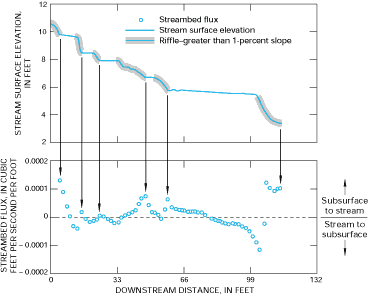
A study in Colorado indicated that hyporheic exchange in mountain streams is caused to a large extent by the irregular topography of the streambed, which creates pools and riffles characteristic of mountain streams. Ground water enters streams most readily at the upstream end of deep pools, and stream water flows into the subsurface beneath and to the side of steep sections of streams (riffles) (Figure H-2). Channel irregularity, therefore, is an important control on the location of ground-water inflow to streams and on the size of the hyporheic zone in mountain streams because changes in slope determine the length and depth of hyporheic flow paths.
Figure H-1: Ground-water flow systems in the Mirror Lake area extend beyond the topographically defined surface-water watersheds. (Modified from Harte, P.T., and Winter, T.C., 1996, Factors affecting recharge to crystalline rock in the Mirror Lake area, Grafton County, New Hampshire: in Morganwalp, D.W., and Aronson, D.A., eds., U.S. Geological Survey Toxic Substances Hydrology Program-- Proceedings of Technical Meeting, Colorado Springs, Colorado, September 20-24, 1993: U.S. Geological Survey Water-Resources Investigations Report 94-4014, p. 141-150.)
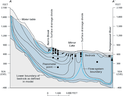
Figure H-2: In mountain streams characterized by pools and riffles, such as at Saint Kevin Gulch in Colorado, inflow of water from the hyporheic zone to the stream was greatest at the downstream end of riffles. (Modified from Harvey, J.W., and Bencala, K.E., 1993, The effect of streambed topography on surface-subsurface water exchange in mountain catchments: Water Resources Research, v. 29, p. 89-98.)
The source and fate of metal contaminants in streams receiving drainage from abandoned mines can be determined by using solute tracers. In addition to surface drainage from mines, a recent study of Chalk Creek in Colorado indicated that contaminants were being brought to the stream by ground-water inflow. The ground water had been contaminated from mining activities in the past and is now a new source of contamination to the stream. This nonpoint ground-water source of contamination will very likely be much more difficult to clean up than the point source of contamination from the mine tunnel.