I
Field Studies of Riverine Terrain
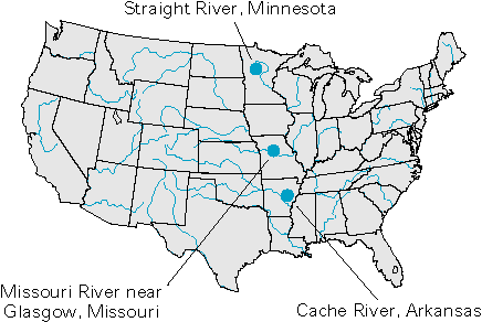
Streams are present in virtually all landscapes, and in some landscapes, they are the principal surface-water features. The interaction of ground water with streams varies in complexity because they vary in size from small streams near headwaters areas to large rivers flowing in large alluvial valleys, and also because streams intersect ground-water flow systems of greatly different scales. Examples of the interaction of ground water and surface water for small and large riverine systems are presented below.
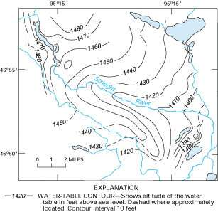
The Straight River, which runs through a sand plain in central Minnesota, is typical of a small stream that does not have a flood plain and that derives most of its water from ground-water inflow. The water-table contours near the river bend sharply upstream (Figure I-1), indicating that ground water moves directly into the river. It is estimated from baseflow studies (see Box B) that, on an annual basis, ground water accounts for more than 90 percent of the water in the river.
 |
In contrast, the results of a study of the lower Missouri River Valley indicate the complexity of ground-water flow and its interaction with streams in large alluvial valleys. Configuration of the water table in this area indicates that ground water flows into the river at right angles in some reaches, and it flows parallel to the river in others (Figure I-2A). This study also resulted in a map that showed patterns of water-table fluctuations with respect to proximity to the river (Figure I-2B). This example shows the wide variety of ground-water flow conditions that can be present in large alluvial valleys.
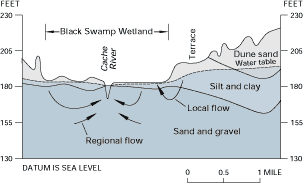
Another study of part of a large alluvial valley provides an example of the presence of smaller scale flow conditions. The Cache River is a stream within the alluvial valley of the Mississippi River Delta system in eastern Arkansas. In a study of the Black Swamp, which lies along a reach of the river, a number of wells and piezometers were installed to determine the interaction of ground water with the swamp and the river. By measuring hydraulic head at different depths in the alluvium, it was possible to construct a hydrologic section through the alluvium (Figure I-3), showing that the river receives ground-water discharge from both local and regional ground-water flow systems. In addition, the section also shows the effect of the break in slope associated with the terrace at the edge of the swamp, which causes ground water from a local flow system to discharge into the edge of the swamp rather than to the river.
Figure I-1: Small streams, such as the Straight River in Minnesota, commonly do not have flood plains. The flow of ground water directly into the river is indicated by the water-table contours that bend sharply upstream. (Modified from Stark, J.R., Armstrong, D.S., and Zwilling, D.R., 1994, Stream-aquifer interactions in the Straight River area, Becker and Hubbard Counties, Minnesota: U.S. Geological Survey Water-Resources Investigations Report 94-4009, 83 p.)
Figure I-2: In flood plains of large rivers, such as the Missouri River near Glasgow, Missouri, patterns of ground-water movement (A) and water-table fluctuations (B) can be complex. Zone I is an area of rapidly fluctuating water levels, zone II is an area of long-term stability, zone III is an area of down-valley flow, and zone IV is a persistent ground-water high. (Modified from Grannemann, N.G., and Sharp, J.M., Jr., 1979, Alluvial hydrogeology of the lower Missouri River: Journal of Hydrology, v. 40, p. 85-99.) (Reprinted with permission from Elsevier Science-NL, Amsterdam, The Netherlands.)
Figure I-3: The Cache River in Arkansas provides an example of contributions to a river from regional and local ground-water flow systems. In addition, a small local ground-water flow system associated with a terrace discharges to the wetland at the edge of the flood plain. (Modified from Gonthier, G.J., 1996, Ground-water flow conditions within a bottomland hardwood wetland, eastern Arkansas: Wetlands, v. 16, no. 3, p. 334-346.) (Used with permission.)


