J
Field Studies of Coastal Terrain
Along the Atlantic, Gulf of Mexico, and Arctic Coasts of the United States, broad coastal plains are transected by streams, scarps, and terraces. In some parts of these regions, local ground-water flow systems are associated with scarps and terraces, and freshwater wetlands commonly are present. Other parts of coastal regions are affected by tides, resulting in very complex flow and biogeochemical processes.
Underlying the broad coastal plain of the mid-Atlantic United States are sediments 600 or more feet thick. The sands and clays were deposited in stratigraphic layers that slope gently from west to east. Ground water moves regionally toward the east in the more permeable sand layers. These aquifers are separated by discontinuous layers of clay that restrict vertical ground-water movement. Near land surface, local ground-water flow systems are associated with changes in land slope, such as at major scarps and at streams.
 |
Studies of the Dismal Swamp in Virginia and North Carolina provide examples of the interaction of ground water and wetlands near a coastal scarp. The Suffolk Scarp borders the west side of Great Dismal Swamp. Water-table wells and deeper piezometers placed across the scarp indicated a downward component of ground-water flow in the upland and an upward component of ground-water flow in the lowland at the edge of the swamp (Figure J-1A). However, at the edge of the swamp the direction of flow changed several times between May and October in 1982 because transpiration of ground water lowered the water table below the water level of the deep piezometer (Figure J-1B).
The gentle relief and sandy, well-drained soils of coastal terrain are ideal for agriculture. Movement of excess nutrients to estuaries are a particular problem in coastal areas because the slow rate of flushing of coastal bays and estuaries can cause them to retain nutrients. At high concentrations, nutrients can cause increased algal production, which results in overabundance of organic matter. This, in turn, can lead to reduction of dissolved oxygen in surface water to the extent that organisms are killed throughout large areas of estuaries and coastal bays.
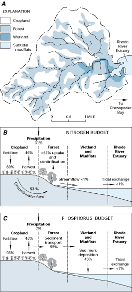
Movement of nutrients from agricultural fields has been documented for the Rhode River watershed in Maryland (Figure J-2). Application of fertilizer accounts for 69 percent of nitrogen and 93 percent of phosphorus input to this watershed (Figure J-2B and J-2C). Almost all of the nitrogen that is not removed by harvested crops is transported in ground water and is taken up by trees in riparian forests and wetlands or is denitrified to nitrogen gas in ground water before it reaches streams. On the other hand, most of the phosphorus not removed by harvested crops is attached to soil particles and is transported only during heavy precipitation when sediment from fields is transported into streams and deposited in wetlands and subtidal mudflats at the head of the Rhode River estuary. Whether phosphorus is retained in sediments or is released to the water column depends in part on whether sediments are exposed to oxygen. Thus, the uptake of nutrients and their storage in riparian forests, wetlands, and subtidal mudflats in the Rhode River watershed has helped maintain relatively good water quality in the Rhode River estuary.
In other areas, however, agricultural runoff and input of nutrients have overwhelmed coastal systems, such as in the northern Gulf of Mexico near the mouth of the Mississippi River. The 1993 flood in the Mississippi River system delivered an enormous amount of nutrients to the Gulf of Mexico. Following the flood, oxygen-deficient sediments created areas of black sediment devoid of animal life in parts of the northern Gulf of Mexico.
Figure J-1: Ground-water discharge at the edge of the Great Dismal Swamp in Virginia provides an example of local ground-water flow systems associated with coastal scarps (A). The vertical components of flow can change direction seasonally, partly because evapotranspiration discharges shallower ground water during part of the year (B). (Modified from Carter, Virginia, 1990, The Great Dismal Swamp-An illustrated case study, chapter 8, in Lugo, A.E., Brinson, Mark, and Brown, Sandra, eds., Ecosystems of the world, 15: Forested wetlands, Elsevier, Amsterdam, p. 201-211.) (Reprinted with permission from Elsevier Science-NL, Amsterdam, The Netherlands.)
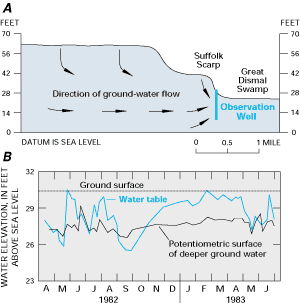
Figure J-2: Forests and wetlands separate cropland from streams in the Rhode River watershed in Maryland (A). More than half of the nitrogen applied to cropland is transported by ground water toward riparian forests and wetlands (B). More than half of the total phosphorus applied to cropland is transported by streams to wetlands and mudflats, where most is deposited in sediments (C). (Modified from Correll, D.L., Jordan, T.E., and Weller, D.E., 1992, Nutrient flux in a landscape-Effects of coastal land use and terrestrial community mosaic on nutrient transport to coastal waters: Estuaries, v. 15, no. 4, p. 431-442.) (Reprinted by permission of the Estuarine Research Federation.)