N
Effects of Irrigation Development on the Interaction of Ground Water and Surface Water
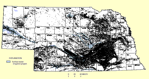
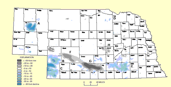
Nebraska ranks second among the States with respect to the area of irrigated acreage and the quantity of water used for irrigation. The irrigation water is derived from extensive supply systems that use both surface water and ground water (Figure N-1). Hydrologic conditions in different parts of Nebraska provide a number of examples of the broad-scale effects of irrigation development on the interactions of ground water and surface water. As would be expected, irrigation systems based on surface water are always located near streams. In general, these streams are perennial and (or) have significant flow for at least part of the year. In contrast, irrigation systems based on ground water can be located nearly anywhere that has an adequate ground-water resource. Areas of significant rise and decline in ground-water levels due to irrigation systems are shown in Figure N-2. Ground-water levels rise in some areas irrigated with surface water and decline in some areas irrigated with ground water. Rises in ground-water levels near streams result in increased ground-water inflow to gaining streams or decreased flow from the stream to ground water for losing streams. In some areas, it is possible that a stream that was losing water before development of irrigation could become a gaining stream following irrigation. This effect of surface-water irrigation probably caused the rises in ground-water levels in areas F and G in south-central Nebraska (Figure N-2).
Average annual precipitation ranges from less than 15 inches in western Nebraska to more than 30 inches in eastern Nebraska. A large concentration of irrigation wells is present in area E (Figure N-2). The ground-water withdrawals by these wells caused declines in ground-water levels that could not be offset by recharge from precipitation and the presence of nearby flowing streams. In this area, the withdrawals cause decreases in ground-water discharge to the streams and (or) induce flow from the streams to shallow ground water. In contrast, the density of irrigation wells in areas A, B, and C is less than in area E, but water-level declines in these three western areas are similar to area E. The similar decline caused by fewer wells in the west compared to the east is related to less precipitation, less ground-water recharge, and less streamflow available for seepage to ground water.
Figure N-1:Nebraska is one of the most extensively irrigated States in the Nation. The irrigation water comes from both ground-water and surface-water sources. Dots are irrigation wells. (Map provided by the University of Nebraska, Conservation and Survey Division.)
Figure N-2: The use of both ground water and surface water for irrigation in Nebraska has resulted in significant rises and declines of ground-water levels in different parts of the State. (Map provided by the University of Nebraska, Conservation and Survey Division.)

