![]()
Ground-water/surface-water interactions affect water quality in the Suwannee River. | |
|
Resource managers are concerned that nitrate in ground water increases nitrate concentrations and loads in the lower Suwannee River (Ceryak and Hornsby, 1996), a stream reach that is highly valued for ecological and recreational reasons. Nitrate concentrations in the lower Suwannee River are affected by a cycle of water exchange between the river and the Upper Floridan aquifer. The greatest amount of ground-water inflow to the Suwannee River occurs during low flow when ground-water discharges to the river through springs and upward movement of ground water through the riverbed (riverbed leakage). The greatest amount of river-water inflow to the Upper Floridan aquifer occurs during high flow when water from the Suwannee River recharges portions of the aquifer. |
|
 (37,873 bytes)
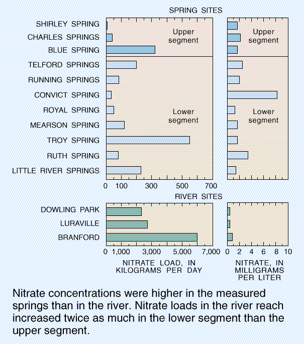
Nitrate concentrations were higher in the measured springs than in the river. Nitrate loads in the river reach increased twice as much in the lower segment than the upper segment.
Several springs are present along the river reach from Dowling Park to Branford, Fla. This 33-mile reach, which was divided into an upper and lower segment, was selected because all the inflow to the river is from ground water. During low flow in July 1995, the river and 11 springs were measured and sampled (Pittman and others, 1997).
River discharge increased by 950 cubic feet per second (ft3/s) along the entire study reach. Inflow from springs that were measured accounted for about 40 percent of the increase, and inflow from other ground water such as unmeasured springs and riverbed leakage accounted for about 60 percent.
Nitrate concentrations in the measured springs ranged from 1.3 to 8.2 mg/L; the median concentration was 1.7 mg/L. Nitrate concentrations at the three river sites were less than 1.0 mg/L and almost doubled in the lower segment. Except for Convict Spring, a spring with a small discharge (1.7 ft3/s), the nitrate concentrations of springs in the upper and lower segments were similar.
In the upper segment, the estimated nitrate concentration for other ground water (unmeasured springs and riverbed leakage) was 0.05 mg/L, which is much lower than the concentration in measured springs. In contrast, in the lower segment, the estimated nitrate concentration for other ground-water inflow was 2.7 mg/L, which is similar to concentrations for measured springs.
The nitrate load increased 3,700 kilograms per day (kg/d) in the river reach. Eleven percent of the increase occurred in the upper segment; the remaining 89 percent occurred in the lower segment. Measured springs were the major contributor to the nitrate load in the upper reach and other ground-water inflow was the major contributor in the lower reach. The spring contributing the largest load was Troy Spring, the spring with the largest discharge (132 ft3/s).
Possible sources of nitrate in the ground water in the vicinity of the river reach include fertilizer, animal wastes from dairy and poultry operations, and septic-tank effluent. The differences between the two river segments indicate that increases in nitrate loads in the river reach are controlled by factors that interact with the effects of land use on ground water. These factors include magnitude of spring discharges, the size and location of the spring basins, and ground-water hydrology.
 (22,791 bytes)
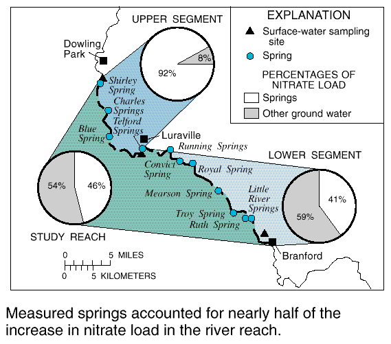
Measured springs accounted for nearly half of the increase in nitrate load in the river reach.
During high flow, stream water infiltrated the aquifer and caused a decrease in nitrate concentrations. Field observations indicated that the Suwannee River flooded the Little River Springs. During this flooding, river water levels rose about 10 ft above the base-flow level of the spring; thus, river water was likely inflowing to the spring during this period. The Little River Springs, ground water in the vicinity of the spring, and the Suwannee River (upstream and downstream from the spring) were sampled four times from July 1995 through April, 1996 (C.A. Crandall, U.S. Geological Survey, written commun., 1997).
High flow on the Suwannee River near Little River Springs peaked at 12,700 ft3/s in April 1996. Water levels in the river and the aquifer gained 10 feet in elevation, and a low in the water table formed in the Upper Floridan aquifer, approximately 1 mile from the river. This low area indicates that surface water may have moved laterally into the aquifer, causing ground-water flow to be slowed and redirected. Thus the necessary time and chemical conditions [high dissolved organic carbon (DOC) and low dissolved oxygen concentrations] were favorable for denitrification to occur.
 (10,561 bytes)
A low formed in the water table north of the Little River Springs during high flow conditions in 1996.
Denitrification can occur when river water containing DOC flows into the Upper Floridan aquifer (Katz and Dehan, 1996). Denitrification is a naturally occurring microbial process that decreases nitrate concentrations in water.
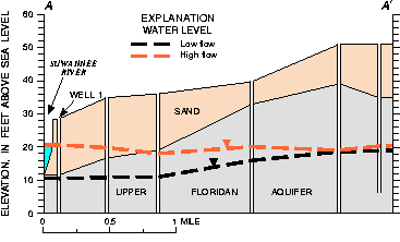
Water levels were 10 feet higher during high flow conditions on the river (April 10, 1996).
| Water sampled | Nitrate as N, mg/L | DOC, mg/L | ||
|---|---|---|---|---|
| Low flow | High flow | Low flow | High flow | |
| Well 1 | 0.18 | 0.05 | 1.0 | 28 |
| Little River Springs | 1.25 | 0.08 | 0.55 | 31 |
| Suwannee River | 0.77 | 0.10 | 12 | 30 |
The chemical effects of stream water recharging ground water during high flow were noted in water from well 1, located about 300 feet from the river channel. A geochemical mixing model (Parkhurst, 1995) gave an estimate of 88 percent river water in this well. The DOC concentration increased from 1.0 mg/L during low flow to 28 mg/L during high flow. Over the same period, the nitrate concentration decreased from 0.18 to 0.05 mg/L. Denitrification is a likely explanation for the decrease in nitrate concentrations in this well. If denitrification occurs in the aquifer during high flow, then nitrate loads from ground water will be decreased when ground water flows into the river.
 (191,812 bytes)
Last modified: April 14, 1998 10:45 am