![]()
Water Quality in the Western Lake Michigan Drainages, Wisconsin and Michigan, 1992-95
Table of contents || Previous section || Next section || Glossary
STREAM CHEMISTRY |
|
 (13,602 bytes)
 |
Fixed Sites were established to examine differences in stream-water quality due to the environmental setting (land use, surficial deposits, and bedrock type) of the study area. Intensive Fixed Sites were sampled more frequently to determine seasonal variability in water quality and to test for 88 pesticides. Synoptic studies focused on sampling high and low flows to characterize concentration and spatial distribution of nutrients, pesticides, sediment, and other water-quality characteristics. Streambed sediments, aquatic insects, and fish tissue were analyzed for trace elements and organic compounds. |
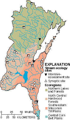
STREAM ECOLOGY |
|
|---|---|
 (11,344 bytes)
 |
Intensive ecological assessments were done at the 11 Fixed Sites to define existing biological conditions to which future monitoring results will be compared and to assess temporal variations. Synoptic studies were designed to evaluate the spatial distribution of aquatic biological community structure. |
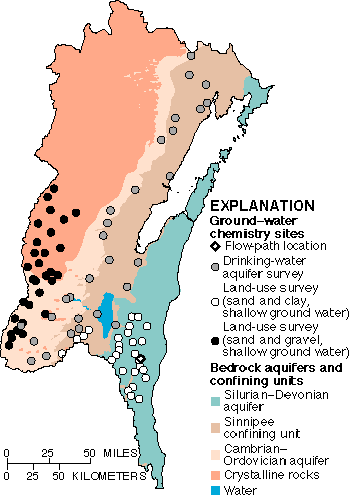
GROUND-WATER CHEMISTRY |
|
|---|---|
 (10,600 bytes)
 |
To evaluate the effects of agricultural land use and surficial deposits on shallow ground-water quality, one aquifer overlain by sand and clay and the other by sand and gravel were studied. A drinking-water aquifer survey assessed the water-quality in the most heavily used aquifer in the Study Unit. A study in an agricultural area was designed to determine changes in nutrient and pesticide concentrations along shallow ground-water flow paths. |
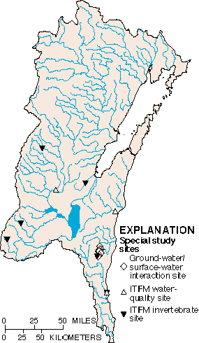
SPECIAL STUDIES |
|
|---|---|
 (8,819 bytes)
 |
Additional studies provided important information on the water resources of the study area. The interaction between ground water and surface water was investigated using water-chemistry data. A comparison of water-quality sample collection, preservation, shipping, and laboratory techniques of the USGS and the Wisconsin Department of Natural Resources (WDNR) were studied to determine comparability of water-chemistry results. Differences in macroinvertebrate-collection techniques of three agencies were investigated to evaluate comparability of results. |
| Study
component |
What data were collected and why | Types of sites sampled | Number of sites | Sampling frequency and period |
|---|---|---|---|---|
| Stream Chemistry | ||||
| Fixed Sites
-- general water chemistry |
Streamflow was measured continuously and samples were collected monthly for major ions, nutrients, organic carbon, suspended sediment, and physical properties to describe concentration, seasonal variability, and loads. | 11 | Monthly plus storms;
April 1993-July 1995 |
|
| Intensive Fixed Sites
-- pesticides |
In addition to the above constituents, samples were analyzed for 88 dissolved pesticides to describe concentration and seasonal variations. | A subset of Fixed Sites draining agricultural and urban land-use areas. | 3 | Monthly during growing
season; 20 per year, 1993-94 |
| Synoptic sites
-- water chemistry |
Streamflow, nutrients, pesticides, suspended sediments, and physical
properties were determined for high- and(or) low-flow conditions to describe
concentrations and
spatial distributions. |
Streams draining basins ranging in size from 2 to 6,332 square miles and representing forested, agricultural, urban, and mixed land uses. | 145 total
42 high flow 59 low flow 95 low flow |
Spring and summer 1994,
summer 1994 July 1995 |
| Contaminants
-- streambed sediments |
Streambed sediments were analyzed for trace elements and hydrophobic pesticides and other organic compounds to determine occurrence and spatial distribution. | Depositional zones at all Fixed Sites and numerous synoptic sites. | 31 | 6-9 Fixed Sites in 1992(6), 1994(8), 1995(9); 7-12 synoptic sites in 1992(12), 1995(7) |
| Contaminants
-- aquatic biota |
Trace elements in fish livers and organic compounds in whole insects and whole fish were sampled and analyzed to determine occurrence and spatial distribution. | All Fixed Sites and some synoptic sites. | 25 | 4-8 Fixed Sites in 1992(4), 1994(8), 1995(7); 6-7 synoptic sites in 1992(7), 1995(6) |
| Stream Ecology | ||||
| Intensive
assessments |
Fish, benthic invertebrates, algae, and aquatic and riparian habitats were sampled and described to assess aquatic biological community structure in different land uses and associated habitats. | Stream reaches collocated with Fixed Sites. Sites represent the variety of land uses, bedrock geology, and surficial texture within the basin. | 11 | 8 Indicator Sites annually, 1993-95; three reaches sampled at 3 sites; 3 Integrator Sites, 1995 |
| Synoptic studies | Fish, benthic invertebrates, algae, and aquatic and riparian habitats were described to assess spatial distribution of aquatic biological community structure of relatively pristine streams in an agricultural setting. | Benchmark stream reaches chosen to represent relatively pristine conditions in agricultural areas. Comparison sites determine variability within RHUs. | 34 | 20 Benchmark sites, once in spring/summer 1993 and 1995; 12 RHU Comparison sites, 1993 |
| Ground-Water Chemistry | ||||
| Land-use effects
-- sand and clay -- shallow ground water |
Major ions, nutrients, pesticides, volatile organic compounds (VOCs), tritium, dissolved organic carbon (DOC), chlorofluorocarbons (CFCs) and isotopes of oxygen, hydrogen, and uranium were sampled and analyzed for to determine effects of agriculture on the quality of recently recharged ground water in the alluvial aquifer. | Newly installed monitoring wells completed at water table located using
a
statistically random selection process. Predominantly agricultural land use (80%): corn and alfalfa are the main crops. |
26 wells, 2 springs | Once in September 1993 and summer 1994 |
| Land-use effects
-- sand and gravel -- shallow ground water |
Major ions, nutrients, pesticides, VOCs, tritium, DOC, CFCs, and isotopes of oxygen, hydrogen, and uranium were sampled and analyzed for to determine effects of agriculture on the quality of recently recharged ground water in the alluvial aquifer. | Sites with monitoring wells completed at water table chosen using a statistically random selection process. Predominantly agricultural land use (48%): corn and alfalfa are the main crops. | 30 | Once in September 1994 |
| Drinking-water survey
-- sandstone |
Major ions, nutrients, pesticides, VOCs, radon, tritium, and DOC were sampled and analyzed for to assess the condition of ground-water quality in the most used aquifer in the study area (40% of ground-water use). | Existing domestic, institutional, or public supply wells completed in bedrock (<900 ft.) chosen using a statistically random selection process. | 29 | Once in June and August 1995 |
| Flow path | Major ions, nutrients, pesticides, tritium, DOC, CFCs and isotopes of oxygen, hydrogen, and nitrogen and gas composition were sampled and analyzed to determine changes in nutrients and pesticides along a flow path. | Clusters of wells, lysimeters, and minipiezometers along an approximate line of a ground-water flow path (2,500 ft) in an agricultural area in Sheboygan County. | 10 wells, 8 lysimeters, 8 minipiezometers, stream | 1-3 times each in June 1994, May 1995, and August 1995 |
| Special Studies | ||||
| Ground-water/
surface-water interactions |
Major ions, nutrients, pesticides, and oxygen and hydrogen isotopes were analyzed to study ground-water/surface-water interaction in the vicinity of the flowpath study area. | Tributaries to North Branch Milwaukee River and shallow ground- water samples from three cross sections from the North Branch Milwaukee River. | 10 tributaries,
12 minipiezometers |
Once in August 1993 |
| ITFM
--water quality |
Total phosphorus, dissolved chloride, and suspended sediment were determined to compare water-quality collection, preservation, shipping, and laboratory techniques used by the USGS and WDNR. | Rivers under low-flow and high-flow conditions. | 3 | August 1993-July 1994; 4 times each (2 low flow and 2 high flow) |
| ITFM
--Benthic invertebrates |
Benthic-invertebrate community structure in riffles was assessed to determine if various sampling methods predict water quality similarly. | Streams ranging in drainage area from 15 to 696 square miles, from cold to warm water, draining different land uses. | 6 | Once in May 1995 |
U.S. Geological Survey Circular 1156
Table of contents || Previous section || Next section || Glossary
Suggested citation:
C. A. Peters, D. M. Robertson, D. A. Saad, D. J. Sullivan, B. C. Scudder,
F. A. Fitzpatrick, K. D. Richards, J. S. Stewart, S. A. Fitzgerald, and
B. N. Lenz, 1998, U.S. Geological Survey Circular 1156, on line at <URL:
http://water.usgs.gov/pubs/circ1156>, updated June 11, 1998
This page is a subpage of URL: <http://water.usgs.gov/pubs/circ1156
Email questions and comments to GS-W_NAWQA_Outreach@usgs.gov
Last modified: Wed Jul 8 14:03:33 1998