![]()
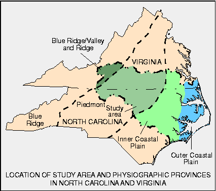
The Albemarle-Pamlico Drainage Basin, located in North Carolina and Virginia, drains an area of about 28,000 square miles (mi2) (fig. 1). Four physiographic regions--the Valley and Ridge, Blue Ridge, Piedmont, and Coastal Plain Provinces--are included within the Albemarle-Pamlico Drainage area. For this study, the Coastal Plain was further divided into the inner Coastal Plain and the outer Coastal Plain (Harned and others, 1995).
Figure 1. Four major rivers--the Chowan, Roanoke, Tar, and Neuse--drain into the Albemarle and Pamlico Sounds in North Carolina.
Water quality in the Albemarle-Pamlico Drainage area is affected by natural and cultural factors. Major factors include physiography, soils, geology, precipitation, and land use and are similar within each physiographic province.
The physiography, geology, and soils form the container over and through which surface and ground water flow. In the mountains where slopes are steep, surface water and shallow ground water move fast and have less opportunity to dissolve rock and soil or undergo other geochemical processes, such as ion exchange or adsorption; consequently, the water generally contains very little dissolved mineral matter. In the Piedmont and Coastal Plain, slopes are gentler and water moves more slowly; consequently, surface water there generally has two to three times the mineral content of surface and ground waters in the mountains. Different rock types and the associated soils also influence the nature and amount of minerals dissolved in the waters.
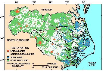
Land use, population distribution, and manmade reservoirs have significant effects on water quality in the study area. In general, the study area is dominated by a patchwork of forested (50 percent of the area) and agricultural (more than 30 percent) lands, with large tracts of wetlands (about 15 percent) in the eastern Coastal Plain (fig. 2). Less than 5 percent of the overall basin area contains urban land. The principal agriculture in the basin includes corn, soybean, cotton, peanut, tobacco, grain, and potato cultivation and chicken, turkey, hog, and cattle production. Agricultural and urban land uses have the greatest potential to affect water quality because these land uses are the sources of large amounts of nutrients, sediments, and pesticides.
Figure 2. Forested and agricultural lands dominate the study area with extensive wetlands in the eastern part.
Average annual precipitation ranges from 36 inches in the western part of the Albemarle-Pamlico Drainage Basin to 52 inches in the eastern part of the basin (McMahon and Lloyd, 1995). This water leaves the basin by way of streams and ground water.
In general, more than one-half of the water flowing in streams discharging to the Albemarle-Pamlico Drainage Basin comes from ground water. Thus, the quality of ground water has substantial influence on surface-water quality. Major aquifers in the Valley and Ridge, Blue Ridge, and Piedmont Provinces are fractured rocks overlain by uncon- solidated regolith; in the Coastal Plain Province, aquifers are primarily unconsolidated and partly consolidated sands with some limestone and sandy limestone.
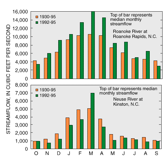
Streamflow in the Roanoke River at Roanoke Rapids, N.C., was higher during the study period, 1992-95, than during the long-term period of record (1930-95) (fig. 3). Higher streamflows tend to exacerbate nonpoint surface-runoff pollution and dilute point-source pollution. Except during March, streamflow in the Neuse River at Kinston, N.C., was slightly lower during the study period than during the long-term period of record (1930-95) (fig. 3). Lower streamflows tend to exacerbate point-source pollution and diminish nonpoint surface-runoff pollution.
Figure 3. Streamflow was higher in the Roanoke River during the study period than during the long-term period of record, and except during March, streamflow was slightly lower in the Neuse River during the study period than during the long-term period of record.
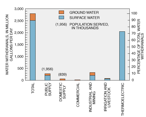
Average water use during 1990 in the Albemarle-Pamlico Drainage Basin was about 2,800 million gallons per day (Mgal/d) (McMahon and Lloyd, 1995). Most of this water is from surface water (90 percent) with the remaining 10 percent supplied from ground water (fig. 4). About 3 million people live in the basin, and 11 percent of all water used is for public or domestic drinking water. Two-thirds of this population obtains water from public water-supply sources, most of which (75 percent) is from surface water; the remaining one-third of the population uses ground water supplied by private domestic wells).
Figure 4. Surface water is used most in the study area, and the generation of thermoelectric power uses the most water.
 (57,942 bytes)
Canoeing in Contentnea Creek, North Carolina