![]()
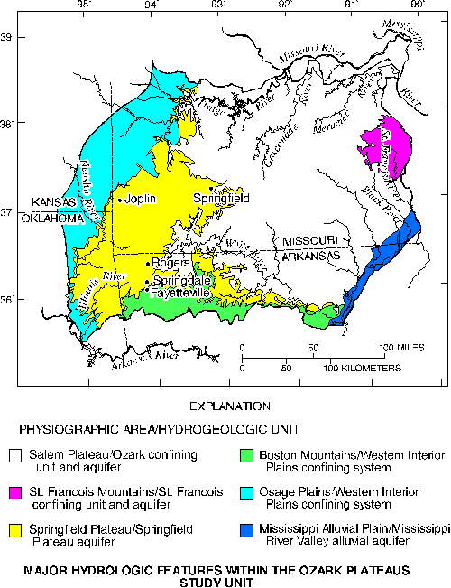
Several river systems drain the Study Unit. Most drain radially away from south-central Missouri or northward from the Boston Mountains. Aquifers in the Study Unit generally coincide with the physiographic areas (Fenneman, 1938), but the extensive Springfield Plateau and Ozark aquifers also dip beneath other aquifers or confining units in physiographic areas to the west and south.
|
Major hydrologic features within the Ozark Plateaus Study Unit |
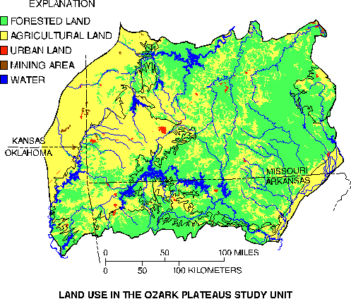
Land use in the Ozark Plateaus Study Unit |
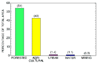
Land use is almost equally divided between forested and agricultural land, but is not distributed evenly across the Study Unit (Adamski and others, 1995). The Salem Plateau, Boston Mountains, and St. Francois Mountains are primarily forested, while agricultural land is most common in other areas. Most of the agricultural land in the Salem and Springfield Plateaus and in the Boston Mountains is pastureland associated with production of poultry and cattle. Lead and zinc mining occurs or has occurred in some areas. Large urban areas are not common. Only the five cities on the map above have populations exceeding 20,000 (U.S. Department of Commerce, 1990). These land uses affect the physical, chemical, and biological properties of the water and land.
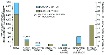
Approximately 50 percent of the water use in the Study Unit is surface water used (nonconsumptively) for thermoelectric cooling. Almost 25 percent of the water use is for irrigation and livestock; most of this water is ground water used for irrigation in the Mississippi Alluvial Plain. Most of the remaining water use is for public and domestic supplies (drinking and related water uses). About 30 percent of the 2.1 million people in the Study Unit get their drinking water from relatively shallow domestic wells.
|
Estimated land use |
Estimated water withdrawals in 1990 |
Streamflow is an important factor affecting water quality. During wet-weather periods, runoff carries materials into the stream from the land; concentrations of nutrients, bacteria, pesticides, and sediment can be elevated above the more typical concentrations for that stream. Higher streamflows can dilute concentrations of materials in streams if the source of the materials is not runoff. For example, nutrient concentrations in a stream affected primarily by a wastewater-treatment plant usually decrease during wet-weather periods. During dry periods, concentrations of materials contributed by runoff are lower, while concentrations of materials from wastewater-treatment plants or other similar sources usually are higher because of less water for dilution.
Shallow ground water can also be affected similarly by periods of wet or dry weather. The extent to which ground water is affected depends on the hydrologic connection between the land surface and ground water; this is affected by factors such as local soils and geology. Karst features (springs, seeps, sinkholes, and caves) are abundant in much of the Springfield and Salem Plateaus. These features allow rapid movement of ground water and substantial movement of water between the surface-water and ground-water environments.
 (14,427 bytes)
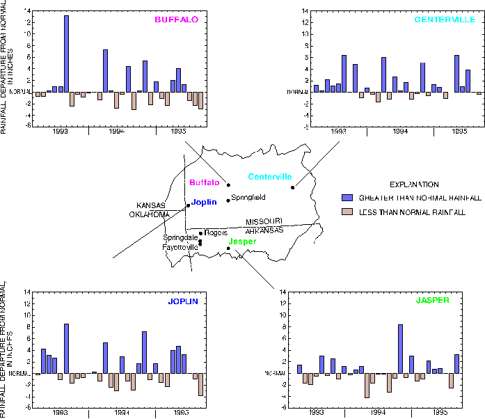
Hydrologic conditions (illustrated here as rainfall departure from normal) during the most intense period of sample collection (April 1993-September 1995) were relatively normal overall. However, during certain periods rainfall and streamflow were far from normal in some parts of the Study Unit. For example, in September 1993 rainfall in the northern part of the Ozarks exceeded normal amounts by as much as 6 to 13 inches. This caused streamflows at several stations in the northern Ozarks to reach levels that would be expected to occur (on average) once every 10 or more years. In April 1994 rainfall in the northern part of the Ozarks exceeded normal amounts by 6 to nearly 11 inches. In November 1994 rainfall generally exceeded normal amounts by 4 to 8 inches throughout the Study Unit. Extended periods (greater than 2 months) of less than normal rainfall occurred infrequently and in few areas during the study period.
Suggested citation:
Petersen, J.C., Adamski, J.C., Bell, Davis, J.V., Femmer, S.R., Freiwald,
D.A., and Joseph, R.L., 1998, U.S. Geological Survey Circular 1158, on
line at < URL: https://water.usgs.gov/pubs/circ1158>, updated
April 3, 1998
This page is a subpage of <URL:http://water.usgs.gov/pubs/circ1158>
Email questions and comments to GS-W_NAWQA_Outreach@usgs.gov
Last modified: 4/3/98