![]()
The San Joaquin-Tulare Basins NAWQA Study Unit is located in central California and includes the San Joaquin Valley, the eastern slope of the Coast Ranges, and the western slope of the Sierra Nevada.
The Sierra Nevada are predominantly forested land, and the Coast Ranges and the foothills of the Sierra Nevada are rangeland. Almost the entire valley floor is used for agricultural land. In 1987, about 10.5 million acres in the San Joaquin Valley was farmland (San Joaquin Valley Drainage Program, 1990, p. 50). Abundant water, combined with the long growing season, results in an exceptionally productive agricultural economy in the San Joaquin Valley. In 1987, approximately 10.2 percent of the total value of agricultural production in the United States came from California, 49 percent of which, or $6.82 billion, was from the San Joaquin Valley.
Thirty-eight percent of the surface water is imported from the Sacramento-San Joaquin Delta through the Delta-Mendota Canal and California Aqueduct (U.S. Bureau of Reclamation, 1990; California Department of Water Resources, 1991). Most of the rest of the surface water is from the Sierra Nevada. Surface water from the Sierra Nevada is of very high quality, but major changes in water quality occur when surface water enters the San Joaquin Valley. These changes are primarily due to the large amount of irrigated agriculture, which affects the quality of both surface and ground water in the valley.
Irrigation return water may reach surface water as direct runoff (tailwater), as water from subsurface drainage systems installed to control the water table, or as ground water discharged through riverbeds. The result can be increased concentrations of dissolved solids, nutrients, pesticides, and, in some areas, trace elements. Irrigation is the largest source of recharge to the regional aquifer, and this ground-water recharge can contain higher concentrations of dissolved solids than natural recharge in the past. This recharge also may contain elevated concentrations of nutrients, pesticide residues, and trace elements.
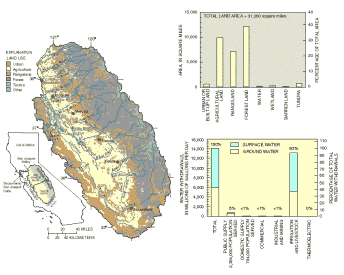
Irrigation of agricultural land on the valley floor is the primary use of water in the San Joaquin-Tulare Basins.
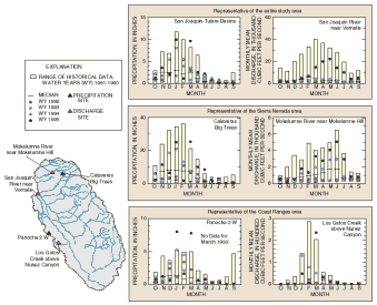
The distribution of precipitation, and consequently runoff, in the San Joaquin-Tulare Basins is highly influenced by topography. Mean annual precipitation on the valley floor ranges from less than 5 inches in the south to 15 inches in the north. Precipitation in the Coast Ranges varies from less than 10 inches (at Panoche 2 W) to more than 20 inches. Average annual precipitation in the Sierra Nevada, mostly in the form of snow, ranges from about 20 inches in the lower foothills to more than 80 inches at some higher elevation sites (Calaveras Big Trees).
 (36,404 bytes)
Hydrologic conditions during the intensive data-collection phase were highly variable.
Hydrologic conditions during the intensive data collection phase (1992-95 water years [WYs]) of the San Joaquin-Tulare Basins NAWQA were variable. Precipitation in WYs 1993 and 1995 was above the 1961-90 average of 19.4 inches (42 and 70 percent, respectively). The 1992 and 1994 WYs were slightly below average (16 and 26 percent, respectively). Approximately 80 percent of the annual precipitation normally occurs from November to March. The temporal distribution of precipitation during the intensive data collection phase followed this pattern, with slightly greater departure from average during drier years.
Total streamflows at the San Joaquin River near Vernalis site, during WYs 1992-94, were 48 to 78 percent below average, whereas streamflow during WY 1995 was 91 percent above average. Eighty-five percent of the streamflow normally occurs from November to March in the Coast Ranges, reflecting the pattern of precipitation. In the Sierra Nevada, and in the San Joaquin-Tulare Basins as a whole, only 40 to 50 percent of the streamflow occurs from November to March; the greater proportion of the streamflow comes from snowmelt stored in the reservoirs, which is not released until later in the spring. During the intensive data-collection period there was little departure (less than 10 percent) from these temporal patterns, except in 1995 at the San Joaquin River near Vernalis where more of the streamflow occurred during the spring.