![]()
The Snake River often is referred to as a working river because of its highly regulated streamflow. Five reservoirs on the main stem of the Snake River have a combined storage capacity of more than 4 million acre-feet, and eight reservoirs on Snake River tributaries have storage capacities of more than 50,000 acre-feet each [11]. Numerous dams and diversions, primarily for irrigation and hydroelectric power generation, have resulted in smaller streamflows and streamflow velocities, alterations in biological communities, and growth of nuisance aquatic plants. Other water uses in the upper Snake River Basin are domestic and public supply, fish farms, and confined-animal feeding operations. Inputs of nutrients, organic wastes, and other pollutants from these sources have degraded the water quality in many streams in the upper Snake River Basin.
In 1990, water use in Idaho totaled 22 million acre-feet (about 20,000 million gallons per day), ranking third in the Nation behind California and Texas. Of this total, nearly 70 percent was used in the upper Snake River Basin [2]. Use of surface water and ground water in the basin was about equal--about 8 million acre-feet (7,100 million gallons per day) was diverted from surface-water supplies, and about 7.1 million acre-feet (6,300 million gallons per day) was withdrawn from ground-water supplies [2].
Most of the economy in the upper Snake River Basin is dependent on industries that require ample sources of high-quality water. Currently, the largest water uses in the basin are irrigated agriculture, food processing and other industries, public supply, fish farms, and hydroelectric power facilities [2]. Irrigated agricultural, industrial, and public supply water uses are partially consumptive in that water is withdrawn from the source, transported to the point of use, and at least partially consumed. Fish farms and hydroelectric power facilities are nonconsumptive uses because all the water used is returned to streams.
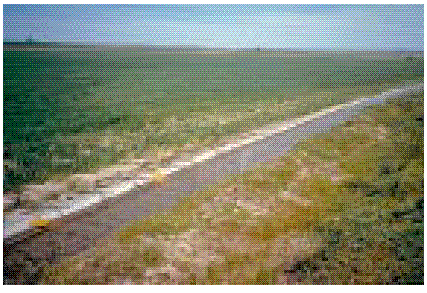
Diversion canals, like this one at American Falls Reservoir, supply irrigation water for large tracts of land adjacent to the Snake River in Idaho. In 1990, about 8 million acre-feet of water was diverted from streams in the basin to irrigate about 4.7 million acres of agricultural land (photograph by G.M. Clark, U.S. Geological Survey).
 (25,199 bytes)
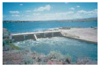
Diversions of water from the Snake River have a large effect on stream discharge. Shoshone Falls on the Snake River near Twin Falls, Idaho, is an impressive sight during high stream discharge. During the irrigation season, however, discharge over the falls can be reduced to a mere trickle (photographs by G.M. Clark, U.S. Geological Survey).
About half of the total surface-water diversions in the upper Snake River Basin are from five canals at Lake Walcott and Milner Dam for irrigation of about 575,000 acres of agricultural land [12]. Some of the water applied to fields for irrigation infiltrates to the ground water or returns to streams by way of canals, also transporting sediment, fertilizers, and pesticides [4]. Because of diversions, streamflows in the Snake River often are reduced substantially during many months of the year. Low streamflows, combined with instream reservoirs, have transformed some reaches of the Snake River from a high-gradient, coldwater river to a slow-moving, warmwater river supporting primarily nongame species of fish [6].
In 1990, domestic and public supply systems provided less than 150,000 acre-feet (130 million gallons per day) of water to about 400,000 people in the upper Snake River Basin. More than 80 percent of this water was derived from ground-water supplies. Domestic and public supplies accounted for less than 1 percent of the total basin water use [2]. However, as the population in the basin continues to grow, the demand for high-quality water for domestic and public supplies will grow accordingly.
 (14,542 bytes)
Streamflow in the Snake River during the nonirrigation season (January, for example) is typical of an unregulated stream--streamflow increases with downstream distance. During the irrigation season (August, for example), streamflow in the Snake River fluctuates substantially over its length in response to diversions, irrigation return flows, and ground-water discharge.
 (32,584 bytes)
Historically, furrow irrigation has been the primary method of watering crops. Excess irrigation water either infiltrates to underlying aquifers or returns to streams (photograph by M.A. Maupin, U.S. Geological Survey).
 (16,361 bytes)
Ground water has become an increasingly important source for agricultural and domestic water needs. In 1990, 47 percent of the water used in the basin was supplied by ground water (photograph by M.G. Rupert, U.S. Geological Survey).
Fish farms and hydroelectric power facilities are the primary nonconsumptive water uses in the basin. Fish farms along the Snake River between Milner Dam and King Hill used about 2,500 cubic feet per second of ground-water discharge as source water in 1995 [4]. When water passes through a fish farm, it becomes enriched with nitrogen, phosphorus, and suspended sediments, which eventually are discharged to the Snake River [4].
As available surface-water supplies have diminished, use of ground water in the upper Snake River Basin has increased substantially. From 1980 to 1990, annual ground-water use in the basin increased from 2.6 million acre-feet (2,300 million gallons per day) to 7.1 million acre-feet (6,300 million gallons per day) [2]. In 1980, ground water accounted for only 22 percent of the total basin water use. In 1990, ground water accounted for about 47 percent. As a result, ground-water levels in some areas of the basin have declined since 1980 [5,13]. Although most of the increase in ground-water use has been for irrigated agriculture, the number of confined-animal feeding operations in the lower parts of the basin that rely on ground-water supplies has been increasing rapidly [8]. In some areas of the basin where agriculture and confined-animal feeding operations are prominent, small concentrations of pesticides and nitrate concentrations exceeding the U.S. Environmental Protection Agency (USEPA) drinking-water standard of 10 milligrams per liter have been detected in water from domestic wells [5,13].
 (11,616 bytes)
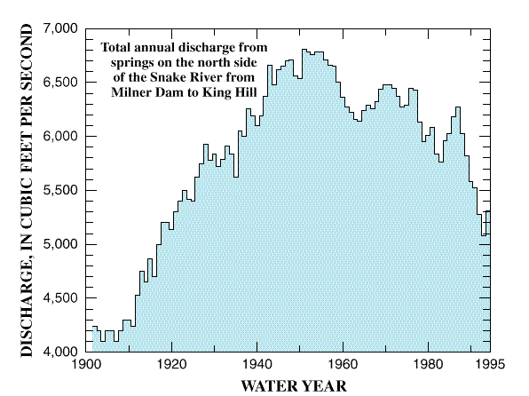
Total discharge from springs along the north side of the Snake River from Milner Dam to King Hill reflects historical changes in water-use patterns. Spring discharge increased substantially from the early 1900's to the late 1950's in response to an increase in ground-water recharge from surface-water irrigation. A general decline in discharge since the mid- to late 1950's is attributable to an increase in ground-water pumpage for irrigation and other purposes.
 (19,512 bytes)
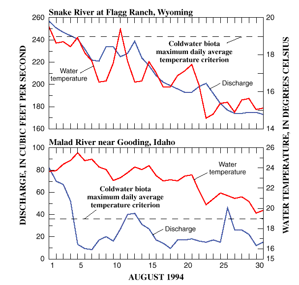
Streamflow diversions for other uses can result in warmer water temperature, which is detrimental to most native species of fish. At the Snake River at Flagg Ranch, Wyoming, a site with natural hydrologic conditions, even during the warmest period of the year (August), the temperature criterion of 19 degrees Celsius is rarely exceeded. However, at the Malad River near Gooding, Idaho, a site affected by diversions, the temperature criterion is often exceeded during the entire month of August.