![]()
|
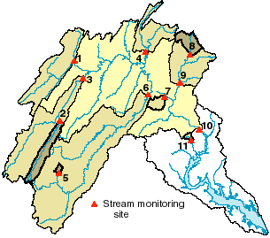
Figure 29. Stream chemistry was monitored at 11 sites in the basin (see table 5). Of these sites, four (sites 5, 6, 8, and 11) were also monitored more intensively for pesticides, and two (sites 5 and 11) were monitored more intensively for ecology. |
Figure 30. Streambed sediment was sampled at 26 sites in the basin. Of these sites, 21 were also sampled for aquatic tissues (Asiatic clams or yellow bullhead). |
|
Number |
|||
|---|---|---|---|
|
South Fork South Branch Potomac River near Moorefield, W. Va. |
|||
|
Study component1 |
||||
|---|---|---|---|---|
|
Concentrations of trace elements and organic compounds in sediment were measured to determine their occurrence and spatial distribution in sediments in streams of the basin. |
Depositional zones of the Potomac River and selected tributaries. |
4
|
||
|
Concentrations of major ions, suspended sediment, organic carbon, and nutrients were measured in water samples collected monthly and during selected high flows to describe the occurrence of those compounds in streams over time. |
Streams of the basin, at or near sites where streamflow is measured continuously. |
|||
|
Concentrations of pesticides were measured in water samples collected during selected high flows and weekly during a growing season to determine the timing of transportation of such compounds to streams. |
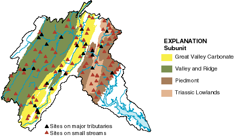
Subset of basic sites, including streams draining predominantly agricultural or urban areas. |
|||
|
Concentrations of major ions, nutrients, pesticides, and suspended sediment were measured in water samples collected during stable, intermediate flow to relate the occurrence and spatial distribution of those chemical compounds to potential sources in contributing watersheds. |
Selected tributaries of the Potomac River draining watersheds of greater than about 100 square miles. |
(see fig. 31) |
||
|
Concentrations of nutrients, pesticides, suspended sediment, and major ions were measured in water samples collected during low flows to determine the occurrence and spatial distribution of those compounds in streams across the basin and relate the stream chemistry to land use and other watershed characteristics. |
Small streams draining watersheds of less than 37 square miles. |
(see fig. 31) |
||
|
Concentrations of organic compounds in whole fishes and clams and concentrations of trace metals in fish livers and clams were measured to determine the occurrence and spatial distribution of metals and organic compounds that can accumulate in aquatic tissues. |
(see fig. 30) |
|||
|
Fish, macroinvertebrates, and algae were identified and counted and quantitative assessments of stream habitat were conducted to determine the variability of biological communities and habitat representing primary ecological regions of the basin on a small scale. |
||||
|
Fish, macroinvertebrates, and algae were identified and counted and quantitative assessements of stream habitat were conducted to determine the habitat and community structure of aquatic species in representative streams across the basin. |
(see fig. 31) |
|||
|
Concentrations of nutrients, pesticides, organic carbon, radon, uranium, tritium, and major ions were measured in water samples to describe the chemistry of ground water in the Piedmont and Triassic Lowlands (fig. 3). |
Randomly selected subset of previously existing shallow (mostly less than 300 feet deep) wells. |
(see fig. 32) |
||
|
Concentrations of nutrients, pesticides, organic carbon, radon, uranium, tritium, and major ions were measured in water samples to describe the chemistry of ground water within particular land-use settings and relate the differences in ground-water chemistry to natural and human factors. |
Randomly selected subset of previously existing shallow (mostly less than 300 feet deep) wells within agricultural or forested areas. |
(see fig. 32) |
||
|
Concentrations of nutrients, pesticides, organic carbon, radon, uranium, tritium, and major ions were measured in water samples to relate their occurrence and distribution on a small scale to land use and other factors and evaluate their transport from the land surface to ground water and from ground water to streams. |
Streams and shallow (mostly less than 50 feet deep) wells installed along an approximate line of ground-water flow within a small (less than 2 square miles) watershed. |
(see fig. 32) |
||
1Gerhart and Brakebill, 1997; Gilliom and others, 1995.