![]()
Water quality in the Lower Susquehanna River Basin is affected by diverse geologic conditions and land-use factors. The intense agricultural activity, in conjunction with the importance of the Lower Susquehanna River Basin as a major source of freshwater to the Chesapeake Bay, makes runoff of nitrogen one of the most important water-quality issues. Contamination of stream water and ground water by pesticides and other organic chemicals, which are used in agricultural and urban areas, is another important issue. Much of the rural population, which relies on ground water for household water supply, is in areas underlain by limestone bedrock. The shallow limestone aquifers in valleys of primarily agricultural land use are vulnerable to contamination by activities on the land surface. The effect of urban and mining land uses on water quality are also important issues.
Drinking-water standards (U.S. Environmental Protection Agency, 1996a) apply only to waters used for public supply that have been filtered and treated (finished water). The NAWQA Program is designed to assess natural waters, not finished waters. The standards were only used in this report to place the observed concentrations in samples from wells used as household drinking-water supplies and samples from streams into a common frame of reference. Aquatic-life criteria (U.S. Environmental Protection Agency, 1996b) and other measures were used to assess the ecological health of the streams. Selected ecological data for invertebrates and algae have not been analyzed and are not included in the major findings. Major findings for nutrients, pesticides, selected contaminants in ground water, contaminants in fish tissue and streambed sediment, fish-community structure and health, and stream habitat are presented to illustrate the quality of the water resources.
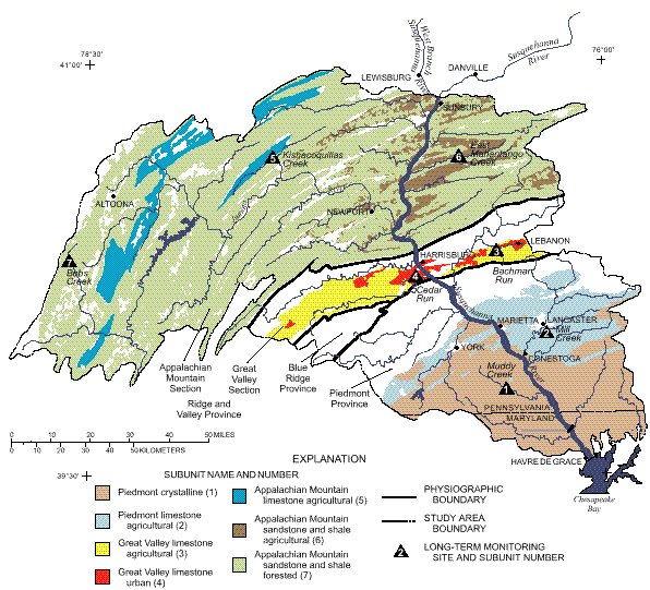
The study was designed to address natural and human factors affecting water quality. The design was an integrated assessment of water quality including stream-water chemistry, stream-water ecology, and ground-water chemistry. Some assessments involved large geographic areas of the Study Unit (basinwide studies), whereas other assessments focused on specific environmental settings (subunit studies). From the 14 major environmental settings based on land use, bedrock type, and physiography, 7 subunits (see table below and map on page 7) were selected to provide the basis for assessing the effects of land use and bedrock type on water quality.
Long-term monitoring sites (see table below and map on page 7) were established in one stream in each of the seven subunits to evaluate the temporal variation in stream-water chemistry and ecology. To assess stream-water chemistry, samples were collected monthly to weekly at each of the seven long-term monitoring sites for a total of 316 samples over the study period. Most of the samples were collected when flow was low and dominated by ground water (base flow). Relatively few stormflow samples were collected at the long-term monitoring sites; therefore, issues such as the transport of phosphorus and ammonia, which are predominantly transported during storms, cannot be assessed. The first 3 years of data collection are not sufficient to detect trends in the water-quality conditions, but these data serve as a baseline for future studies. Detailed ecological studies of fish, invertebrates, and algae also took place at each of these seven long-term monitoring sites. The structure and health of the fish community were assessed, and characteristics of the stream habitat were analyzed.
Basinwide studies were done to determine ecological conditions and the occurrence of contaminants. Streambed-sediment samples were collected at 21 sites, and fish-tissue samples were collected at 20 sites. These sites (see map on page 28) included all of the long-term monitoring sites except for Bobs Creek and Cedar Run. Studies of biological communities and stream habitat were done at an additional 45 sites (see map on page 28).
Synoptic studies were done to evaluate the conditions of a selected area during a specific time period. Subunit studies also enhanced the understanding of processes such as those that influence the relation between ground-water quality and stream-water quality. The subunit-synoptic sampling sites were located within the colored areas on the map below; individual sites for ground-water and stream-water synoptic studies are shown on the site maps on page 28. Wells or streams within the subunits were sampled to determine the variations in water quality among areas of different bedrock type, land use, and physiography. Synoptic studies of stream-water chemistry took place at 187 sites and were focused geographically on individual subunits or on basinwide issues.
Synoptic studies of the chemical and bacterial quality of ground water were done in the subunits by collecting well-water samples at 169 sites. Ground-water sampling was done as a land-use study (collecting samples from an area of a single land-use type) or as a subunit survey (collecting samples from all land uses within a selected aquifer). The sandstone and shale subunit survey was limited geographically to the eastern area of the basin and included parts of the forested and agricultural subunits. Only six subunit-synoptic studies of ground water were done. For data-analysis purposes, however, the samples from the forested and agricultural areas of the sandstone and shale subunit survey were considered separately to allow comparisons to the seven surface-water subunits. Not all issues were studied in each subunit; for example, bacteriological studies were not done in the urban subunit. Moreover, not all analyses were done at each of the 169 sites, so the number of samples available for data analysis varies.
An outline of the sampling plans is given in the table on page 29. Details of the sampling for studies of water quality are given in Siwiec and others (1997). Data from this study are published in Durlin and Schaffstall (1994, 1996, 1997).
The study design was based on a combination of land use, physiography, and bedrock type. This map and table (page 6) illustrate and describe the subunits that formed the basis of the study. The subunits are the colored areas; streams used as long-term monitoring basins are labeled.