![]()
Table of contents || Previous section || Next section || Glossary || PDF document
 (18,484 bytes)
 (17,278 bytes)
 (14,881 bytes)
| Study component | What data were collected and why | Types of sites sampled and water-quality measures | Number of sites or studies | Sampling frequency [period] |
|---|---|---|---|---|
| Ground-Water Quality | ||||
| Basinwide survey - surficial aquifers | Describe overall water quality in surficial sand and gravel aquifers which are susceptible to contamination. | Sample 20-30 wells in three of the major subregions for major ions, nutrients, pesticides, organic carbon, and radionuclides. | 69 | 1 |
| Basinwide survey - buried aquifers | Describe the overall water quality and natural chemical patterns in buried aquifers. | Sample wells within a west-east area across the central part of the Study Unit for major ions and trace elements; nutrients and radionuclides collected from 27 wells. | 42 | 1 |
| Land-use effects | Determine the effects of specific land use on the quality of shallow ground water. | For two surficial aquifers lying mostly beneath irrigated cropland, sample wells completed near water table for major ions, nutrients, and pesticides; from one aquifer, sample for volatile-organic compounds and radionuclides. | 58 | 1 |
| Seasonal variations | Determine seasonal variation of concentrations of water-quality indicators in aquifers studied for land-use effects. | Resample selected wells in each aquifer studied for land-use effects for nutrients, major ions, and organic carbon. | 16 | 4-5 per year, [1994–95] |
| Variations along flow | Describe land-use effects on surficial aquifers along ground-water flow from areas of recharge beneath the land use to area of discharge to a stream. | Sample clusters of wells installed along an approximate line of ground-water flow and at various depths within aquifers studied for land-use effects; analyze for major ions, nutrients, pesticides, and age-dating constituents. | 19 | 1 |
| Stream-Water Quality | ||||
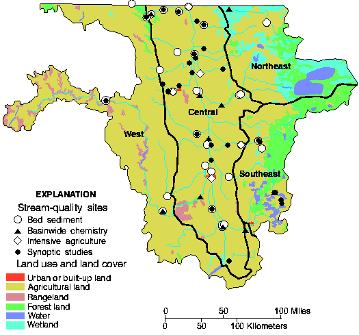
| Bed-sediment survey | Determine presence of potentially toxic compounds attached to sediments in major streams. | Sample depositional zones of the Red River and selected tributaries for trace elements, PAHs, and organochlorine compounds. | 22 | 1 [1992] |
| Bed-sediment distribution survey | Determine distribution of toxic compounds attached to sediment in streams. | Sample sites in addition to bed-sediment survey sites mostly for trace elements. | 8 | 1 |
| Basinwide stream-chemistry sites | Describe concentrations and loads of chemicals, suspended sediment, and nutrients at selected sites basinwide. | Sample for major ions, organic carbon, suspended sediment, and nutrients at or near sites where streamflow is measured continuously. | 15 | ~14 per year, [1993-95] |
| Intensive agriculture sites | Determine concentration and timing of agriculture related compounds that are transported to streams. | Subset of basinwide stream-chemistry sites where 80 pesticides are sampled at least monthly and during selected runoff events. | 5 | ~20 per year, [1993-95] |
| Synoptic studies | Describe short-term presence and distribution of contamination over broad areas and how well the stream-chemistry stations represent the entire Red River Basin. | Sample streams during high flow for pesticides and (or) nutrients, suspended sediment, organic carbon, and streamflow; one synoptic sampling for volatile organic compounds. | 27 | 1 |
| Stream sediment | Describe the role of suspended sediment in transporting nutrients in streams. | Map stream-channel geometry and collect sediment samples during spring runoff and storm flows at selected sites along the Pembina River. | 1 | 12 |
| Aquatic Biology | ||||
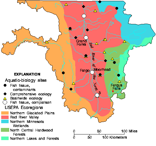
| Fish tissues, contaminants | Determine presence of contaminants that can accumulate in fish tissues. | Collect fish species that live in most streams of the Study Unit; sample composites of whole fish for organic compounds and fish livers for trace elements. | 11 | 1 [1992] |
| Comprehensive ecology | Assess in detail biological communities and habitat in streams representing primary ecological regions. | Sample and quantify fish, macroinvertebrates, and algae in four of the major ecological regions located at or near a basinwide stream chemistry site; quantitatively describe stream habitat for these organisms; replicate sampling for three consecutive years over three stream reaches. | 6 | 1 per year, [1993-95] |
| Basinwide ecology | Determine presence and community structure of aquatic species and habitat in representative streams across the Study Unit. | Sample and identify fish, macroinvertebrates and algae at or near stream-chemistry sites and describe habitat. | 16 | 1 |
| Fish tissues, comparison | Determine differences in concentrations of mercury in different fish tissues in the Red River. | Sample two sizes of carp at four sites and catfish at one site in the Red River for mercury concentration in livers, fillets, and whole bodies. | 4 | 1 |