
Hydrologic Benchmark Network Stations in the West-Central U.S. 1963-95 (USGS Circular 1173-C)
|
|
|
|
|
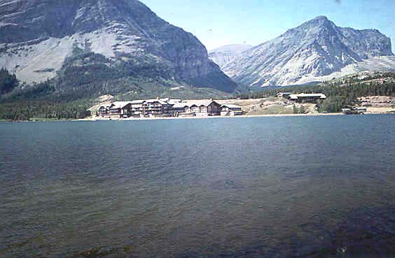
Swiftcurrent Creek at Many Glacier, Montana (05014500)
Hydrologic Benchmark Network Stations in the West-Central U.S. 1963-95 (USGS Circular 1173-C)
|
|
|
|
|
Swiftcurrent Creek at Many Glacier, Montana (05014500)
To download a printer friendly PDF version of this information click here.
This report details one of the approximately 50 stations in the Hydrologic Benchmark Network (HBN) described in the four-volume U.S. Geological Survey Circular 1173. The suggested citation for the information on this page is:
|
Clark, M.L., Eddy-Miller, C.A., Mast, M.A., 2000, Environmental characteristics and water-quality of Hydrologic Benchmark Network stations in the West-Central United States, U.S. Geological Survey Circular 1173-C, 115 p. |
All of the tables and figures are numbered as they appear in each circular. Use the navigation bar above to view the abstract, introduction and methods for the entire circular, as well as a map and list of all of the HBN sites. Use the table of contents below to view the information on this particular station.
|
Table of Contents |
| 1. Site Characteristics and Land Use |
| 2. Historical Water Quality Data and Time-Series Trends |
| 3. Synoptic Water Quality Data |
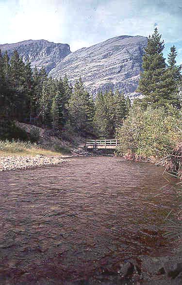
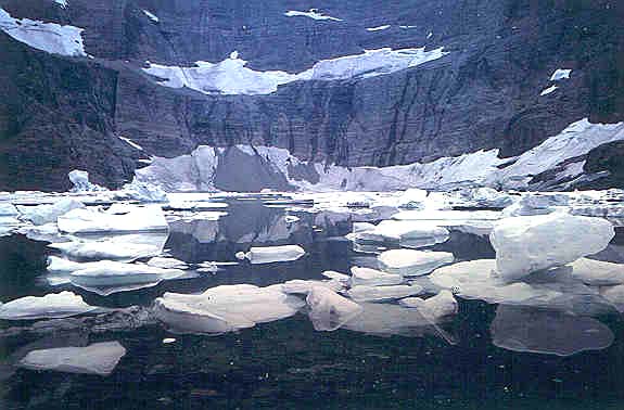
The Swiftcurrent Creek HBN Basin lies within the Northern Rocky Mountain physiographic province (Fenneman, 1946) in northern Montana (Figure 10. Map showing study area in the Swiftcurrent Creek Basin and photograph of the Grinnell Creek Basin). The HBN station is at the outlet of Swiftcurrent Lake in Glacier National Park, about 18 km southwest of Babb, Mont., at a latitude of 48×47'57'' and a longitude of 113×39'21''. Swiftcurrent Creek at the HBN station drains 80 km² of rugged, mountainous terrain on the east side of the Rocky Mountains, entirely within Glacier National Park. Vertical rock exposures make for abrupt changes in basin topography; elevations range from 1,500 to 3,000 m. The ecoregion of
 |
Swiftcurrent Creek is a perennial, high-gradient mountain stream; several small glaciers near the Continental Divide form the headwaters of the stream. The basin has a snowmelt-dominated hydrograph; mean monthly discharges on Swiftcurrent Creek ranged from 0.75 m³/s in February to 14 m³/s in June (Shields and others, 1996). Average annual precipitation increases in the basin with increasing elevation. Average annual precipitation at the Many Glacier weather station is about 100 cm; higher elevations may receive closer to 200 cm. Precipitation falls predominantly in the form of snow. Average annual runoff is about 160 cm (Shields and others, 1996). The winters are cold and summers mild; mean monthly temperatures ranged from about -10.7×C in January to 14.8×C in July at the Many Glacier station during the period 1967-95 (National Climatic Data Center, 1996). Temperatures in the basin decrease with increasing elevation.
 |
The Swiftcurrent Creek HBN Basin lies entirely within the boundaries of Glacier National Park. The access to the HBN station is by paved road. Just beyond the HBN station, park facilities are clustered along Swiftcurrent Lake. The rest of the basin, including Grinnell Lake, Bullhead Lake, and Iceberg Lake, is accessible only by hiking trail. Between December and April, the road to the station usually is impassable owing to snow and generally is closed at the Many Glacier park entrance. During this time, the HBN station is most accessible by skis, snowshoes, or mountain bike (N.A. Midtlyng, U.S. Geological Survey, oral commun., 1997). The basin is essentially undeveloped except for park facilities, including a few hotels, campground, and ranger station, which are typically open from Memorial Day to Labor Day. The water supply for the facilities is withdrawn from the basin upstream from the HBN station; sewage disposal is downstream from the station. Recreational use of Glacier National Park is high. About 157,400 people used the park's backcountry during the summer season of 1988 (Coen, 1992). More than 95 percent of the backcountry users were day hikers. Other activities in the basin include fishing, backcountry camping, and some cross-country skiing. Several large lakes, which interrupt the steep stream gradients, lie in the basin. Wildlife is diverse and abundant in the park, including bighorn sheep, mountain goats, black and grizzly bear, whitetail and mule deer, moose, and wolves.
Samples for chemical analyses have not been collected routinely at the Swiftcurrent Creek HBN station. The data set analyzed for this report includes 83 measurements of instantaneous discharge and 82 measurements of specific conductance for the period October 1963 to July 1994 (table 18). The entire period of record for discharge at the Swiftcurrent Creek HBN station is from 1959 to 1997. Median values and ranges of discharge and specific conductance are shown in table 18. Discharge ranged from 0.19 to 40 m³/s, with a median discharge of 3.1 m³/s. The range of specific conductance for the period was 70 to 131 mS/cm, with a median value of 104 mS/cm. Specific conductance can be used as an indicator of the dissolved solids (Hem, 1992, p. 165). Based on the range of specific-conductance values, dissolved solids generally are low at this site. Streams in basins with high annual runoff tend to have low dissolved-solids concentrations (Biesecker and Leifeste, 1975). Specific conductance had an inverse relation with discharge. The Spearman rank correlation coefficient was -0.674.
[Discharge in cubic meters per second; specific conductance in microsiemens per centimeter at 25 degrees Celsius; n, number of measurements]
|
Parameter |
Stream water |
|||||
|
Minimum |
First quartile |
Median |
Third quartile |
Maximum |
n |
|
| Discharge |
0.19 |
1.4 |
3.1 |
8.2 |
40 |
83 |
| Specific conductance, field |
70 |
97 |
104 |
111 |
131 |
82 |
Results of a surface-water synoptic sampling conducted August 1-3, 1992, in the Swiftcurrent Creek Basin are
 |
[Site locations shown in fig. 10; Q, discharge in cubic meters per second; SC, specific conductance in microsiemens per centimeter at 25 degrees Celsius; pH in standard units; Ca, calcium; Mg, magnesium; Na, sodium; K, potassium; Alk, alkalinity; SO4, sulfate; Cl, chloride; NO3, nitrate; SiO2, silica; concentrations in microequivalents per liter, except silica is in micromoles per liter; --, not measured; <, less than; criteria used in selection of sampling sites: BG = bedrock geology, TRIB = major tributary, LU = land use]
|
Site |
Identification number |
Q |
SC |
pH |
Ca |
Mg |
Na |
K |
Alk |
SO4 |
Cl |
NO3 |
SiO2 |
Criteria |
|
1 |
484649113443200 |
0.22 |
75 |
8.0 |
600 |
160 |
13 |
2.0 |
730 |
33 |
<0.3 |
4.3 |
20 |
BG |
|
2 |
484717113440800 |
.23 |
106 |
8.3 |
800 |
260 |
13 |
3.3 |
1,000 |
29 |
<.3 |
.7 |
25 |
TRIB |
|
3 |
484754113411700 |
-- |
107 |
8.2 |
750 |
300 |
17 |
2.8 |
1,000 |
21 |
37 |
.6 |
23 |
TRIB |
|
4 |
484903113443500 |
.14 |
84 |
8.2 |
550 |
250 |
13 |
2.8 |
750 |
56 |
<.3 |
3.6 |
17 |
BG |
|
5 |
484920113424000 |
.06 |
175 |
8.2 |
1,000 |
700 |
35 |
7.4 |
1,500 |
48 |
<.3 |
8.6 |
52 |
TRIB |
|
6 |
484753113404500 |
.28 |
120 |
8.2 |
600 |
160 |
8.7 |
4.6 |
1,100 |
19 |
<.3 |
.7 |
20 |
TRIB |
|
7 |
484739113395800 |
.94 |
110 |
8.3 |
750 |
330 |
22 |
3.3 |
1,000 |
35 |
<.3 |
1.9 |
28 |
LU |
|
8 |
484604113414500 |
.064 |
125 |
8.2 |
800 |
410 |
17 |
4.1 |
1,200 |
23 |
<.3 |
8.6 |
37 |
TRIB |
|
9 |
484528113432600 |
-- |
49 |
7.9 |
360 |
120 |
8.7 |
2.3 |
430 |
19 |
2.8 |
<.7 |
12 |
BG |
|
10 |
484614113415500 |
1.5 |
114 |
8.2 |
550 |
240 |
13 |
2.8 |
800 |
38 |
<.3 |
3.6 |
22 |
TRIB |
|
11 |
05014500 |
2.9 |
102 |
8.8 |
700 |
330 |
17 |
3.1 |
980 |
48 |
.3 |
<.7 |
27 |
-- |
The water at the remaining synoptic sites (sites 1-10) also is an alkaline, calcium bicarbonate type. The sum of ions in tributaries in the basin ranged from 940 meq/L in upper Grinnell Creek (site 9) to 3,300 meq/L in Ptarmigan Creek (site 5). Water quality in the tributaries is a function of drainage size and underlying bedrock. The specific conductance in upper Grinnell Creek (49 mS/cm) was less than the minimum specific conductance (70 mS/cm) measured at the HBN station for the period of record, 1964-94. Site 1 and site 4 also had low specific conductance (75 and 84 mS/cm, respectively). The small drainage area and extensive exposures of resistant bedrock at these sites probably accounts for their low dissolved solids. The highest specific conductance was at site 5 on Ptarmigan Creek (175 mS/cm); that value exceeds the maximum specific conductance of 131 mS/cm measured at the HBN station for the period of record.
Bailey, Robert G., 1995, Descriptions of the ecoregions of the United States: U.S. Department of Agriculture, Forest Service, Miscellaneous Publication 1391, 108 p.
Biesecker, J.E., and Leifeste, D.K., 1975, Water quality of hydrologic benchmarks-An indicator of water quality in the natural environment: U.S. Geological Survey Circular 460-E, 21 p.
Carrara, P.E., 1990, Surficial geologic map of Glacier National Park, Montana: U.S. Geological Survey Miscellaneous Investigation Series Map I-1508-D.
Coen, Brenda, ed., 1992, Science in Glacier National Park: National Park Service Annual Report, 1991-92, 72 p.
Earhart, R.L., Raup, O.B., Whipple, J.W., Ison, A.L., and Davis, G.A., 1990, Geologic maps, cross section, and photographs of the central part of Glacier National Park, Montana: U.S. Geological Survey Miscellaneous Investigation Series Map I-1508-B.
Fenneman, N.M., 1946, Physical divisions of the United States: Washington, D.C., U.S. Geological Survey special map, scale 1:7,000,000.
Hem, J.D., 1992, Study and interpretation of the chemical characteristics of natural water: U.S. Geological Survey Water-Supply Paper 2254, 263 p.
National Climatic Data Center, 1996, Summary of the day, CD-ROM: Boulder, Colorado, EarthInfo Incorporated.
Shields, R.R., White, M.K., Ladd, P.B., and Chambers, C.L., 1996, Water resources data, Montana, water year 1995: U.S. Geological Survey Water-Data Report MT-95-1, 521 p.
a. U.S. Geological Survey topographic maps:
b. Geologic maps:
c. Soil surveys:
No soil survey available.
Table B-1. NWIS site-identification numbers and site names for water-quality sampling sites.
|
Site |
Identification Number |
Site Name |
|
1 |
484649113443200 |
Swiftcurrent Creek above Bullhead Lake |
|
2 |
484717113440800 |
unnamed creek below Windmaker Lake |
|
3 |
484754113411700 |
Swiftcurrent Creek above Fishercap Lake |
|
4 |
484903113443500 |
Iceberg Creek |
|
5 |
484920113424000 |
Ptarmigan Creek above falls |
|
6 |
484753113404500 |
Wilbur Creek above Fishercap Lake |
|
7 |
484739113395800 |
Swiftcurrent Creek above Swiftcurrent Lake |
|
8 |
484604113414500 |
Cataract Creek |
|
9 |
484528113432600 |
upper Grinnell Creek |
|
10 |
484614113415500 |
Grinnell Creek below Grinnell Lake |
|
11 |
05014500 |
Swiftcurrent Creek at Many Glacier, Montana |
| Back to 1173-C Contents |
This page maintained by Nichole Bisceglia.
Last updated July 31, 2000.