Hydrologic Benchmark Network Stations in the West-Central U.S. 1963-95 (USGS Circular 1173-C)
|
|
|
|
|

Hydrologic Benchmark Network Stations in the West-Central U.S. 1963-95 (USGS Circular 1173-C)
|
|
|
|
|
To download a printer friendly PDF version of this information click here.
This report details one of the approximately 50 stations in the Hydrologic Benchmark Network (HBN) described in the four-volume U.S. Geological Survey Circular 1173. The suggested citation for the information on this page is:
|
Clark, M.L., Eddy-Miller, C.A., Mast, M.A., 2000, Environmental characteristics and water-quality of Hydrologic Benchmark Network stations in the West-Central United States, U.S. Geological Survey Circular 1173-C, 115 p. |
All of the tables and figures are numbered as they appear in each circular. Use the navigation bar above to view the abstract, introduction and methods for the entire circular, as well as a map and list of all of the HBN sites. Use the table of contents below to view the information on this particular station.
|
Table of Contents |
| 1. Site Characteristics and Land Use |
| 2. Historical Water Quality Data and Time-Series Trends |
| 3. Synoptic Water Quality Data |
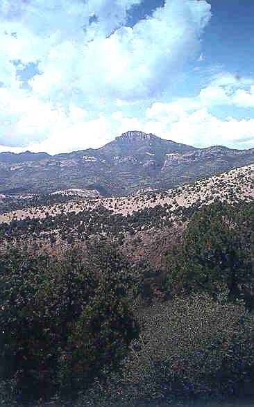
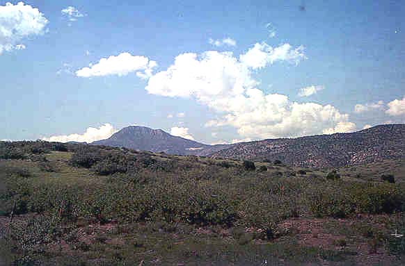
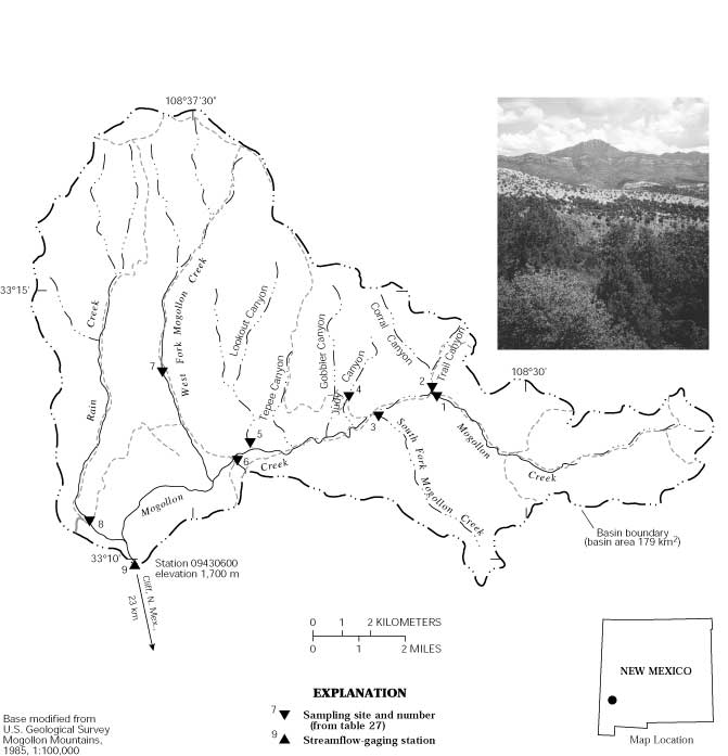
The Mogollon Creek HBN Basin is in the Mexican Highland Section of the Basin and Range physiographic province (Fenneman, 1946) in southwestern New Mexico (Figure 13. Map showing study area in Mogollon Creek Basin and photograph of a mountain peak in the basin). The HBN station is about 23 km north of the town of Cliff,
 |
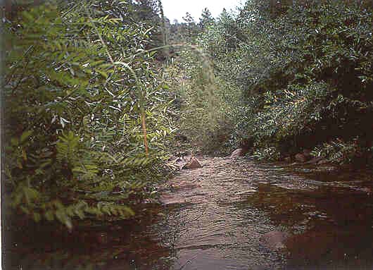
Mogollon Creek is an intermittent stream that typically goes dry in the summer months. Discharge is dependent upon rainfall. Mean monthly discharge ranges from 0.10 m³/s in June to 2.1 m³/s in March (Ortiz and Lange, 1996). Average annual precipitation received at the Cliff weather station, about 15 km southeast of the site, is about 37 cm. About 10 percent of the precipitation falls as snow (Cobb and Biesecker, 1971). Average annual runoff is about 17 cm (Ortiz and Lange, 1996). Mean monthly temperatures ranged from 3.6×C in December to 24.4×C in July during the period 1948-95 (National Climatic Data Center, 1996).
The surficial geology of the basin is composed of a series of Tertiary-age extrusive or shallow intrusive volcanic units (Ratte´ and Gaskill, 1975). The area near the HBN station is underlain by a quartz latite of Oligocene age. The unit is described as compositionally zoned ash-flow tuff at least 600 m thick. Parts of the middle basin are underlain by latitic and andesitic lava flows. Other parts of the middle basin are underlain by rhyolite, which includes porphyritic lava
 |
The Mogollon Creek HBN station is in Grant County. The Mogollon Creek HBN Basin lies almost entirely within the Gila National Forest except for some private land near the station. Most of the National Forest land within the basin is within the Gila Wilderness Area, which was the first wilderness area designated in the United States (Ratte´ and Gaskill, 1975). A private, unimproved dirt road provides access to the HBN station. Pack trails access several tributaries in the drainage; wilderness area access is limited to foot trails and horseback. Recreational activity is limited, as access is limited by private holdings. Several prospect pits or open cuts from historical mining are in the Rain Creek drainage. Some cattle grazing occurs in the basin.
The data set analyzed for the Mogollon Creek HBN station includes 158 water-quality samples that were collected from February 1967 to September 1995. Sampling frequency is described on the basis of water year, which begins on October 1 and ends on September 30. Sampling frequency was highest during the early part of the record; 11 samples per year were collected during water years 1968-70. Sampling frequency decreased to three to six samples per year from 1972 through 1995. Samples were analyzed at the USGS New Mexico District water-quality laboratory until early 1970. From early 1970 through 1973, samples were analyzed at the USGS water-quality laboratory in Salt Lake City, Utah. After 1973, with the creation of the USGS Central Laboratory System, all samples were analyzed at the water-quality laboratory (now called NWQL) in Arvada, Colo. The period of record for discharge is from water year 1967 to current year (2000).
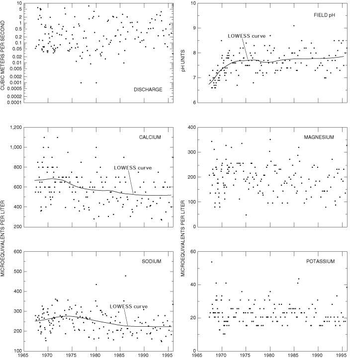
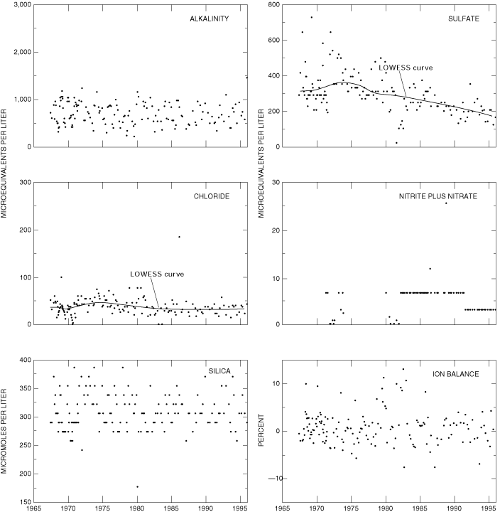
Data quality was checked using ion balances and time-series plots. Calculated ion balances for samples with complete major-ion analyses are shown in Figures 14a and 14b. Temporal variation of discharge, field pH, major dissolved constituents, and ion balance at Mogollon Creek, New Mexico More than 95 percent of the samples had ion balances within the ±10 percent range, indicating that the major-ion analytical results generally were of good quality and that
 |
The median and range of major-ion concentrations in the stream water collected at the Mogollon Creek HBN station and VWM concentrations in wet precipitation measured at the Gila Cliff Dwellings National Monument NADP station are presented in table 24. The NADP station is about 46 km northeast of the HBN station. Precipitation chemistry at the NADP station is dilute and acidic with VWM pH of 4.8 during the period of record, 1985-95. This was the lowest VWM pH for the NADP stations used in this report. The dominant cation in precipitation was hydrogen, which contributed 44 percent of the total cation concentration; calcium contributed 22 percent and ammonium contributed 16 percent. The dominant anion in precipitation was sulfate, which contributed 58 percent of the total anion concentration; nitrate contributed 31 percent.
[Parameters in units of microequivalents per liter, except for discharge in cubic meters per second, specific conductance in microsiemens per centimeter at 25 degrees Celsius, pH in standard units, and silica in micromoles per liter; n, number of stream samples; VWM, volume-weighted mean; spec. cond., specific conductance; --, not reported; <, less than]
|
Parameter |
Stream Water |
Precipitation VWM |
|||||
|
Minimum |
First quartile |
Median |
Third quartile |
Maximum |
n |
||
| Discharge | <0.01 | 0.06 | 0.22 | 0.88 |
|
158 |
|
| Spec. cond., field | 47 | 82 | 108 | 122 |
|
158 |
|
|
pH, field
|
6.6 | 7.3 | 7.6 | 7.9 |
|
157 |
|
| Calcium | 270 | 460 | 600 | 700 |
|
158 |
|
| Magnesium | 48 | 150 | 200 | 240 |
|
158 |
|
| Sodium | 150 | 200 | 250 | 280 |
|
157 |
|
| Potassium | 10 | 18 | 23 | 26 |
|
157 |
|
| Ammonium | <.7 | .7 | 1.4 | 4.3 |
|
|
|
| Alkalinity, laboratory | 220 | 520 | 680 | 880 |
|
158 |
|
| Sulfate | 23 | 230 | 290 | 350 |
|
157 |
|
| Chloride | <2.8 | 28 | 39 | 48 |
|
157 |
|
| Nitrite plus nitrate | <.7 | <3.6 | <7.1 | 7.1 |
|
|
|
| Silica | 180 | 290 | 310 | 320 |
|
158 |
|
a Laboratory pH.
b Nitrate only.
Stream water in Mogollon Creek is a mildly alkaline, calcium bicarbonate type. The sum of ion concentrations ranged from about 1,000 to about 3,700 meq/L. Alkalinity ranged from 220 to 1,500 meq/L, and bicarbonate was the primary contributor to alkalinity at this station. The predominant cation in the stream water was calcium, which contributes 56 percent of the median cation concentration. Sodium was the second most abundant cation in the stream water. These
 |
Correlations among dissolved constituents and discharge were determined for Mogollon Creek (table 25). The base cations and anions showed inverse relations with discharge. These results are consistent with a hydrologic system where base-flow chemistry that is dominated by ground water is diluted from precipitation runoff during periods of increased discharge. Ion concentrations in ground water tend to be greater than in surficial sources because the contact time with rocks and minerals is longer. Sulfate was poorly correlated (rho value = -0.047) with discharge, indicating that another process may be contributing to sulfate concentrations. Accumulations of sulfate salts in soils and subsequently flushing during precipitation may weaken the discharge-dilution relationship. Strong correlations existed among the base cations calcium, magnesium, and sodium. Rho values were 0.954 (calcium and magnesium), 0.933 (calcium and sodium), and 0.904 (magnesium and sodium). These cations also were strongly correlated with alkalinity, with rho values that ranged from 0.922 for magnesium and 0.938 for sodium.
[Q, discharge; Ca, calcium; Mg, magnesium; Na, sodium; K, potassium; Alk, alkalinity; SO4, sulfate; Cl, chloride; SiO2, silica; --, not applicable]
|
|
Q |
pH |
Ca |
Mg |
Na |
K |
Alk |
SO4 |
Cl |
| pH |
-0.313 |
-- |
-- |
-- |
-- |
-- |
-- |
-- |
-- |
| Ca |
-.736 |
0.272 |
-- |
-- |
-- |
-- |
-- |
-- |
-- |
| Mg |
-.665 |
.286 |
0.954 |
-- |
-- |
-- |
-- |
-- |
-- |
| Na |
-.822 |
.251 |
.933 |
0.904 |
-- |
-- |
-- |
-- |
-- |
| K |
-.460 |
.182 |
.647 |
.665 |
0.601 |
-- |
-- |
-- |
-- |
| Alk |
-.798 |
.310 |
.937 |
.922 |
.938 |
0.611 |
-- |
-- |
-- |
| SO4 |
-.047 |
.146 |
.358 |
.396 |
.248 |
.372 |
0.191 |
-- |
-- |
| Cl |
-.247 |
.207 |
.487 |
.542 |
.478 |
.327 |
.447 |
0.430 |
-- |
| SiO2 |
-.014 |
.009 |
.290 |
.370 |
.237 |
.367 |
.247 |
.232 |
-0.001 |
Results of the seasonal Kendall test for trends in discharge and major dissolved constituents for Mogollon Creek during the period of record, 1967-95, are presented in table 26. Statistically significant downward trends (a = 0.01) were observed for unadjusted concentrations of calcium, sodium, sulfate, and chloride. Downward trends remained after adjusting concentrations of calcium and sulfate for discharge variations. A statistically significant upward trend was observed for pH. No trend was observed for alkalinity. A downward trend in alkalinity was observed at this station by Smith and Alexander (1983) for the period from late 1960's to 1981. The downward trend for sulfate may be attributed to decreasing atmospheric sulfur dioxide concentrations following compliance with more stringent air-quality regulations and decreased production in nearby copper smelters (U.S. Geological Survey, 1993). Sulfur-dioxide emissions decreased by 33 percent in New Mexico during the period 1975-84 (Lins, 1987). The sulfate concentrations decreased around 1982 and 1990, however, when the analytical method changes for sulfate also occurred. Insufficient data existed for nitrate to calculate a trend. The scatter in the time-series plot for nitrate concentrations is a function of a change in the minimum reporting level for the laboratory method about 1991, rather than an environmental change.
[Trends in units of microequivalents per liter per year, except for discharge in cubic meters per second per year, pH in standard units per year, and silica in micromoles per liter per year; p-value, attained significance level; --, not calculated; <, less than]
|
Parameter |
Unadjusted |
Flow adjusted |
||
|
Trend |
p-value |
Trend |
p-value |
|
| Discharge |
0.1 |
0.115 |
-- |
-- |
| pH |
.01 |
.006 |
0.02 |
0.005 |
| Calcium |
-6 |
<.001 |
-3 |
.006 |
| Magnesium |
-.9 |
.08 |
-.1 |
.836 |
| Sodium |
-2 |
.001 |
-.9 |
.016 |
| Potassium |
<.01 |
.056 |
-.04 |
.590 |
| Alkalinity |
<.01 |
.922 |
2 |
.138 |
| Sulfate |
-7 |
<.001 |
-7 |
<.001 |
| Chloride |
-.5 |
.003 |
-.4 |
.024 |
| Nitrite plus nitrate |
(a) |
-- |
-- |
-- |
| Silica |
<.01 |
.472 |
(b) |
-- |
a Insufficient data to calculate trend.
b Concentration-flow model not significant at a = 0.10.
Results of a surface-water synoptic sampling conducted August 27-30, 1991, in the Mogollon Creek Basin are presented in table 27, and locations of the sampling sites are shown in figure 13. Discharge at the HBN station (site 9) was 0.48 m³/s compared to the mean monthly discharge of 0.44 m³/s for the month of August (Ortiz and Lange, 1996). The water type in the basin is mixed. Percent contributions of the major cations, calcium, magnesium, and sodium, change within the basin. Calcium was the predominant cation at each site, but the percent contribution ranged from 41 percent (site 1) to 62 percent (site 8). The water type in the upper basin (sites 1 and 2) and on the West Fork Mogollon Creek tributary (site 7) was a calcium-sodium-magnesium bicarbonate. The percent magnesium was higher at sites 3, 4, and 6; the water type was a calcium-magnesium-sodium bicarbonate. The higher magnesium at these sites is coupled with higher bicarbonate concentrations. The water type at sites 5, 8, and 9 was calcium bicarbonate.
[Site locations shown in fig. 13; Q, discharge in cubic meters per second; SC, specific conductance in microsiemens per centimeter at 25 degrees Celsius; pH in standard units; Ca, calcium; Mg, magnesium; Na, sodium; K, potassium; Alk, alkalinity; SO4, sulfate; Cl, chloride; NO3, nitrate; SiO2, silica; concentrations in microequivalents per liter, except silica is in micromoles per liter; --, not measured; <, less than; criteria used in selection of sampling sites: BG = bedrock geology, TRIB = major tributary, LU = land use]
|
Site |
Identification number |
Q |
SC |
pH |
Ca |
Mg |
Na |
K |
Alk |
SO4 |
Cl |
NO3 |
SiO2 |
Criteria |
|
1 |
331304108320700 |
-- |
54 |
7.4 |
220 |
96 |
180 |
38 |
260 |
160 |
28 |
<3.6 |
370 |
BG |
|
2 |
331305108320800 |
-- |
66 |
7.4 |
260 |
96 |
240 |
28 |
400 |
150 |
34 |
<3.6 |
400 |
BG |
|
3 |
331240108332500 |
<0.001 |
115 |
7.1 |
600 |
330 |
250 |
24 |
890 |
230 |
23 |
<.7 |
500 |
BG |
|
4 |
331259108340000 |
<.002 |
211 |
7.4 |
900 |
690 |
380 |
21 |
1,600 |
330 |
37 |
<.7 |
550 |
BG |
|
5 |
331203108361200 |
-- |
65 |
7.8 |
350 |
80 |
180 |
18 |
400 |
140 |
20 |
<3.6 |
300 |
BG |
|
6 |
331153108363100 |
<.001 |
114 |
7.0 |
550 |
350 |
290 |
9.5 |
870 |
200 |
23 |
<.7 |
480 |
BG |
|
7 |
331329108381100 |
-- |
101 |
7.3 |
550 |
220 |
230 |
20 |
760 |
160 |
25 |
<3.6 |
380 |
TRIB |
|
8 |
331039108395200 |
-- |
77 |
7.7 |
470 |
100 |
170 |
12 |
550 |
140 |
16 |
<3.6 |
250 |
TRIB, LU |
|
9 |
09430600 |
.48 |
80 |
8.0 |
490 |
140 |
240 |
18 |
620 |
140 |
23 |
<3.6 |
320 |
-- |
The total ions ranged from about 980 (site 1) to about 4,000 meq/L (site 4); the concentration at the HBN station (site 9) was 1,700 meq/L. In general, concentrations of dissolved constituents of tributaries generally were within the range of dissolved constituents at the HBN station for the period of record, 1967-95 (table 24), except for the unnamed tributary in Judy Canyon (site 4). The unnamed tributary in Judy Canyon contained higher concentrations of magnesium, alkalinity, and silica. The sample collected at the HBN station contained dissolved-constituent concentrations that were generally less than the median value for the period 1967-95 (table 24). Four of the tributary sites (sites 2, 3, 4, and 6) contained silica at a concentration greater than the maximum concentration detected at the HBN station during 1967-95 (table 24). The changes in stream chemistry reflect the different weathering rates of the different volcanic units; however, because of the heterogeneous geology in each drainage, it is difficult to isolate which lithologic units are controlling ion concentrations. All sites had silica concentrations that were high owing to the quartz-rich volcanic rocks in the basin. Concentrations of the major cation, calcium, and the major anion, bicarbonate, increased by twofold in Mogollon Creek between the upper sampling site (site 1) and the HBN station (site 9). The percent difference of cations and anions ranged from 0.1 to 7.8 percent, indicating that unmeasured ions did not substantially contribute to the ionic composition of the water. Nitrate concentrations were low in all basins and were characteristic of undeveloped areas (Mueller and others, 1995).
Bailey, Robert G., 1995, Descriptions of the ecoregions of the United States: U.S. Department of Agriculture, Forest Service, Miscellaneous Publication 1391, 108 p.
Cobb, E.D., and Biesecker, J.E., 1971, The National Hydrologic Benchmark Network: U.S. Geological Survey Circular 460-D, 38 p.
Fenneman, N.M., 1946, Physical divisions of the United States: Washington, D.C., U.S. Geological Survey special map, scale 1:7,000,000.
Lins, H.F., 1987, Trend analysis of monthly sulfur dioxide emissions in the conterminous United States, 1975-1984: Atmospheric Environment, v. 21, no.11, p. 2297-2309.
Mueller, D.K., Hamilton, P.A., Helsel, D.R., Hitt, K.J., and Ruddy, B.C., 1995, Nutrients in ground water and surface water of the United States-An analysis of data through 1992: U.S. Geological Survey Water-Resources Investigations Report 95-4031, 74 p.
National Climatic Data Center, 1996, Summary of the day, CD-ROM: Boulder, Colorado, EarthInfo Incorporated.
Ortiz, David, and Lange, K.M., 1996, Water resources data, New Mexico, water year 1995: U.S. Geological Survey Water-Data Report NM-95-1, 629 p.
Ratte´, J.C., and Gaskill, D.L, 1975, Reconnaissance geologic map of the Gila Wilderness Study Area, southwest New Mexico: U.S. Geological Survey Miscellaneous Investigation Series Map I-886, scale 1:62,500.
Ratte´, J.C., Gaskill, D.L., Eaton, G.P., Peterson, D.L., Stotelmeyer, R.B., and Meeves, H.C., 1979, Mineral resources of the Gila Primitive Area and Gila Wilderness, New Mexico: U.S. Geological Survey Bulletin 1451, 229 p.
Smith, R.A., and Alexander, R.B., 1983, Evidence for acid-precipitation-induced trends in stream chemistry at hydrologic benchmark stations: U.S. Geological Survey Circular 910, 12 p.
U.S. Geological Survey, 1983, Analytical methods-Sulfate determinations: Office of Water Quality Technical Memorandum No. 83.07, accessed December 27, 1999, at URL http://water.usgs.gov/admin/memo/.
U.S. Geological Survey, 1993, National water summary 1990-91-Hydrologic events and stream water quality: U.S. Geological Survey Water-Supply Paper 2400, 590 p.
a. U.S. Geological Survey topographic maps:
b. Geologic maps:
c. Soil surveys:
No soil survey available.
d. Other maps:
Table B-1. NWIS site-identification numbers and site names for water-quality sampling sites.
|
Site |
Identification Number |
Site Name |
|
1 |
331304108320700 |
Mogollon Creek above Trail Canyon |
|
2 |
331305108320800 |
unnamed tributary in Trail Canyon |
|
3 |
331240108332500 |
South Fork Mogollon Creek |
|
4 |
331259108340000 |
unnamed tributary in Judy Canyon |
|
5 |
331203108361200 |
unnamed tributary in Lookout Canyon |
|
6 |
331153108363100 |
unnamed tributary below Lookout Canyon |
|
7 |
331329108381100 |
West Fork Mogollon Creek |
|
8 |
331039108395200 |
Rain Creek |
|
9 |
09430600 |
Mogollon Creek near Cliff, New Mexico |
| Back to 1173-C Contents |
This page maintained by Nichole Bisceglia.
Last updated July 31, 2000.