INTRODUCTION TO THE LONG ISLAND–NEW JERSEY STUDY AREA
 |
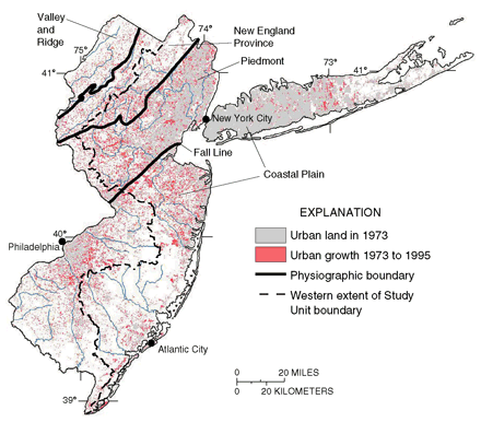
| Figure 1. Urban land and associated human activities have a major influence on water quality and aquatic life. |
Environmental Setting and Hydrologic Conditions
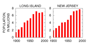
The study area covers 6,000 square miles (mi²) of the LINJ Study Unit plus an additional 3,300 mi² in western New Jersey (fig. 1). About 15 million people (fig. 2) live in the study area, which includes some of the most densely populated metropolitan centers of the Nation. For more than two centuries, a prosperous commercial and industrial economy has centered on the seaports of New York City and Philadelphia. In the early 1970s, 22 percent of the study area was developed as urban residential, commercial, or industrial. By the mid-1990s, urban land use had grown to 33 percent of the area (fig.1), with a corresponding 11-percent decrease in forest and agricultural land. Population growth for the same period was about 8 percent overall, despite a slight population decline on Long Island (fig. 2).
 |
| Figure 2. The population of Long Island and New Jersey is more than four times larger than it was in 1900. |
The cost of land and the pressure for development have
reduced agricultural activities in the area. For example, agriculture
constituted nearly 60 percent of the land use in 1900. By the mid-1990s,
agriculture accounted for only 14 percent of the land use. The more intensive
agricultural areas that still remain are in eastern Long Island and in
western and southern New Jersey. The remaining 53 percent of the study
area in the mid-1990s was undeveloped land, principally forest (31 percent),
wetlands (16 percent), and water (6 percent). As demonstrated since the
1970s, however, agricultural and undeveloped areas are rapidly becoming
urbanized.
About two-thirds of the study area is in the Coastal Plain (fig. 1), which
is characterized by flat to gently rolling topography developed on unconsolidated
sedimentary (New Jersey and Long Island) and glacial deposits (Long Island
only). The other one-third, north of the Fall Line, is characterized by
rolling to hilly topography of weathered bedrock with glacial deposits
in the northernmost part. As much as 80 percent of the streamflow in the
Coastal Plain is derived from ground-water discharge, whereas response
to rainfall in northern New Jersey is dominated by surface runoff. Most
of western Long Island, northeastern New Jersey, and the corridor between
New York City and Philadelphia consists of heavily urbanized and thus
relatively impervious areas that yield runoff rapidly. Ground-water pumping
considerably reduces base flow in streams on the western part of Long
Island.
 |
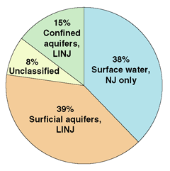
| Figure 3. Nearly 80 percent of the study-area drinking-water supply is from a vulnerable surficial aquifer or surface-water source. |
Water-supply systems in the study area are highly connected, and transfer of water across drainage divides and among basins is common. For example, about 100 million gallons per day (Mgal/d) is transferred from the Delaware River Basin to the Raritan River Basin in the Delaware and Raritan Canal. The Kirkwood-Cohansey aquifer system and the outcrop of the Potomac-Raritan-Magothy aquifer system are the principal surficial aquifers in the New Jersey Coastal Plain. Glacial deposits of sand and gravel overlie most of Long Island and form the surficial aquifer. To a large extent, the surficial aquifer is underlain by and hydraulically connected to the deeper Magothy aquifer, the principal source of water for Long Island.
Total freshwater withdrawals in the study area for all uses in 1995 were greater than 1,600 Mgal/d (Clawges and others, 1999). Almost 80 percent of that amount was either from surface-water sources (streams, canals, or lakes) or from surficial ground-water sources (fig. 3); all of these sources are highly vulnerable to contamination (Clawges and others, 1999). Most of the water-supply sources in the study area, therefore, are highly vulnerable to contamination from overlying and upstream human activities.
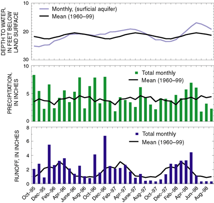
Annual precipitation and runoff during the NAWQA water-quality sampling years (1996–98) were above normal compared to their 40-year mean (table 1). The months of higher than normal precipitation and runoff, however, were mainly from October 1995 through December 1996. Precipitation and runoff were generally near normal after December 1996, except for the summer months in 1997 and 1998 (fig. 4).
 |
| Figure 4. Hydrologic conditions during the study period (water years 1996–98). Water-level data are for a monitoring well in the Kirkwood-Cohansey aquifer system; precipitation and runoff are for the Raritan River Basin. |
The advisory committee for the LINJ NAWQA study identified
two major water-quality concerns: (1) the effects of nonpoint-source runoff
on streams, lakes, and estuaries, including aquatic biological communities,
and (2) the vulnerability of public and domestic water supplies to contamination
resulting from urban and agricultural activities. A wealth of data was
available on contaminants such as VOCs, pesticides, nutrients, and trace
elements, which are known to be related to high population density, urban
and industrial development, and agricultural activities. Information on
the processes governing contaminant occurrence, movement, and biological
effects, however, was limited. Therefore, the LINJ study design (p.
28–29) focused on collection of data that would help describe these
processes as well as add to the current knowledge of contaminant occurrence.
Modeling approaches were used to help in the design of data collection
and analyses of environmental factors and trends.
| Table 1. Precipitation and runoff (in inches) during the 1996-98 sampling period were above the 40-year means |
||||
|
|
40-year mean |
1996 |
1997 |
1998 |
|---|---|---|---|---|
|
Precipitation |
47.4 |
59.9 |
52.0 |
48.8 |
|
Runoff |
20.6 |
28.5 |
26.6 |
20.8 |
Although hydrology and geology differ among parts of the study area, analyses of available chemical and biological data indicate that land use is the primary differentiating factor for much of the water-quality variability across the study area. The LINJ study design, therefore, focused considerable attention toward understanding the specific aspects of land use that control observed water quality and aquatic biological communities.
New information derived from the LINJ study is presented here to increase the understanding of (1) the effect of changing landscapes on stream aquatic life, (2) the occurrence of trace elements, nitrate, pesticides, and VOCs and other organic compounds in streams and aquifers, especially those used for drinking-water supply, and (3) implications of potential trends in water quality and aquatic biological communities in urban and agricultural areas.
| Table of Contents || Previous Section || Next Section || Glossary U.S. Geological Survey Circular 1201 Suggested citation:
|

