
Stream Chemistry and Ecology
Surface-water assessments included water, bed sediment, and fish tissue chemistry; fish, invertebrate, and algal communities; and physical habitat. Sites were chosen across the study area for spatial coverage and distribution in the major aquatic ecological settings within the Allegheny and Monongahela River Basins (fig. 26). Basic and intensive sites were sampled monthly for chemistry and annually for ecological condition. One urban site and one agricultural site also were intensively sampled during storms to assess the influence of storm runoff on stream contaminant concentrations. Eighty-nine additional synoptic sites were sampled once to assess the influence of coal mining on water quality across the study area.
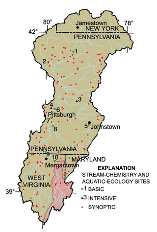 |
| Figure 26. In addition to intensive water-quality sampling at a few sites, one-time sampling at many sites across the study area provided data related to specific land uses. The Cheat River Basin (shaded pink) was similarly sampled. |
Ground-Water Chemistry
Two reconnaissance-type studies were done. The first focused on the fractured-rock aquifers of the coal-bearing Pittsburgh Series rocks of middle and late Pennsylvanian age. The second was set in the coarse- and fine-grained glaciofluvial deposits of the valley-fill aquifers in the northern area of the Allegheny River Basin (fig. 27). An additional study that focused on mining land use involved sampling of wells that drew water from the fractured-rock aquifers and that were near surface coal mines where mining and reclamation efforts have been completed. The quality of these samples was compared to that of water from 15 wells sampled in unmined areas of the same aquifers.
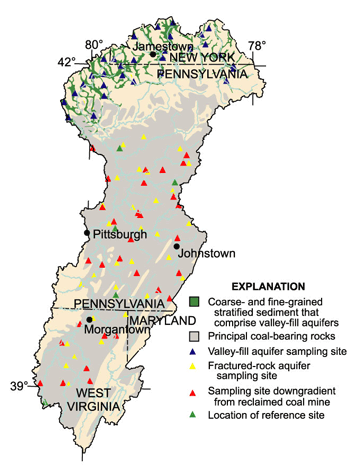 |
| Figure 27. Ground water was sampled from two major aquifer systems, valley-fill aquifers of the northern Allegheny River Basin, and fractured-rock aquifers in the Pittsburgh Series rocks that contain the largest quantities of commercially minable bituminous coal in the ALMN. |
|
Site number (fig. 26) |
Site name | Site type | Basin area (square miles) |
Site number (fig. 26) |
Site name | Site type | Basin area (square miles) |
|---|---|---|---|---|---|---|---|
1 |
East Hickory Creek near Queen, Pa. |
Forested |
20.3 |
6 |
Allegheny River at New Kensington, Pa. |
Mixed |
11,50 |
2 |
French Creek at Utica, Pa. |
Mixed |
1,028 |
7 |
Monongahela
River at |
Mixed |
7,337 |
3 |
South Branch Plum Creek at Five Points, Pa. |
Agriculture |
33.3 |
8 |
Youghiogheny
River at |
Mixed |
1,715 |
4 |
Deer
Creek near |
Urban |
27.0 |
9 |
Dunkard
Creek at |
Mining |
4,440 |
5 |
Stonycreek
River at |
Mining |
451 |
10 |
Cheat River near Mt. Nebo, W. Va. |
Mixed |
1,132 |
| Study component |
What data were collected and why |
Types of sites sampled |
Number of sites |
Sampling frequency and period |
|---|---|---|---|---|
| Stream Chemistry |
||||
| Basic Sites-- General water chemistry |
Concentrations, seasonal variation, and annual loads. Data included streamflow, field measurements, major ions, nutrients, organic carbon, suspended sediment, trace elements. |
Basic Fixed Sites: Representative of common land-use mixes, as well as basin outflow sites. |
8 |
Monthly, April 1996-Sept. 1998 |
| Intensive sites-- Pesticides and VOCs |
Concentrations and seasonal variations in pesticides. Data included same constituents as above, plus 83 pesticides (dissolved) and 87 volatile organic compounds (VOCs) (only 1 site). |
Basic Fixed Sites with intensive urban or agricultural land use. |
2 |
1997, 1998 |
| Contaminants in bed sediments |
Occurrence and distribution of contaminants in bed sediment. Data include trace elements, organochlorine compounds, and volatile organic compounds. |
Depositional zones of most stream sites sampled in other components of study. |
19 |
Monthly and more |
| Contaminants in fish tissue |
Occurrence and distribution of contaminants in biota. Data included total PCBs, 30 organochlorine pesticides in whole fish, and 24 trace elements in fish livers. |
Most stream sites sampled in other components of study where tissue could be collected. |
17 |
Fish Tissue: Summer 1996 and Summer 1997 (Duplicate taxa at |
| Stream Ecology |
||||
| Ecological assessments |
Macroinvertebrates (benthic invertebrates), fish, algae, aquatic and riparian habitat. |
Basic Fixed Sites. |
8 |
1996-97 (10 sites), 1998 (6 sites) |
| Synoptic studies |
Unmined basin to compare to mined basins. The same data were collected at Basic Sites. |
Synoptic Site. |
1 |
Once in 1997 |
| Ground-Water Chemistry |
||||
| Aquifer survey-- |
Assess quality across aquifer extent. Data include field measurements, major ions, trace metals, nutrients, Pesticides, VOCs, radon, dissolved organic carbon (DOC). |
Existing domestic wells chosen with a statistically random selection process. Well depth range 30 to 250 feet. |
30 |
Once in 1996 |
| Aquifer survey-- |
Assess quality across aquifer extent. Data include field measurements, major ions, nutrients, pesticides, VOCs, radon, dissolved organic carbon (DOC). |
Existing domestic wells chosen with a statistically random selection process. Well depth range 30 to 250 feet. |
30 |
Once in 1996 |
| Land-use effects-- |
Compare ground-water quality near reclaimed surface mines to that in unmined areas. Data include major ions, trace metals, nutrients, VOCs, radon, trace elements, dissolved organic carbon (DOC), chlorofluorocarbons (CFCs). |
Existing domestic wells chosen with a statistically random selection process. Well depth range 30 to 250 feet. (Data from 10 fractured-rock sampling sites were re-used as reference data in the Land-use effects study.) |
45 |
Once in 1997 |
| Special Studies |
||||
| Low-flow synoptic survey of streams in the Appalachian coal fields |
To assess quality of surface water relative to type and age of coal mining in the basins. Standard: Mine-drainage indicators, field measurements. Intensive: same as standard sites, plus: major ions, trace elements, macroinvertebrates, aquatic habitat. |
Standard Site
network. |
89 |
Standard sites: Once in summer 1998 |
| Table of Contents || Previous Section || Next Section || Glossary U.S. Geological Survey Circular 1202 Suggested citation:
|
