
INTRODUCTION TO THE LAKE ERIE-LAKE SAINT CLAIR DRAINAGES
Streams and aquifers in the Lake Erie-Lake Saint Clair Drainages study area provide water for 10.6 million people. The major water-quality issues in the study area are similar to those facing the rest of the Nation. Natural-resource managers are interested in the effects of urban and agricultural land use on the quality of surface water and ground water, specifically:
- pesticide and nutrient contamination of stream water used for public supply
- nutrient enrichment and sedimentation in streams and subsequent effects on aquatic biota
- impairment of aquatic life from bioaccumulation of organochlorine compounds and mercury
- consumption advisories for certain fish due to bioaccumulation of PCBs and mercury
- degradation of ground water used for domestic supply in areas of new residential development and areas of row-crops
Environmental setting and hydrologic conditions
Lake Erie is the 11th-largest freshwater lake in the world. About two-thirds of the Lake Erie watershed is in the United States, and is referred to as the Lake Erie-Lake Saint Clair Drainages. (For simplicity, this area will be referred to as the basin.) This 22,300-square-mile area includes sections of Michigan, Indiana, Ohio, Pennsylvania, and New York. The land surface is gently rolling to nearly flat lying. Eight major rivers, all with drainage areas greater than 500 square miles, flow into the system.
Land use
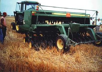 |
| Figure 1. Agriculture is a major industry in the western part of the basin, where corn and soybeans are grown. (Photograph from Natural Resources Conservation Service.) |
In the Lake Erie-Lake Saint Clair Drainages, about 75 percent of the land area is in agriculture, 11 percent is urban land, 11 percent is forest, and 3 percent is open water or wetlands. (See land-use map in summary section.)
Corn, soybeans, and wheat are grown predominantly in the western part of the basin (fig. 1). Other agricultural land uses include pasture and forage crops, grown predominantly in the eastern part of the basin (fig. 2). Orchards and vineyards, located mainly along the shores of Lake Erie and in parts of Michigan, is the least widespread type of agricultural land use.
 |
|
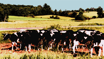
| Figure 2. Pasture and forage crops are found in the eastern part of the basin. |
Urban land is an important component of land use in the basin (fig. 3). Detroit and Pontiac, Mich.; Akron, Cleveland, Lima, and Toledo, Ohio; Fort Wayne, Ind.; Erie, Pa.; and Buffalo, N.Y., were historically significant contributors to industrial America through the production of automobiles, rubber, steel, petroleum, and chemicals. These cities remain important industrial and manufacturing centers. Major urban centers rely on abundant supplies of water for shipping, electric power generation, Industry, domestic consumption, and waste assimilation.
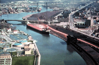 |
| Figure 3. The port of Toledo, Ohio, on the Maumee River exports large amounts of grain from Midwestern farms. Toledo is an industrial center for automobile manufacturing. (Photograph from Ohio Lake Erie Commission.) |
Forest and wetlands, once common throughout the basin, have been greatly reduced since the mid-1800s. The greatest percentage of forested land today is in Pennsylvania and New York. Metropolitan parks also support substantial urban forests. Wetlands lie primarily along Lake Erie and Lake Saint Clair from Detroit, Mich., to Sandusky, Ohio.
Geology
A layer of glacial deposits from 20 to 200 feet thick mantles the entire basin and overlies limestone, sandstone, or shale bedrock. The glacial sediments consist of sand and gravel, till, and fine-grained sediments composed of fine sands, silts, and clay (fig. 4). Sand and gravel are present as discontinuous deposits in river valleys and in the western part of the basin.The most widespread deposit is till, a mixture of grain sizes. Tills in the Lake Erie-Lake Saint Clair Drainages contain a high content of clay, which slows infiltration of rainfall into the ground.
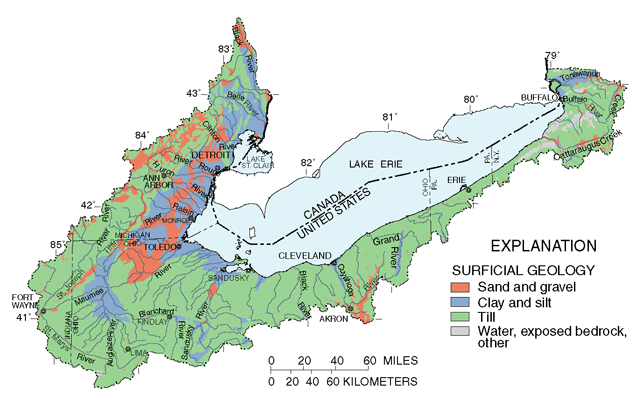 |
| Figure 4. Glacial deposits throughout the basin influence the quality and flow of surface water and ground water. |
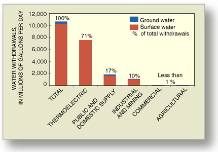 |
| Figure 5. Water withdrawals in the basin are dominated by thermoelectric power production. |
Water use
More than 10.6 billion gallons of water is used each day in the basin (fig. 5). Cooling during power generation accounts for 71 percent of the water use. Public and domestic supply account for 17 percent, and industry and mining account for 10 percent of the total use. Normal precipitation is generally adequate for agriculture, so irrigation accounts for less than 1 percent of water use.
Of the more than 1.8 billion gallons per day used for public and domestic supply, about 88 percent is from surface-water sources. Most of the major cities are near Lake Erie and Lake Saint Clair and therefore derive their water from the lakes or their connecting channels (fig. 6). Major rivers are an important source of drinking water for inland cities such as Fort Wayne, Ind., and Akron and Lima, Ohio.
About 12 percent of water for human consumption comes from ground water. The cities that use ground water as their major source of drinking water are generally inland (fig. 6). The most productive aquifers are in glacial deposits and limestone and sandstone bedrock.
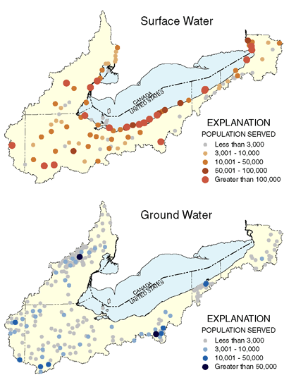 |
| Figure 6. Many public-water supplies with surface-water sources are near Lake Erie or major rivers, whereas public-water supplies with ground-water sources generally are some distance from the lake and major rivers. |
Hydrologic conditions
Average annual precipitation across the basin ranges from 28 to 47 inches. Precipitation is highest in the northeast because of lake effect, whereby cool, dry air picks up moisture as it travels over warmer lake water and then produces rain or snow as it reaches land. The lowest amounts of precipitation are in the northwestern part of the basin in Michigan. During the study, annual precipitation was 4 to 5 inches above the 30-year mean annual. Some areas received 13 inches of precipitation above the mean, and a few isolated areas received slightly less than the mean (fig. 7).
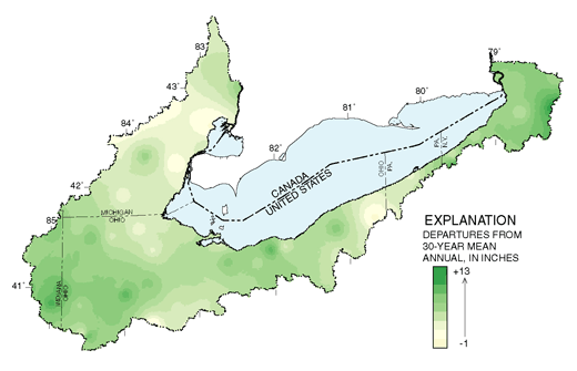 |
| Figure 7. Departures from 30-year mean annual precipitation patterns for water years 199698, based on data from 133 weather stations. |
The highest streamflows are typically in February, March, and April, as a result of increased precipitation, cold temperatures and little vegetative growth. The lowest streamflows are in August, September, and October (Casey and others, 1997). During low streamflow, ground water typically contributes most of the flow.
Mean monthly streamflows for the Maumee River at Waterville, Ohio, at the west end of the basin, exceeded the long-term averages by a factor of 2 or more for some months in 199798 (fig. 8). Overall, the mean annual streamflow in the Maumee River was 25 percent above average during the sampling period. For Cattaraugus Creek at Gowanda, N.Y., at the east end of the basin, mean monthly streamflow during 199698 closely followed the long-term average (fig. 8). In most areas of the basin, higher than average streamflows were observed in water years 199698.
Increased streamflow tends to carry higher concentrations of materials associated with land- surface runoff. Low streamflow conditions tend to increase concentrations of materials associated with industrial and municipal discharges or ground water.
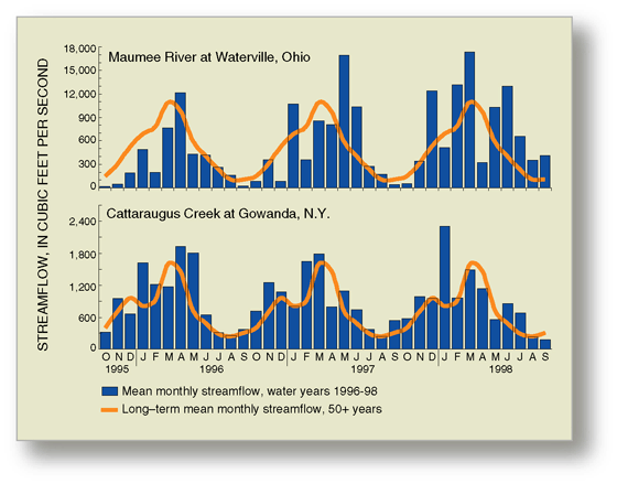 |
| Figure 8. Mean monthly streamflows during water years 199698 greatly exceeded long-term averages in some months. |
| Table of Contents || Previous Section || Next Section || Glossary U.S. Geological Survey Circular 1203 Suggested citation:
|
