
MAJOR FINDINGS—Continued
Bioaccumulative contaminants in fish may pose a risk to fish-eating wildlife
Where PCBs were detected in fish, they frequently posed a threat to fish-eating wildlife because of their high concentrations. PCBs were found in fish at 8 of 11 sites, and concentrations in fish from 6 sites exceeded the New York State guideline for the protection of fish-eating wildlife (table 2). The maximum concentration of PCBs found in fish was 25 times higher than the guideline set by the New York State Department of Environmental Conservation (NYSDEC) for the protection of fish-eating wildlife (Newell and others, 1987). These fish were collected from the Cuyahoga River at Cleveland, Ohio, a major river that flows through mixed-use land.
| Table 2. Summary of contaminant concentrations in fish tissue in relation to guidelines for the protection of fish-eating wildlife [mg/kg, micrograms per kilogram; NYSDEC, New York State Department of Environmental Conservation] |
![Table 2. Summary of contaminant concentrations in fish tissue in relation to guidelines for the protection of fish-eating wildlife [mg/kg, micrograms per kilogram; NYSDEC, New York State Department of Environmental Conservation].](images/leri_table002.gif) |
DDT was present in fish at 10 of 11 sites but concentrations in fish from only 2 sites exceeded the NYSDEC guideline. The highest concentrations of DDT were in whole fish in streams flowing through urban and mixed-use land—the Clinton River at Sterling Heights, Mich., and the Cuyahoga River at Cleveland, Ohio. Although mercury is a concern, no wildlife consumption guidelines have been established.
Fish-consumption restrictions for humans are based on contaminant concentrations in edible fish fillets, which are typically lower than those in whole fish. The contaminants of most concern in the Lake Erie Basin for human consumption of fish are mercury, PCBs, DDT, chlordane, and dieldrin. These are the same contaminants that are a concern for wildlife consumption (fig. 23). Because of widespread human consumption advisories for fish in the Lake Erie Basin, mercury and PCBs have been identified as critical pollutants and targeted by the USEPA and Environment Canada for cleanup and elimination (Daher, 1999).
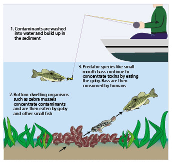 |
| Figure 23. Contaminants can bioaccumulate upward through the food web and may affect the health of human and animal consumers of fish. |
Land use appears to affect fish-community composition
Contaminants and nutrients in water and bed sediments appear to affect aquatic life, but human disturbance of physical stream habitat also is thought to be one of the most important causes of declines in certain fish species (Ohio Environmental Protection Agency, 1995). To differentiate the effects on fish of human disturbance from those of contaminants, sites considered to represent good to excellent stream habitat, as rated by the Qualitative Habitat Evaluation Index (QHEI) (Box 5) were selected for assessment of fish. Fish communities were assessed by means of the Index of Biotic Integrity (Box 5).
| Box 5—Index of Biotic
Integrity and Qualitative Habitat Evaluation Index Aquatic biological communities are sensitive indicators of stream quality. The biological condition of streams is evaluated within water-quality assessment programs by comparing the type, number, and abundance of fish species to those of streams known to be “least impacted” by human activities. The Index of Biotic Integrity (IBI), used by the Ohio Environmental Protection Agency (Ohio Environmental Protection Agency, 1989), also was used in this study to assess fish-community composition. IBI scores are derived by summing 12 individual metric scores from separate factors that describe fish communities. Examples of such metrics are the number of taxa, the number of insect-eating or omnivorous species, the number of pollution-tolerant and pollution-intolerant species, and the relative abundance of fish in each of these categories. Scores for the IBI range from 12 to 60; with ratings of poor, fair, good, and excellent quality assigned to numerical ranges. Higher scores indicate better overall fish-community diversity and abundance. Because the minimum IBI score required for a “good” rating differs somewhat from one ecological region to another, and there are five such regions in this study, each IBI score was reported as a percentage attainment of a “good” rating. A comparison of IBI scores computed independently for the same sites in the same years by the Ohio Environmental Protection Agency and USGS show that results are comparable between the two agencies as long as fish-collection methods are appropriate for the stream size (Covert, in press). A Qualitative Habitat Evaluation Index (QHEI), also developed by the Ohio Environmental Protection Agency (1989), was applied to data collected by USGS at the same stream sites where fish were assessed. The QHEI is composed of seven metrics that describe the physical habitat of streams: width, depth, pools, riffles, grain size of streambed substrates, and vegetation type and width along stream banks. Scores for the QHEI range from 0 to 100, with scores of 60 or better indicating excellent stream-channel habitat. |
In 1996–98, stream habitats were rated good to excellent at 11 of 13 sites (fig. 24A), but fish communities were rated good to excellent at only 5 sites (fig. 24B). This may be an indication that the contaminants detected in water and bed sediments are affecting fish-community composition.
 |
| Figure 24. Although most stream sites were rated good to excellent for habitat as measured by the Qualitative Habitat Evaluation Index (A), only five sites were rated good to excellent for fish community composition as measured by the Index of Biotic Integrity (B). |
For example, agricultural runoff appears to be affecting fish communities in streams draining row crops. Agricultural practices can heavily stress fish communities because of runoff of pesticides, nutrients, and sediments (figs.14–16, 18–19). As the amount of row-crop agriculture increased, IBI scores at stream sites tended to decrease, although not proportionately (fig. 25A). In contrast, as the amount of forested land in a basin increased, IBI scores tended to increase. Forested lands, especially along the banks of streams, have been shown to be effective in removing sediment, pesticides, and nutrients that otherwise drain into streams with runoff from the land surface (Sweeney, 1992; Lowrance and others, 1997).
Clear differences can be seen in fish-community composition among streams draining row-crops that may be related to the relative amount of row crops compared to woodlands and forests. As the amount of row-crops increased, the number of pollution-tolerant fish species in streams also increased (fig. 25B). In contrast, more pollution-intolerant fish species were found in streams draining areas with lower percentages of row crops and higher percentages of forested land in their basins, especially when the forests were along streams.
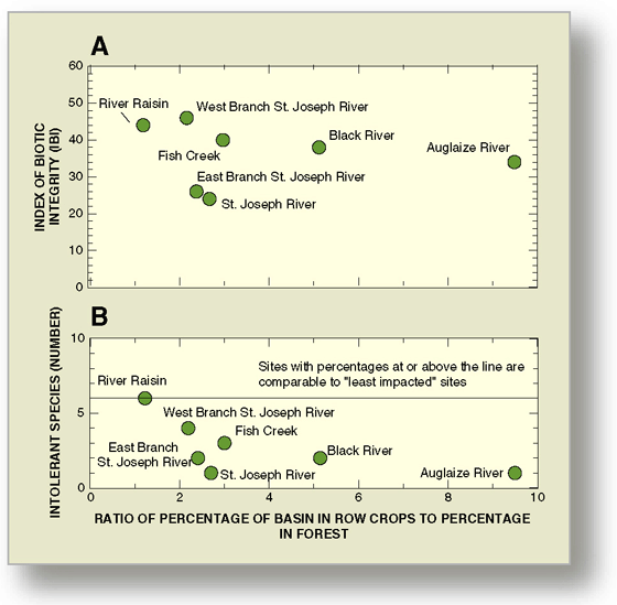 |
| Figure 25. As the percentage of row-crop land use increased in a stream basin (A) scores for the Index of Biotic Integrity decreased and (B) the number of pollution-intolerant fish decreased. |
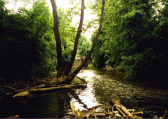
Although only a few sites were examined, it appears that pollution-intolerant fish can live in streams where agriculture is the primary land use under certain conditions. This information corroborates the findings of others on the water-quality benefits provided by undisturbed natural stream habitats and wooded riparian areas (figs. 26 and 27).
 |
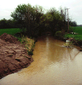 |
| Figure 26. High-quality stream habitat supports a variety of pollution-intolerant fish species along the West Branch of the St. Joseph River. | Figure 27. Poor-quality stream habitat supports pollution-tolerant fish along the East Branch of the St. Joseph River. |
Recent residential development has had a widespread effect on ground-water quality
Two studies were done to assess ground-water quality in areas west of Detroit, where recent suburban development overlies sand-and-gravel deposits (Thomas, 2000a). Recent suburban development typically consists of homes on large residential/rural lots or in upper-middle-class subdivisions (fig. 28). Most homes have private wells, septic systems, and water softeners.
 |
| Figure 28. Much of the recent development west of Detroit in the residential study area consists of low- to medium-density subdivisions. Most homes have private wells, septic systems, and water softeners. |
Samples of shallow and deep ground water were collected from co-located wells (fig. 29). Shallow ground water was sampled from 30 monitor wells (median depth of 25 feet). Deeper ground water was sampled from 28 domestic wells (median depth of 93 feet). In most places, clay till of varied thickness separates the shallow and deep sand-and-gravel deposits (fig. 29).
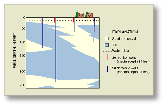 |
| Figure 29. Ground-water samples were collected from pairs of shallow monitor wells and deeper domestic wells. Sand-and-gravel deposits are at land surface and at varied depths in the subsurface. |
Tritium concentrations were used to distinguish ground waters recharged before 1953 (“old waters”) from those recharged after 1953 (“young waters”) (Plummer and others, 1993). Water in about one-third of domestic-wells was recharged before 1953, which is prior to widespread residential development in the study area. Old waters show no evidence of human activities. All nitrate concentrations were less than the estimated background value of 2 mg/L (U.S. Geological Survey, 1999), and all chloride concentrations were less than 25 mg/L, the estimated background concentration based on a historical data set from the same area (Mozola, 1953).
In contrast, more than 75 percent of young waters show evidence of human influence:
Seventy-six percent of young waters had chloride concentrations greater than background (fig. 30). Probable sources of elevated chloride concentrations are road salt, septic systems, and backwash from water softeners.
- Twenty-six percent of young waters contained nitrate concentrations greater than background (fig. 30). Probable sources of elevated nitrate concentrations in residential areas are septic systems, lawn fertilizer, and pet waste.
- Trace concentrations of VOCs were detected in 29 of the 30 samples from monitor wells. The most frequently detected VOCs were BTEX compounds, which are components of fuels and solvents.
Samples that contained nitrate or VOCs also contained elevated chloride concentrations. The co-occurrence of these compounds suggests that ground water is affected by a mixture of sources, such as (1) septic systems containing domestic waste (nitrate and chloride), water-softener backwash (chloride), and/or household solvents such as drain cleaners (VOCs), (2) infiltration of runoff from roads containing road salt (chloride) and fuel residue (VOCs), and/or (3) fertilizer or pet waste (nitrate) from lawns.
Pesticides were detected infrequently. Trace concentrations of herbicides were detected in 2 of 30 (7 percent) monitor-well samples. This value is low compared to similar studies in 25 other urban/residential areas, where the median detection frequency of herbicides in shallow ground water was 44 percent (Kolpin, 2000). In the study area, most of the pesticides commonly used on lawns and roadways were analyzed for but were not detected in the shallow ground water.
One monitor-well sample had a nitrate concentration exceeding health-related standards (fig. 30). The sample was from a well too shallow to be used as a source of drinking water, but shallow ground water can migrate to deeper parts of ground-water system or discharge to streams, lakes, and wetlands.
No health-related drinking-water standards were exceeded in samples from domestic wells; however, standards do not exist for all compounds or for mixtures of compounds. Also, all possible constituents were not tested; for example, septic systems can contain bacteria, viruses, or pharmaceuticals.
In Michigan, the minimum depth required for domestic wells is 25 feet. In the study area, the effects of human activities were detected far below this depth (fig. 30). A proposal to increase the required depth for private wells in subdivisions is under consideration by the Michigan Department of Environmental Quality.
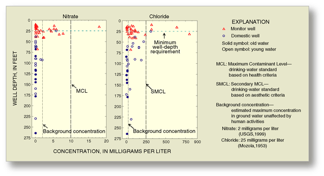 |
| Figure 30. In the residential study area, concentrations of nitrate and chloride greater than background concentrations are the result of human activities. Elevated concentrations of chloride were detected far below 25 feet, the minimum well depth required by State regulations. |
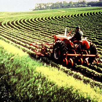 |
| Figure 31. In the agricultural study area, the predominant crops are corn, soybeans, and small grains. (Photograph from Ohio Department of Natural Resources.) |
Ground water is vulnerable to contamination in agricultural areas underlain by till
Ground-water quality was assessed in agricultural areas in the northwestern part of the Lake Erie-Lake Saint Clair Drainages (Thomas, 2000b) (fig. 31). In this region, clay-rich till is at the land surface, and the rate of water infiltration is generally less than in the residential study area, where sand and gravel are at the surface (compare figs. 29 and 32).
Samples of shallow ground water were collected from 30 monitor wells installed in the till at a median depth of 18 feet. Deeper ground water, from the glacial sand-and-gravel aquifer, was collected from 18 domestic wells with a median depth of 90 feet (fig. 32).
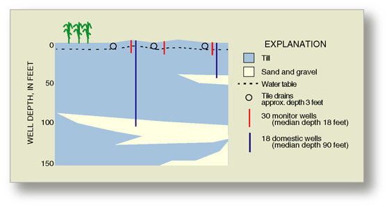 |
| Figure 32. In the agricultural study area, clay-rich till occurs at land surface. Shallow tile drains are installed in low spots of farm fields to improve drainage. |
Samples were analyzed for pesticides in the form of parent compounds (the original active ingredient) and metabolites (breakdown products). Pesticides were detected in 41 percent of monitor-well samples. The six compounds detected closely correspond to those most heavily applied in the basin—herbicides used on corn and soybeans (fig. 33). Metabolites were detected three times more frequently, and at higher concentrations, than were parent compounds. Concentrations did not exceed drinking-water standards, but standards do not exist for 9 of the 11 compounds detected. In addition, many samples contained more than one herbicide, and the health effect of mixtures is unknown.
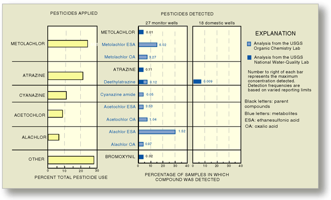 |
| Figure 33. Pesticides detected in the shallow ground water closely correspond to those most heavily applied in the Lake Erie–Lake Saint Clair Drainages (data from Brody and others, 1997). All are herbicides used on corn and soybeans. Metabolites were detected more frequently, and at higher concentrations, than parent compounds. |
Nitrate concentrations indicative of human influence were detected in 37 percent of monitor-well samples. Probable sources are nitrogen fertilizers (which are heavily used in the study area), manure, or septic systems. Nitrate concentrations exceeded health-related drinking-water standards in two shallow monitor wells (fig. 34).
Pesticides and nitrate were detected much less frequently in domestic wells than in monitor wells (fig. 34). About 6 percent (1 of 18) of samples from domestic wells contained a trace concentration of a pesticide metabolite, and 6 percent contained a nitrate concentration approximately equal to the background concentration of 2 mg/L.
A common belief is that till protects the ground water from contamination. There appears to be some truth to this idea because detections of nitrate and herbicides are low relative to other agricultural areas with similarly high application rates. At the same time, this belief is a simplification that may be misleading because ground water is still vulnerable to contamination, especially at shallow depths.
Fifty-nine percent of monitor-well samples showed evidence of human activity—either an herbicide or an elevated nitrate concentration. Moreover, 83 percent of waters from monitor wells were recharged after 1953. These observations indicate that till does not prevent water at the land surface from moving to the shallow ground water. In the study area, till contains vertical fractures and numerous stringers of sand and gravel that are potential pathways for movement of water from the surface. In areas with similar geology to that in the agricultural study area, active ground-water flow occurs to depths of 35 feet, and sometimes much deeper (Keller and others, 1991).
Similarly, till does not completely prevent water at the land surface from entering the deeper ground water. Eleven percent of domestic-well samples contained either a pesticide or elevated nitrate concentration. Moreover, almost half of the waters from domestic wells between depths of 35 to 100 feet were recharged after 1953 (fig. 34).
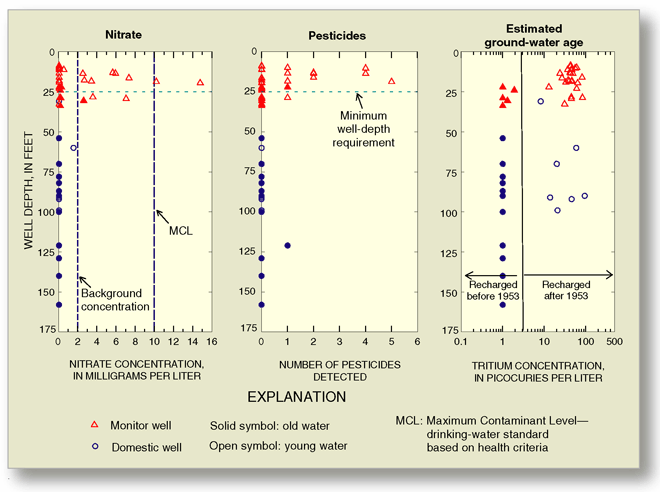 |
| Figure 34. Detections of nitrate or pesticides are relatively infrequent at depths greater than 35 feet; however, deeper ground water is not completely isolated from the land surface because almost half of the waters between depths of 35 and 100 feet were recharged after 1953. |
Naturally occurring geochemical processes may be partly responsible for the relatively low detection frequencies of agrochemicals in the ground water. Till and till soils are generally rich in clay and organic matter and therefore are conducive to the sorption or breakdown of pesticides. Most of the pesticides detected were metabolites that had already been partially broken down (fig. 33).
Nitrate also can be transformed in the subsurface. In the presence of organic matter, low dissolved-oxygen concentrations are conducive to denitrification. Ground-water samples from 100 percent of the domestic wells and 50 percent of the monitor wells had dissolved-oxygen concentrations less than 1 mg/L. In addition, the till contains numerous fragments of black shale rich in pyrite, a mineral that can also lead to denitrification (Robertson and others, 1996).
Within the study area, the thickness and composition of the till are variable and not well defined in all locations. Therefore, the degree to which the till protects the ground water—by physical or geochemical means—is probably also variable and difficult to predict.
Low detections of agrochemicals in ground water may be partly due to tile drains, which can divert contaminants from the shallow ground water to streams (Nolan and Stoner, 2000), but tile drains do not completely prevent contaminants from reaching shallow ground water. Nitrate and pesticides were detected in monitor wells 10 to 34 feet deep, whereas tile drains are typically about 3 feet deep. Vertical fractures in the till can provide a direct pathway from the land surface to the water table.
 |
In general, agrochemicals are most
frequently detected where they are most heavily used; but exceptions
to this pattern have been found (U.S. Geological Survey, 1999). For
example, in the agricultural study area, detections of nitrate and
herbicides in shallow ground water are among the lowest in the Nation
even though nitrogen inputs and herbicide use are among the highest.
In deeper ground water, nitrate and herbicide detections are also
low relative to the Nation as a whole. A similar phenomenon has been noted elsewhere. In parts of the Midwest, the proposed explanations for low detections of nitrate in ground water are that (1) till impedes movement of contaminants from land surface, or (2) tile drains divert contaminants to streams (Fenelon, 1998; Nolan and Stoner, 2000). In an area of the Southeast Coastal Plain, biogeochemical processes are the proposed cause of the low detections (Nolan and Stoner, 2000). In the study area, low detections of nitrate (and herbicides) are probably due to a combination of physical and geochemical processes. |

| Table of Contents || Previous Section || Next Section || Glossary U.S. Geological Survey Circular 1203 Suggested citation:
|
