
STUDY UNIT DESIGN
Studies in the KanawhaNew River Basin were designed to describe the general quality of water and the aquatic ecosystem and to relate these conditions to natural and human influences (Gilliom and others, 1995). The design focused on the principal environmental settingscombinations of geohydrology, physiography, and land usethroughout the basin. The studies supplement assessment work by State agencies (Virginia Department of Environmental Quality, 1998; North Carolina Department of Environment and Natural Resources, 1999; West Virginia Division of Environmental Protection, 2000).
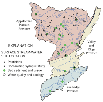
| Stream Chemistry and Ecology The sampling network was designed to characterize the effects of land use on stream quality at various scales. Water chemistry, fish and invertebrate communities, habitat, and bed-sediment and fish-tissue chemistry were used as indicators of stream quality. Fixed Sites were chosen on large rivers at the boundary between the Valley and Ridge and Appalachian Plateaus Physiographic Provinces, downstream from the Greenbrier and Gauley Rivers, and near the mouth of the Kanawha River. Fixed Sites also were chosen on tributaries to represent the effects of agriculture, coal mining, forest, and a relatively large human population in an otherwise rural setting. |
 |
|
|
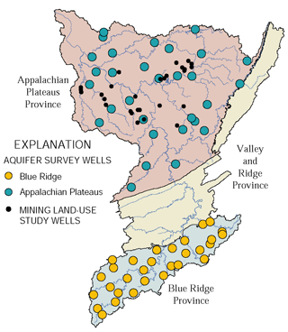
Ground-Water Quality The ground-water network was designed to broadly characterize the resource. Little previous information was available in the aquifer-survey areas. Aquifer surveys examined more constituents than any previous study and included a random component in site selection that allows estimates to be made for the whole population of similar wells. The land-use study targeted current effects of mining reclamation standards that have developed since around 1980. |
| Study |
What data were collected and why |
Types of sites sampled |
Number |
Sampling
|
|---|---|---|---|---|
| STREAM CHEMISTRY AND ECOLOGY |
||||
|
Fixed sites-- |
Concentration, seasonal variability, and load of major ions, common metals, nutrients, bacteria, organic carbon, dissolved oxygen, suspended sediment, pH, specific conductance, and temperature. Continuous streamflow monitoring. |
Large rivers with mixed land use, draining 3,700 to 11,800 square miles at sites located between major tributaries or at boundaries of regional environmental settings. |
4 |
Monthly plus storms: about 30 samples during October 1996 through September 1998. |
|
Tributary streams draining 40 to 300 square miles in basins with predominant land uses of agriculture, coal mining, forest, and rural residential. |
7 |
|||
|
Fixed sites-- |
Concentration and seasonal variability of 86 organic compounds in addition to the general water-column constituents listed above. |
One large river downstream from the Valley and Ridge Physiographic Province and one near the mouth of the Kanawha River. |
2 |
Semimonthly to monthly; 14 or 15 samples in 1997. |
|
Tributary streams with extensive agricultural land use. |
2 |
Weekly to monthly during 1997; 9 or 25 samples. |
||
|
Fixed sites-- |
Fish, benthic invertebrate, and algae communities were sampled and physical habitat was described to determine the presence and community structure of aquatic species. |
Fixed sites where general water-column samples were collected. |
11 |
Once, in 1997; three reaches sampled at each of three tributary sites in 1998. |
|
Contaminants in fish tissue |
To determine the presence of potentially toxic compounds in food chains that can include humans. Data included 22 elements and 28 organic compounds. Samples were a composite of at least five fish from one species, usually rock bass or common carp. |
Fixed sites where general water-column samples were collected, plus contrasting settings in three large basins with mixed land use and five tributaries. |
19 |
1 or 2 samples per site and species, during 1996 or 1997; 27 total samples. |
|
Contaminants in bed sediment |
To determine the presence of potentially toxic compounds attached to sediments accessible to aquatic life. Data included 44 elements and more than 100 organic compounds. |
Same as sites for contaminants in fish. Composite samples were collected from depositional zones, where fine-grained sediments transported within the past year settle out of the water. |
19 |
1 or 2 samples during 1996 or 1997; 21 total samples. |
|
Synoptic sites-- |
To assess the present effects of coal mining in Appalachian Plateaus streams and the change in stream chemistry since about 1980. Data included discharge, alkalinity, acidity, pH, specific conductance, sulfate, chloride, and dissolved and total iron, manganese, and aluminum. Coordinated with a similar study in the Allegheny-Monongahela study unit. |
Streams draining 0.2 to 128 square miles in areas of known mining history, including unmined basins. Most of the sites were sampled for water-column chemistry during 1979-81. |
57, including 3 Fixed Sites |
One sample during low flow, July 1998. |
|
Benthic invertebrate community, physical habitat, contaminants in bed sediment, and other major ions in addition to constituents listed above. |
A subset of sites described above, draining 8.8 to 128 mi². |
30 |
||
|
Fish community, in addition to constituents listed above. |
A subset of benthic invertebrate sites. |
10 |
||
| GROUND-WATER |
||||
|
Aquifer Surveys- |
General water quality, to determine the occurrence and distribution of contaminants. Data included major ions, nutrients, bacteria, organic carbon, 19 trace elements, 47 pesticides, 86 volatile organic compounds, dissolved oxygen, turbidity, pH, specific conductance, and temperature. Samples from the Blue Ridge were analyzed for an additional 39 pesticides. |
Domestic and public supply wells 25 years old and younger, and in good condition. |
60 |
Once in 1997. |
|
Land-use effects, reclaimed surface coal mines |
General water quality, to determine effects of present reclamation requirements. Data included the constituents from aquifer surveys, without pesticides or volatile organic compounds. Coordinated with a similar study in the Allegheny-Monongahela Study Unit. |
Domestic wells within 3,100 feet downgradient from a fully reclaimed surface coal mine. Reclamation was complete between 2 and 12 years before sampling. None of the sites were near "mountaintop removal" mines. Included both old and new wells. |
28, |
Once in 1998. |
| Table of Contents || Previous Section || Next Section || Glossary U.S. Geological Survey Circular 1204 Suggested citation:
|
