
INTRODUCTION TO THE SANTEE RIVER BASIN AND COASTAL DRAINAGES
The Santee River Basin and coastal drainages includes about 24,000 square miles in North and South Carolina. The Santee River has the second largest drainage area in the Eastern United States, and its basin makes up 70 percent of the study area. The basins of the Cooper, Edisto, and numerous smaller rivers make up the remainder of the study area.Throughout this report, the study area, including these smaller river basins, will be collectively referred to as the Santee Basin.
Physiography and Water Quality
The rugged mountains of the Blue Ridge physiographic province are sparsely populated. Land-use effects on water quality are minimal because the area is largely undeveloped. Consequently, the Blue Ridge has more pristine water quality and intact stream ecosystems than other parts of the study area.
The rolling hills and abundant water resources of the Piedmont have attracted industrial development and human population growth. Many of the areas experiencing urban growth are in the Piedmont, near the headwaters of rivers that supply drinking water and also receive treated waste water. Since flows in these headwater streams are smaller than they are farther along the stream courses, they have a limited capacity to assimilate large quantities of wastewater and nonpoint-source inputs from the urban areas.
The flat-lying topography and fertile soils of the Coastal Plain are ideal for agricultural use. Development for shipping, industry, and tourism is mostly limited to land within a few miles of the coast. Most of the Coastal Plain is characterized by slow-moving, low-gradient streams that commonly are bordered by extensive swamps (Smock and Gilinsky, 1992). The combination of slow-moving water and large quantities of organic matter in the swamps results in a characteristically dark-colored water called blackwater. Under natural conditions, blackwater streams have low pH and contain low concentrations of dissolved oxygen. These conditions can make the stream particularly susceptible to water-quality degradation by the contribution of oxygen-consuming chemicals in wastewater discharge or nonpoint contamination.
The Santee Basin has a rapidly growing population of about 3.5 million people. Most of the people live in the urban areas of Charlotte, N.C., and Greenville-Spartanburg, Columbia, and Charleston, S.C. (fig. 1). The most common types of urban development are commercial and residential.
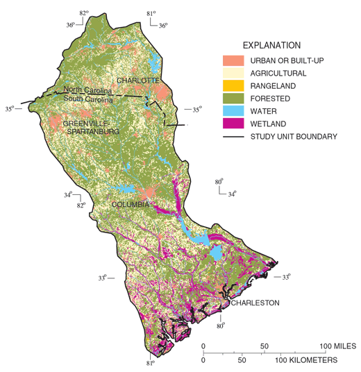 |
| Figure 1. Land use in the Santee Basin includes about 60 percent forested, 30 percent agricultural, and 6 percent urban lands. |
As urban areas develop, increased use of pesticides and fertilizers on lawns and landscaped areas can lead to increased concentrations of these chemicals in ground and surface waters. Commercial and residential use of solvents and fuel products can result in their introduction to ground and surface water through accidental spills or leaking storage tanks. Bacteria and nutrients can enter water through leaking sewer lines, malfunctioning septic tanks, and from runoff of pet and waterfowl wastes. Although thoroughly regulated, discharges from wastewater treatment plants increase as population grows, increasing the loading of nutrients to streams.
Agriculture is an important economic activity throughout the Santee Basin. Row crop agriculture is most common in the Coastal Plain, where corn, soybeans, and cotton are the most common crops (South Carolina Agricultural Statistics Service, 1999). Pasture for hay and for grazing cattle is typical of agricultural land in the Piedmont. These agricultural activities can result in elevated nutrient and pesticide levels in streams and ground water from runoff or infiltration of manure, fertilizer, or pesticides.
Most of the land in the Santee Basin is forested. Forests range from largely unaltered hardwoods in the Blue Ridge and mixed pine and hardwood stands in the Piedmont to intensively managed pine plantations and forested wetlands in the Piedmont and Coastal Plain. Trees are commercially harvested in all of these areas, producing various levels of soil disturbance, erosion, and increased sediment loads in the streams.
Climate Conditions and Water Quality
|
| Figure 2. Precipitation affects water quality by producing runoff to streams and infiltration to aquifers. |
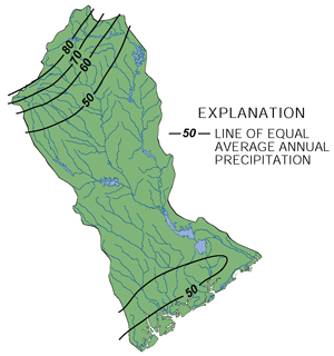
The major climatic factors affecting water quality are seasonal and areal distributions of precipitation. The amount of rainfall affects water quality because areas with higher rainfall generally have greater runoff and more infiltration to ground water. However, increased flows also can help to dilute concentrations of chemicals in ground water and surface water. The distribution of rainfall in the Santee Basin is fairly uniform except for very high precipitation in the Blue Ridge (South Carolina Water Resources Commission, 1983; fig. 2).
Seasonal variability of rainfall also is important. Generally the highest concentrations of pesticides in streams occur when rainfall immediately follows pesticide applications. Rainfall is highest in spring and summer, typically when agricultural and residential lawn pesticides are applied.
Rainfall also is important because it contains nutrients and metals that contribute to concentrations of these compounds in surface water. Atmospheric deposition accounts for the majority of ammonia and nitrate nitrogen in streams (Maluk and others, 1998). A study also has suggested that mercury contamination in the Santee Basin results from atmospheric deposition (Krabbenhoft and others, 1999).
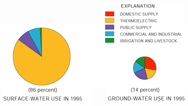 |
| Figure 3. Most water used in the Santee Basin is supplied by surface water. Ground water is important because it is the major source of domestic water supply in rural areas. Relative size of pie charts represents relative percentage water use. |
Most of the 7 billion gallons of water used each day in the Santee Basin is surface water (fig. 3). About 85 percent of this water is used in the production of electricity, and the remainder is used for public water supplies, commercial and industrial uses, irrigation of crops, and watering livestock.
Ground water accounts for only about 14 percent of total water use but is a very important resource. Private domestic wells are the only viable sources of water in areas not served by public water supplies.
Flow Regulation, Impoundments, and Surface-Water Quality
The regulation of flow in the Santee Basin has altered the historical seasonal flow patterns in the rivers. High peak flows and extreme low flows downstream from major reservoirs generally are less common than they were prior to construction of the reservoirs. The alteration of flow primarily affects the physical habitat of the rivers and also can affect stream temperature. Populations of aquatic organisms are altered due to changed conditions in the streams downstream from reservoirs. For example, cold water discharged from the bottom of Lake Murray makes it possible for trout to survive nearly 100 miles beyond their normal range.
Reservoirs are especially affected by stream chemistry because they trap sediment and the phosphorus that attaches to the sediment. This trapping process can cause lakes to become eutrophic, or nutrient enriched, and cause algal blooms. Occasionally, fishkills result when the artificially large algal population dies and the dissolved oxygen, which is necessary for fish survival, is consumed during the decaying process. Of 11 major lakes in the study area, 9 contained areas with excessive nutrients, extremely high productivity and were susceptible to nuisance macrophyte growth and algal blooms (Stecker and Crocker, 1991).
Aquifer Characteristics and Ground-Water Quality
Shallow ground water (generally less than 50 feet below land surface) is vulnerable to contamination in much of the Santee Basin. Fertilizers, pesticides, and spills or leaks of chemicals at or near the land surface can move rapidly to the water table. Areas with sandy soils are particularly susceptible to contamination because these coarse-grained soils allow rapid transport and provide little opportunity for filtration or degradation of contaminants. Sandy soils typically are present in parts of the Coastal Plain and to a lesser degree in the Piedmont.
Deep aquifers also can be susceptible to contamination, depending on their degree of connection to the surface. The Piedmont, Sandhills, and Floridan aquifers supply most of the ground water in the Santee Basin (fig. 4). Ground water in the Piedmont aquifer occurs in fractures or cracks in the hard crystalline bedrock. In most areas, the bedrock is overlain by clay soils of variable thickness. Sandhills aquifers are unconfined; that is, they have no clay layer above them to inhibit the downward movement of contaminants to the aquifer. The Floridan aquifer is confined toward the coast but is unconfined farther inland. Of the three aquifers, the Sandhills aquifer is the most susceptible to contamination because of its sandy soils and lack of confinement. The Floridan aquifer, near the coast, is the least susceptible because it is confined.
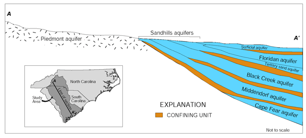 |
| Figure 4. Aquifers sampled in the Santee Basin include the surficial, Piedmont, Sandhills, and Floridan aquifers (modified from Aucott and others, 1987). The Black Creek, Middendorf, and Cape Fear aquifers are not used much in the study area because of the cost of drilling deep wells and poor water quality. |
| Table of Contents || Previous Section || Next Section || Glossary U.S. Geological Survey Circular 1206 Suggested citation:
|