
INTRODUCTION TO THE MISSISSIPPI EMBAYMENT
 |
| John James Audubons painting of the peregrine falcon that he worked on while visiting the Yazoo River area in 1821. (Reprinted courtesy of the National Audubon Society.) |
In 1821, while painting a peregrine falcon, John James Audubon described the Yazoo River, the largest river wholly contained within the Mississippi Embayment Study Unit, as a beautiful stream of transparent water, covered by thousands of geese and ducks and filled with fish (Smith, 1954). Since that time, the bottomland hardwood forests that covered the Mississippi River Alluvial Plain have been cleared for agricultural use of the rich alluvial soils for the production of cotton, soybeans, rice, and corn. This clearing of the land has exposed the fine alluvial soils to erosion. Over time, the clays, along with nutrients and agricultural chemicals sorbed to the clay surfaces, were washed into the rivers and streams, thus greatly changing the water quality of the area.
Physiography and Ecoregions
Within the Mississippi Embayment (MISE) Study Unit, the surficial geology is the underlying controlling factor for the physiography, land use, biological communities, and water quality of the area. Therefore, the areas defined as physiographic regions (Fenneman, 1938) strongly correspond to the related ecoregions defined by Omernik in 1987 (fig. 1).
About 57 percent of the MISE Study Unit lies within the Mississippi Alluvial Plain physiographic province and ecoregion. This area has been dominated by the flow and flooding of the Mississippi River during the past 2 million years or more. The Mississippi Alluvial Plain is an area of little topographic relief with an average slope of about 0.5 foot per mile toward the Gulf of Mexico. One of the distinct features of the alluvial plain is the formation of natural levees along the banks of the rivers, and the associated backswamp deposits that are dominated by dense alluvial clays and historically have supported extensive wetland areas. These clays have created low permeability soils, which limit the ability of rainwater to infiltrate the ground surface and may cause runoff from agricultural fields to rapidly enter rivers and streams. These clays also seem to limit the susceptibility of the ground water to surface activities in intense agricultural areas.
 |
|
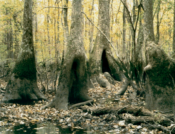
| Much of the Mississippi Embayment Study Unit was bottomland hardwood forests and wetlands well into the 20th century. |
Thirty-five percent of the remainder of the Study Unit lies in the Gulf Coastal Plains physiographic province, which includes the area identified as the Mississippi Valley Loess Plains and Southeastern Plains ecoregions (fig. 1). The Gulf Coastal Plains are separated from the eastern edge of the Mississippi Alluvial Plain by the Loess Hills, which extend most of the length of the Study Unit. These hills are made of wind-blown silts, rise a few hundred feet above the Mississippi Alluvial Plain, and average about 15 miles in width. The remaining part of the Gulf Coastal Plains uplands and Southeastern Plains ecoregion generally is rolling to hilly with low to moderate topographic relief. The soils are composed, in part, of silts and are more permeable than the alluvial clays; there are indications that this allows for the downward infiltration of precipitation. This may partly protect the streams and rivers from compounds carried in runoff but may make the ground water slightly more susceptible to surface contamination. These coarser soils on steeper slopes are more erodible than alluvial soils, and large amounts of soil from the Gulf Coastal Plains uplands have eroded into the Mississippi Alluvial Plain.
In the west, the Study Unit abuts small areas of the Ozark Highlands. Limited sampling was done in these areas during this project. The land surface generally slopes toward the Mississippi River from both the eastern and western sides of the Study Unit and to the south toward the Gulf of Mexico. Thus, nearly all of the activities in this Study Unit that influence water quality ultimately influence the water quality of the Mississippi River and the Gulf of Mexico.
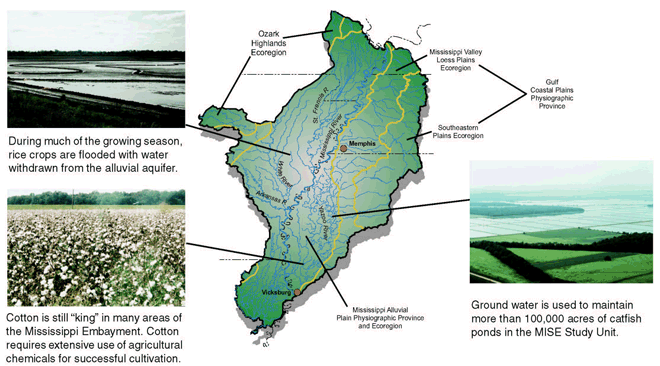 |
| Figure 1. Boundaries for Fennemans (1938) physiographic regions are very similar to Omerniks Level III ecoregions (1987), at least in part because the surficial geology is a controlling factor in the MISE Study Unit. The only major metropolitan area in the Study Unit is Memphis, Tennessee. The area has many rivers, as well as several large river systems, including the Yazoo and St. Francis Rivers and parts of the White and Arkansas Rivers. Major crops include soybeans, cotton, rice, and corn. Catfish farms are a major component of the landscape as well as a principal user of ground water. |
Geology
The Mississippi Alluvial Plain is in the northern part of the Mississippi Embayment, a geologic structural trough in which the underlying crust of the Earth forms a deep valley. Large rivers, such as the Mississippi, Arkansas, and Ohio Rivers, have flowed through this region, carved the surface, and deposited clay, silt, sand, and gravel, collectively called alluvium. During the past 2 million years, up to 300 feet of alluvium has filled this valley. The alluvium can be grouped into three major units: the Pleistocene Prairie Complex, Pleistocene valley trains, and the Holocene alluvium (see fig. 7 for map; Autin and others, 1991; Saucier, 1994).
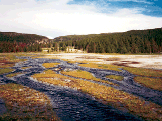
The Prairie Complex is older than the Pleistocene valley trains and the Holocene alluvium. Saucier (1994) suggested that the Prairie Complex was deposited between about 120,000 years ago and the time of the greatest extent of the last glacier, about 18,000 years ago. The Pleistocene valley trains were mostly deposited during two time periods, between about 60,000 and 25,000 years ago and during the waning phase of the latest glacial period between 18,000 and 10,000 years ago. Glacial outwash (melting) flowing from north to south provided enough energy to cause a braided stream depositional environment to form in the Lower Mississippi River Valley during this time. By about 9,000 years ago, the rate of glacial outwash in the Lower Mississippi River Valley declined, and valley train deposition ceased. The braided stream depositional process of the Pleistocene epoch was replaced by the lower energy meander stream depositional process of the Holocene epoch near major rivers, such as the Mississippi and Arkansas Rivers. (See fig. 2 for more explanation.) Autin and others (1991) reported that the depositional transition from Pleistocene valley trains (braided streams) to Holocene alluvium (meander streams) started near Baton Rouge, Louisiana, around 12,000 years ago and migrated northward to near Cairo, Illinois, by 9,000 years ago.
The Pleistocene valley train deposits generally have a coarser grain size than the Holocene alluvium. Also, water well drillers logs indicate that the clay and silt layer near the surface is thicker in the Holocene alluvium, whereas the underlying sand and gravel layer (alluvial aquifer) is thicker in the Pleistocene valley train deposits.
 |
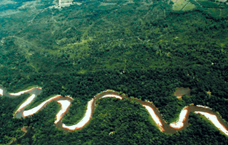 |
| Figure 2. Although the photograph on the left was recently taken of a stream in the Western United States, its braided condition is representative of what streams in the Mississippi Valley may have looked like during the Pleistocene geologic period. These high-energy systems allow sand and gravel carried by the stream to be deposited in the flood plain. The photograph on the right depicts a classic meandering stream. Streams like this are low-energy systems and primarily deposit clay, silt, and fine sand in the flood plains adjacent to the streams. This depositional pattern is present today and has been the dominant form of deposition in the Lower Mississippi River Valley during the last 9,000 to 12,000 years. These differences in depositional environments appear to influence the chemistry of the ground water, the bioaccumulation of pesticides, and biological communities. | |
Hydrogeology
Two principal aquifer systems provide drinking-water supplies in the Mississippi Embaymentthe Tertiary and the alluvial aquifers (fig. 3).
Tertiary Aquifers
The geologic groups associated with the deep Tertiary aquifers are the Midway, Wilcox, Claiborne, and the Jackson groups. The deep Tertiary aquifers sampled in this study are thick sand deposits within the Wilcox and Claiborne groups. The names of the aquifers, from youngest to oldest, include the Cockfield, Sparta, Winona-Tallahatta, Memphis, Meridian-upper Wilcox, and Wilcox.
The natural regional flow of ground water in the Mississippi Embayment in the Tertiary aquifers is from the outcrop areas in the upper Gulf Coastal Plain, laterally along the aquifers toward the embayment axis, and then upward through overlying confining units and aquifers to the surface of the Mississippi Alluvial Plain (Grubb, 1986; Ackerman, 1989). Pumping in the deep Tertiary aquifers has caused recharge rates to increase in the outcrop and production areas of the aquifer (Williamson and others, 1990).
Alluvial Aquifers
The Mississippi River confining unit is composed of the upper silt and clay of the Quaternary alluvium, whereas the Mississippi River alluvial aquifer is composed of the lower sand and gravel of the Quaternary alluvium (Boswell and others, 1968; Ackerman, 1989). Overlying silt and clay of the confining unit impedes recharge into the alluvial aquifer. Confining unit thickness generally ranges from 10 to 50 feet and generally increases from north to south within the MISE Study Unit. The thickness of the alluvial aquifer ranges from 60 to 140 feet. Wells screened in the alluvial aquifer typically yield between 1,000 and 2,000 gallons per minute (Whitfield, 1975). Prior to development, ground-water flow is believed to have been generally from the older adjacent and underlying aquifers toward the alluvial aquifer (Williamson and others, 1990).
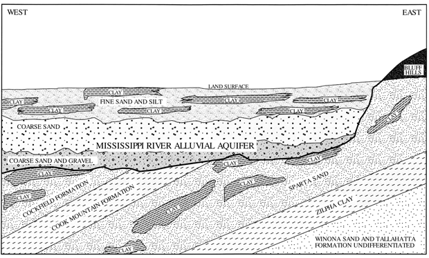 |
| Figure 3. Generalized geohydrologic section of the Mississippi River alluvial aquifer and underlying Tertiary aquifers (from Arthur, 1994). |
Climate
Climate in the MISE Study Unit varies from humid, temperate in the northern part to humid, subtropical in the southern part. This warm climate results in a long growing season and few killing frosts, which influences the types of crops that can be grown and the amount of pesticides that generally are applied. Mean annual precipitation ranges from about 48 inches per year in the northern part of the Study Unit to 56 inches per year in the southern part. Precipitation generally is greatest in April and least in October but is distributed fairly evenly throughout the year. This causes minor drought conditions to occur frequently during the summer, when the evapotranspiration rate is higher than the precipitation rate. These conditions also result in streams which flood rapidly, remain at high levels for long periods of time, and have low flows in the fall (fig. 4).
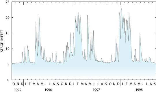 |
| Figure 4. This hydrograph is representative of streams in the Mississippi Alluvial Plain. Often streams in this Study Unit flood rapidly, remain at high levels for long periods, and have very low streamflows in the fall. During the years of this project, 1996 was drier than usual, and 1997 and 1998 were wetter than usual. |
Water Use
In general, about three times as much ground water is used compared to surface water in the MISE Study Unit (fig. 5). During the summer months, both ground and surface water are used for irrigating crops. Most (in excess of 7 billion gallons per day) of the irrigation water is withdrawn from the alluvial aquifer. This aquifer is also used for domestic drinking water, aquaculture (primarily for catfish ponds), power production, and other commercial and industrial needs. Ground water, primarily from the Tertiary aquifers, is used for public supply. The principal use of surface water is for power production where it is used for cooling water for electric power generation. The second largest use of surface water is for irrigation.
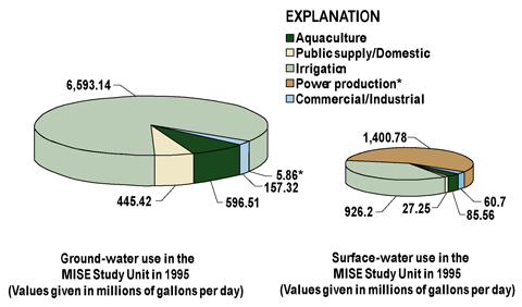 |
| Figure 5. Ground-water use in the Mississippi Embayment (MISE) Study Unit is dominated by irrigation usage. Surface water is also used for irrigation, but more is used for cooling water for electrical power production. |
| Table of Contents || Previous Section || Next Section || Glossary U.S. Geological Survey Circular 1208 Suggested citation:
|
