STUDY UNIT DESIGN
 |
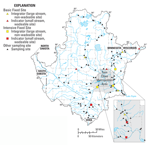
During 1996–98, about 4,200 water-quality aquatic-biological samples from about 240 sites were collected in the Study Unit, processed, and analyzed, using nationally consistent protocols and methods (Gilliom and others, 1995). The NAWQA design included physical, chemical, and aquatic-biological aspects of surface water and ground water for the entire Study Unit. Six sampling components were included in the sampling design. Each component involved measurements of water-quality or aquatic biological characteristics at one or more spatial or temporal scales. Three of the sampling components addressed surface water and aquatic biology, and three addressed ground water. A detailed description of the design and implementation of these water-quality studies is contained in Stark and others (1999).
Water quality in streams was assessed through water-chemistry and aquatic-biological studies. The surface-water and aquatic biology components included (1) stream sites that integrate multiple land uses and encompass large watersheds (integrator site network), (2) stream sites that indicate homogeneous and more specific land uses (indicator site network), and (3) stream sites sampled for special studies (synoptic surveys).
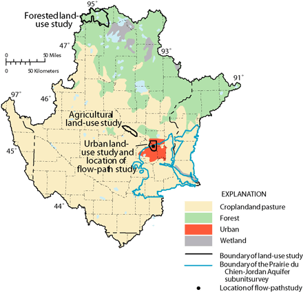
Ground-water quality was assessed for aquifer/land-use combinations using three sampling strategies: (1) a regional study of a selected major aquifer (subunit survey), (2) targeted-area studies in selected land uses (land-use studies), and (3) a localized study of processes occurring along shallow ground-water-flow paths (flow-path study). These studies and surveys emphasized shallow ground water, the quality of which is strongly affected by overlying land use and land cover.
 |
|
Study |
Purpose of component and types of data collected |
Types of sites sampled |
Number of sites |
Sampling frequency and period |
|---|---|---|---|---|
| Stream Chemistry |
||||
| Basic Fixed Sites-- large rivers |
Major ions, organic carbon, suspended sediment, nutrients, and streamflow were measured to describe concentrations and amounts of constituents transported in major tributaries in and from the Study Unit. |
Sites on the Mississippi, Minnesota, and St. Croix Rivers draining 1,510 to 46,800 mi² that integrate the effects of agricultural, urban, and forested land use and physiographic regions. |
4 in 1996-97; 3 in 1998 |
Monthly beginning in March 1996 and during selected runoff events |
| Basic Fixed Sites-- |
Major ions, organic carbon, suspended sediment, nutrients, and streamflow were measured to determine the effects of land use (undeveloped, urban, or agricultural) and surficial geology on stream-water quality. |
Streams draining 27.3 to 232 mi² of homogeneous agricultural, urban, or forested areas on unsorted or sorted surficial glacial deposits. |
3 in 1996; 2 in 1997-98 |
Monthly beginning in March 1996 and during selected runoff events |
| Intensive Fixed
Site-- |
Major ions, organic carbon, suspended sediment, nutrients, pesticides, and streamflow were determined to define short-term temporal variability. |
Sites on the Mississippi, Minnesota, and St. Croix Rivers draining 6,150 to 37,000 mi². |
3 |
Monthly beginning in March 1996 and during selected runoff events |
| Intensive Fixed
Site-- |
Major ions, organic carbon, suspended sediment, nutrients, pesticides, and streamflow were determined to define short-term temporal variability. Volatile organic compounds were determined at two urban sites. |
Streams draining 28.2 to 130 mi² in homogeneous agricultural and urban areas. |
3 |
Weekly or biweekly during April through August 1997 |
| Snowmelt synoptic survey |
Nutrients and suspended sediment were determined using modified NAWQA protocols to characterize instantaneous concentrations and yields during increasing streamflow of snowmelt runoff. |
Streams draining 10 to 46,800 mi². |
41 |
Once in March or April 1997 |
| Stream Ecology |
||||
| Bed sediment and tissue |
Trace elements and hydrophobic-organic compounds in fish tissue and streambed sediment to determine occurrence and distribution of these compounds throughout the Study Unit. |
Sites with drainage areas from 20 to 47,300 mi² draining a variety of land use. |
Fish sampled at 25 sites, streambed sediment at 27 sites. |
1995-96 |
| Basic Fixed Sites-- |
Fish, benthic invertebrates, phytoplankton, periphyton, and instream habitat were sampled or characterized to determine the community structure and to evaluate the association between land use and aquatic communities. |
Same as for stream chemistry |
6 in 1996; 5 in 1997-98 |
One each fall 1996-98 |
| Basic Fixed
Sites-- |
Fish, benthic invertebrates, phytoplankton, periphyton, and instream habitat were sampled or characterized to determine the spatial distribution of aquatic communities and to evaluate the association between land use and aquatic communities. |
Same as for stream chemistry |
7 |
One each fall 1996-98 |
| Urban synoptic study |
Nutrients, suspended sediment, pesticides, organic carbon, phytoplankton, and chlorophyll-a were analyzed. Aquatic community sampling included fish and invertebrate community sampling and instream habitat to determine how water quality and aquatic communities differ in response to changes in population density. |
Streams with drainage areas ranging from 9.9 to 152 mi² draining urban areas in the Twin Cities metropolitan area. |
13 |
September-October 1997 |
| Mid-continent agricultural synoptic study |
Nutrients, suspended sediment, pesticides, organic carbon, phytoplankton and chlorophyll-a were analyzed. Aquatic community sampling included fish and invertebrate community sampling and instream habitat characterization to determine how water quality and aquatic communities differ in response to changes in local-scale riparian cover and to basin-scale soils. |
Sites with drainage areas from 60 to 317 mi² draining land that was greater than 87 percent agricultural land use. |
24 |
August 1997 |
| Longitudinal synoptic study |
Nutrients, suspended sediment, major ions, pesticides, organic carbon, chlorophyll-a, and organic compounds indicative of wastewater were analyzed. Aquatic community sampling included fish and invertebrates and instream habitat to characterize the water quality and aquatic communities along the Mississippi River. |
Sites with drainage areas ranging from 32 to 46,800 mi² along the Mississippi River main stem from Lake Itasca to Red Wing, Minnesota. |
Sampled aquatic communities at 12 sites and water chemistry at 19 sites. |
July and August of 1998 |
| Ground-Water Chemistry |
||||
| Bedrock aquifer
|
Major ions, nutrients, dissolved organic carbon, trace elements, pesticides, volatile organic compounds, radon, and tritium were analyzed to describe the water quality and natural chemical patterns in unconfined and confined portions of the most frequently used bedrock aquifer in the Study Unit. |
Existing domestic wells completed in the Prairie du Chien-Jordan aquifer. |
25 wells
in the unconfined portion |
July-September 1996 |
| Land-use effects-- surficial aquifer |
Major ions, nutrients, dissolved organic carbon, pesticides, volatile organic compounds, and tritium were analyzed to determine the effects of specific land uses (urban, agricultural, and forested) on the quality of shallow ground water. |
Monitoring wells completed at the water table in the surficial sand and gravel aquifer. |
30 wells in the urban study |
June-July 1996, May-September 1998, June 1998 |
| Variations along flow-- surficial aquifer |
Major ions, nutrients, dissolved organic carbon, trace elements, pesticides, volatile organic compounds, radon, tritium, dissolved gases, and chlorofluorocarbons were analyzed to describe the effects of urban land use on the quality of shallow ground water along ground-water flow from an area of recharge to an area of discharge to a stream. |
Monitoring and multiport wells (open to the aquifer at different depths) completed in the surficial sand and gravel aquifer. |
1 monitoring well and 6 multiport wells |
July 1997, October 1997, August 1998 |
| Table of Contents || Previous Section || Next Section || Glossary U.S. Geological Survey Circular 1211 Suggested citation:
|

