
MAJOR FINDINGS
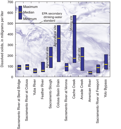 |
| Figure 6. Concentrations of dissolved solids at the fixed sites. The highest concentrations were measured at the agricultural, mining, and urban sites. (EPA, Environmental Protection Agency) |
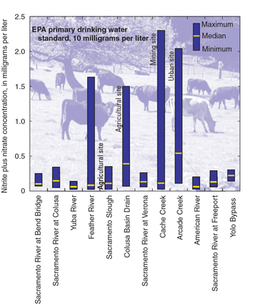
Water of the Sacramento River and its major tributaries is generally of good quality; the source is snow that melts and collects in upstream reservoirs and is released in response to water needs or flood control. The amount of dissolved solids in the Sacramento River and its major tributaries (Yuba, Feather, and American rivers) was low at all of the sampled locations (fig. 6). Higher median concentrations of dissolved solids occurred at agricultural sites such as the Sacramento Slough and Colusa Basin Drain, but those are diluted upon mixing with Sacramento River water (Domagalski and Dileanis, 2000). Nutrient concentrations such as nitrate also were low throughout the Sacramento River Basin (Domagalski and Dileanis, 2000) (fig. 7), and drinking-water standards for nitrate were not exceeded during the course of this study. At some locations, algae attached to streambed material was abundant, indicating that further investigation of nutrient dynamics and their consequences to the streams of this watershed is warranted. Excess algal growth, which is usually related to higher-than-normal nutrient inputs to streams, is a water-quality concern when the algae affect the aquatic community (because of dissolved oxygen depletion). No such effects were observed in the Sacramento River or its major tributaries. Excess algae also can contribute to taste and odor problems in drinking water.
|
| Figure 7. Concentrations of nitrite plus nitrate at the fixed sites. The highest concentrations were measured at the mining and urban sites. |
Some stream segments are listed as impaired by various contaminants (U.S. Environmental Protection Agency, accessed January 2, 2000). An impairment means that a standard of water quality for beneficial uses (for example, as a source of drinking water or for recreation or industrial use) is not being met. The impaired water bodies shown in figure 8 are mainly affected by nonpoint sources of contaminants from agriculture or from a combination of point and nonpoint sources from abandoned mines. Water-quality objectives are usually not met only during conditions of stormwater-driven runoff. The Clean Water Act requires States to maintain a listing of impaired water bodies for the purpose of establishing a Total Maximum Daily Load (TMDL). A TMDL is a plan to restore the beneficial uses of the stream or to otherwise correct the impairment. The most prevalent listings in the Sacramento River Basin are for organophosphate pesticides and mercury, for which TMDLs currently are being considered.
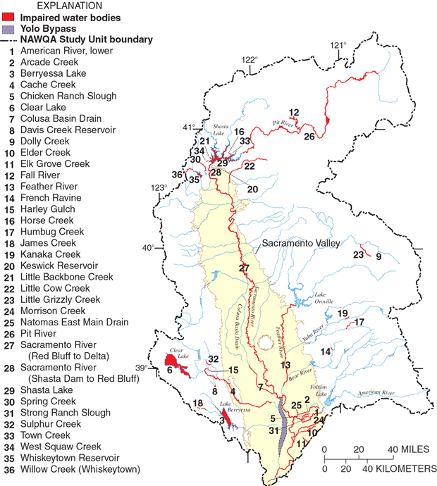 |
| Figure 8. Impaired water bodies of the Sacramento River Basin according to the California 303(d) list (U.S. Environmental Protection Agency, accessed January 2, 2000). Impaired water bodies require the implementation of a management plan called a Total Maximum Daily Load (TMDL) to bring the water body into compliance with existing standards. Most of the impairments are the result of pesticides from agricultural or urban use, or from metals derived from historical mining operations. |
|
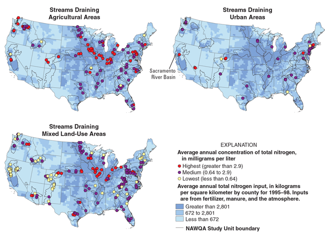
Nutrient concentrations in the streams of mixed land-use and agricultural regions of the Sacramento River Basin tend to be lower relative to those measured in other areas of the United States with similar fertilizer applications within their watersheds. The maps show nitrogen; phosphorus concentrations have a very similar pattern. Elevated concentrations of nitrogen or phosphorus can stimulate nuisance growth of algae. The nutrient concentrations tend to be less than those of adjacent areas in California, agricultural areas of the Pacific Northwest, and large areas of the midcontinent region. In contrast to mixed land-use streams, nutrient concentrations of the urban stream are among the highest of similar urban streams throughout the United States. The lower concentrations in streams of mixed land-use probably can be attributed to dilution by streamflow. The Sacramento River and its major tributaries are derived from melting snow, which has low nutrient concentrations. These rivers tend to dilute the agricultural drainage, and therefore nutrient concentrations remain low in the major rivers. In addition, some instream processes remove nutrients, such as algal growth that incorporates nutrients in algae biomass. The urban stream, Arcade Creek, is entirely within an urbanized area, and all runoff to the stream is affected by that urban land use. The only inputs of water to Arcade Creek are from impacted land. The range in nutrient concentrations for all NAWQA Study Units is shown in the Appendix.
|

The concentrations of molinate and other pesticides (used in rice farming) measured during this study in the Colusa Basin Drain or in the Sacramento River, represent a significant improvement over concentrations measured in previous years (Domagalski, 2000). The major pesticides that have been used on rice are molinate, thiobencarb, and carbofuran. Rice farming requires that fields be flooded with water throughout the growing season. Molinate and thiobencarb are applied to control aquatic grasses and weeds, whereas carbofuran is applied to control insects. During the late 1970s, the levels of rice pesticides in the Colusa Basin Drain were sometimes acutely toxic to fish such as carp (Cyprinus carpio) (Bennett and others, 1998). The toxicity was attributed to molinate.
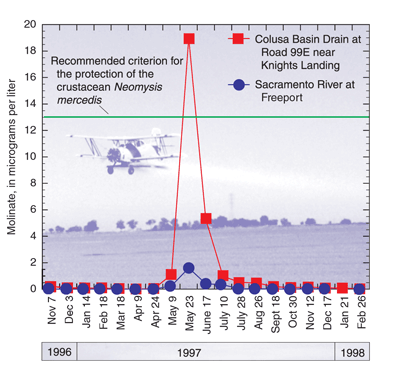 |
| Figure 9. Concentrations of molinate at the Colusa Basin Drain at Road 99E near Knights Landing and Sacramento River at Freeport sites. The water in the Colusa Basin Drain is primarily agricultural drainage. |
In the early 1980s, consumers of drinking water in the city of Sacramento reported an objectionable taste, which was attributed to thiobencarb. A management program was enacted to reduce the levels of these pesticides in streams. The plan requires that rice-field water be retained on fields for 1 month following pesticide application to allow concentrations in water to be reduced through mechanisms such as volatilization, biological processes, or sunlight-induced degradation. Sampling of rice pesticides during this study showed that concentrations occasionally were in excess of management objectives in agricultural streams but always were very low in the Sacramento River (fig. 9). A target concentration of 13 micrograms per liter (µg/L) of molinate in water was chosen for management of this herbicide. That level was chosen to protect the crustacean Neomysis mercedis, an important part of the food chain for young fish (Harrington, 1990). Concentrations in agricultural streams exceeded the target at least during 1 month of the year. Concentrations in the Sacramento River were always below those reported to be harmful to N. mercedis (Domagalski, 2000).
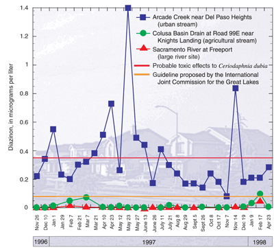 |
| Figure 10. Concentrations of diazinon at the Colusa Basin Drain at Road 99E near Knights Landing, Arcade Creek near Del Paso Heights, and Sacramento River at Freeport sites. The highest concentrations were in the urban stream, Arcade Creek. |
Pesticides also are transported to the Sacramento River, its tributaries, and agricultural drainage canals during winter storms (Kuivila and Foe, 1995; MacCoy and others, 1995; Domagalski, 1996). The pesticide that is considered a major problem for stormwater-driven transport is diazinon because of its toxicity to aquatic organisms and its high detection frequency. Diazinon is toxic to some species of zooplankton, such as Ceriodaphnia dubia, at low concentrations (0.35 µg/L) (Amato and others, 1992). The zooplankton species C. dubia, is used in laboratory assays to test water for toxicity (U.S. Environmental Protection Agency, 1991a,b). Diazinon is applied to orchard crops, especially almonds, prunes, and stone fruits, during December and January to protect trees from insects that lay eggs in the trees during the winter and hatch the following spring. Toxic concentrations in tributaries to the Sacramento River can occur when agricultural areas contribute storm runoff; toxic concentrations rarely occur in the Sacramento River itself (MacCoy and others, 1995). Diazinon was present in stormwater runoff at a number of sites in 1994 (Domagalski, 1996), and in nonstorm flows during 1996 through 1998. In the 1994 study, the Feather River was shown to be the greatest source of diazinon to the Sacramento River during a single storm, but other streams probably contributed to the diazinon load in the Sacramento River as well. This depended in part on the timing of diazinon applications and the location of greatest rainfall. The results of the routine samplings for diazinon during stable flow conditions at Arcade Creek near Del Paso Heights, Colusa Basin Drain at Road 99E near Knights Landing, and Sacramento River at Freeport are shown in figure 10. No stormwater runoff samples were collected. The highest concentrations during this NAWQA study occurred at Arcade Creek near Del Paso Heights, an urban site. Concentrations of diazinon in Arcade Creek that are toxic to C. dubia can occur in any season and result from household pesticide use and urban runoff. A standard for diazinon of 0.08 µg/L was proposed by the International Commission for the Great Lakes. As figure 10 shows, that standard was frequently exceeded at the Arcade Creek near Del Paso Heights site.
Organophosphate insecticides such as diazinon, chlorpyrifos, and malathion are toxic at low concentrations to some aquatic organisms. Some species of zooplankton are affected by diazinon concentrations as low as 0.35 µg/L. Diazinon levels at the urban stream, Arcade Creek, were elevated at various times of the year and exceeded recommended criteria for the protection of aquatic life for every measurement taken. Those levels were among the highest in the Nation. Most of the diazinon measured at the Arcade Creek site probably originated from household use throughout the watershed. Runoff from yards from either rainwater or irrigation water contributes to the loading of diazinon to stormwater drains that ultimately discharge into the creek. Diazinon enters agricultural drainage mainly in stormwater runoff because it is sprayed on orchards during the rainy winter season. Previous studies have shown that concentrations of diazinon in agricultural streams can be elevated less than a day after rainfall. Although diazinon concentrations of agricultural streams also were among the highest in the Nation, only one sample from those streams taken in this study exceeded recommended criteria. The range in diazinon concentrations for all NAWQA Study Units is shown in the Appendix. |

Pesticides that are no longer used, such as DDT, can still be detected in streambed sediments and the tissues of aquatic organisms because of their persistent chemical characteristics. Concentrations of pesticides such as DDT and its breakdown products tended to be low to nondetectable in the streambed sediments of the Sacramento River (MacCoy and Domagalski, 1999). Concentrations were higher in the streambed sediment of agricultural and urban streams. At some agricultural sites, and the urban site on Arcade Creek, the concentrations of DDT or its breakdown products in streambed sediment exceeded the Canadian sediment quality guidelines. The Canadian guidelines are designed to limit the accumulation of specific contaminants in organisms to levels below those that may adversely affect aquatic life (Canadian Council of Ministers of the Environment, 1995).
Concentrations of DDT or its breakdown products such as p,p'-DDE, or other organochlorine insecticide residues, were very low in the tissues of aquatic organisms collected in the Sacramento River and its large tributaries (fig. 11). Concentrations of p,p'-DDE in the tissues of aquatic organisms collected from agricultural drainage sites were higher (fig. 11). The levels found in tissues of aquatic organisms from the agricultural drainage sites probably do not pose a health risk for humans but are above criteria developed by the New York State Department of Environmental Conservation (Newell and others, 1987) for protection of fish-eating wildlife such as birds. No national criteria exist to protect fish-eating wildlife from organochlorine compounds such as DDT or its breakdown products; New Yorks are the only criteria available for comparison. The levels of p,p'-DDE found in the tissue of aquatic organisms tended to be relatively high when compared with other NAWQA Study Units. The range in concentrations for DDT and its breakdown products for all NAWQA Study Units is shown in the Appendix.
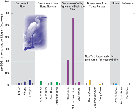 |
| Figure 11. Conentrations of p,p'-DDE (a DDT breakdown product) in biota from the Sacramento River Basin. The use of DDT in the United States was terminated in 1972. |
Metals in Water and Streambed Sediment
Acid mine drainage has been a serious environmental problem in the northern portion of the Sacramento River Basin (Alpers and others, 2000a,b). Several streams are listed as impaired (fig. 8) because of high concentrations of metals such as cadmium, copper, lead, and zinc. Metals concentrations in previous years have been toxic to fish in the upper Sacramento River near and downstream from Redding (Alpers and others, 2000a,b). Recent mitigation efforts at one of the more contaminated sites in the Spring Creek drainage near Shasta Lake have significantly lowered concentrations of metals in the Sacramento River, and no toxic effects to fish were observed during the course of this investigation (Alpers and others, 2000a,b). However, elevated levels of metals such as copper in streambed sediment can still be measured in the upper Sacramento River Basin downstream from Redding (MacCoy and Domagalski, 1999). Copper and other metals may still affect aquatic organisms.
| Trace Metals in Aquatic Organisms For the NAWQA Program, looking for trace metals includes sampling streambed sediment and tissues of aquatic organisms. In theory, the transfer of metals from the streambed sediment into aquatic organisms can be understood by knowing the concentrations and geochemical forms of the trace metals in both the sediment and biota, as long as the feeding behaviors of the organisms are also understood. A predictive model of metals in tissue that is based on the amounts in streambed sediment could be developed from these studies. In practice, this becomes difficult because the actual bioavailability of metals in sediment can vary from site to site. For example, the concentrations measured in aquatic organisms may not be fully assimilated into the cellular material of the organism but rather may be present as undigested material or even attached to external body parts. Because metals contamination from acid mine drainage is an important water-quality issue for the upper Sacramento River Basin, and knowledge of the actual bioavailability of metals in the mine drainage is essential for current and future management of the mine waste, a collaborative study was completed by the Sacramento River Basin NAWQA Program and the National Research Program of the USGS (Cain and others, 2000). In that study, biologists examined streambed sediment and the cytosol from the caddisfly, an aquatic insect widely distributed in the upper Sacramento River and part of the food chain for a variety of fishes, including salmonid species. Cytosol is cellular material that can be isolated from aquatic insects. Biologists analyzed both whole body samples and cytosol samples for metals. Metal concentrations in cytosol provide a good indication of the potential effects on aquatic organisms from acid mine drainage. Aquatic insects also were sampled in a nearby reference stream that was unaffected by acid mine drainage. Elevated levels of cadmium, copper, lead, and zinc, derived from acid mine drainage, could clearly be distinguished in the cytosol samples, and it was shown that metals from the acid mine drainage were transported at least 120 kilometers downstream from the mine sources. |
Mercury in Water and Streambed Sediment
Mercury is currently considered the most serious water-quality problem in the Sacramento River, some tributaries of the Sacramento River, and downstream locations including the San Francisco Bay (Domagalski, 1998). Mercury can enter streams or aquatic systems through either atmospheric deposition or transport from geological or man-made sources (fig. 12). Several processes contribute to the subsequent bioaccumulation of mercury in fish tissue. Because of the presence of mercury in the tissue of certain fish species, advisories have been posted for several water bodies, and more advisories are planned, both within the Sacramento River Basin and in the San Francisco Bay. Specific advisories for fish species and locations are listed on the California Office of Environmental Health Hazards Assessment Web site at http://www.oehha.org/fish.html. A recent study (Davis and others, 2000) documented mercury levels of concern to human health in sport fish collected in the lower Sacramento and Feather rivers.
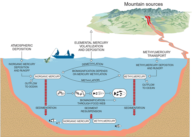 |
| Figure 12. Mercury pathways in aquatic systems. |
Although atmospheric mercury is the principal cause of mercury contamination of water bodies in other parts of the United States, especially the midwestern and eastern United States, the cause is different in California. Geologic and anthropogenic sources, especially from historical mining for both mercury and gold, are the main reasons for mercury problems in the Sacramento River Basin (Domagalski, 1998). Mercury was mined in the Coast Ranges near Clear Lake and at locations east and south of Clear Lake (fig. 3), and it was used in the recovery of gold from ore and stream deposits during the late 19th century (fig. 3).
Decades of gold mining in the Sierra Nevada have resulted in the deposition of mercury in the streambed sediments of the gold mining region. The release of mercury from ore to streambed sediments in the mercury mining regions of the Coast Ranges also has occurred (Hunerlach and others, 1999). The construction of reservoirs in the lower Sierra Nevada between 1948 and 1968 has had the positive effect of reducing the amount of mercury transported downstream (Slotton and others, 1997). Reservoirs trap mercury because suspended sediment, the principal means by which it is transported, tends to settle to the bottom. This trapping of mercury will have future implications on the management of these reservoirs, including potential dam removal. Some dams are being considered for removal in order to restore habitat for fish. Residual mercury from mining operations is present in the streambed sediments downstream from the Sierra Nevada reservoirs, as indicated by the NAWQA Program for the Sacramento River Basin. Concentrations of mercury in the streambed sediments of 24 sites sampled during the NAWQA Program are shown in figure 13. The highest concentrations of mercury in streambed sediment were measured in samples collected from sites downstream from the Sierra Nevada and the Coast Ranges. Sites on the Sacramento River downstream from the Feather River tended to have higher mercury concentrations relative to sites sampled upstream from the confluence of these two rivers because of historical gold mining.
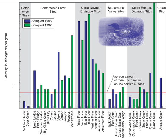 |
| Figure 13. Concentrations of mercury in streambed sediment at select locations of the Sacramento River Basin. |
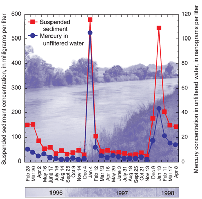 |
| Figure 14. Mercury and suspended sediment concentrations for the Sacramento River at Colusa site. Mercury concentrations increase with sediment concentrations because mercury is attached to sediment particles. |
The U.S. Environmental Protection Agency (EPA) has recommended water-quality criteria for mercury to protect aquatic life and human health. A recommended criterion of 12 nanograms per liter (ng/L) of total mercury in water was proposed by the EPA in 1985 (Marshack, 1995). That criterion is supposed to limit the amount of mercury accumulation in fish tissue and thereby protect human health. The 12-ng/L criterion was exceeded mainly during runoff conditions at all fixed sites during the timeframe of this investigation. In 1999, the recommended level was revised to 50 ng/L (U.S. Environmental Protection Agency, 1999). The 50-ng/L level was exceeded only at Cache Creek at Rumsey, Sacramento River at Colusa, and the Yolo Bypass at Interstate 80. Continued monitoring of mercury levels in fish tissue will be required to determine if the 50-ng/L criteria is effective. Time series plots of mercury and suspended sediment for the Sacramento River at Colusa are shown in figure 14. The higher concentrations of mercury correlate well with suspended sediment because much of the load of total mercury is transported with the suspended material (Alpers and others, 2000b).
Methylmercury is the most bioaccumulative form of mercury in the environment because it builds up in organisms more readily than other forms of mercury. It is a toxic form of mercury that can bioaccumulate in the tissues of aquatic organisms and cause human health problems if fish with high levels are consumed. Methylmercury usually is formed by bacterially mediated reactions in sediments. Concentrations in water were measured at selected sites on the Sacramento River and at sites receiving agricultural drainage to assess the effects of agricultural activities on the production or the levels of methylmercury.
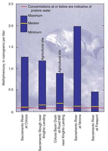 |
| Figure 15. Concentrations of methylmercury at select locations in the Sacramento River Basin. Methylmercury is the form of mercury most likely to accumulate in aquatic species such as fish. |
Concentrations of methylmercury in unfiltered water are shown in figure 15. The highest median concentration was 0.19 ng/L, which represents the samples collected at the Colusa Basin Drain at Road 99E near Knights Landing site. There is no water-quality standard in California or in any other State that is based on methylmercury concentrations in water. However, a concentration at or below 0.1 ng/L of methylmercury has been suggested as being representative of pristine water (Rudd, 1995). That concentration is typical of rivers upstream from wetland environments and away from mercury sources (Rudd, 1995). The median methylmercury concentrations for the Sacramento River sites were slightly above 0.1 ng/L and maximum concentrations approach 2 ng/L. It is not known how or if those levels of methylmercury in water contribute to elevated levels of mercury in fish tissue.
There was a seasonal component to methylmercury concentrations for the sites at which they were measured for this study. The lowest concentrations were measured during middle to late summer (fig. 16). Higher concentrations tended to be measured during the autumn to winter months. The magnitude of the concentrations may also have been related to precipitation and runoff conditions. The highest concentrations for the period of this study were measured during January and February of 1997 and were attributed to the January 1997 flood. During the subsequent El Niño winter of 199798, higher-than-normal amounts of rain were recorded for much of the Sacramento River Basin, although there was no single storm of the magnitude of the January 1997 flood. Methyl-mercury concentrations increased during the El Niño winter, but not to the extent of the flood of the previous year. The effect of these methylmercury concentrations on downstream water bodies, such as the San Francisco Bay, has not been determined.
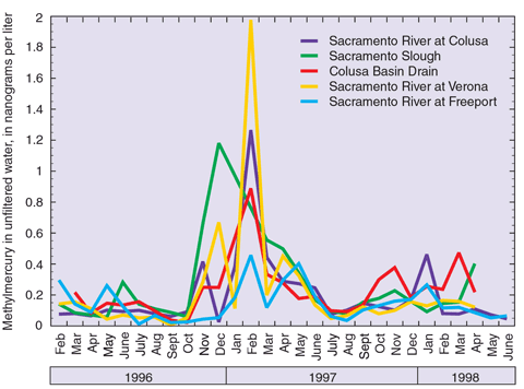 |
| Figure 16. Seasonal changes of methylmercury concentrations. The highest concentrations were measured during high streamflow and following rainfall. |
| Table of Contents || Previous Section || Next Section || Glossary U.S. Geological Survey Circular 1215 Suggested citation:
|
