
MAJOR FINDINGS
Bacteria Indicate the Presence of Fecal Contamination in Many Puget Lowland Streams
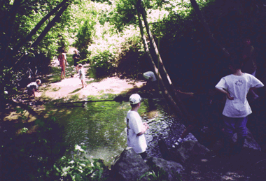 |
| Concentrations of bacteria in urban streams, which are attractive recreation areas, often exceed recommended concentrations for moderate water-contact recreation. (Photograph by Ward W. Staubitz, U.S. Geological Survey.) |
A study of 31 small lowland streams showed fecal coliform, E. coli, and enterococci bacteria to be present in every stream sampled during base flow. The presence of E. coli and enterococci bacteria is evidence that fecal contamination has occurred. During base flow, fecal contamination in urban streams could result from leaky sewer systems, failing septic systems, and direct fecal inputs from pets and wildlife, including waterfowl. In agricultural and rural streams, fecal contamination is likely to be mostly from animals, including farm animals (dairy and beef cattle, and horses). Other sources could be wildlife, with perhaps some input from onsite septic systems.
Concentrations of all three fecal-indicator bacteria frequently exceeded standards and criteria (fig. 16); 81 percent of all sites had concentrations of fecal coliforms exceeding Washington State standards, and 48 percent of all sites had levels of E. coli exceeding USEPAs recommended concentration for moderate water-contact recreation. Because concentrations of E. coli and enterococci are related to cases of gastrointestinal illness in swimmers (U.S. Environmental Protection Agency, 1986), there could be some risk of illness to children and adults playing and swimming in these accessible streams.
The types of fecal bacteria and their concentrations in streams were similar among urban, agricultural, and rural areas (fig. 16). However, concentrations of E. coli in the urban and agricultural streams were all well above those in the upper Green River in the forested headwaters of the basin.
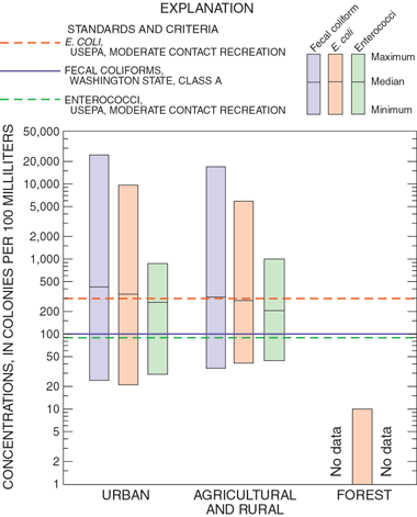 |
| Figure 16. Concentrations of E. coli and enterococci bacteria exceeded U.S. Environmental Protection Agency recreational criteria, and fecal coliform bacteria exceeded Washington State standards in many lowland streams. Concentrations of bacteria in single samples were compared with criteria and standards. USEPA criteria for moderate full-body contact recreation apply to a single sample (U.S. Environmental Protection Agency, 1986). Washington State standards for fecal coliform bacteria apply to the geometric mean of concentrations in samples collected during a period of no more than 30 days (State of Washington, 1992). Because no minimum number of samples is specified, the standard is routinely applied to concentrations in single samples (Hallock and others, 1996). |
Stream Habitat and Health Are Degraded in Agricultural and Urban Streams
During the late summer and early fall, between 1995 and 1998, the USGS and the Washington State Department of Ecology evaluated instream and riparian (streamside) habitat conditions at 45 sites. These evaluations indicated that habitat conditions at streams draining urban and agricultural basins were significantly different from those at streams draining basins with forest and undeveloped land (fig. 17). Compared with either urban or agricultural sites, forest and undeveloped stream sites had a much higher percentage of cobble substrate, ideal for a diverse population of aquatic organisms, and a lower percentage of sand, detrimental to salmon spawning. In addition, forest and undeveloped sites had a much higher variability in water flow velocities than either urban or agricultural sites. More variability in flow velocities increases habitat diversity and wildlife diversity. Midday water temperatures were also much lower in the forested streams. The higher temperatures observed in the agricultural and urban streams are not ideal for native salmon and other aquatic organisms.
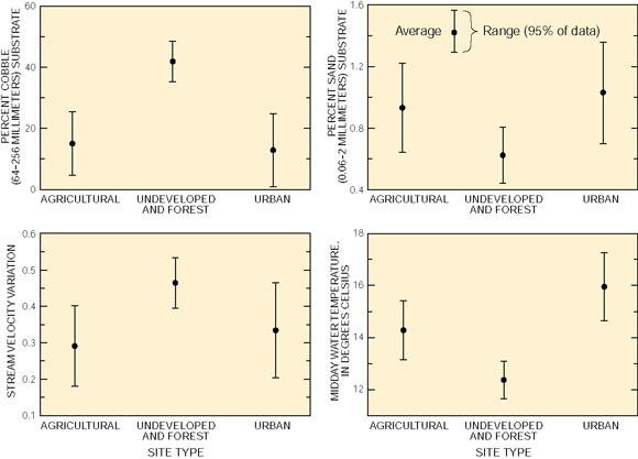 |
| Figure 17. Values of selected habitat variables indicate that habitat conditions are degraded in agricultural and urban streams compared with streams in forest and undeveloped land. For each habitat variable, except temperature, multiple measurements were taken within a 330- to 660-foot-long stream reach at each study site. |
Human Activities Have Altered Aquatic Invertebrate Communities
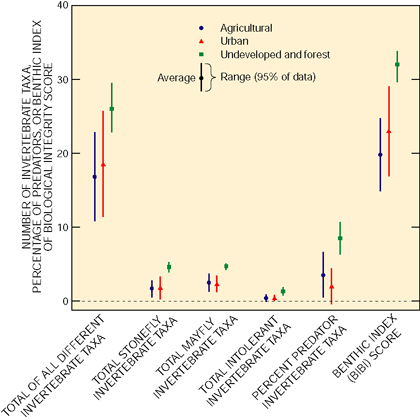 |
| Figure 18. As indicated by the average values of six different invertebrate community indicators of stream ecosystem conditions, conditions were better at sites in forest and undeveloped land than at sites in urban and agricultural areas. Lower values suggest a more degraded stream site. Taxa are different types of invertebrates. |
As part of the USGS and Washington State Department of Ecology habitat data collection, aquatic invertebrates (insects and worms) were also collected from multiple riffle habitats at all 45 sites. A number of invertebrate community measures were examined to evaluate the status and quality of the aquatic invertebrate community. For each invertebrate community measure, values were lower, significantly so in some cases, at the urban and agricultural sites (fig. 18).
Urban development and agriculture can reduce habitat quality, alter typical stream flows, and increase chemical contaminants and temperatures, all of which are reflected in invertebrate community measures. A reduction in the total number of different invertebrates, stoneflies, mayflies, intolerant invertebrates, and percentage of predatory invertebrates indicates stream eco-system degradation. For example, the total number of different invertebrates was much higher at the forest and undeveloped sites. A greater number of different invertebrates indicates a less degraded stream system capable of supporting more numerous desirable species such as salmon.
 |
|
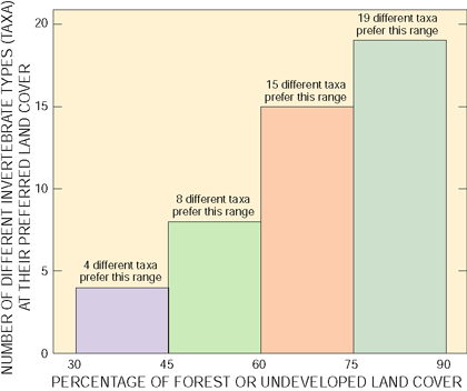
Figure 19. More different aquatic invertebrate types (taxa) prefer streams that have watersheds with greater than 75 percent forest/undeveloped land cover. Each bar represents the preferred range of forest/undeveloped land cover for the specified number of invertebrate taxa out of the 46 taxa identified in the Puget Sound Basin. An animal is healthiest when it is in its preferred range. This figure indicates that more different invertebrate taxa prefer sites in forested/undeveloped watersheds, but not that more invertebrate taxa or total numbers of invertebrates were found at these sites. The method used to determine preferred land-cover percentages was based on the work of Line and others (1994). |
A summation of many invertebrate community measures is also shown in figure 18. This measure is known as a Benthic Index of Biological Integrity (BIBI) and is an overall indication of the biological integrity or health of a particular stream site (Black and MacCoy, 2000). As seen in figure 18, urban and agricultural systems have lower biological integrity scores than the forest and undeveloped sites.
Streams in Urban and Agricultural Areas Have Less Than Optimal Amounts of Forest and Undeveloped Land to Support Healthy Aquatic Invertebrate Communities
A total of 46 different aquatic invertebrate taxa were identified at 45 sites throughout the Puget Sound Basin. Of the 46, only 4 taxa prefer watersheds with low forest/undeveloped land cover, whereas 19 taxa prefer watersheds with high forest/undeveloped land cover (fig. 19). These results indicate that streams in watersheds dominated by urban and agricultural land are optimally suited for only a few of the different taxa and many of these taxa are indicators of degraded stream ecosystems. Watersheds dominated by forest and undeveloped land are preferred by a much larger number of different invertebrate taxa, many of which are indicators of healthy stream systems.
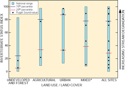
In the Puget Sound Basin, aquatic invertebrates collected at the 11 fixed monitoring sites were compared with those collected at 140 NAWQA sites nationwide. An Invertebrate status index (Tom Cuffney, U.S. Geological Survey, written commun., 2000) was developed by averaging 11 invertebrate metrics that summarized changes in richness, tolerance, food preference, and dominance associated with water-quality degradation. Invertebrate status scores in the basin ranged from low (less degraded) for streams in forest and undeveloped areas to high (more degraded) for other streams. As indicated by the invertebrate status scores, some Puget Sound Basin streams are highly degraded. This is the result of poor habitat conditions and possibly water chemistry. As shown in figure 17, high midday water temperatures and percent sand were observed in urban and agricultural streams, both of which have negative effects on aquatic organisms. In addition, numerous pesticides, some at concentrations above guidelines set to protect aquatic life, were detected at these sites (see Appendix). |

Ground-Water Quality is Generally Good
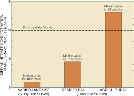 |
| Figure 20. Median nitrate concentrations in shallow ground water sampled for the study-unit survey (varied land use) were low. Higher nitrate concentrations were more common in both the residential land-use and agricultural land-use studies. |
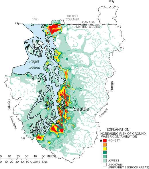
Prior to conducting field studies, an analysis of existing data was conducted to determine which Puget Sound Basin aquifers are most at risk to contamination. Unconfined aquifers that are overlain by coarse-grained glacial deposits (see map, p. 20) were found to be the most susceptible to contamination (see sidebar). Aquifers in coarse-grained glacial deposits in the Puget Sound Basin are collectively referred to as the Fraser aquifer. Three studies were conducted in the unconfined part of the Fraser aquifer (Inkpen and others, 2000). A study-unit survey was conducted by randomly selecting 30 domestic wells without regard to land use to evaluate the overall quality of shallow ground water. Ground-water-quality studies were also conducted in residential areas in Pierce and Thurston Counties and in an agricultural area in Whatcom County (see map, p. 20) to examine the influence of these important land-use categories on shallow ground water. Shallow ground water in all parts of the Fraser aquifer sampled is used for domestic supplies.
 |
|
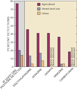
| Figure 21. A pesticide was detected in less than 15 percent of shallow ground-water samples beneath residential areas, and the most frequently detected compounds were each detected in less than 10 percent of these samples. |
The study-unit survey results indicate that ground water is of generally good quality, as only one well did not meet a drinking-water standard (for nitrate). Nitrate was detected in most wells, but the concentrations were low, having a median concentration of 1.0 mg/L (fig. 20). Pesticides were detected in 20 percent of study-unit survey wells (fig. 21) but were present at low concentrations (less than 0.2 µg/L) (micrograms per liter) and were well below drinking-water standards or guidelines. Based on data from a previous study (Ryker and Williamson, 1996), pesticides were not detected in wells more than 120 feet deep (Bortleson and Ebbert, 2000). Volatile organic compounds were detected frequently (80 percent of wells sampled) but were present at low concentrations (less than 1 µg/L).
Radon concentrations exceeded the proposed drinking-water standard of 300 picocuries per liter (U.S. Environmental Protection Agency, 1999a) in about 50 percent of the domestic and monitoring wells sampled for radon (table 3, p. 21). Radon is a naturally occurring product from the decay of uranium. The median concentration of radon in ground water in the Puget Sound Basin was 320 picocuries per liter. Elevated radon concentrations are by no means unique to the Puget Sound Basin. In fact, radon concentrations in ground water collected for NAWQA studies throughout the Nation exceeded the proposed standard more often and had a higher median value (420 picocuries per liter) than in the Puget Sound Basin (Wentz and others, 1999).
Nitrate Concentrations in Shallow Ground Water Beneath Residential Areas Were Elevated, but Concentrations of Other Compounds Were Low
Although nitrate concentrations in shallow ground water beneath the residential areas in Pierce and Thurston Counties were elevated compared with those in ground water sampled by the study-unit survey (fig. 20), only one sample exceeded the drinking-water standard. Stable isotope measurements of nitrogen in nitrate suggest that septic-system effluent is a significant source of nitrate in unsewered areas. Additional nitrate sources are indicated by the similar concentrations of nitrate in sewered and unsewered areas (Inkpen and others, 2000). Some nitrate in ground water in unsewered areas and most nitrate in sewered areas is likely from the application of fertilizers to lawns and gardens.
Pesticides Were Rarely Detected in Ground Water Beneath Residential Areas
In spite of the vulnerability of the unconfined Fraser aquifer, only a few pesticides were detected (fig. 21) and these were at low concentrations (less than 0.2 microgram per liter) beneath residential areas developed since 1970. These results suggest that pesticides currently used in residential areas may pose little risk to ground water. However, it should be noted that several commonly used pesticides (glyphosate, for example) were not analyzed.
Volatile Organic Compounds Were Detected Frequently at Low Concentrations in Ground Water Beneath Residential Areas
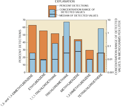
Although volatile organic compounds (VOCs) were detected in over 90 percent of shallow ground-water samples in residential areas, concentrations were low (fig. 22). Most detections were less than 0.05 µg/L, and none was above drinking-water standards or guidelines. Solvents, chlorinated by-products, and fuel-related compounds were the most commonly detected VOCs.
 |
| Figure 22. Volatile organic compounds were frequently detected at low concentrations in shallow ground water beneath residential areas. |
High Nitrate Concentrations and Fumigant-Related Compounds Were Detected in Shallow Ground Water Beneath an Agricultural Area
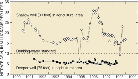
Nitrate concentrations in more than half of the shallow ground water sampled for the agricultural land-use study exceeded the drinking-water standard. Major sources of nitrate are animal manure from poultry and dairy operations and fertilizers applied to crops. High concentrations of nitrate have persisted for many years in wells sampled in this aquifer (Hii and others, 1999), suggesting that land applications of manure and inorganic fertilizers are contributing nitrate to this aquifer at a sufficient rate to sustain these levels (fig. 23).
 |
| Figure 23. Nitrate concentrations in shallow ground water often exceeded the drinking-water standard (10 milligrams per liter), with high concentrations persisting for many years. Nitrate concentrations in deeper ground water, while elevated, generally met the drinking-water standard. Both the shallow and deeper ground water are used for domestic supplies. |
Reactions in the Riparian Zone Remove Nitrate from Ground Water
Nitrate concentrations in ground water in the agricultural land-use study area commonly exceeded 10 mg/L, a concentration that can promote excessive plant growth in streams where this ground water discharges. A detailed analysis of water-quality changes along ground-water flow paths was conducted in this area (flow-path study area, p. 20). High nitrate concentrations persisted throughout much of the shallow aquifer. It was not until ground water reached the riparian zone of Fishtrap Creek that nitrate concentrations decreased to low levels (fig. 24). A decrease in nitrate concentrations in ground water concurrent with an increase in nitrogen gas (N2) concentrations in this zone is evidence that nitrate is being converted to N2 by denitrification (Tesoriero and others, 2000).
 |
| Figure 24. Nitrate concentrations in ground water remain high until water seeps through stream sediments that favor microbial denitrification. This process can effectively transform nitrate to nitrogen gas before the water discharges to the stream. |
High Concentrations of 1,2-Dichloropropane Were Probably Caused by Applications of Older Fumigant Formulations
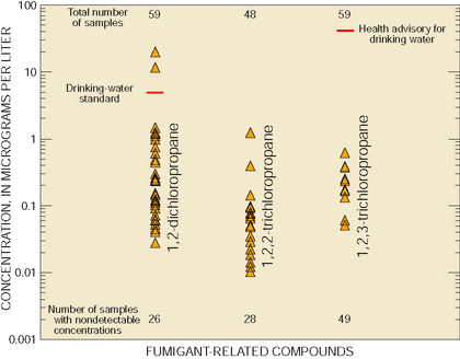
The most commonly detected volatile organic compounds in the agricultural land-use study area were associated with the application of fumigants to soils prior to planting. One or more fumigant-related compounds (1,2-dichloropropane, 1,2,2-trichloropropane, and 1,2,3-trichloropropane) were detected in over half of the samples. Each of these compounds is present in varying amounts in historically and/or presently used fumigants. Concentrations of 1,2-dichloropropane in water from two wells were above the drinking-water standard for this compound (fig. 25).
 |
| Figure 25. Fumigant-related compounds were detected frequently in shallow ground water in the agricultural land-use study area. Concentrations of 1,2-dichloropropane exceeded the drinking-water standard in two samples. |
The amount of 1,2-dichloropropane and 1,2,3-trichloropropane in fumigant formulations has dropped substantially over the past few decades (Zebarth and others, 1998), while the amount of 1,2,2-trichloropropane has decreased only slightly.
The relative amounts of these chloropropanes in ground water were compared with those present in fumigant formulations to determine the origin of these compounds in ground water (Tesoriero and others, in press). Results indicate that high concentrations of 1,2-dichloropropane in ground water are largely due to older formulations (fig. 26).
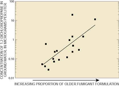 |
| Figure 26. Based on the relative amounts of chloro-propanes in samples, higher concentrations of 1,2-dichloropropane are likely derived from older fumigant formulations. |
|
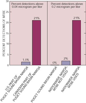
Areas that exceed air-quality standards for carbon monoxide are required to use a fuel oxygenate to comply with the Clean Air Act of 1990. Methyl tert-butyl ether (MTBE) is the most widely used oxygenate in the United States. However, frequent detections of MTBE, sometimes high concentrations, in ground water in areas where this compound is used has caused the USEPA to recommend that it be discontinued or reduced (U.S. Environmental Protection Agency, 1999b). MTBE is used in the Canadian part of the Puget Sound Basin but not in the U.S. part. Not surprisingly, detections of this compound were more frequent in the Canadian part of the Study Unit. When detected, MTBE concentrations were low (less than 0.2 microgram per liter). Low concentrations of MTBE are likely derived from nonpoint sources, such as stormwater runoff or atmospheric deposition, or from diluted point sources (Squillace and others, 1996).
|

| Table of Contents || Previous Section || Next Section || Glossary U.S. Geological Survey Circular 1216 Suggested citation:
|
