B
Water-Level Monitoring and Ground-Water Depletion in the High Plains Aquifer
Ongoing water-level monitoring in the High Plains aquifer documents the long-term ground-water depletion of a national resource and provides a good example of the type of water-level network required to assess ground-water availability in the Nation’s major aquifer systems. The High Plains aquifer is a 174,000-square-mile area underlying parts of eight States from South Dakota to Texas. Irrigation water pumped from the aquifer has made the High Plains one of the Nation’s most important agricultural areas.
The intense use of ground water has caused major water-level declines and reduced the saturated thickness of the aquifer (the ground water remaining in storage) in some areas to a level at which it is no longer economical to use the aquifer as a water supply. The changes are particularly evident in the central and southern High Plains (fig. B–1), where more than 50 percent of the predevelopment saturated thickness has been dewatered in some areas.
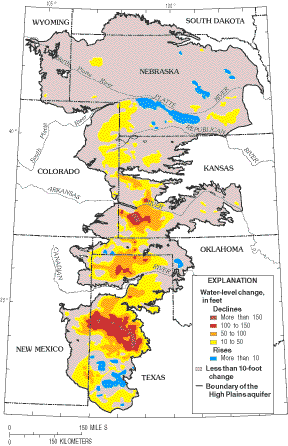 |
Figure B–1. Changes in ground-water levels in the High Plains aquifer from before ground-water development to 1997 (V.L. McGuire, U.S. Geological Survey, written commun., 1998). |
Water-level declines increase pumping lift, decrease well yields, and limit development of the ground-water resource. The net amount of water removed from storage in the aquifer is estimated to have been 220 million acre-feet (270 cubic kilometers) through 1999. This is a very large volume of freshwater—equal to more than half the volume of water in Lake Erie. If the total volume depleted from this single, multi-State aquifer was spread over the surface of the oceans, it would raise sea level about 0.75 millimeter, or about 0.5 percent of the sea-level rise observed during the entire 20th century.
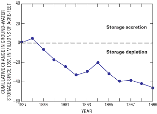
In response to declines in water levels and ground-water storage (fig. B–2), a monitoring program was begun across the High Plains in 1988 to assess annual ground-water-level changes in the aquifer. Water-level measurements have been made each year in more than 7,000 wells. This substantial effort requires collaboration among numerous Federal, State, and local water-resource agencies. Water levels continue to decline in many areas of the aquifer, but the monitoring program indicates overall reductions in the rate of decline during the past two decades in some areas (McGuire and Sharpe, 1997). This change is attributed to decreases in irrigated acreage, reduced water needs because of improved irrigation and cultivation practices, and above-normal precipitation and recharge during this period.
 |
|
Figure B–2. Cumulative changes in ground-water storage in the High Plains aquifer system since 1987. |
