D
Water Supply and Dry Rivers in the Humid East—Modeling the Effects of Water Withdrawals on Streamflow in the Ipswich River Basin, Massachusetts
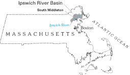
Water shortages, dry riverbeds, and impaired stream habitats are most often associated with the arid West. Yet with increasing regularity, these water-resource issues are making headlines in the humid East. Water withdrawals for domestic, commercial, and other uses in the Ipswich River Basin in northeastern Massachusetts (fig. D–1), for example, frequently cause streamflows in the upper one-third of the basin to become very low or to cease completely during the summer, which results in sections of dry riverbed. Reduced streamflows stress aquatic communities, cause fish and mussel kills during dry years, and limit the value of the river as a biological, recreational, and scenic resource.
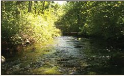
Recognizing that solutions to the basin’s water-resource problems require cooperation among the many stakeholders, the Ipswich River Task Force was formed in 1996 to address water-resource issues in the basin. The Task Force determined that a watershed model was needed to serve as a basis for water-resources-management decisions in the basin. The following year, the USGS, in cooperation with the Massachusetts Departments of Environmental Management and Environmental Protection, began development and testing of such a model to determine the effects of water-use and land-use patterns on streamflow in the basin (Zarriello and Ries, 2000). Results of the model indicate that ground-water withdrawals substantially decrease streamflows during periods of low flow. For example, the model estimated that because of ground-water withdrawals, the Ipswich River ceases to flow at the site shown in the photographs below during some low-flow periods; without such withdrawals, the river would maintain a minimum flow of about 2.5 million gallons per day.
The model is a dynamic tool that continues to be applied to water-related issues in the basin. Most recently, the model was used to determine streamflows at sites along the main stem of the Ipswich River that were identified in a related study to be critical for fish passage during low flows (Armstrong and others, 2001). Model simulations were required because natural (unregulated) flow conditions are unknown at these sites. Results of the modeling and stream-habitat studies are currently being used by the Massachusetts Department of Environmental Protection to help establish withdrawal limits for water-supply wells, and are the cornerstone of a comprehensive watershed management plan being developed for the basin.
 |
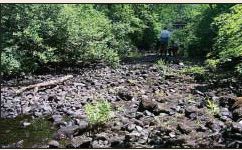 |
| Figure D–1. View of the Ipswich River near South Middleton, Massachusetts, during normal streamflow (left) and during the summer drought of 1999 (right). Figures modified from Zarriello and Ries, 2000. Photographs by David Armstrong and Timothy Driskell. | |
