 Introduction
Circum-Pacific Map Project
The Circum-Pacific Map Project was a cooperative international effort designed to show the relationship of known energy and mineral resources to the major geologic features of the Pacific basin and surrounding continental areas. Available geologic, mineral, and energy-resource data are being complemented by new, project-developed data sets such as magnetic lineations, seafloor mineral deposits, and seafloor sediment. Earth scientists representing some 180 organizations from more than 40 Pacific-region countries are involved in this work.
Six overlapping equal-area regional maps at a scale of 1:10,000,000 form the cartographic base for the project: the four Circum-Pacific Quadrants (Northwest, Southwest, Southeast, and Northeast), and the Antarctic and Arctic Sheets. There is also a Pacific Basin Sheet at a scale of 1:17,000,000. The Base Map Series and the Geographic Series (published from 1977 to 1990), the Plate-Tectonic Series (published in 1981 and 1982), the Geodynamic Series (published in 1984 and 1985), and the Geologic Series (published from 1984 to 1989) all include six map sheets. Other thematic map series in preparation include Mineral-Resources, Energy-Resources and Tectonic Maps. Altogether, more than 50 map sheets are planned. The maps were prepared cooperatively by the Circum-Pacific Council for Energy and Mineral Resources and the U.S. Geological Survey and are available from the Branch of Distribution, U. S. Geological Survey, Box 25286, Federal Center, Denver, Colorado 80225, U.S.A.
The Circum-Pacific Map Project is organized under six panels of geoscientists representing national earth-science organizations, universities, and natural-resource companies. The six panels correspond to the basic map areas. Current panel chairmen are Tomoyuki Moritani (Northwest Quadrant), R. Wally Johnson (Southwest Quadrant), Ian W.D. Dalziel (Antarctic Region), vacant. (Southeast Quadrant), Kenneth J. Drummond (Northeast Quadrant), and George W. Moore (Arctic Region).
Project coordination and final cartography was being carried out through the cooperation of the Office of the Chief Geologist of the U.S. Geological Survey, under the direction of General Chairman, George Gryc of Menlo Park, California. Project headquarters were located at 345 Middlefield Road, MS 952, Menlo Park, California 94025, U.S.A.
The framework for the Circum-Pacific Map Project was developed in 1973 by a specially convened group of 12 North American geoscientists meeting in California. The project was officially launched at the First Circum-Pacific Conference on Energy and Mineral Resources, which met in Honolulu, Hawaii, in August 1974. Sponsors of the conference were the AAPG, Pacific Science Association (PSA), and the Coordinating Committee for Offshore Prospecting for Mineral Resources in Offshore Asian Areas (CCOP).
The Circum-Pacific Map Project operates as an activity of the Circum-Pacific Council for Energy and Mineral Resources, a nonprofit organization that promotes cooperation among Circum-Pacific countries in the study of energy and mineral resources of the Pacific basin. Founded by Michel T. Halbouty in 1972, the Council also sponsors conferences, topical symposia, workshops and the Earth Science Series books.
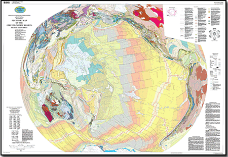
Tectonic Map Series
The tectonic maps distinguish areas of oceanic and continental crust. Symbols in red mark active plate boundaries, and colored patterns show tectonic units (volcanic or magmatic arcs, arc-trench gaps, and interarc basins) associated with active plate margins. Well-documented inactive plate boundaries are shown by symbols in black. The tectonic development of oceanic crust is shown by episodes of seafloor spreading. These correlate with the rift and drift sequences at passive continental margins and episodes of tectonic activity at active plate margins. The recognized episodes of seafloor spreading seem to reflect major changes in plate kinematics. Oceanic plateaus and other prominences of greater than normal oceanic crustal thickness such as hotspot traces are also shown. Colored areas on the continents show the ages of deformation and metamorphism of basement rocks and the emplacement of igneous rocks. Transitional tectonic (molassic) and reactivation basins are shown by a colored boundary, and if they are deformed, a colored horizontal line pattern indicates the age of deformation. Colored bands along basin boundaries indicate age of inception, and isopachs indicate thickness of platform strata on continental crust and cover on oceanic crust. Colored patterns at separated continental margins show the age of inception of rift and drift (breakup) sequences. Symbols mark folds and faults, and special symbols show volcanoes and other structural features.
Affiliations are as of compilation of the data. This map was created in quadrants and then compiled together. They are the Northwest land, Northwest Marine (different compilers), Northeast, Southwest and Southeast, and parts in plate-boundary sections.
~~~~~~~~~~~~~~~~~~~~
Chief Compiler and Tectonic Interpretations
E. Scheibner
Contributing Authors Based on Quadrant Compilations
Arctic: G.W. Moore. NE Quadrant: K.J. Drummond.
Antarctic: I.W. Dalziel. SE Quadrant: Q.J. Corvalan.
NW Quadrant: T. Moritani and Y. Teraoka.
SW Quadrant: E. Scheibner, T. Sato, and C. Craddock.
Compilation Coordinated by Warren O. Addicott and George Gryc
Cartography and compilation by Fran R. Mills and Douglas S. Aitken

