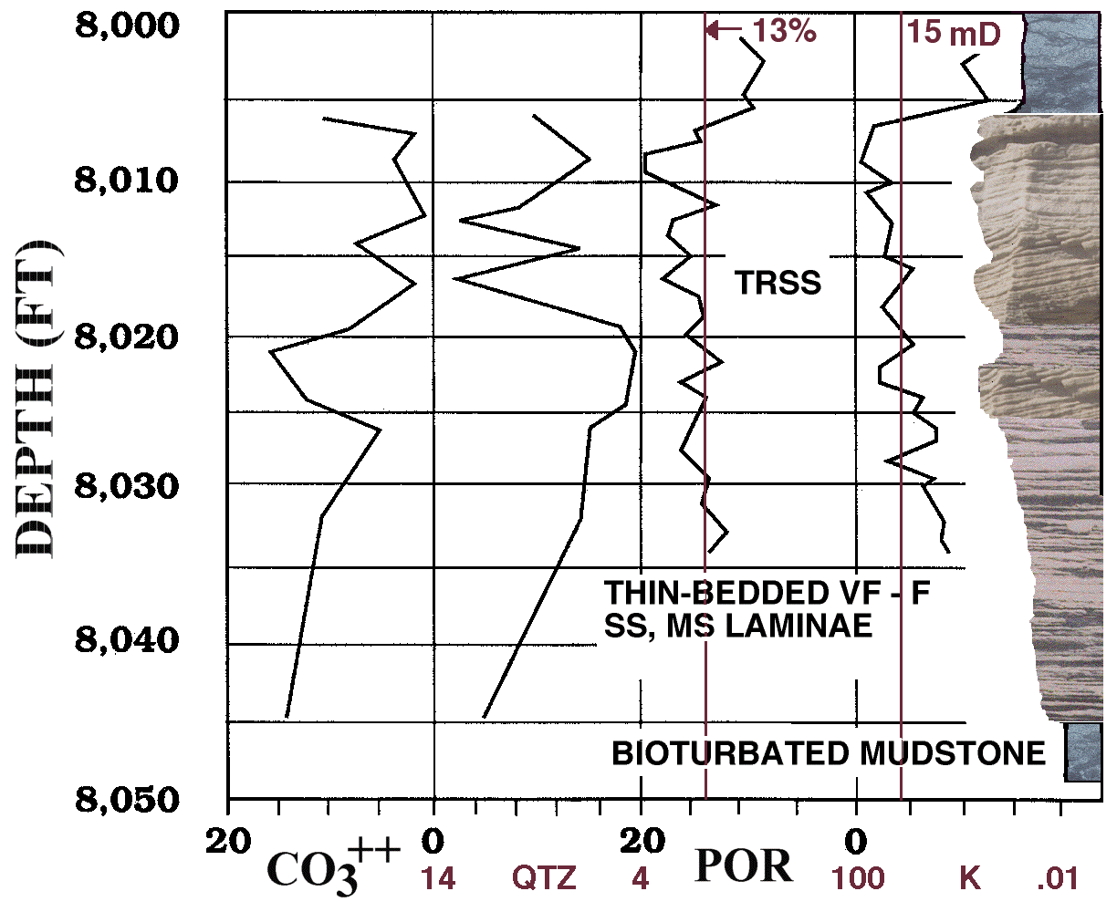
Figure 28. Shown are 1) 20 to 0 percent calcite (CO3++) and 14 to 4 percent quartz (QTZ) cements, 2) 20 to 0 percent core porosity (POR), 3) 100 to 0.01 mD permeability (K), and 4) photographs showing facies for the Sussex "B" sandstone, Empire Federal "C" oil well. TRSS is trough-cross-bedded sandstone intervals; these are concentrated near the top of the "B" sandstone and are the primary reservoir facies. "THIN-BEDDED VF-F SS, MS LAMINAE" refers to the thin-bedded horizontally stratified fine-grained sandstone and interbedded mudstone. Bioturbated mudstone is the blue-gray-colored rock located mainly at the base and top of this section. Heavy vertical bar on the right side of the figure is the perforated zone. The full-scale 144 KB image is empfedsr.gif.
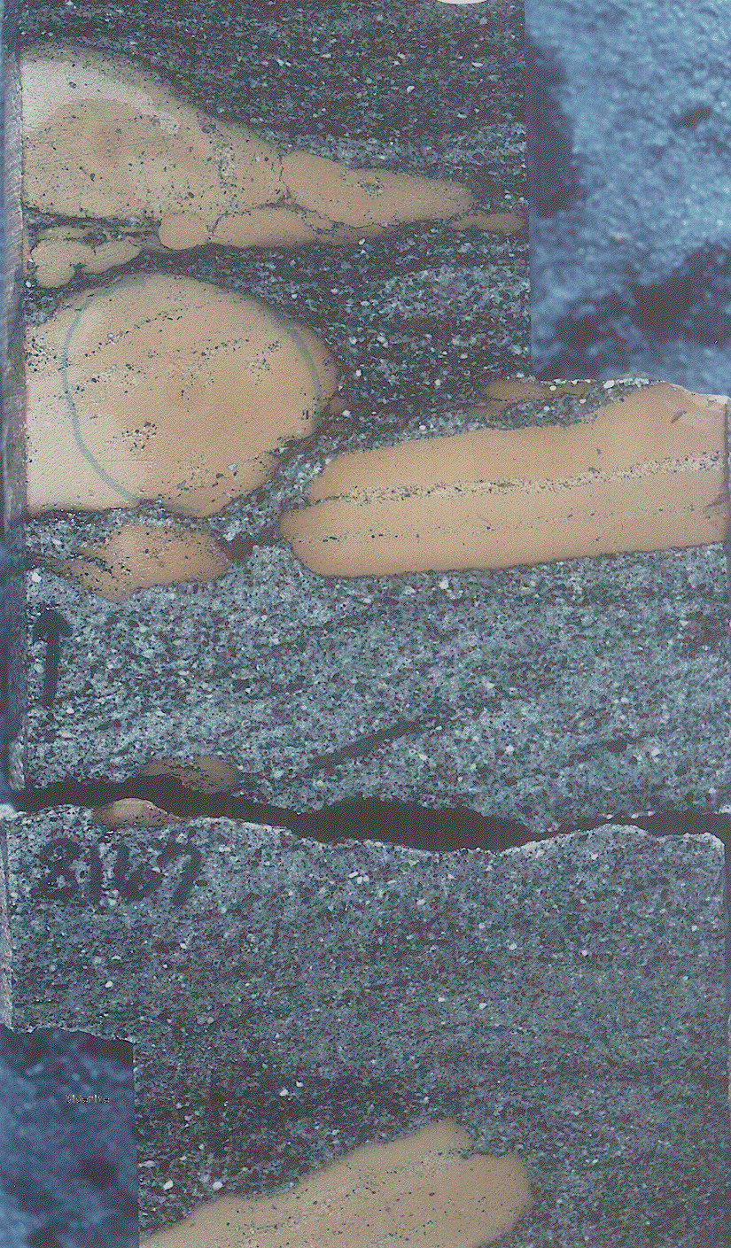
Figure 29. Core photograph (trs8167s.gif) from 8,167-ft depth in the Mandel Federal "C" well shows siderite clasts that were ripped up by high-energy currents and redeposited on the trough-cross-bedded sands of submarine dunes. Original horizontal bedding is shown in clasts by the stringers of quartz grains. The full-scale trs8167.gif image is 992 KB.

Figure 30. Thin-section photomicrograph of a siderite clast in a chert-pebble lag, No. 14-1 Federal well, Porcupine field (foramsm.gif). Foraminifera tests in the clast that have been partially replaced by siderite (brown). Evidence for the marine origin of the siderite clasts includes alteration to siderite of Haplophragmoides and Reophax foraminiferal tests. The full-size foram.gif image is 768 KB.
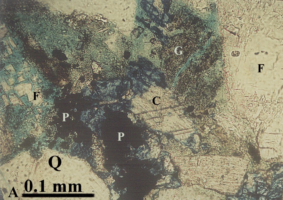
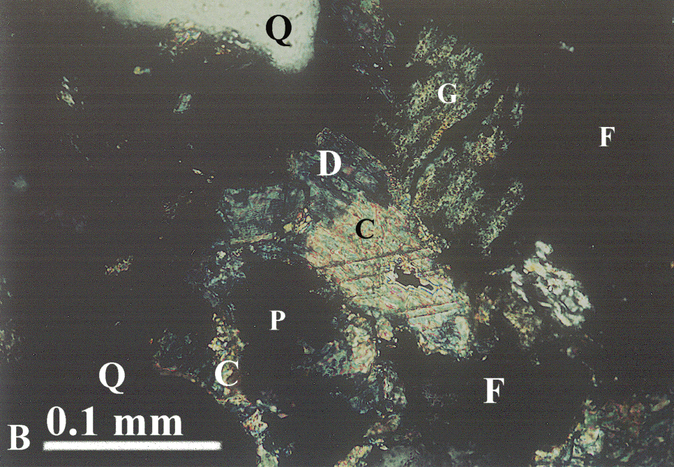
Figure 31. A. Transmitted-light and B. crossed-nicols thin-section photomicrographs of pyrite framboids (P) within ferroan dolomite (D) from a trough-cross-bedded sandstone at 8,014-ft (2,443 m) depth in the Empire Federal "C" oil well. Quartz (Q) and feldspar (F) grains bound optically-continuous calcite (C) cement. G is a glauconite pellet. Medium blue is epoxy and mottled blue results from kaolinite clay (transmitted light view), dark blue on both views is the late-diagenetic ferroan dolomite. Full-size transmitted-light image is 752 KB pyrca1.gif. Full-size crossed-nicols view is 784 KB pyrca2.gif.
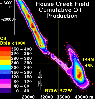
Figure 32. Contour map of cumulative oil production across the House Creek field area. Field is delineated by the red line. Contour interval is 40,000 barrels of oil. Map scale, in meters, is shown around the margin. Township and range line intersections are also drawn. Greatest production is proximal to field axes; these are also areas of stacked sand ridges; oil is commonly produced from 2 sandstone bodies separated by a permeability barrier. Porosity and permeability generally decrease west of the eastern margins of the field, so increase in production along the field axes is a function of thickest intervals of stacked sandstones with greatest porosity and permeability.
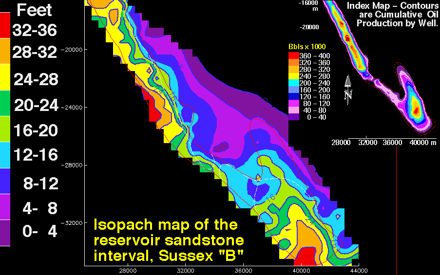
Figure 33. Sussex "B" sandstone isopach showing thickness in feet of the reservoir-grade sandstone interval. The House Creek field is delineated by red lines; the faint white lines outline sand ridge boundaries. Contour interval is 4 ft (1.2 m). Map scales are meters. In some areas, contours are extrapolated outside of data control. Reservoir sandstone intervals were determined by examining well-log traces of about 120 wells, as well as core and petroleum production data; boundaries correspond to a cut-off of about 8.5 percent porosity. This interval includes lower porosity sandstone and mudstone located within and between sand ridges. Index map is cumulative oil production across the field; contour interval is 40,000 barrels of oil (BO) for the range 0 to 400,000 BO. Resiso.gif is the large-scale 64 KB contour map of reservoir intervals.
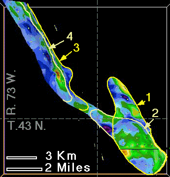
Figure 34. Plan-view map on the upper disconformity surface of the Sussex "B" sandstone within the House Creek field. Reservoir-grade intervals are shown by green through red (8 to 21 percent porosity); low-porosity non-reservoir intervals are purple through blue (1 to 8 percent porosity). Sand ridges 1 through 4 and field boundaries are delineated by yellow and tan; dashed lines separate townships and ranges. Basal sand ridges are 1 and 3.
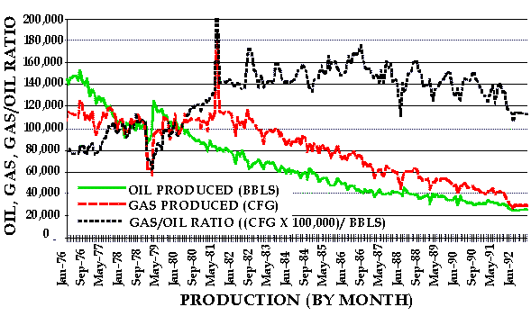
Figure 35. Production decline curve for monthly intervals from 1976 through August 1992 in the House Creek field. Oil (BBL), gas (CFG) and gas/oil ratio (GOR) curves are shown. GOR is multiplied by 100,000 to better view increase in through time of gas production relative to oil. Water production is not shown due to small volumes. Cumulative production to January 1976 was 8.73 MMB of oil and 4.06 MMCF of gas (Petroleum Information Corp. production data).
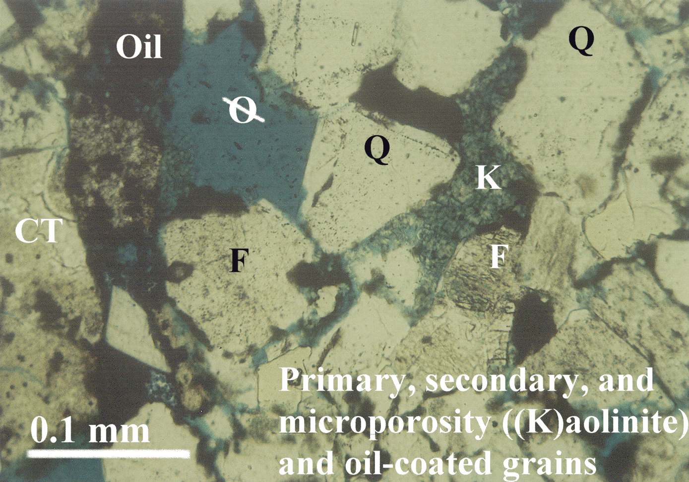
Figure 36. Transmitted-light thin-section photomicrograph of an oil-productive trough-cross-bedded, medium-grained sandstone from the House Creek field. Oil (brown) coats primary and secondary pore spaces. Spotty distribution of oil in the kaolinite (K) results from low permeability and microporosity. Feldspar (F) grain is partially dissolved. Quartz (Q) and chert (CT) grains are labeled. Blue epoxy fills pore spaces (ellipse with a line through it). The full-size photomicrograph is oilstn.gif, 1.4 MB .