Chapter 1 Executive Summary
|

|
Chapter 1 of
Petroleum Systems and Geologic Assessment
of Oil and Gas in the
Uinta-Piceance Province, Utah and Colorado
By USGS Uinta-Piceance
Assessment Team
U.S. Geological Survey Digital Data Series DDS-69-B
Version 1.0
2003
U.S. Department of the Interior
Gale A. Norton, Secretary
U.S. Geological Survey
Charles G. Groat, Director
For sale by U.S. Geological Survey,
Information Services Box 25286, Denver Federal Center Denver, CO 80225
Any use of trade, product, or
firm names in this publication is for descriptive purposes only and does
not imply endorsement by the U.S. Government
Published in the Central Region, Denver, Colorado
Manuscript approved for publication July 24, 2002
ISBN=0-607-99359-6
Contents
Introduction
Resources Assessed
Resource Summary
Uinta-Piceance
Province Assessment Team
Reference Cited
Figures
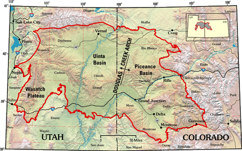
1.
Map showing location of Uinta-Piceance Province in northeastern Utah and northwestern
Colorado
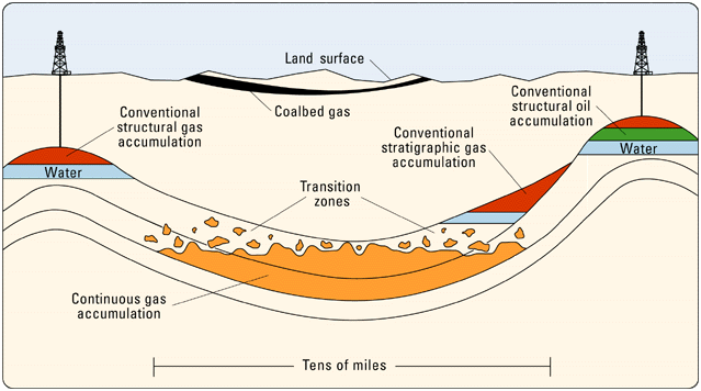
2.
Schematic diagram of the types of oil and gas resources assessed in provinces
of the United States
Table
1.
Uinta-Piceance Province assessment results.
(This page is best
viewed in Internet Explorer or Microsoft Excel)
Table 1. Uinta-Piceance Province assessment
results.
[MMBO, million barrels of oil; BCFG, billion cubic
feet of gas; MMBNGL, million barrels of natural gas liquids. Results
Results shown are fully risked estimates. For gas
fields, all liquids are included under the NGL (natural gas liquids) category
Undiscovered
gas resources are the sum of non-associated and associated gas. F95
represents a 95 percent chance of
at least the amount tabulated. Other fractiles are
defined similarly. Fractiles are additive under the assumption of perfect
positive correlation. Gray shade indicates not
applicable. CBG is coalbed gas.]
Total Petroleum Systems
(TPS)
and Assessment Units (AU)Field Type
Total Undiscovered Resources
Oil (MMBO)
Gas (BCFG)
NGL (MMBNGL)
F95
F50
F5
Mean
F95
F50
F5
Mean
F95
F50
F5
Mean
Phosphoria TPS
Hanging Wall AU
Oil
1.75
4.13
8.37
4.47
0.47
1.21
2.67
1.34
0.03
0.07
0.17
0.08
![]()
Gas
10.48
24.78
50.27
26.81
0.30
0.78
1.70
0.86
Paleozoic/Mesozoic AU
Oil
2.66
5.82
11.55
6.29
0.71
1.70
3.69
1.89
0.04
0.10
0.23
0.11
Gas
15.82
43.74
94.30
48.04
0.47
1.36
3.21
1.54
Ferron/Wasatch Plateau TPS
Ferron Sandstone Gas AU
Gas
10.73
35.91
81.23
39.75
0.03
0.07
0.19
0.08
Mesaverde TPS
Mesaverde Sandstone Gas AU
Gas
17.91
58.95
140.12
66.41
0.13
0.46
1.18
0.53
Green River TPS
Uinta Green River Oil and Gas AU
Oil
2.74
9.14
20.52
9.63
7.59
24.83
63.73
28.88
0.42
1.45
3.98
1.73
Total Conventional
Resources
7.15
19.09
40.44
20.39
63.71
191.12
436..01
213.12
1.42
4.29
10.66
4.93
Mancos/Mowry TPS
Piceance Basin AU
Gas
649.30
1,463.09
3,296.86
1,652.90
0.60
1.43
3.45
1.65
Uinta Basin AU
Gas
1,781.69
2,965.07
4,934.43
3,110.69
3.16
5.81
10.67
6.22
Uinta-Piceance Transitional
and Migrated Gas AUGas
1,429.61
1,742.59
2,124.11
1,755.26
0.74
1.98
5.31
2.37
Ferron/Wasatch Plateau TPS
Deep (>6000 feet)
Coal and Sandstone AUGas
0.00
52.04
136.43
59.10
0.00
0.00
0.00
0.00
![]()
Northern Coal Fairway/
Drunkards Wash AUCBG
451.14
722.18
1,156.05
752.33
0.00
0.00
0.00
0.00
Central Coal Fairway/
Buzzards Bench AUCBG
311.61
512.69
843.54
536.73
0.00
0.00
0.00
0.00
Southern Coal Fairway AU
CBG
78.16
145.81
255.49
152.59
0.00
0.00
0.00
0.00
Southern Coal Outcrop AU
CBG
0.00
9.95
30.71
10.56
0.00
0.00
0.00
0.00
Mesaverde TPS
Uinta Basin Continuous AU
Gas
4,134.18
7,018.47
11,915.02
7,391.36
5.52
10.31
19.27
11.09
Uinta Basin Transitional AU
Gas
889.42
1,431.73
2,304.72
1,492.97
1.18
2.10
3.76
2.24
Piceance Basin Continuous AU
Gas
1,902.23
2,956.15
4,594.01
3,064.27
5.00
8.69
15.09
9.19
Piceance Basin Transitional AU
Gas
161.74
284.47
500.33
301.73
0.29
0.56
1.07
0.60
Uinta Basin Blackhawk
Coalbed Gas AUCBG
181.97
433.84
1,034.28
498.78
0.00
0.00
0.00
0.00
Mesaverde Group
Coalbed Gas AUCBG
138.72
322.45
749.54
367.77
0.00
0.00
0.00
0.00
Green River TPS
Deep Uinta Overpressured
Continuous Oil AUOil
24.83
37.57
56.84
38.78
35.72
60.74
103.29
63.99
2.23
4.17
7.79
4.48
Total Continuous
Resources
24.83
37.57
56.84
38.78
12,145.49
20,121.27
33,978.81
21,211.03
18.72
35.05
66.41
37.84
Total Undiscovered
Oil and Gas Resources
31.99
56.66
97.28
59.17
12,209.20
20,312.39
34,414.82
21,424.15
20.14
39.34
77.07
42.77
AccessibilityFOIAPrivacyPolicies and Notices
![]()

US Geological Survey Digital Data Series
DDS-69B