
Figures 1-9, Wrangell Volcanic Field
Figures 10-32, Mount Spurr Volcano
Figures 33-67, Redoubt Volcano
Figures 68-70, Iliamna Volcano
Figures 71-97, Augustine Volcano
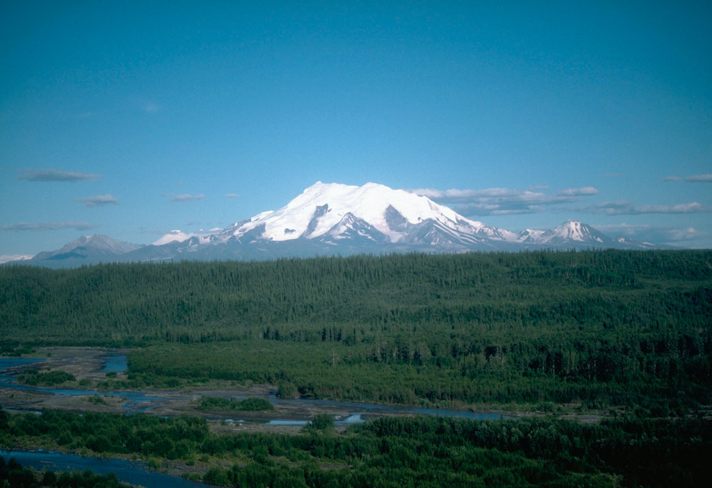
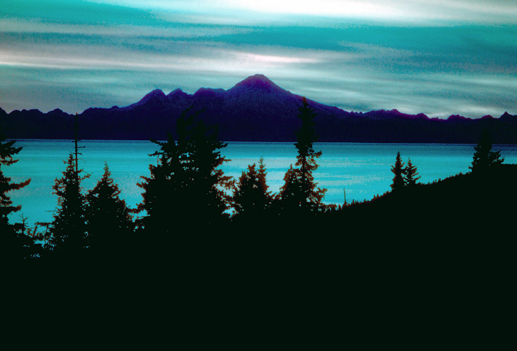
2. Mount Wrangell, a 4,317-m (14,163 ft)-high andesite shield volcano is visible to the left on the skyline; it is the only volcano in the Wrangell Mountains to have had documented historical activity. This consisted of several minor, possibly phreatic eruptions in the early 1900's. Mount Drum, 3,661 m (12,011 ft) high, is the westernmost volcano in the Wrangell volcanic field, and is visible to the right on the skyline. The Copper River is in the foreground. View is to the southeast. Photograph by D. Richter, U.S. Geological Survey, August 1981.
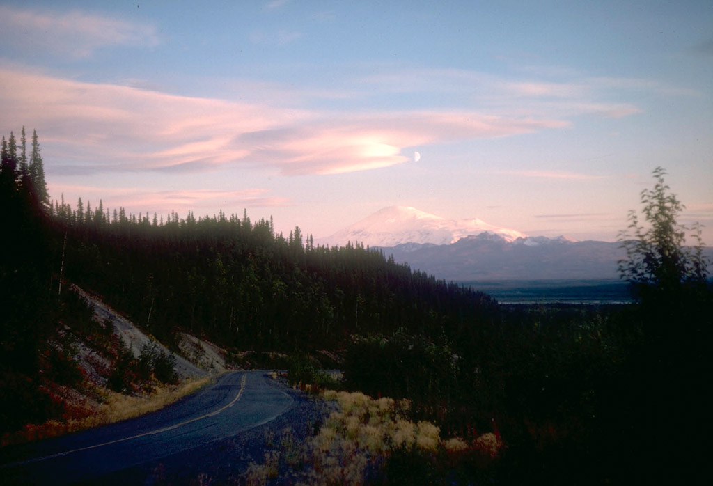
3. Half moon over Mount Sanford, a dissected andesite shield volcano. At 4,949 m (16,237 ft), it is the highest volcano in the Wrangell volcanic field. Capital Mountain, a 2,356-m (7,731 ft)-high andesite shield volcano, is in the middle foreground. View is to the south. Photograph by D. Richter, U.S. Geological Survey, 1963.
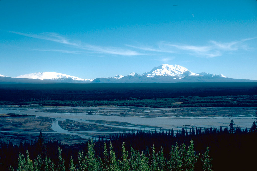
4. View, looking southeast, of 4,949-m (16,237 ft)-high Mount Sanford (left) and 4,317-m (14,163 ft)-high Mount Wrangell (right) on the skyline. Photograph by D. Richter, U.S. Geological Survey, August 1981.

5. Mount Wrangell, a 4,317-m (14,163 ft)-high andesite shield volcano on the right skyline, is the only volcano in the Wrangell Mountains to have had documented historical activity consisting of several minor, possibly phreatic eruptions in the early 1900's. At left is Mount Zanetti, a 3,965-m (13,009 ft)-high cone. View is to the northeast. Photograph by B. Cella, U.S. National Park Service , 1987.
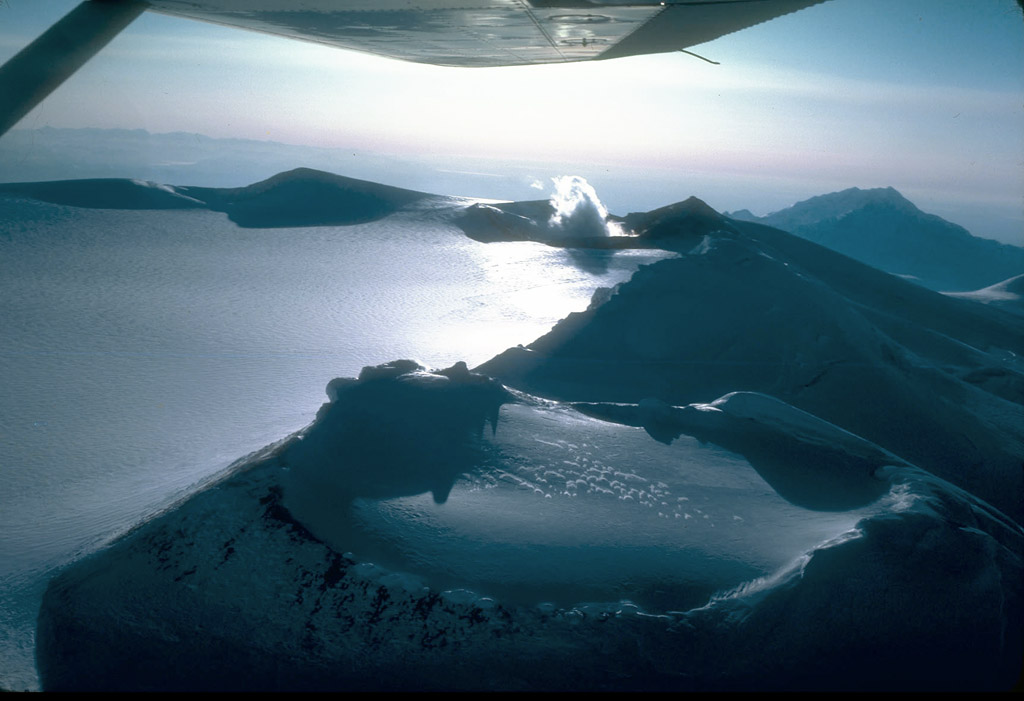
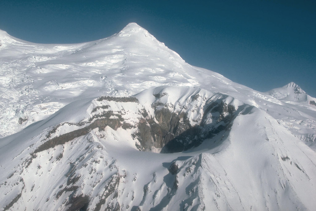
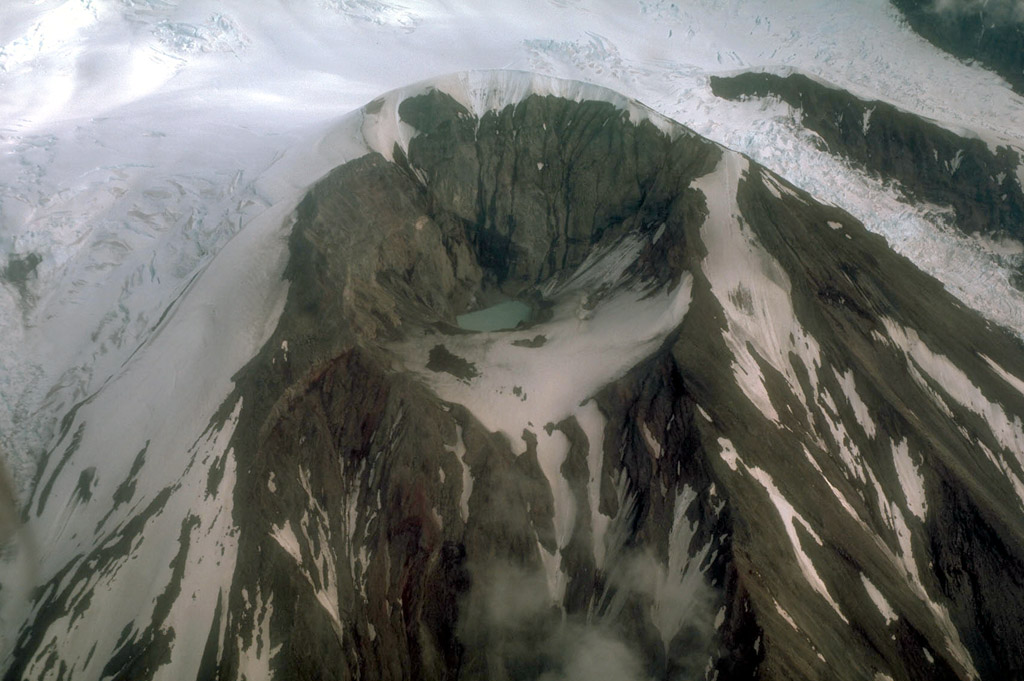
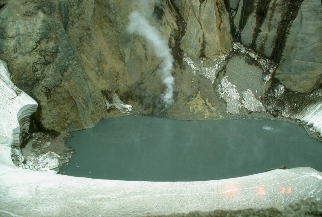
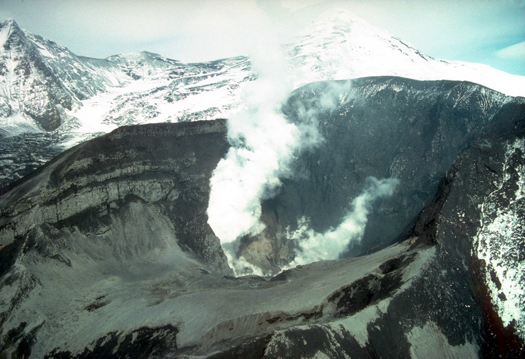
6. Aerial view looking southwest of a portion of the 4-6 km ice-filled summit caldera of Mount Wrangell, a 4,317-m (14,163 ft)-high andesite shield volcano. It is the only volcano in the Wrangell volcanic field to have had documented historical activity consisting of several minor, possibly phreatic eruptions in the early 1900's. Active fumaroles exist at one of three cinder cones on the caldera rim. Photograph by R. Motyka, Alaska Division of Geological and Geophysical Surveys, 1981.

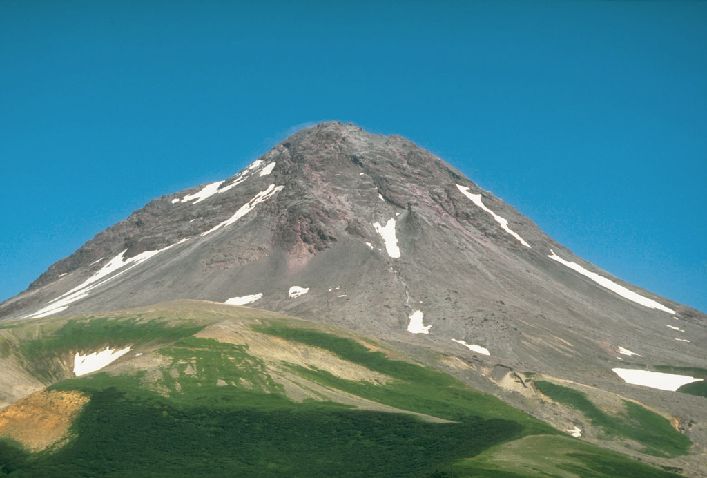
7. Mount Jarvis, 4,091 m (13,421 ft) high, is the youngest volcano in the eastern Wrangell volcanic field. Mount Jarvis was active approximately 1 to 2 million years ago. View is to the southeast. Photograph by R. McGimsey, U.S. Geological Survey, July 15, 1991.
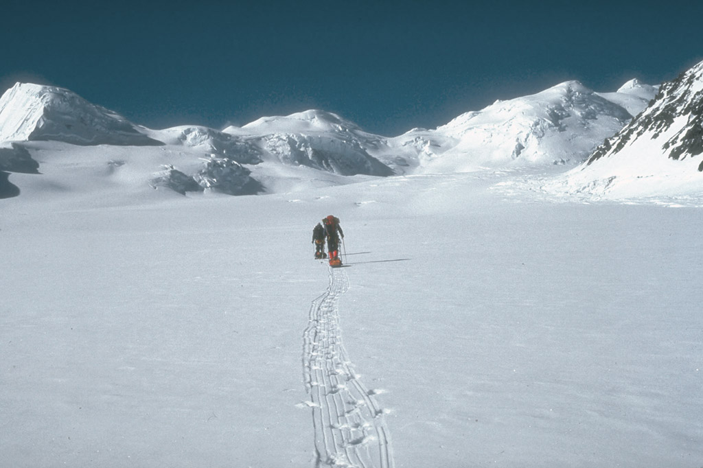
8. U.S. Geological Survey climbing party ascending the Klutlan Glacier en route to 4,766- m (15,636 ft)-high Mount Churchill. This volcano was the site of two of the most voluminous explosive eruptions in North America in the past 2,000 years. View is to the southwest. Photo by R. McGimsey, U.S. Geological Survey, May 16, 1990.
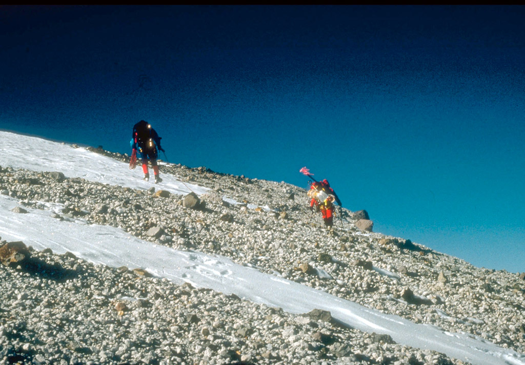
9. U.S. Geological Survey climbing party reaching the east rim of the summit caldera on 4,766-m (15,636 ft)-high Mount Churchill, site of two of the most voluminous explosive eruptions in North America in the past 2,000 years. Blocky debris in the photo consists of pumice and lithic fragments ejected 1,250 years ago. This deposit forms the eastern lobe of the White River Ash. Photo by G. Dubois, U.S. Geological Survey, May 20, 1990.

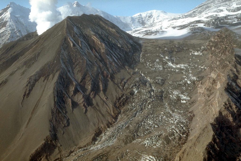
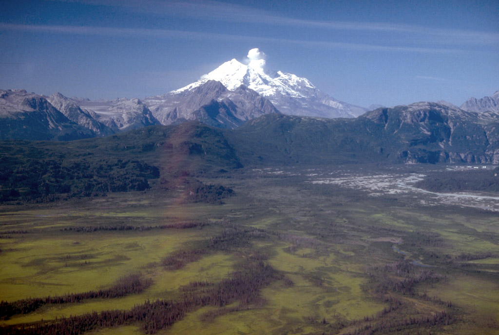
11. Crater Peak, a satellite vent, is located in a breach in the south wall of the ice-filled caldera of Mount Spurr volcano. It was the site of historical eruptions from Mount Spurr volcano in 1953 and 1992. Mount Spurr is the snow- and ice-covered peak on the skyline. View is to the north. Photograph by C. Neal, U.S. Geological Survey, June 3, 1993.
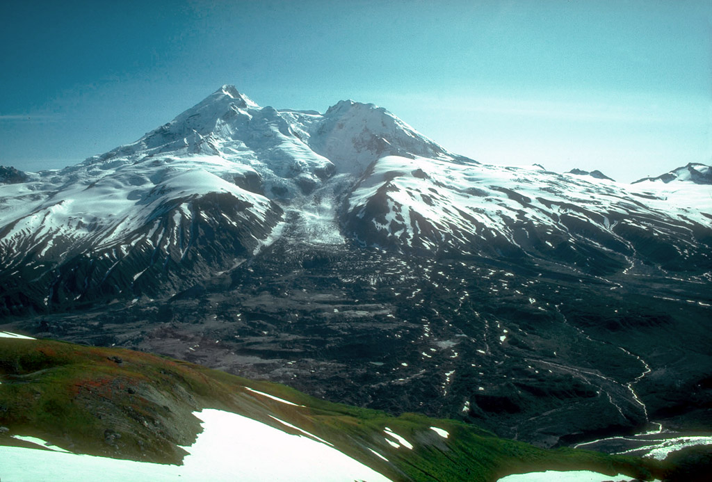
12. Crater Peak, a satellite vent of Mount Spurr volcano, and the snow- and ice-covered summit lava dome complex of Mount Spurr beyond. View is to the north. Photograph by R. McGimsey, U.S. Geological Survey, 10/9/91.
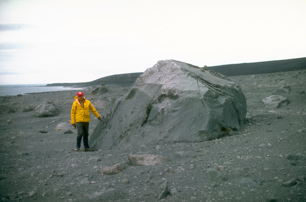
13. As shown here, prior to its 1992 eruptions, Crater Peak, a satellite vent of Mount Spurr volcano, contained a warm lake about 100 m (330 ft) across. Photograph by D. Turner, University of Alaska Fairbanks, 1986.
14. In early June, 1992, this lake inside Crater Peak vent at Mount Spurr volcano had a temperature of 49.7�C (121�F) and a pH of 2.5. Note a circular upwelling zone about 5 m (16 ft) across at the middle right, and the vigorously steaming talus pile on the far shore. Photograph by R. McGimsey, U.S. Geological Survey, June 11, 1992.

15. Alaska Volcano Observatory scientist (upper right) observing hydrothermal activity inside the Crater Peak vent of Mount Spurr volcano stands on a rampart of pyroclastic debris deposited during the 1953 eruption. Photograph by R. McGimsey, U.S. Geological Survey, June 11, 1992.
16. Following a brief, violent eruption on June 27, 1992, the interior of the Crater Peak vent steams vigorously. Newly deposited pyroclastic debris covers the interior of the crater and the preeruption crater lake shown in photograph 14 is completely gone. View is to the north. Photograph by C. Nye, Alaska Division of Geological and Geophysical Surveys, June 28, 1992.
17. Vertical eruption column and spreading eruption cloud from the Crater Peak vent, Mount Spurr volcano (top to right). View is to the north. Photograph by S. Walker, August 18, 1992.
18. Vertical eruption column and spreading eruption cloud from the Crater Peak vent, Mount Spurr volcano. A lighttan cloud ascending from pyroclastic flows is visible at right. The summit lava dome complex of Mount Spurr volcano, 3,374-m (11,070 ft)- high, is visible at lower left. View is to the north. Photograph by R. McGimsey, August 18, 1992.
19. Close aerial view, looking east, of the base of the vertical eruption column from the Crater Peak vent, Mount Spurr volcano. Photograph by R. McGimsey, U.S. Geological Survey, August 18, 1992.
20. Aerial view, looking north, of the eruption column from the Crater Peak vent, Mount Spurr volcano. A light-tan cloud ascending from pyroclastic flows is visible at right. The 3,374-m (11,070 ft)-high summit lava dome complex of Mount Spurr is visible at left. Photograph by R. McGimsey, U.S. Geological Survey, August 18, 1992.
21. Avalanches of pyroclastic debris ejected during the August 18, 1992, eruption of the Crater Peak vent, Mount Spurr volcano, formed overlapping, lobate tongues of material that blanketed the lower southeastern slopes of Crater Peak. Bombs ejected from Crater Peak during the eruption produced impact craters which dot the surface; some craters reached up to 5 m (16 ft) in diameter. Photograph by C. Neal, U.S. Geological Survey, September 3, 1992.
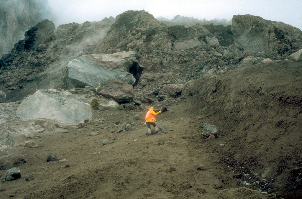
22. Alaska Volcano Observatory scientist sampling the pyroclastic flow deposit from the August 18, 1992, eruption of Crater Peak, a satellite vent of Mount Spurr volcano. View is to the northwest looking up the southeast flank of Crater Peak. Photograph by R. McGimsey, U.S. Geological Survey, September 9, 1992.
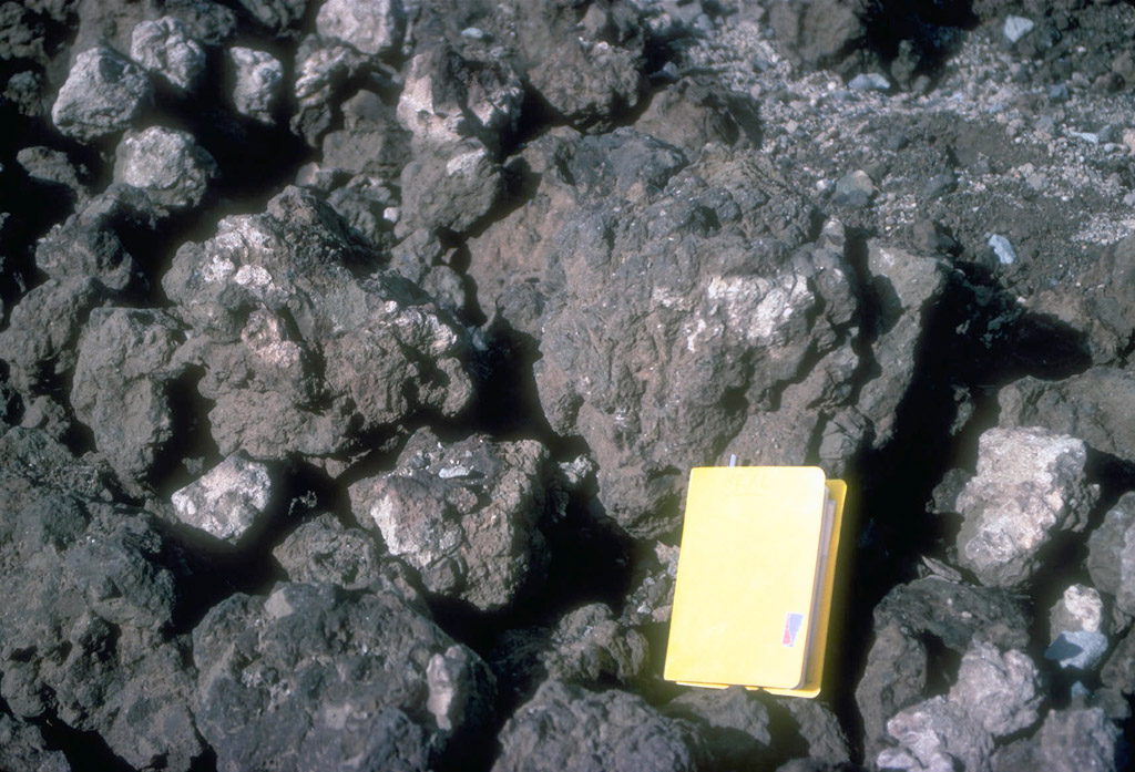
23. Juvenile material ejected during the August 18, 1992, eruption of Crater Peak, a satellite vent of Mount Spurr volcano. Ejecta that fell near the volcano consisted principally of these poorly inflated, brown "cauliflower "-textured andesite bombs. Field notebook (14x20 cm; [6x8 in]) shows scale. Photograph by C. Neal, U.S. Geological Survey, September 3, 1992.

24. Impact crater formed by a dense lithic block ejected during the August 18, 1992, eruption of the Crater Peak vent of Mount Spurr volcano. View is to the southeast. Photograph by C. Neal, U.S. Geological Survey, September 9, 1992.
25. Tephra from the 1992 eruptions of the Crater Peak vent, Mount Spurr volcano, blanketed narrow swaths of the surrounding countryside. In this view, about 15 cm (6 in) of coarse sand to gravel-sized tephra is exposed in the pit. The surface is dotted with cobblesized bombs from the September 16 to 17, 1992, eruption. Photograph by R. McGimsey, U.S. Geological Survey, September 23, 1992.
26. Within several kilometers of the Crater Peak vent, Mount Spurr volcano, tephra-fall from the 1992 eruptions stripped bark from woody vegetation (bush is about 1.5 m [5 ft] across). Photograph by C. Neal, U.S. Geological Survey, September 9, 1992.
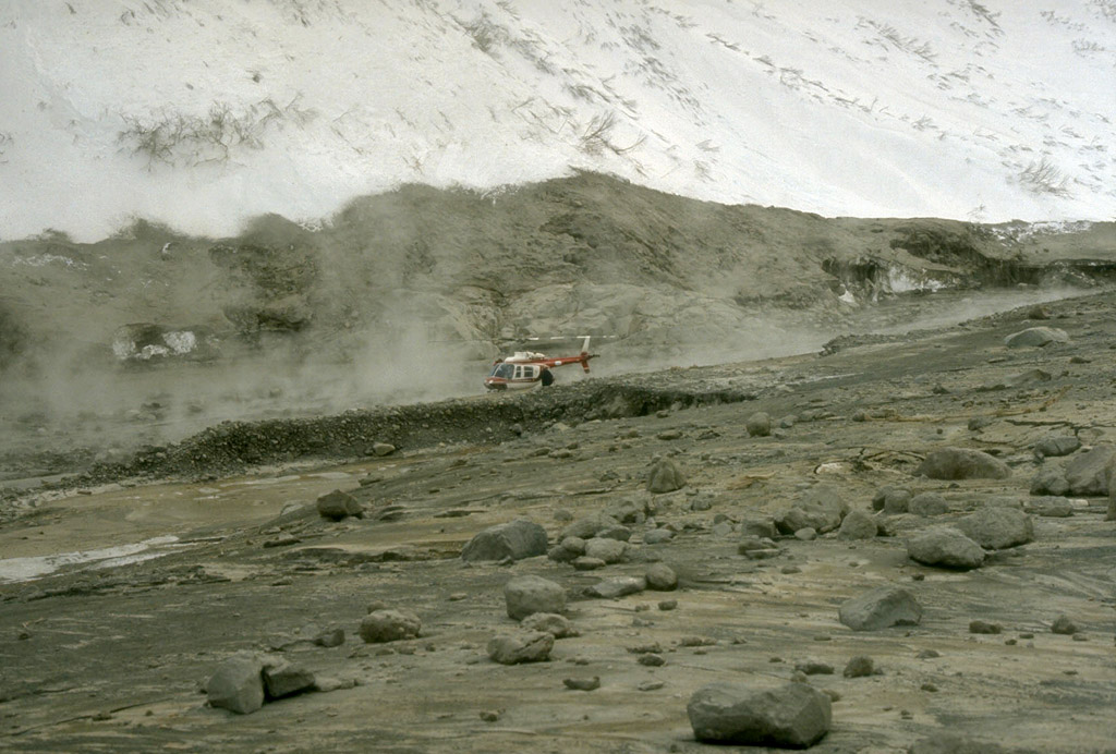
27. The final 1992 eruption of the Crater Peak vent, Mount Spurr volcano, showered hot debris onto the Kidazgeni Glacier immediately east of Crater Peak. In this view, steam billows from Crater Peak. Dark pyroclastic material blankets the flanks of Crater Peak and the adjacent glacial ice. Photograph by C. Gardner, U.S. Geological Survey, September 23, 1992.
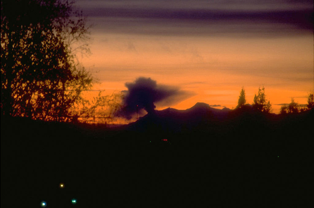
28. Hot pyroclastic debris from the September 16 to 17, 1992, eruption of the Crater Peak vent, Mount Spurr volcano, melted deep channels into the crevassed Kidazgeni Glacier. The debris combined with meltwater to produce mudflows or lahars that reached the Chakachatna River, 7 km (4 mi) distant. Photograph by C. Neal, U.S. Geological Survey, September 24, 1992.
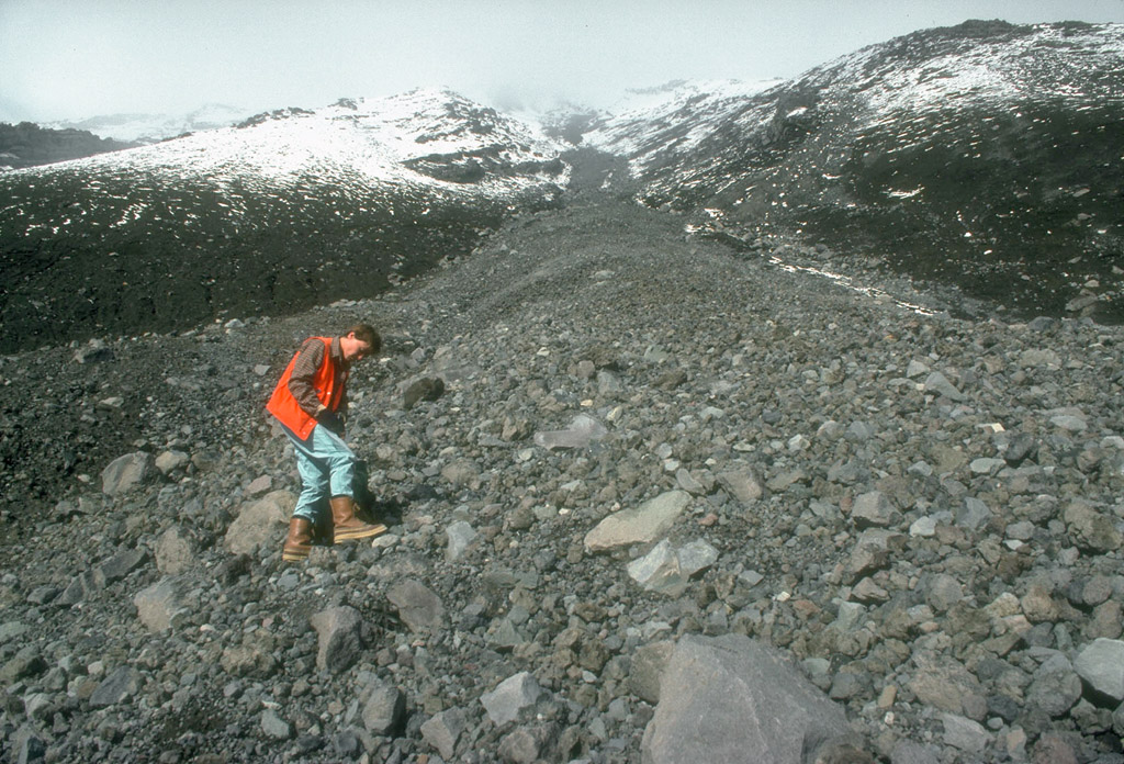
29. Alaska Volcano Observatory scientist examining lahar deposits formed during the September 16 to 17, 1992, eruption of the Crater Peak vent, Mount Spurr volcano. Photograph by R. McGimsey, U.S. Geological Survey, September 17, 1992.
30. In this sunset view (westward) from the rooftop of the Alaska Volcano Observatory in Anchorage, a prominent steam and gas plume rises from the Crater Peak vent, Mount Spurr volcano. Photograph by M. Doukas, U.S. Geological Survey, October, 1992.

31. Aerial view of Crater Peak vent, Mount Spurr volcano. Following the three eruptions of 1992, the interior of Crater Peak was partially filled with pyroclastic debris to a thickness of more than 20 m (65 ft). A plume of steam and volcanic gas, at times vigorous, continued to emanate from the vent for several years. Photograph by C. Gardner, U.S. Geological Survey, September 26, 1992.

32. Seismometers such as this one installed near Mount Spurr volcano (on skyline in background) provide the Alaska Volcano Observatory with a continuous, radio-telemetered record of volcanic earthquakes. These data are used to monitor the state of activity at the volcano and are critical to the ability of the Observatory to issue timely warnings of eruptions. View is to the north. Photograph by C. Neal , U.S. Geological Survey, June 3, 1993.

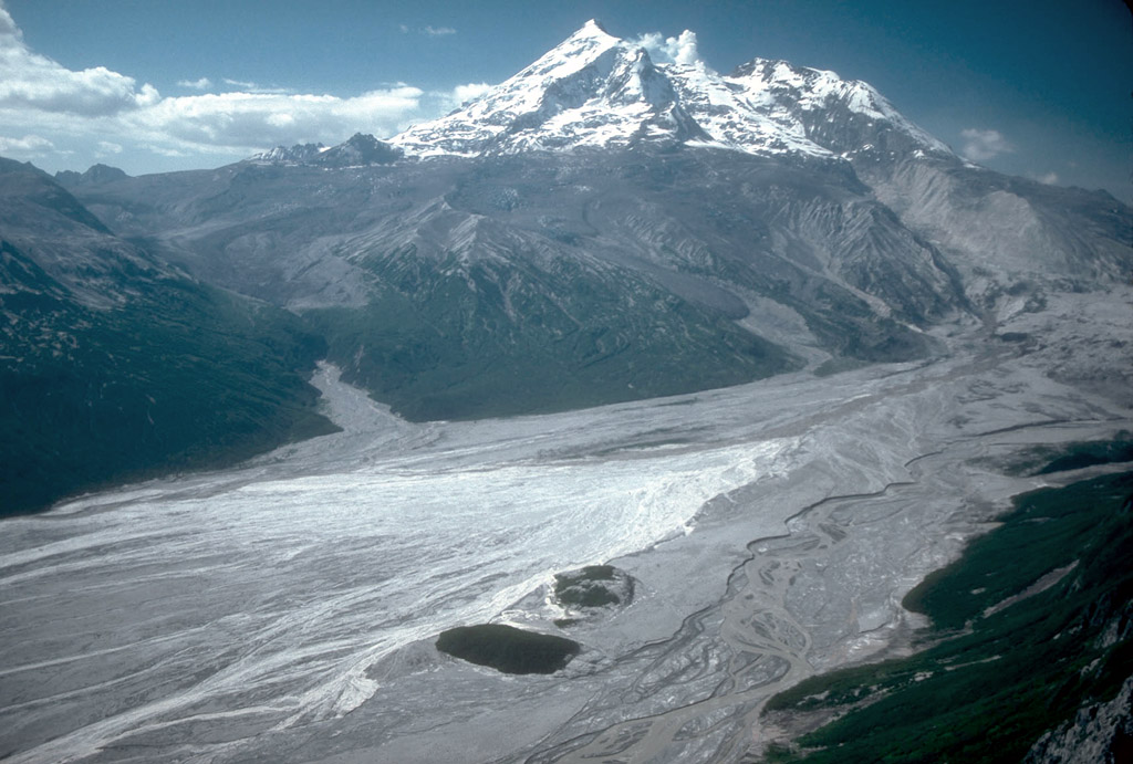
34. Redoubt Volcano, 3,108 m (10, 197 ft) high, is one of the active volcanoes of the Cook Inlet region. Steam and volcanic gas rise above the summit of the volcano following the 1989 to 1990 eruptions. View is to the west. Photograph by C. Gardner, U.S. Geological Survey, July 6, 1990.
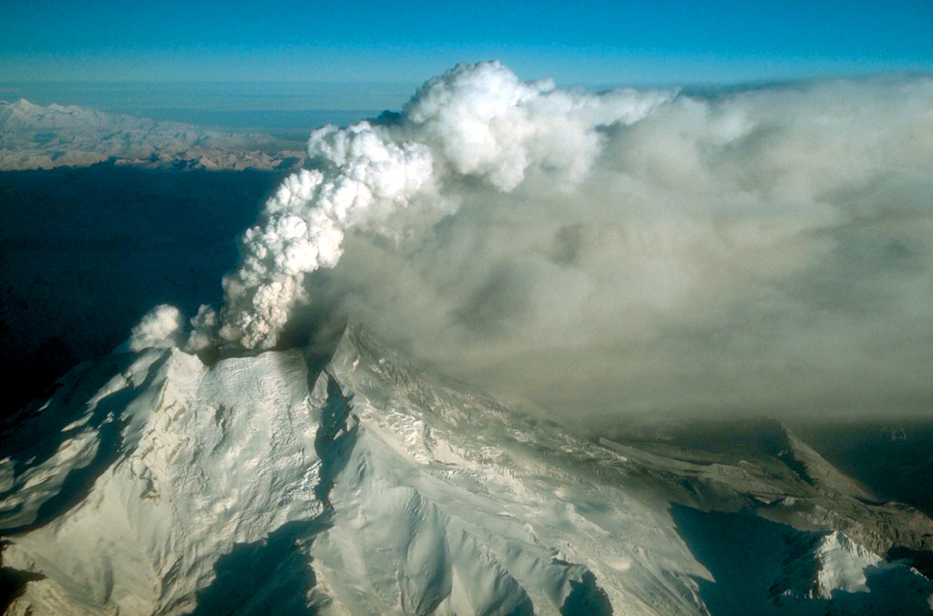
35. Redoubt Volcano, 3,108 m (10, 197 ft) high, is one of the active volcanoes of the Cook Inlet region. The breached summit crater is drained by Drift glacier, which empties into the Drift River valley forming a piedmont lobe. View to the south. Photograph by A. Till, U.S. Geological Survey, September 1, 1980.
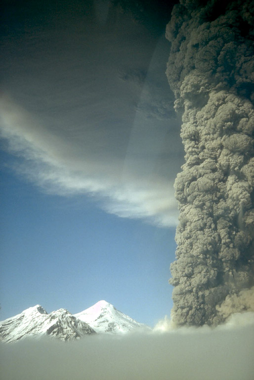
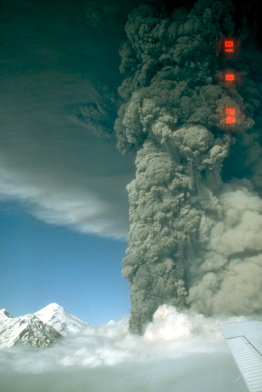
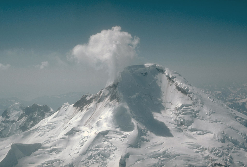
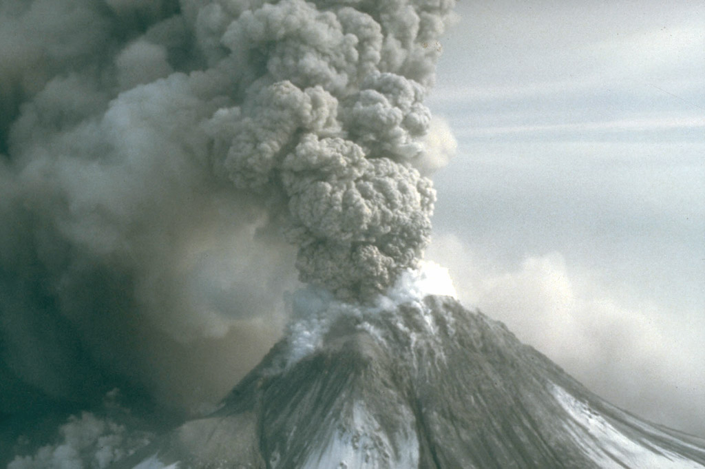
36. Aerial view, looking southeast, at the summit of Redoubt Volcano. Prior to the onset of the 1989 to 1990 eruptions of Redoubt Volcano, melting of the summit crater ice cap caused by heat from rising magma produced a vigorous steam plume. Photograph by H. Twitchell, National Park Service, December 14, 1989.
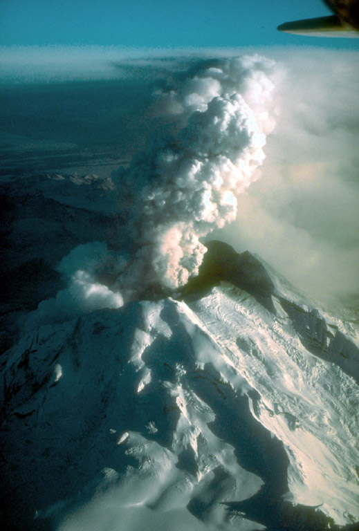
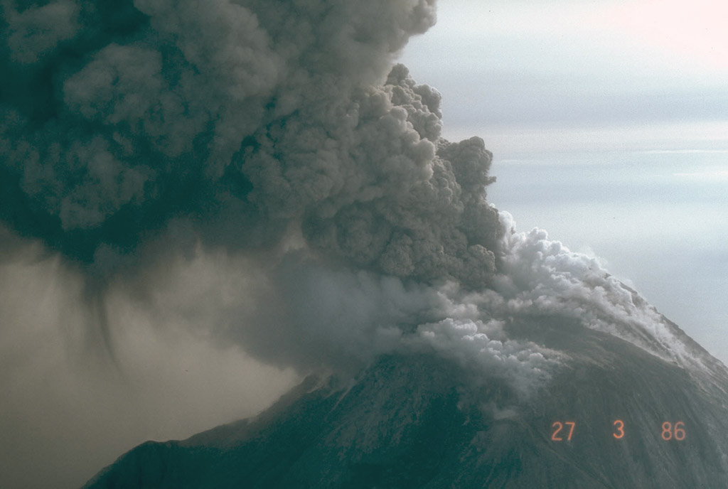
37. Aerial view, looking northeast, of Redoubt Volcano during a continuous, low-level eruption of steam and ash. Photograph by W. White, U.S. Geological Survey, December 18, 1989.
38. Aerial view, looking north, of Redoubt Volcano during a continuous, low-level eruption of steam and ash. Photograph by W. White, U.S. Geological Survey, December 18, 1989.
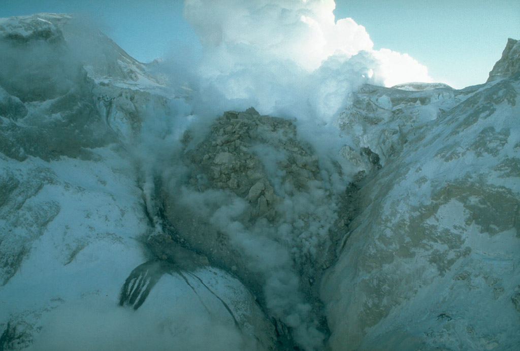
39. The 1989 to 1990 eruptions of Redoubt Volcano were characterized by repeated growth and destruction of lava domes in the summit crater. This view shows the north face of the second largest lava dome, which was destroyed during an explosive eruption on February 15, 1990. Photograph by R. McGimsey, U.S. Geological Survey, February 2, 1990.
40. The 1989 to 1990 eruptions of Redoubt Volcano were characterized by repeated growth and destruction of lava domes in the summit crater. Avalanching of hot debris from disintegrating lava domes caused extensive melting of the glacier draining the summit crater and produced deeply incised channels with steep ice walls. View is to the north. Photograph by T. Miller, U.S. Geological Survey, April 7, 1990.
41. Hot debris avalanching down the steep north flank of Redoubt Volcano during the 1989 to 1990 eruptions mixed with water derived from melted snow and ice to form lahars. These sediment-rich floods carried steaming debris as far as 35 km (22 mi) down the Drift River valley. Photograph by T. Miller, U.S. Geological Survey, February 15, 1990.
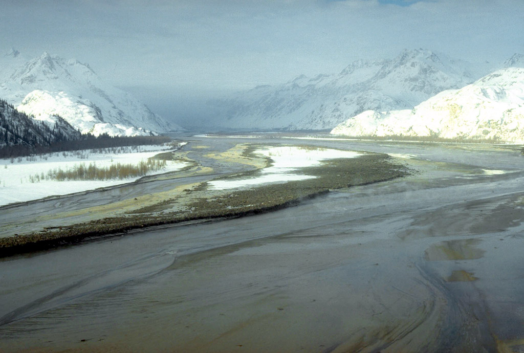
42. Lahars formed during the 1989 to 1990 eruptions of Redoubt Volcano accumulated in the Drift River valley. The largest lahars, such as this one from the February 15, 1990 eruption, covered the valley floor nearly wall to wall and extended more than 35 km (22 mi) to the Cook Inlet. View is to the west. Photograph by T. Miller, U.S. Geological Survey, February 15, 1990.
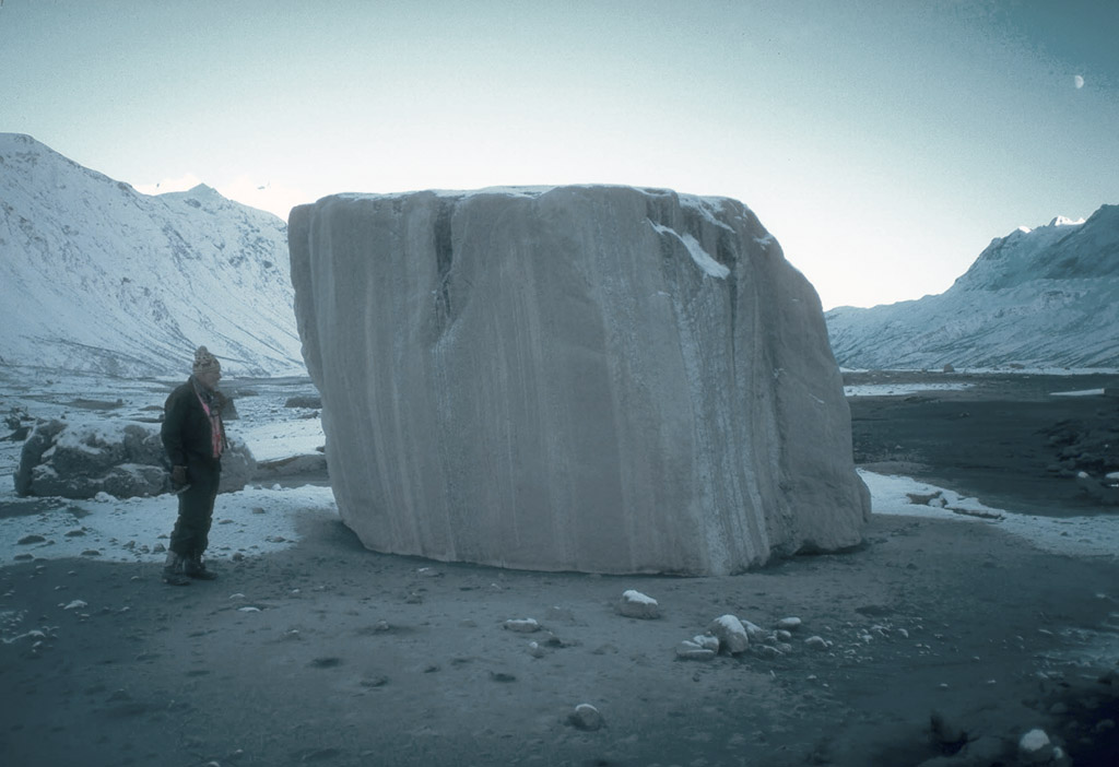
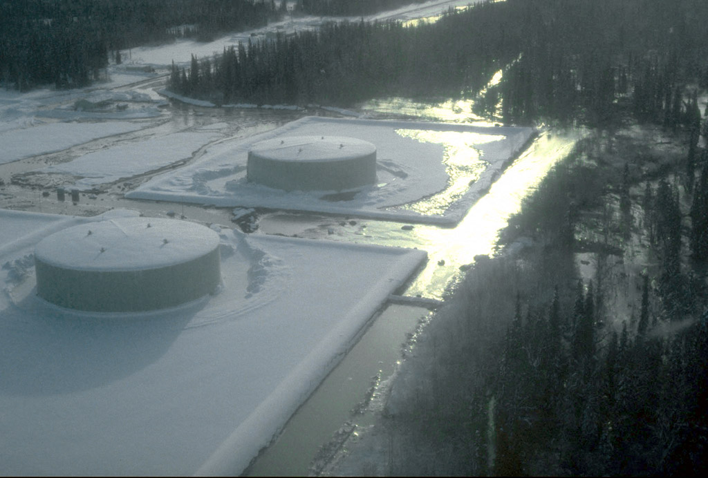
43. Large blocks of glacial ice were carried many kilometers downstream by lahars during the 1989 to 1990 eruptions of Redoubt Volcano. Photograph by T. Miller, U.S. Geological Survey, January 5, 1990.
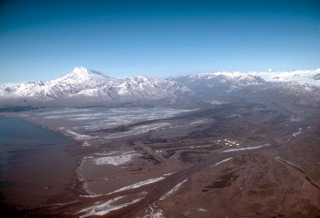
44. One of the principal facilities at risk during the 1989 to 1990 eruptions of Redoubt Volcano was the Drift River Oil Terminal located at the mouth of the Drift River, 35 km (22 mi) northeast of the volcano. This aerial view, looking southwest, shows the 1.9 billionbarrel capacity oil storage tanks. Redoubt Volcano is on the skyline at left. Photograph by R. McGimsey, U.S. Geological Survey, April 13, 1990.
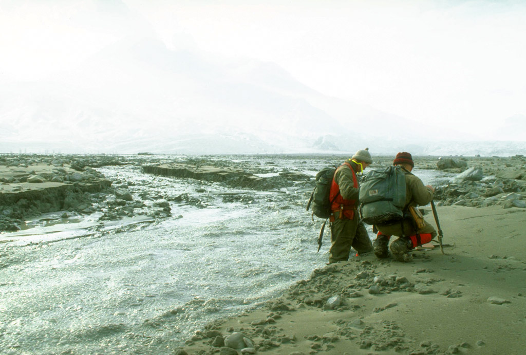
45. The February 15, 1990 eruption of Redoubt Volcano produced a lahar that overtopped the containment berm at the Drift River Oil Terminal but did not damage the storage tanks. Photograph by T. Miller, U.S. Geological Survey, February 15, 1990.
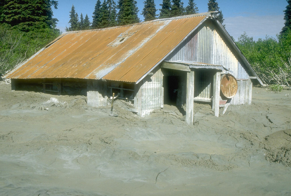
46. Geologists view an unusual flowing mixture of water and ice in the upper Drift River. The flow was produced by a sudden release of impounded water from the upper reaches of the Drift River canyon which drains the summit crater of Redoubt Volcano. Photograph by R. McGimsey, U.S. Geological Survey, March 15, 1990.
47. Lahars from the 1989 to 1990 eruptions of Redoubt Volcano inundated this structure near the mouth of Drift River, 35 km (22 mi) from the volcano. Photograph by C. Gardner, U.S. Geological Survey, June 1, 1990.

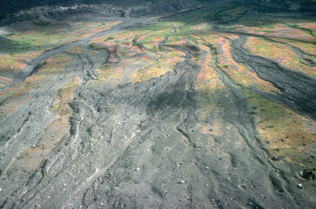
48. Where exposed by subsequent stream downcutting, lahar deposits from the 1989 to 1990 eruptions of Redoubt Volcano consisted of layers of sand- to boulder-sized debris. Photograph by R. McGimsey, U.S. Geological Survey, June 15, 1990.
49. Aerial view, looking southwest, of the Drift River valley following the 1989 to 1990 eruptions of Redoubt Volcano. Two bedrock islands (informally called the "Dumbbell Hills ") are visible at bottom center. Lahar deposits cover the valley floor. Photograph by C. Gardner, U.S. Geological Survey, June 28, 1990.

50. During the eruption of Redoubt Volcano on December 15, 1989, ), hot ejecta falling onto the upper flanks of the volcano produced avalanches of snow, ice, meltwater, and pyroclastic debris to form an unusual ice-rock diamict. In this view, the diamict is approximately 4.5 m (15 ft) thick and caps ice of the piedmont lobe of Drift glacier . Overlying the ice-rock diamict are sand to gravel-sized pyroclastic flow deposits from eruptions between January and March of 1990. Photograph by C. Gardner, U.S. Geological Survey, May 19, 1990.
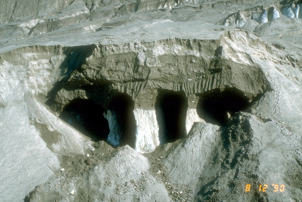
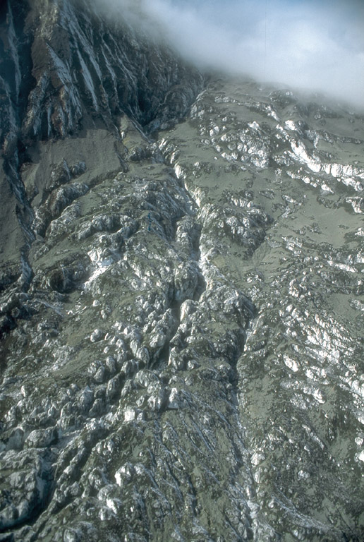
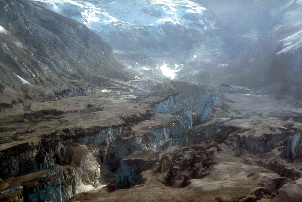
51. Oblique aerial view of the upper portion of the piedmont lobe of Drift glacier. White towers of glacial ice are capped by about 10 m (33 ft) of ice-rock diamict (dark brown) from the December 15, 1989, eruption of Redoubt Volcano. The ice-rock diamict is overlain by tan, sand to gravel-sized pyroclastic flow and lahar deposits from the more than 20 eruptions that occurred through April 21, 1990. Photograph by C. Neal, U.S. Geological Survey, August 12, 1990.

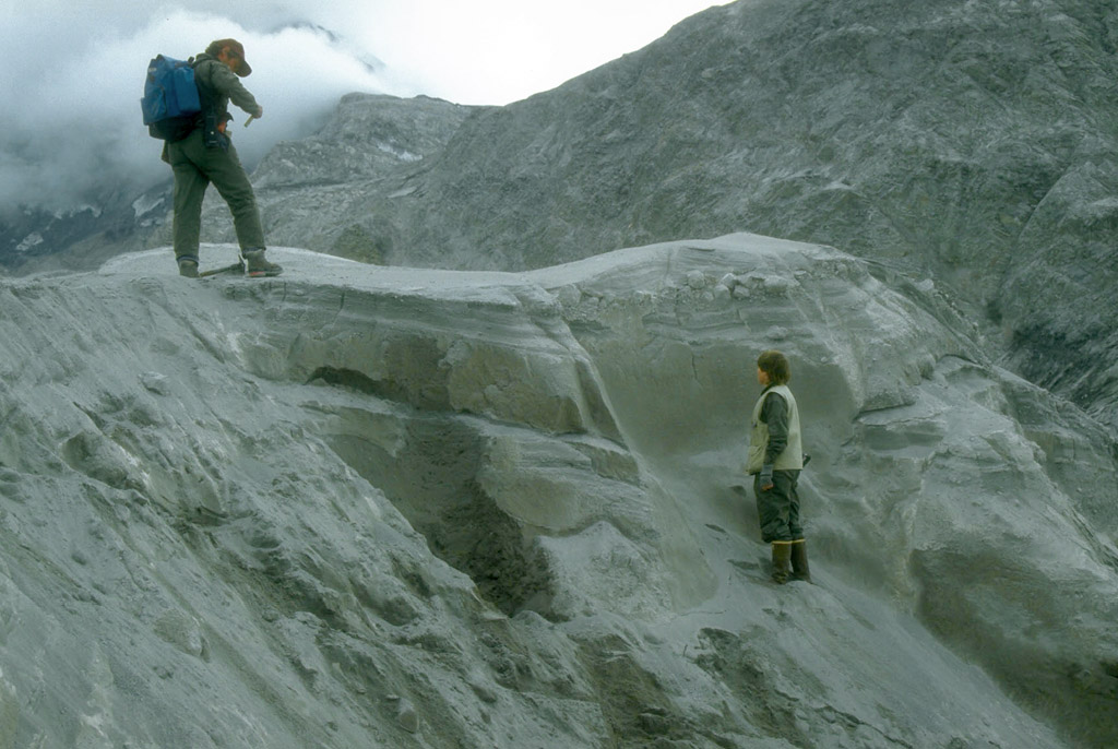
52. Geologists examining steaming pyroclastic-flow deposits from the March 23, 1990, eruption of Redoubt Volcano that came to rest on the margin of the piedmont lobe of Drift glacier. Darker areas were wet and reflected melting of glacial ice incorporated into the deposit. The collapse pits seen here resulted from funneling of debris into crevasses and holes in the buried surface of the glacier. Photograph by R. McGimsey, U.S. Geological Survey, March 23, 1990.
53. Geologists examining 1990 pyroclastic-flow and pyroclastic-surge deposits on the surface of the piedmont lobe of Drift glacier at Redoubt Volcano. Photograph by C. Gardner, U.S. Geological Survey, August 3, 1990.
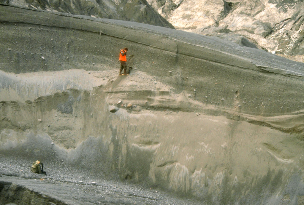
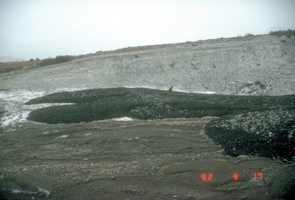
54. Geologist examining 1990 pyroclastic-flow and pyroclastic-surge deposits on the surface of the piedmont lobe of Drift glacier at Redoubt Volcano. Photograph by C. Gardner, U.S. Geological Survey, July 20, 1991.
55. Pyroclastic-flow deposits from the April 15 (lower two thirds of section) and April 21 (upper one third of section), 1990 eruptions of Redoubt Volcano exposed in a gully along the western margin of the piedmont lobe of Drift glacier. Shovel at base of section shows scale. Photograph by C. Neal, U.S. Geological Survey, June 7, 1990.

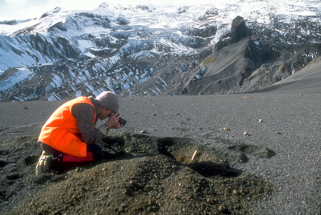
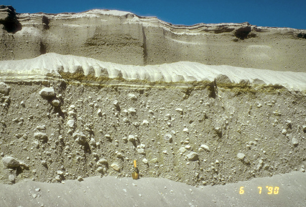
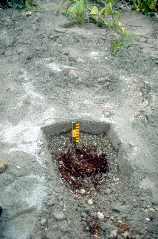
56. Steam billows from newly exposed, hot pyroclastic debris in the canyon draining the summit crater of Redoubt Volcano. More than 30 meters (100 ft) of coarse sand to boulder sized material accumulated in this canyon during the 1989 to 1990 eruptions of the volcano. Subsequent downcutting by meltwater occasionally caused steam explosions as water came into contact with hot pyroclastic material. Photograph by C. Gardner, U.S. Geological Survey, July 16, 1990.
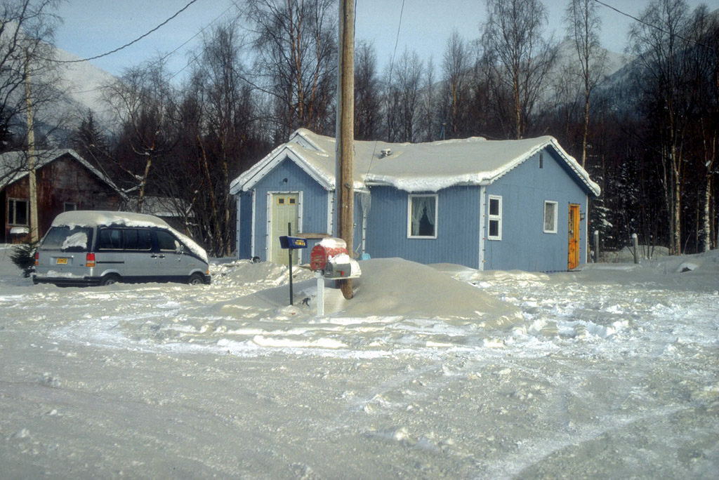
57. Tephra-fall deposits from some of the larger eruptions of Redoubt Volcano between December 15, 1989 and April 21, 1990. Above the dark vegetation mat is about 8 cm (3 in) of gravel-sized pumice and lithic lapilli from the December 15, 1989 eruption. This is overlain by about 8 cm (3 in) of coarse ash from several subsequent eruptions in 1990. Ruler, 15 cm (6 in) long, shows scale. Photograph by R. McGimsey, U.S. Geological Survey, August 20, 1990.
58. Gray ash from the February 21, 1990, eruption of Redoubt Volcano blankets the snow in Indian, Alaska, a community about 32 km (20 mi) southeast of Anchorage and 200 km (124 mi) northeast of Redoubt Volcano. Photograph by R. McGimsey, U.S. Geological Survey, February 21, 1990.

59. The final lava dome of the 1989 to 1990 series of eruptions of Redoubt Volcano was emplaced in the summit crater by summer, 1990. It measures approximately 350 to 400 m (980 to 1,300 ft) across and represents an estimated 10 million cubic meters (353 million cubic feet) of material. Photograph by C. Neal, U.S. Geological Survey, July 17, 1990.
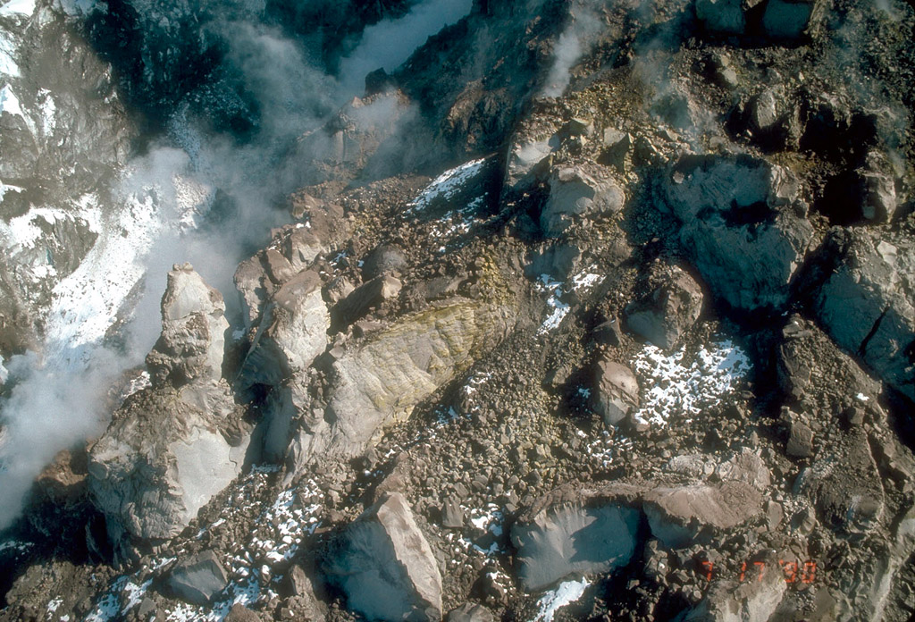
60. Aerial view of the highly irregular, steep north face of the final lava dome of the 1989 to 1990 series of eruptions of Redoubt Volcano. The surface consists of blocks of slightly vesicular to dense andesite lava up to 30 m (100 feet) across. Yellow sulfur deposits are visible on a block of lava at center of view. Photograph by C. Neal, U.S. Geological Survey, July 17, 1990.

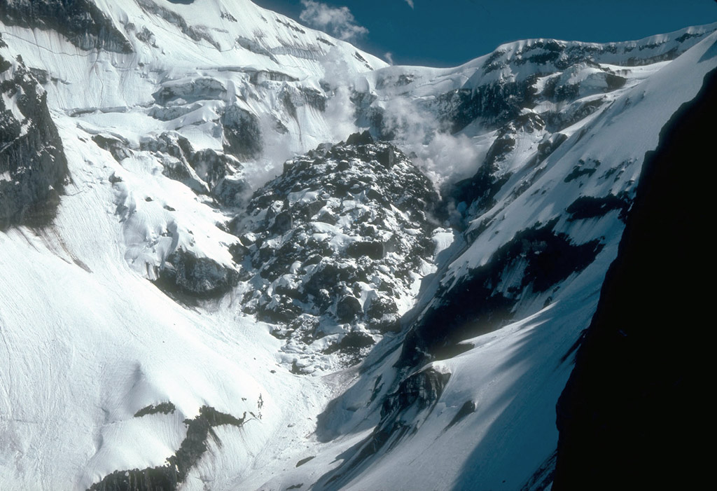
61. The south face of the final lava dome of the 1989 to 1990 series of eruptions of Redoubt Volcano as it appeared during the waning phases of eruption. A fractured lobe of blocky lava is visible at center. Steam from the interaction of meltwater with hot rock billows from the margins of the lava dome. Remnants of glacial ice with a coating of gray ash surround the dome. Photograph by C. Gardner, U.S. Geological Survey, June 1, 1990.
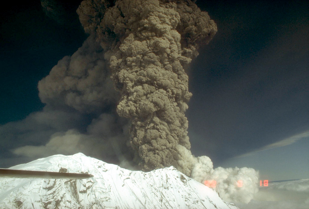
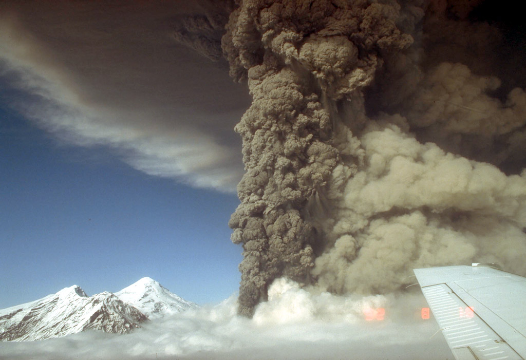
62. Final lava dome of the 1989 to 1990 series of eruptions of Redoubt Volcano as it appeared approximately one year after the end of the eruption. It measures approximately 350 to 400 m (980 to 1,300 ft) across and represents an estimated 10 million cubic meters (353 million cubic feet) of material. By the time this photograph was taken, snow had accumulated on the cooling lava blocks. Locally, hydrothermal activity continued to produce intermittent steam plumes. View is to the south. Photograph by R. McGimsey, U.S. Geological Survey, June 21, 1990.

63. Ascending eruption cloud from Redoubt Volcano and its reflection in the waters of Cook Inlet. View is to the west from the Kenai Peninsula. Photograph by J. Warren, April 21, 1990.
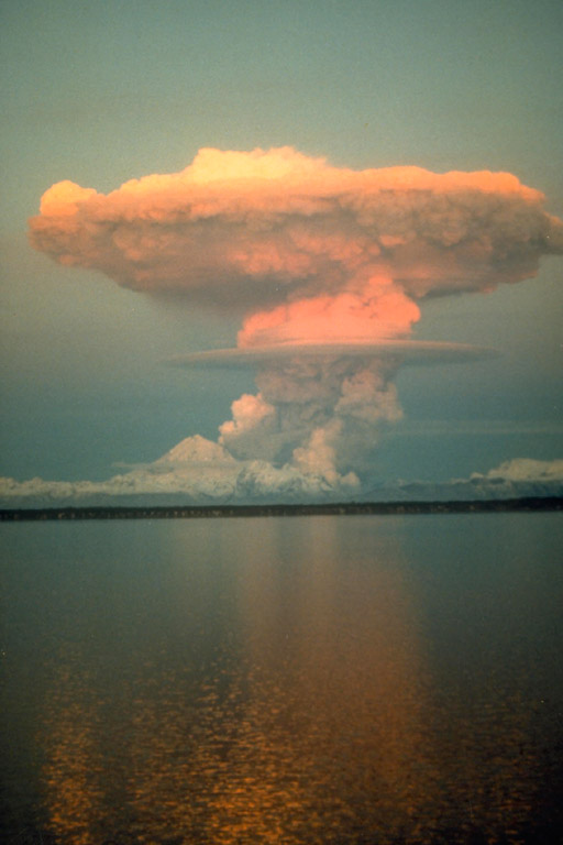
64. Ascending eruption cloud from Redoubt Volcano and its reflection in the waters of Cook Inlet. View is to the west from the Kenai Peninsula. Photograph by J. Warren, April 21, 1990.
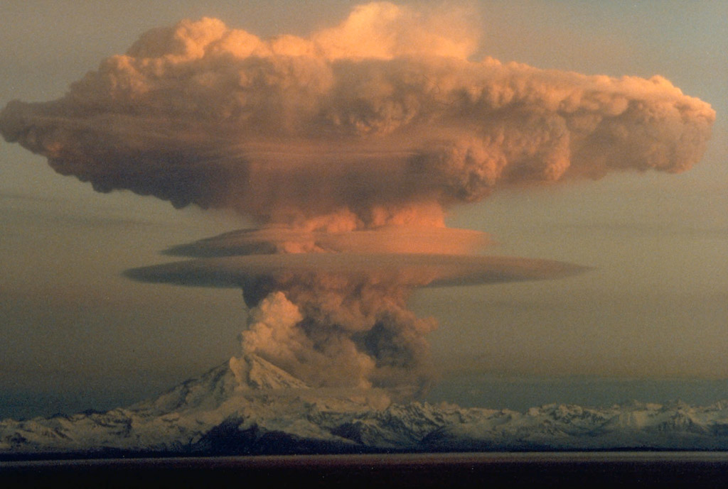
65. Ascending eruption cloud from Redoubt Volcano as viewed to the west from the Kenai Peninsula. The mushroom-shaped plume rose from avalanches of hot debris (pyroclastic flows) that cascaded down the north flank of the volcano. A smaller, white steam plume rises from the summit crater. Photograph by R. Clucas, April 21, 1990.
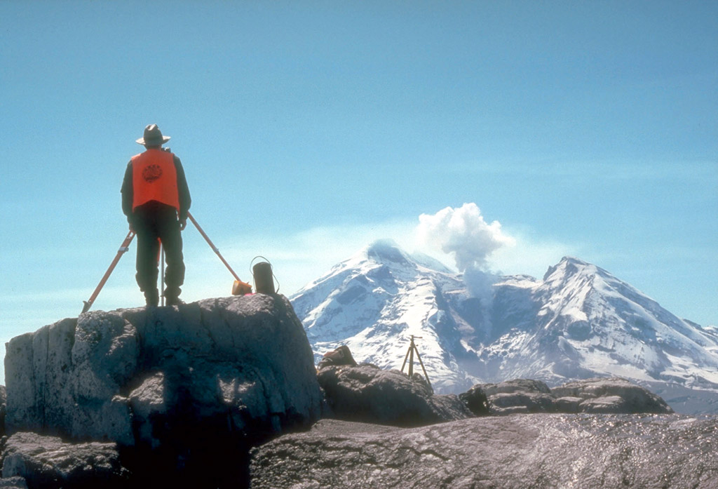
66. Geologist using a laser surveying instrument to measure distances to reflective prisms or targets installed on the flanks of Redoubt Volcano in the distance. Minute changes in distances to the targets can indicate ground deformation that may be related to subsurface magma movement. View is to the south. Photograph by R. McGimsey, May 4, 1990.

67. Geologist setting up GPS (Global Positioning System) instrumentation on the north flank of Redoubt Volcano. The GPS receiver calculates an extremely accurate position on the Earth's surface through satellite-based triangulation. View is to the northeast. Photograph by R. McGimsey, June 21, 1991.
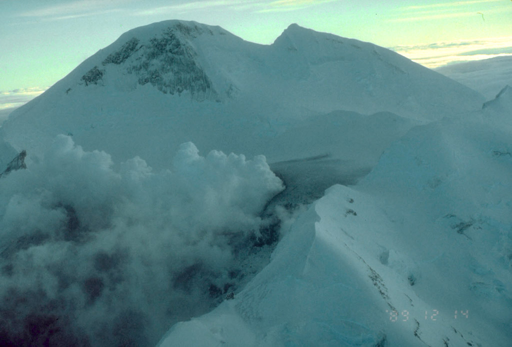
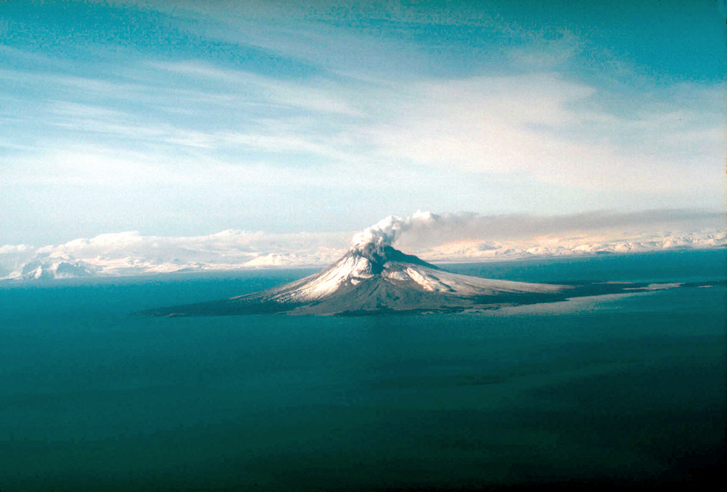
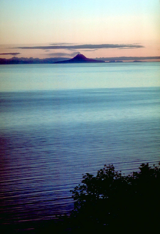
69. Iliamna Volcano, 3,053 m (10,016 ft) high, as seen at sunset from the Kenai Peninsula. Iliamna Volcano is one of the four Cook Inlet volcanoes monitored by the Alaska Volcano Observatory. View is to the west. U.S. Geological Survey photograph, 1977.
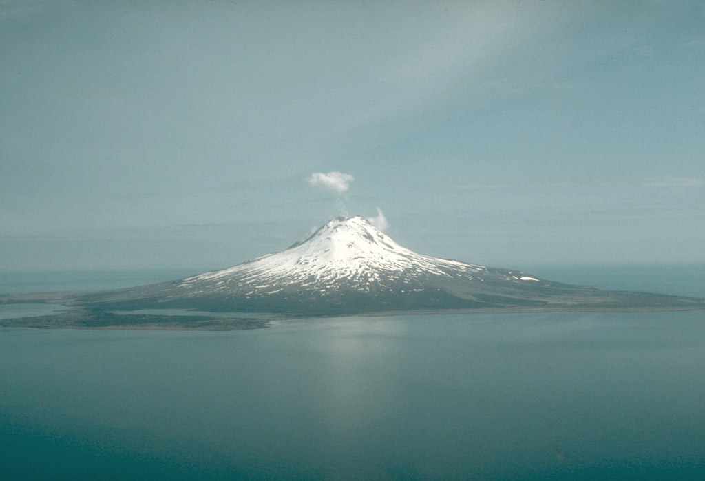
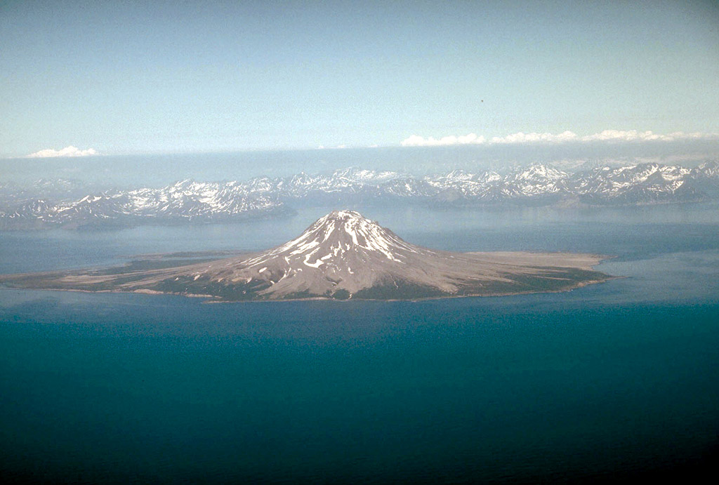
70. Iliamna Volcano, 3,053 m (10,016 ft) high, as seen from Augustine Island, 75 km (47 mi) to the south. Iliamna Volcano is one of the four Cook Inlet volcanoes monitored by the Alaska Volcano Observatory. Photograph by R. McGimsey, U.S. Geological Survey, July 29, 1994.
72. Steam rising from the summit lava dome complex at 1,282-m (4,206 ft)-high Augustine Volcano. Note the symmetrical apron of pyroclastic debris that extends from the summit to sea level. View is to the east. Photograph by T. Miller, U.S. Geological Survey, June 6, 1989.
73. A symmetrical apron of pyroclastic debris extends from the summit of 1,282-m (4,206 ft)-high Augustine Volcano to sea level. The western shore of Cook Inlet can be seen in the distance. View is to the west. Photograph by C. Neal, U.S. Geological Survey, June 4, 1990.
74. Steam plume rising from 1,282-m (4,206 ft)-high Augustine Volcano as seen from Anchorage, Alaska, at sunset. Redoubt Volcano is on the skyline at right. View is to the southwest. Photograph by B. Gamble, U.S. Geological Survey, August 30, 1986.
75. Augustine Volcano, 1,282 m (4,206 ft) high, seen at sunset from near Homer, Alaska. Steam and volcanic gas trails downwind from the summit lava dome complex. View is to the west. U.S. Geological Survey photograph, 1977.
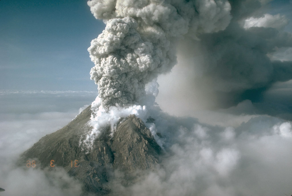
76. A vigorous eruption column rising over the summit of 1,282-m (4,206 ft)-high Augustine Volcano. At the time of this photograph, a new lava dome was growing at the summit. At upper right, ash can be seen falling from the eruption cloud as it travels downwind away from the volcano. Photograph by M.E. Yount, U.S. Geological Survey, March 31, 1986.

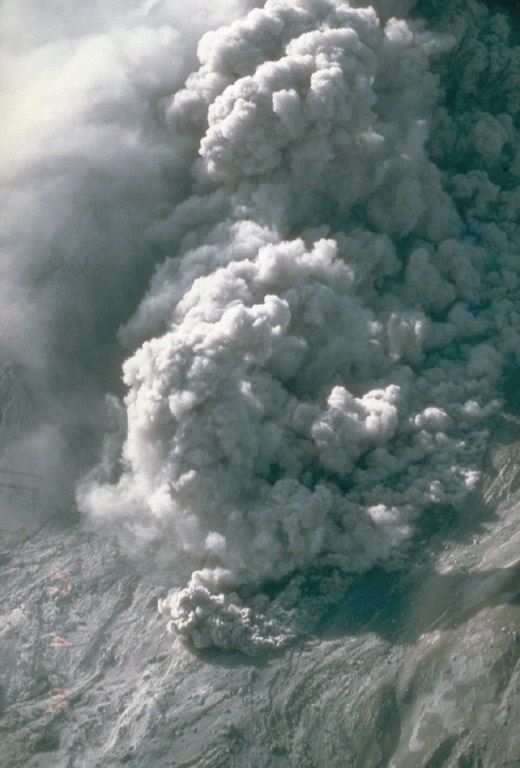
77. A vigorous eruption column rising over the summit of 1,282-m (4,206 ft)-high Augustine Volcano. Photograph by M.E. Yount, U.S. Geological Survey, March 31, 1986.

78. A vigorous eruption column rising over the summit of 1,282-m (4,206 ft)-high Augustine Volcano. Steam can be seen rising from the margins of the summit crater. U.S. Geological Survey photograph, March 27, 1986.
79. A vigorous eruption column rising over the summit of 1,282-m (4,206 ft)-high Augustine Volcano. Steam can be seen rising from the margins of the summit crater and from other areas where groundwater has been heated by the eruption. Photograph by M.E. Yount, U.S. Geological Survey, March 27, 1986.
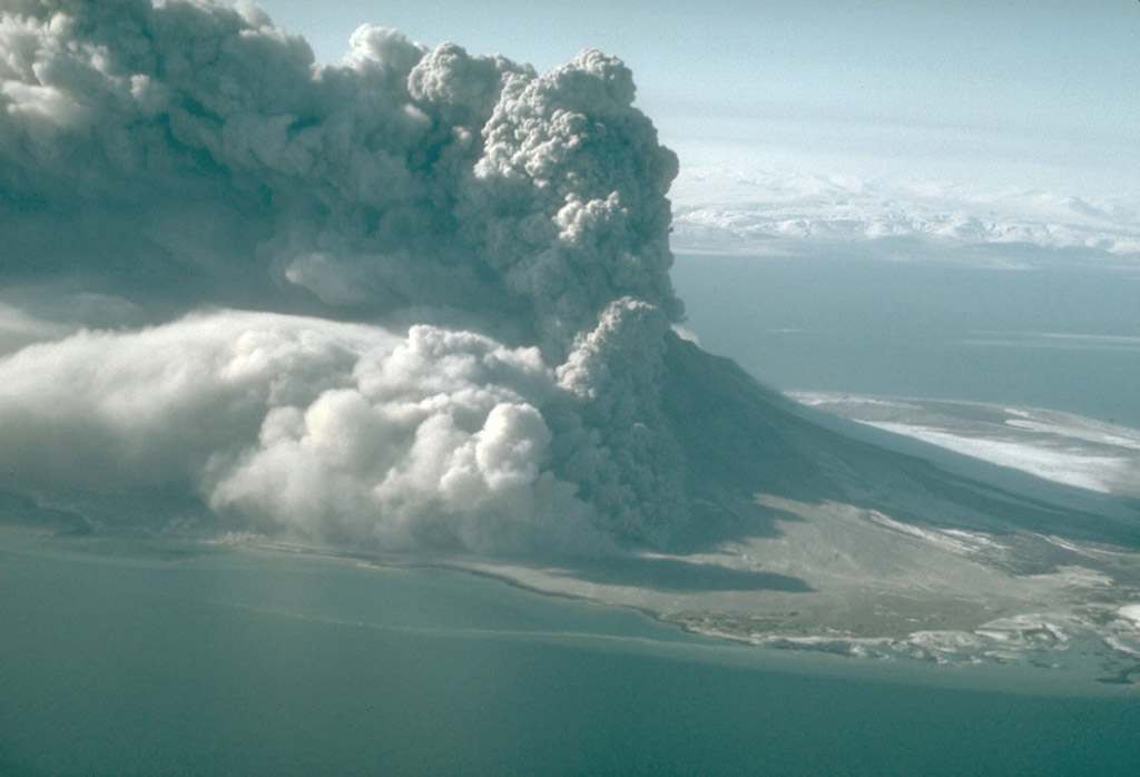
80. A vigorous eruption column rising over the summit of 1,282-m (4,206 ft)-high Augustine Volcano. Ash is falling in dark tendrils that extend downward from the eruption cloud. U.S. Geological Survey photograph, March 27, 1986.
81. A pyroclastic flow sweeping down the north flank of 1,282-m (4,206 ft)-high Augustine Volcano. Photograph by M.E. Yount, U.S. Geological Survey, March 27, 1986.
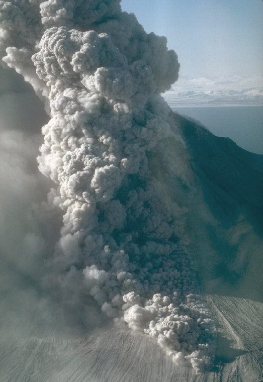
82. A pyroclastic flow sweeping down the north flank of 1,282-m (4,206 ft)-high Augustine Volcano. A light-colored ash cloud can be seen rising from the moving flow. Photograph by M.E. Yount, U.S. Geological Survey, March 30, 1986.
83. A pyroclastic flow sweeping down the north flank of 1,282-m (4,206 ft)-high Augustine Volcano. The eruption cloud is carried to the east by prevailing winds. Photograph by M.E. Yount, U.S. Geological Survey, March 30, 1986.
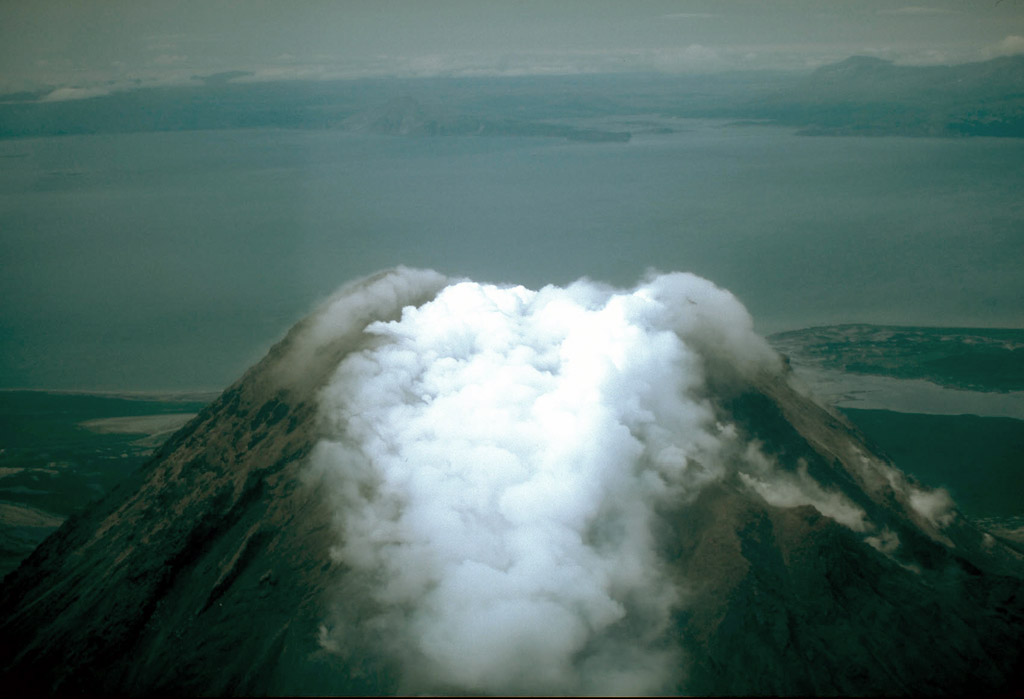
84. Steam rising from the cooling lava dome fills the summit crater at Augustine Volcano. U.S. Geological Survey photograph, July 24, 1986.
85. Steam rising from the summit lava dome complex of Augustine Volcano. In this picture, the lava dome, formed in 1976, is enclosed within a steep-walled crater roughly 500 m (1,640 ft) across and breached to the north. This crater formed during an explosive eruption in 1964. The surface of the lava dome consists of rough, irregular blocks of andesite lava. A coating of fine ash is visible. Photograph by C. Nye, Alaska Division of Geological and Geophysical Surveys, 1982.
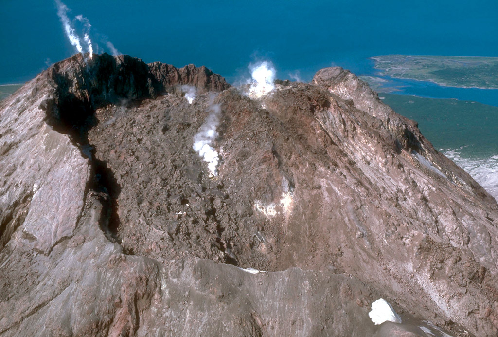
86. The summit lava dome complex at Augustine Volcano. Steam rises from the base of the lava dome formed in 1986. U.S. Geological photograph, August 24, 1986.

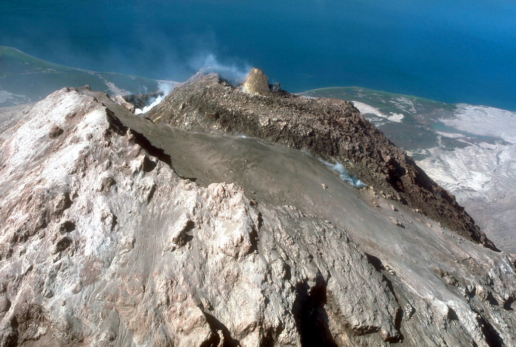
87. The summit lava dome complex at Augustine Volcano. The apron of pyroclastic debris extending from the lava dome accumulated during the 1986 eruptions. View is to the south. Photograph by T. Miller, U.S. Geological Survey, April 28, 1986.

88. Geologist examining pyroclastic-flow deposits from the 1986 eruptions of Augustine Volcano. Photograph by T. Miller, U.S. Geological Survey, May 6, 1986.
89. Geologist sampling blocks from the lava dome formed in 1986 at Augustine Volcano. Photograph by T. Miller, U.S. Geological Survey, May 6, 1986.
90. A large fragment of the lava dome that was carried about 5 km (3 mi) in a pyroclastic flow during the 1986 eruptions of Augustine Volcano. Photograph by M.E. Yount, U.S. Geological Survey, May 6, 1986.

91. A large fragment of the lava dome in pyroclastic-flow deposits from the 1986 eruptions of Augustine Volcano. The 1282-m (4,206 ft)-high volcano is in the background. Hammer shows scale. U.S. Geological Survey photograph, April 19, 1986.

92. Apron of pyroclastic-flow deposits emplaced during the 1986 eruptions of 1282-m (4,206 ft)-high Augustine Volcano. In the background is the steaming summit lava dome complex. U.S. Geological Survey photograph, April 30, 1986.
93. Light-colored pyroclastic-flow deposits from the 1986 eruptions of Augustine Volcano. Pyroclastic flows entered the sea along the northeast shoreline of the island, visible in this view. U.S. Geological Survey photograph, August 22, 1986.
94. Debris-avalanche deposits from the 1883 eruption of Augustine Volcano entered the sea along the north shoreline of the island (darker area at top of photograph.) Light-colored areas are pyroclastic-flow deposits from the 1976 and 1986 eruptions U.S. Geological Survey photograph, April 25, 1986.
95. Debris avalanche deposits from the 1883 eruption of Augustine Volcano entered the sea along the north shoreline of the island forming hummocky topography. U.S. Geological Survey photograph, April 27, 1986.
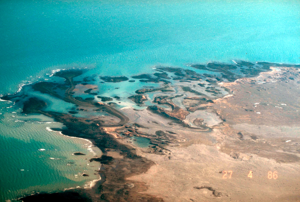
96. Debris avalanche deposits from the 1883 eruption of Augustine Volcano form small hills and islets at Burr Point on the north shore of Augustine Island. Photograph by S. McNutt, Geophysical Institute, University of Alaska, July 31, 1992.
97. View of the southwest flank of Augustine Volcano. Note the steep-sided lava dome complex forming the summit of the volcano. Photo by R. McGimsey, U.S. Geological Survey, July 29, 1994.