Selected Images of the Pu‘u ‘O‘o–Kupaianaha Eruption, 1983–1997 Album
The 100 images in this CD-ROM have been selected from the collections of the Hawaiian Volcano Observatory as enduring favorites of the staff, researchers, media, designers, and the public over time. They represent photographs of a variety of geological phenomena and eruptive events, chosen for their content, quality of exposure, and aesthetic appeal. The number was kept to 100 to maintain the high resolution desirable.
Since 1997, digital imagery has been the main method of photographically documenting the eruption. Many of these photos, from 1998 to the present, can be viewed on our website: http://hvo.wr.usgs.gov/kilauea/update/archive/.
Episode numbers are given as E-numbers in parentheses before each caption that pertains to the Pu‘u ‘O‘o-Kupaianaha eruption. Hawaiian words and place names are listed below to facilitate searching.
All images included in this collection are owned by the U.S. Geological Survey, Hawaiian Volcano Observatory, and are in the public domain. Therefore, no permission or fee is required for their use. Please include photo credit for the photographer and the U.S. Geological Survey. We assume no responsibility for the modification of these images.
Hawaiian words and place names used in the captions
‘a‘a
Hakuma (horst)
Halemaumau (Crater)
Hawai‘i
heiau
Holei sea arches
Kaimu (Bay, beach)
Kalalua
Kalapana
Kamoamoa
Kapa‘ahu
Kilauea (Volcano, caldera)
Kupaianaha
Kupapa‘u (Point, village)
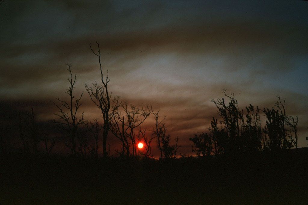
Lae‘apuki
lei
limu o Pele
Lokelani Street
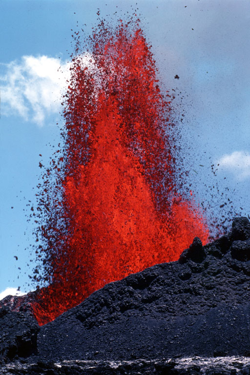
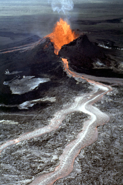
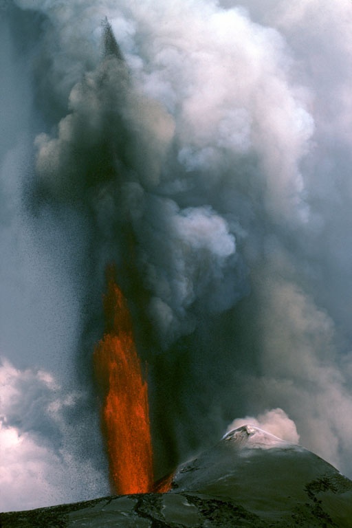
Mauna Kea
Mauna Loa
Napau Crater
‘ohi‘a
Pa‘ao
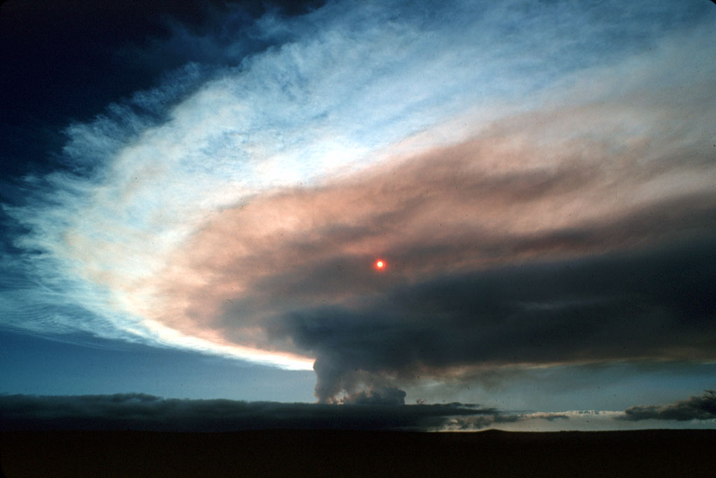
pahoehoe
Pauahi Crater
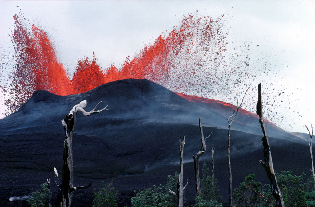
Poupou
Pulama pali
Punalu‘u
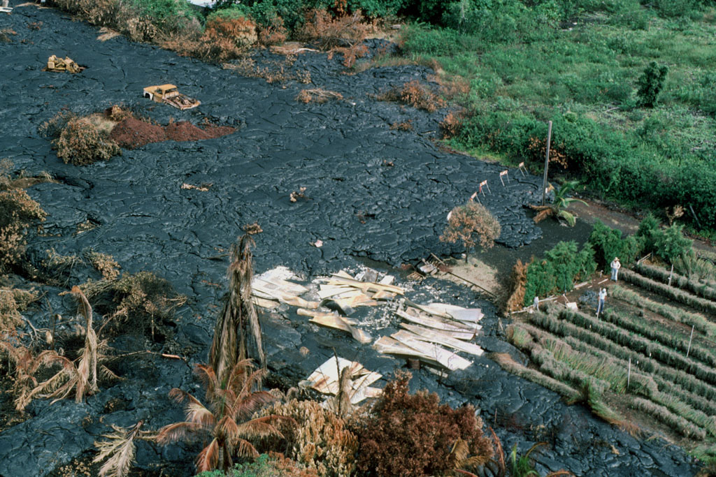
Pu‘u Halulu
Pu‘u Kahaualea
Pu‘u Kamoamoa
Pu‘u ‘O‘o
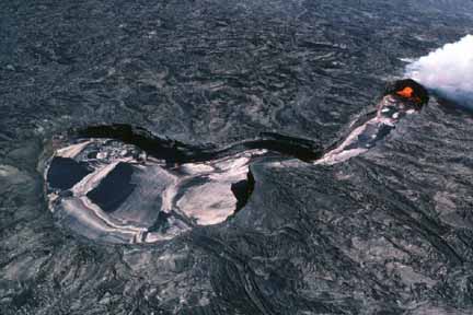
Uwekahuna (bluff, overlook)
Waha‘ula (Visitor Center, heiau)
Wai‘akolea Park
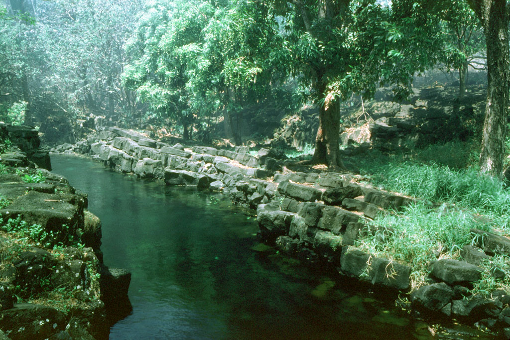
Click on the images to get a larger version. Episode numbers are given in parentheses after each caption number.

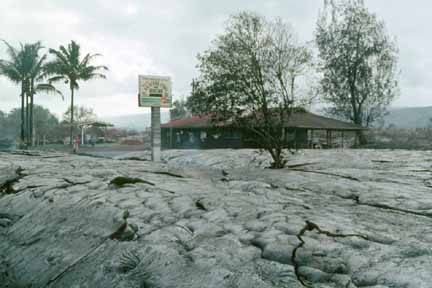
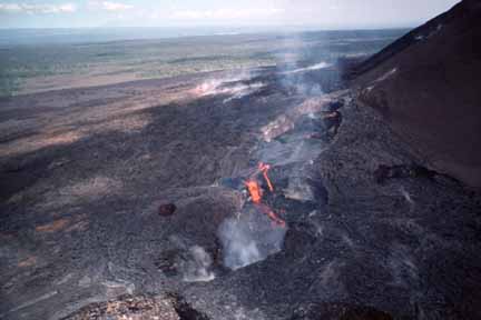
1 (E-1). Aerial view, from the southwest, of flow near Pu‘u Kamoamoa, a prehistoric cone approximately 3,500 m northeast of Napau Crater, in Kilauea’s middle east rift zone. Episode 1 (January 3–23, 1983) was characterized by eruptions from fissures several hundred meters long. The fountains from these eruptions produced a series of low spatter ramparts (photo by J.D. Griggs, 1/3/83, JG132A) (picture #001).

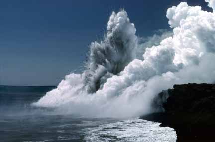
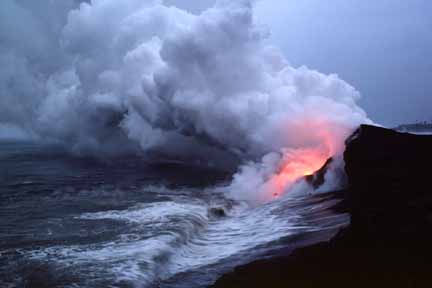
2 (E-1). Aerial view of fountains from eruptive fissures south of Pu‘u Kahaualea, approximately 2,350 m northeast of what is now Pu‘u ‘O‘o. Note single ‘ohi‘a tree burning in front of the fissures (photo by J.D. Griggs, 1/5/83, JG349) (picture #002).
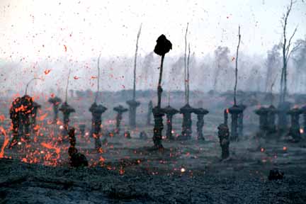
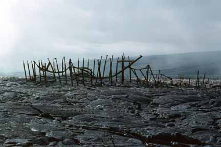
3 (E-1). Forest of lava trees resulting from eruption of a 1-km-line of vents east of Pu‘u Kahaualea. The bulbous top of each lava tree marks the high stand of the lava flow as it spread through the trees. As the fissure eruption waned, the flow continued to spread laterally; its surface subsided, leaving pillars of lava that had chilled against tree trunks. Spattering is from fissure out of view to the left. Note blob of spatter adhering to the top of the stripped ‘ohi‘a tree (photo by J.D. Griggs, 1/7/83, JG653) (picture #003).
4 (E-2). Arching fountain approximately 10 m high issuing from the western end of the 0740 vents, a series of spatter cones 170 m long, south of Pu‘u Kahaualea. Episodes 2 and 3 were characterized by spatter and cinder cones, such as Pu‘u Halulu, which was 60 m high by episode 3 (photo by J.D. Griggs, 02/25/83, JG928) (picture #004).
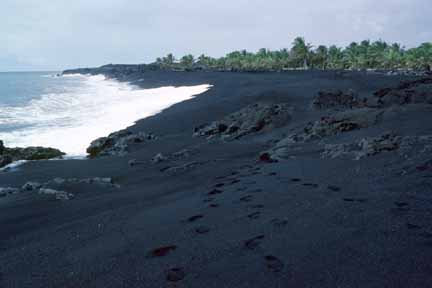
5 (E-4). Lava boulder large enough to fill the back of a pickup truck rolls off the top of an ‘a‘a flow in Royal Gardens subdivision. Pu‘u ‘O‘o was now the primary vent (photo by J.D. Griggs, 6/16/83, JG2236) (picture #005).

6 (E-4). Surging flow front traveling approximately 33 m per minute down the central channel of ‘a‘a flow west of Royal Gardens subdivision. The flow was erupted from Pu‘u ‘O‘o during episode 4 (photo by R.W. Decker, 6/16/83, RD68309) (picture #006).

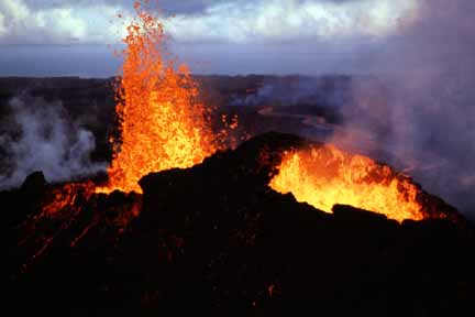
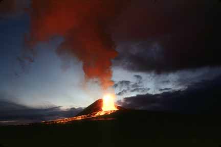
7 (E-5). View at dusk of the young Pu‘u ‘O‘o cinder-and-spatter cone, with fountain approximately 40 m high, during episode 5 (photo by G.E. Ulrich, 6/29/83, GU6830A) (picture #007).
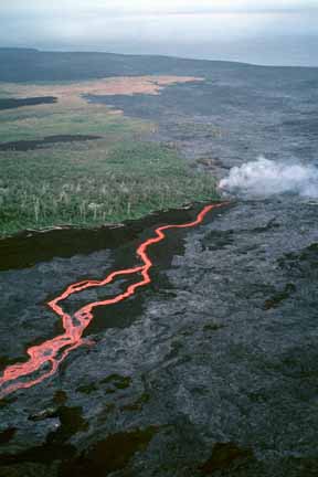
8 (E-5). Aerial view, to the northwest, of channelized pahoehoe flow from Pu‘u ‘O‘o. The flow moved southeastward over the sloping terrain and entered Royal Gardens subdivision, destroying seven homes and cutting off four from road access (photo by J.D. Griggs, 7/1/83, JG2451) (picture #008).
9 (E-5). Aerial view, at dusk, of Pu‘u ‘O‘o. During episode 5, Pu‘u ‘O‘o had two adjacent vents, separated by a wall of spatter (photo by J.D. Griggs, 7/1/83, JG2430) (picture #009).
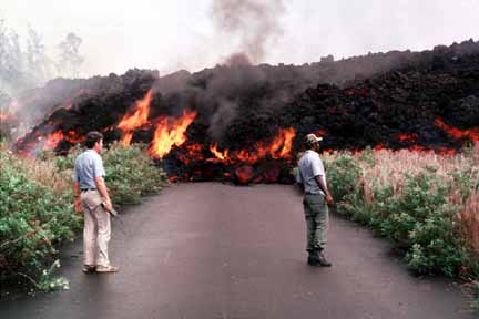
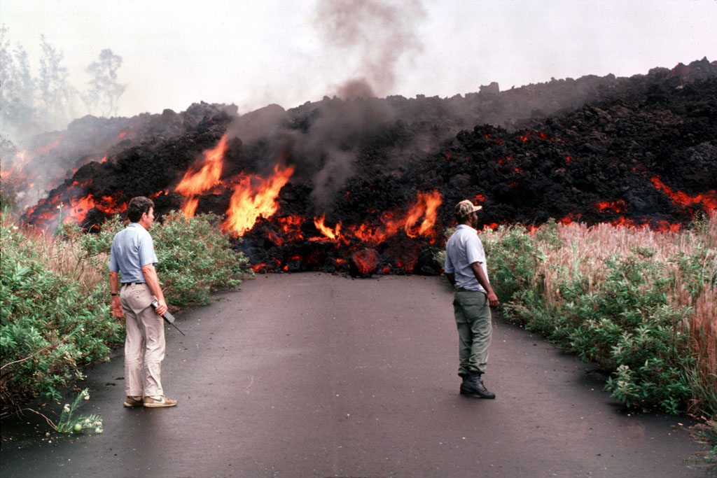
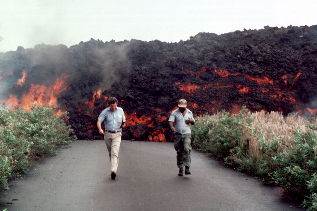
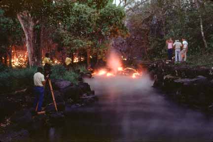
10 (E-5). Concerned scientists observe an ‘a‘a flow from Pu‘u ‘O‘o as it advances down a street in Royal Gardens subdivision (photo by J.D. Griggs, 7/2/83, JG2511) (picture #010).

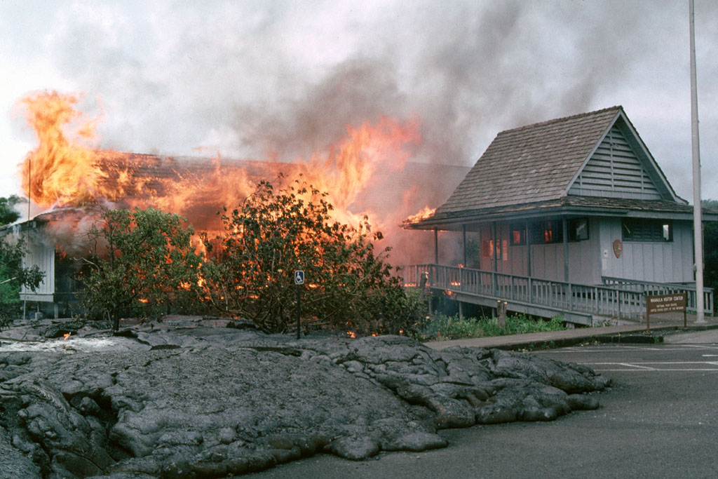
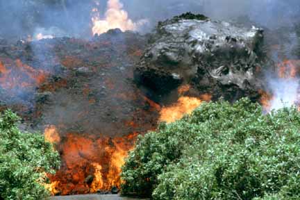
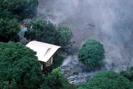
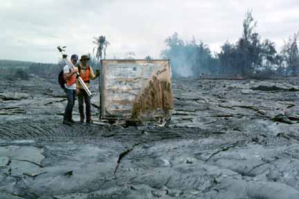
11 (E-5). Scientists pace out and mark known distances in front of the advancing flow to document its speed.
The top of an ‘a‘a flow rides on the underlying molten mass and rolls over it like a tractor’s tread, advancing to the front of the flow. (photo by J.D. Griggs, 7/2/83, JG2514) (picture #011).

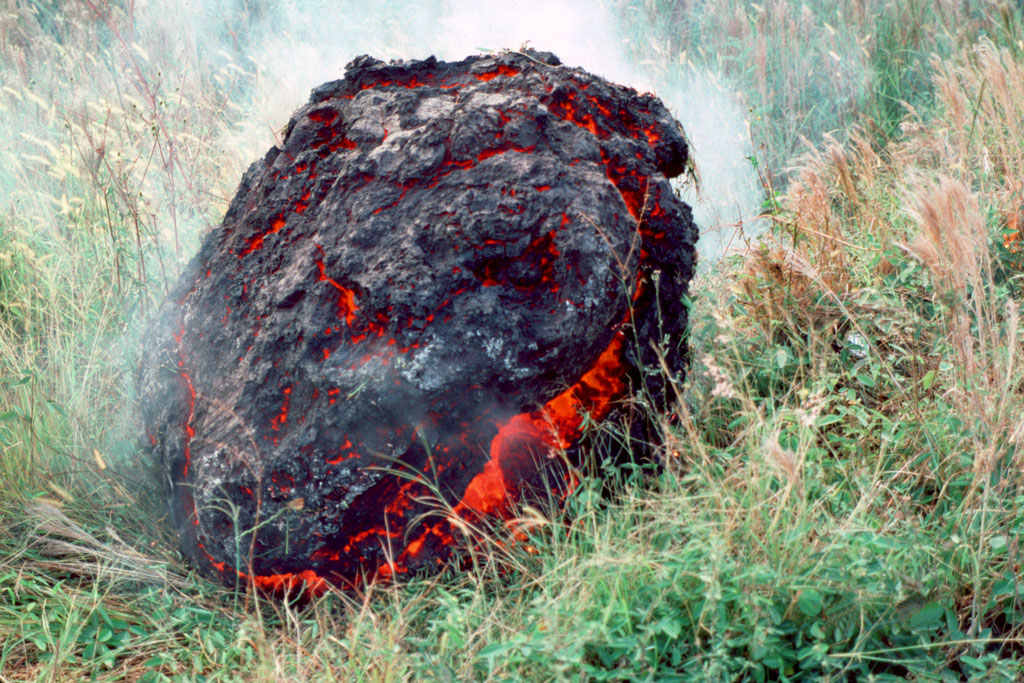
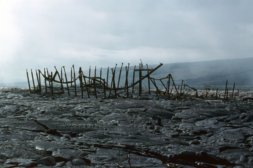
12 (E-5). Accretionary lava ball comes to rest on the grass after rolling off the top of an ‘a‘a flow in Royal Gardens subdivision. Accretionary lava balls form as viscous lava is molded around a core of already solidified lava (photo by J.D. Griggs, 7/2/83, JG2562) (picture #012).
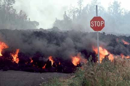
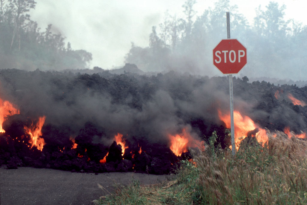
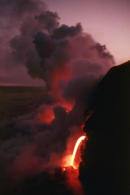
13 (E-5). ‘A‘A flow approaches stop sign in Royal Gardens subdivision (photo by J.D. Griggs, 7/2/83, JG2551) (picture #013).
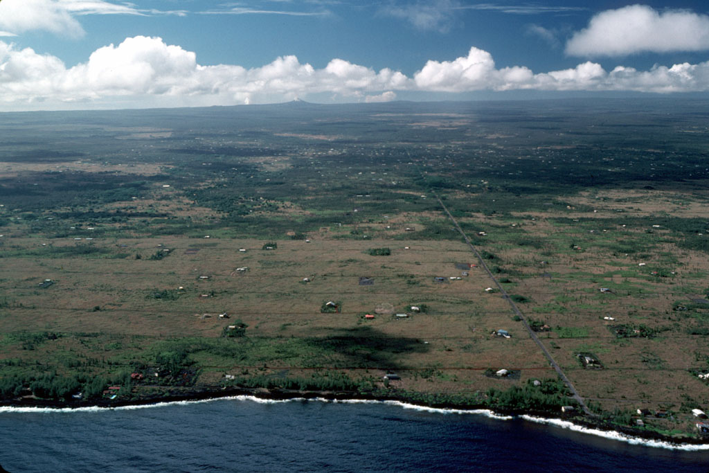
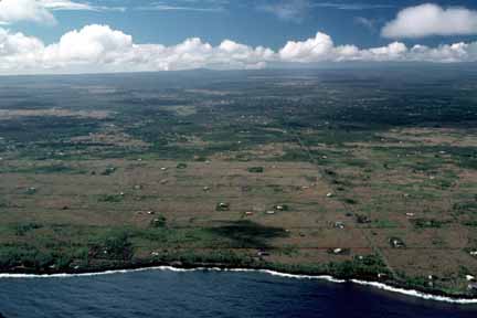
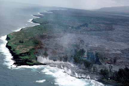
14 (E-8). Low fountain, approximately 50 m high, from Pu‘u ‘O‘o, viewed from the north. Lava issuing from the breach in the northeast rim of the crater produced an ‘a‘a flow that extended for more than 4 km (photo by J.D. Griggs, 9/6/83, JG2879) (picture #014).
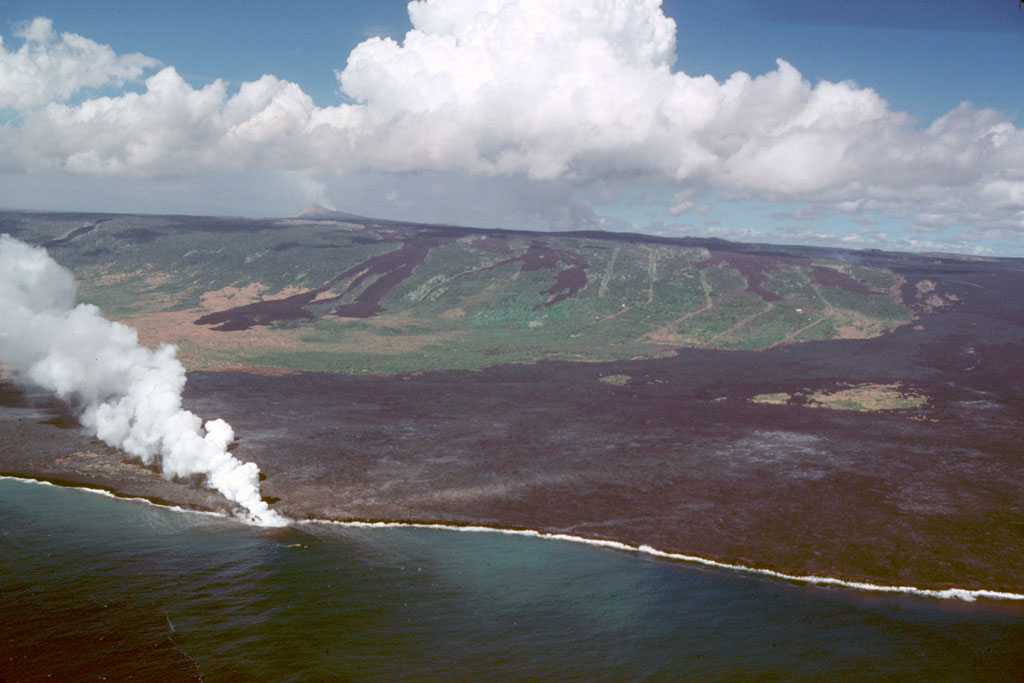
15 (E-8). Close-up of Pu‘u ‘O‘o lava fountain, episode 8 (photo by J.D. Griggs, 9/6/83, JG2895) (picture #015).

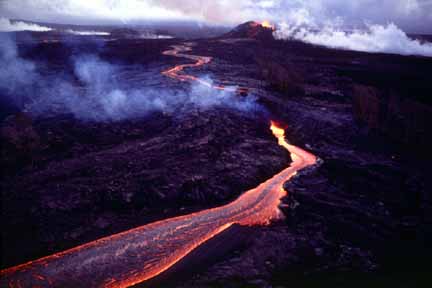
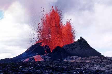
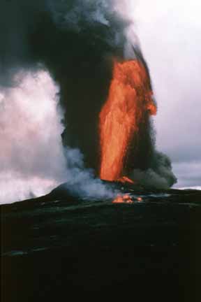
16 (E-8). Pu‘u ‘O‘o fountain approximately 100 m high during episode 8. Dark clots of spatter land near the base of the fountain, contributing to the growth of the cone. Less dense cinder, visible in upper right, is carried downwind of the cone (photo by J.D. Griggs, 9/6/83, JG2939) (picture #016).
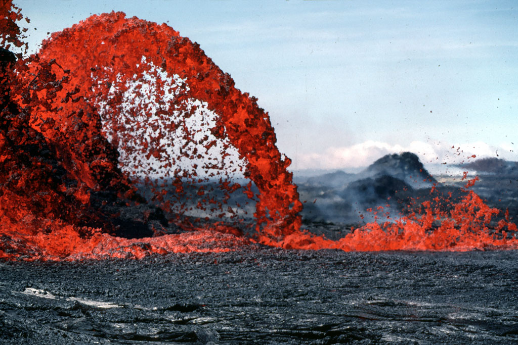
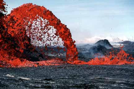
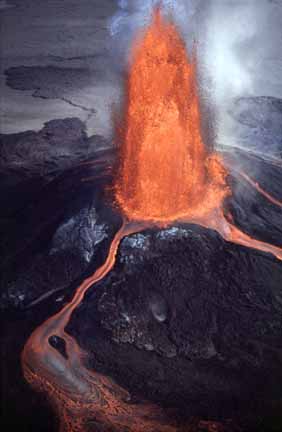
17 (E-8). Jetting fountains, fluctuating in height from tens of meters to 200 m, playing in Pu‘u ‘O‘o crater (episode 10). These fountains varied greatly in height and trajectory and occasionally alternated with a single sustained high fountain (photo by J.D. Griggs, 10/5/83, JG3144) (picture #017).
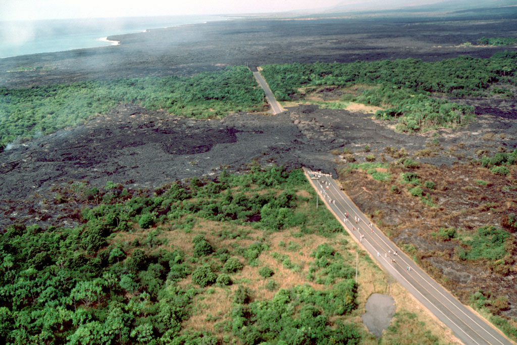
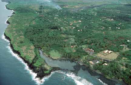
18 (E-8). High (over 200 m) fountain from Pu‘u ‘O‘o in early morning light. Fountains feed ‘a‘a flows to northeast. The characteristic rough, blocky surface of a cooled ‘a‘a flow is visible at the margins of the flow. The river of lava inside the channel travels at a much greater speed than the front of the flow advances (photo by R.W. Decker, 10/5/83, RD108333) (picture #018).
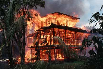
19 (E-13). Dome fountain, 5 m high, in Pu‘u ‘O‘o crater (viewed from north rim), feeds lava flowing over spillway during episode 13 (photo by E.W. Wolfe, 1/20/84, EW18409) (picture #019).
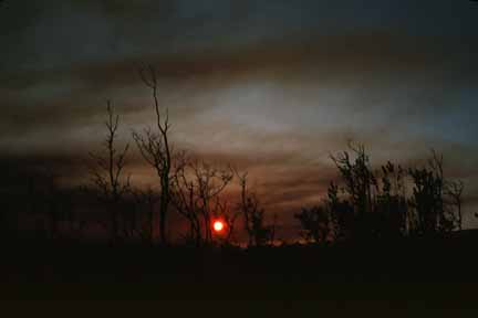
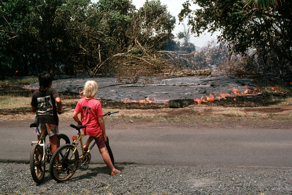
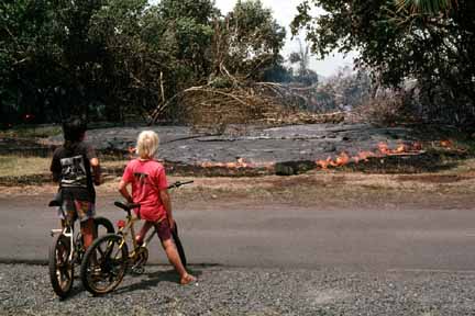
20 (E-13). Sunset seen through the fume from Pu‘u ‘O‘o; view is from Pauahi Crater (photo by R.W. Decker, 1/21/84, RD18430) (picture #020).
21 (E-14). Aerial view of Pu‘u ‘O‘o fountain, approximately 100 m high. Flow from breached northeast rim feeds bifurcating channels (photo by J.D. Griggs, 1/31/84, JG4036) (picture #021).
22 (E-21). Aerial view from the northeast of Pu‘u ‘O‘o fountain and ‘a‘a flow during episode 21. The broad, fan-shaped front of the flow in the foreground is typical of ‘a‘a flows on low-angle slopes (photo by J.D. Griggs, 6/30/84, JG4472) (picture #022).
23 (E-23). Aerial view of Pu‘u ‘O‘o fountain from the north during episode 23. Theodolite measurements of high fountains, which played throughout the day, ranged from 150 to 305 m (photo by J.D. Griggs, 7/28/84, JG4605) (picture #023).
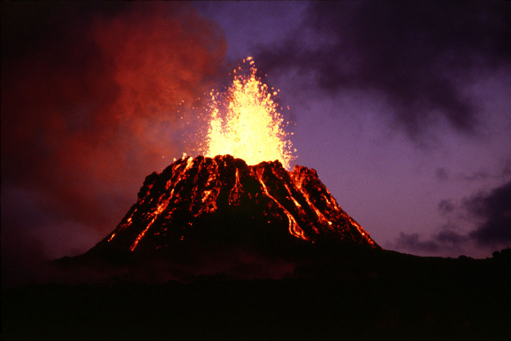
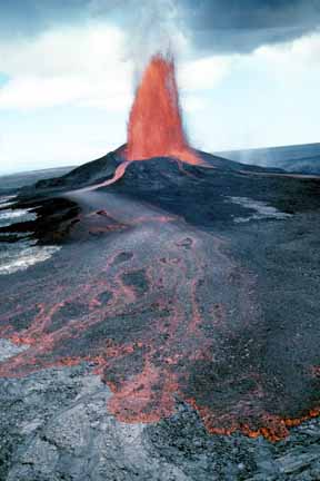
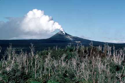
24 (E-25). Pu‘u ‘O‘o fountain, approximately 450 m high, produces clouds of black cinder that are carried downwind (southwest) of the vent. Low fountains play from fissure at base of cone. View is from northeast, at Pu‘u Halulu. Pu‘u ‘O‘o gained 12 m in height during episode 25. By the end of October 1984, Pu‘u ‘O‘o’s height was 155 m above the pre-1983 surface (photo by C.C. Heliker, 9/19/84, CH98435) (picture #024).
25 (pre-E-26). Drainback of lava into Pu‘u ‘O‘o conduit; Mauna Loa, to the northwest, is in the background. The low-level activity took place the day before episode 26 began. A 42-day repose period, the longest since December 1983, preceded episode 26, the briefest (5 hours long) of the episodes of 1983–1984 (photo by G.E. Ulrich, 11/1/84, GU118420) (picture #025).
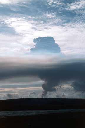
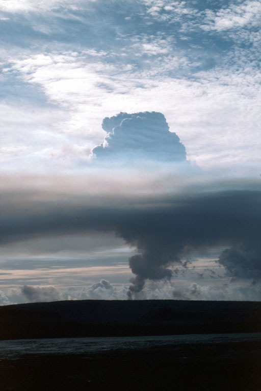
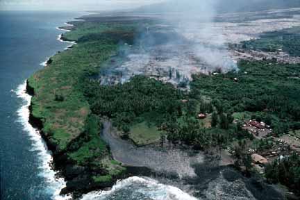
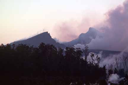
26 (E-32). Pu‘u ‘O‘o plume with inversion layer, viewed from Kilauea’s summit during episode 32. The warm air has not dispersed due to the absence of tradewinds. Volcanic fume consists primarily of water vapor, carbon dioxide, and sulfur dioxide (photo by J.D. Griggs, 4/22/85, JG5351) (picture #026).

27 (E-32). Aerial view, from the east, of waning fountain from Pu‘u ‘O‘o at end of episode 32. Pu‘u ‘O‘o rose 209 m above the pre-1983 surface (928 m above sea level) (photo by J.D. Griggs, 4/22/85, JG5363) (picture #027).
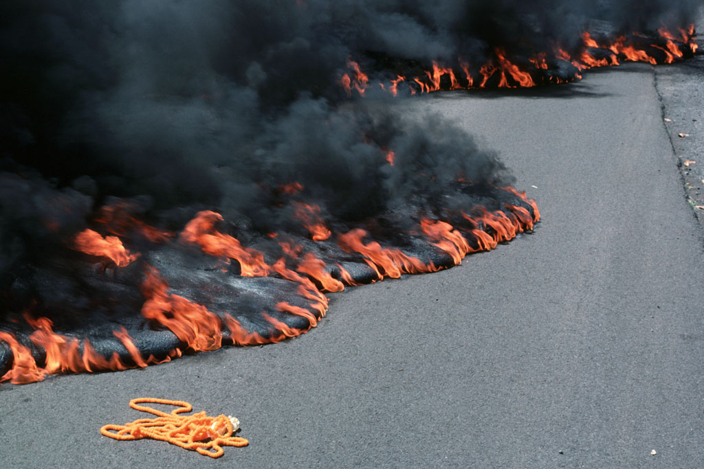
28 (E-35a). Spattering (less than 5 m high) from episode 35a fissure near the west side of Pu‘u ‘O‘o. About 3.5 hours after the fountains of episode 35 died on July 26, ground cracks at the base of the cone propagated uprift, accompanied by booming noises. At 0414 H.s.t. on July 27, the new fissures, which extended 2.5 km uprift, began to erupt along the 1-km stretch closest to Pu‘u ‘O‘o. This activity persisted for 16 days (photo by J.D. Griggs, 7/27/85, JG5600) (picture #028).
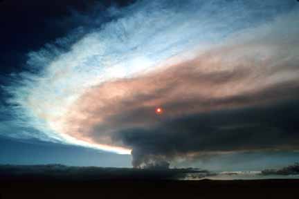
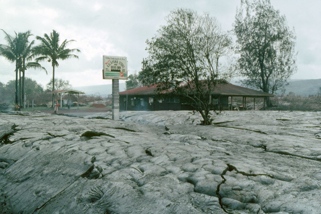
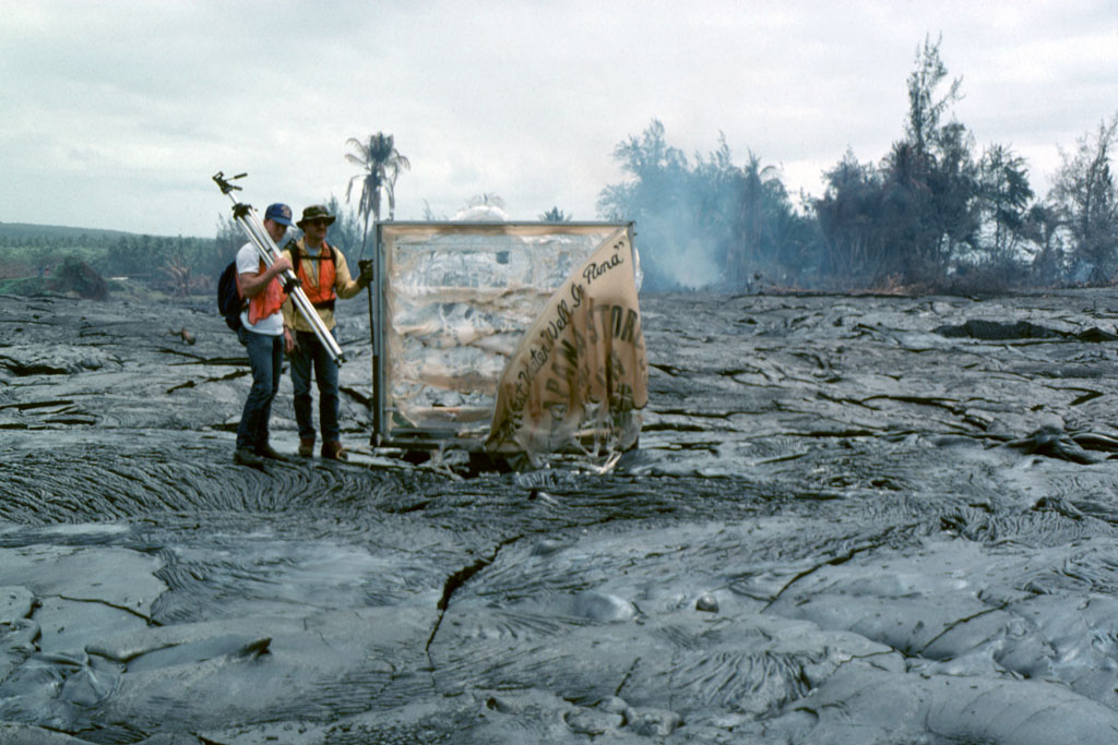
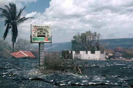
29 (E-38). Sun seen through fume cloud from Pu‘u ‘O‘o, viewed from Uwekahuna overlook at the summit of Kilauea. Fountain heights at Pu‘u ‘O‘o reached a maximum of 295 m around the time this photo was taken during episode 38 (photo by J.D. Griggs, 10/21/85, JG5935) (picture #029).
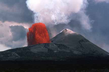
30 (E-39). Pu‘u ‘O‘o fountain and flow at sunset; view, to the southwest, is from Pu‘u Halulu during episode 39 (photo by G.E. Ulrich, 11/13/85, GU118533) (picture #030).

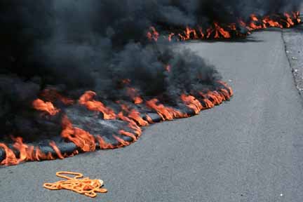
31 (E-46). Jetting fountain and eruption plume, viewed from north side of Pu‘u ‘O‘o during episode 46 (photo by J.D. Griggs, 6/2/86, JG7348) (picture #031).
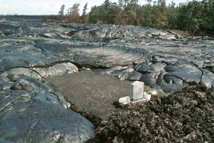
32 (E-46). Round-topped fountain, viewed from north side of Pu‘u ‘O‘o. The cone grew 2 m during episode 46 to its maximum height of 257 m above the pre-1983 surface (photo by J.D. Griggs, 6/2/86, JG7356) (picture #032).
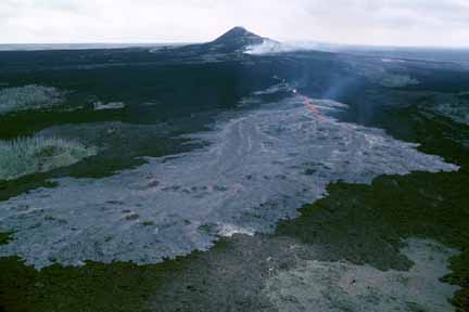
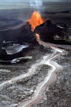
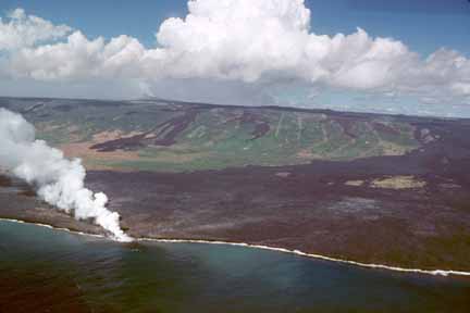
33 (E-48). Aerial view, from the northeast, of pahoehoe flow from the fissure eruption at the site of the Kupaianaha vent. New flows are overriding dark ‘a‘a flows from Pu‘u ‘O‘o, 3 km uprift (in background). The Pu‘u ‘O‘o conduit failed on July 18, triggering fissure eruptions both up- and downrift of the cone. On July 20 (beginning of episode 48), the fissure at this site began to erupt, initiating 5.5 years of near-continuous effusion from the Kupaianaha vent. The high-fountaining episodes of Pu‘u ‘O‘o were over (photo by J.D. Griggs, 7/20/86, JG7632) (picture #033).

34 (E-48). Aerial view of flow from Kupaianaha that demolished a residence near an orchid farm at Kapa‘ahu. Farmers continue to work on what is left of the farm. Flows from Kupaianaha moved through the village of Kapa‘ahu, cut off the coastal highway, and reached the sea in late November 1986 (photo by J.D. Griggs, 12/16/86, JG8502) (picture #034).
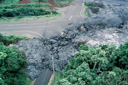
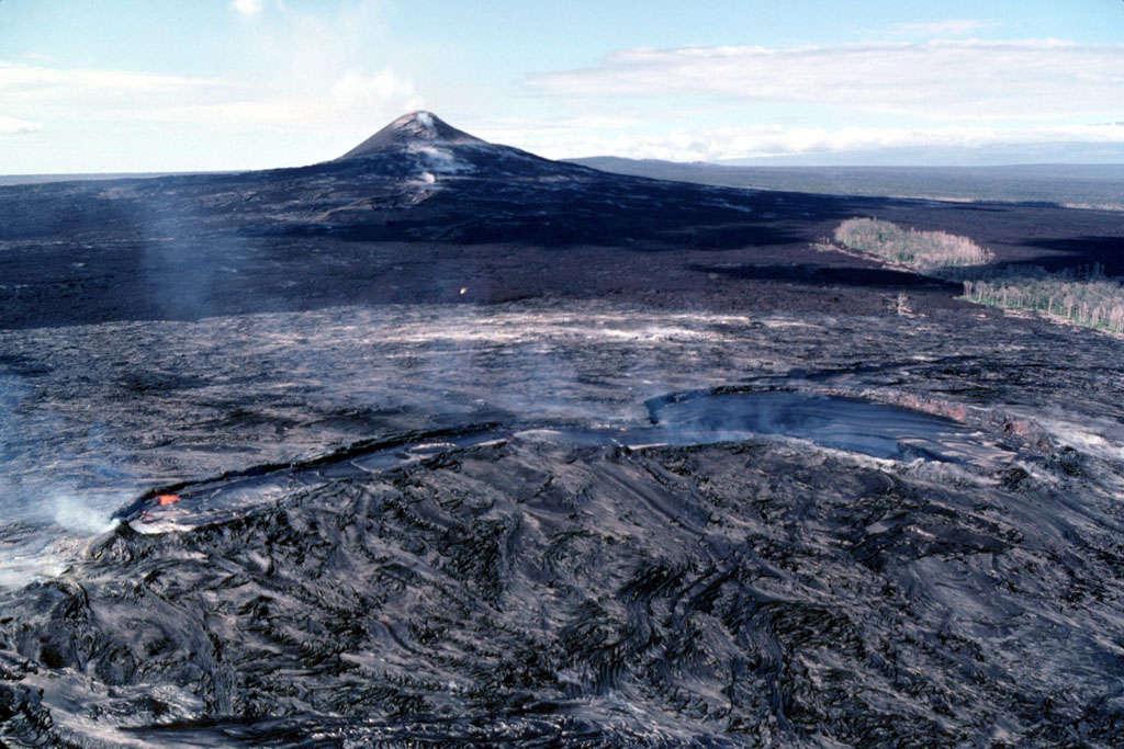
35 (E-48). Aerial view to southeast of tube-fed pahoehoe flow blocking Highway 130 at the entrance to Kalapana Gardens subdivision on Lokelani Street. The flow demolished 14 homes on the northwestern edge of Kalapana in a single day, then stagnated when the tube became blocked near the vent (photo by J.D. Griggs, 12/19/86, JG8610) (picture #035).
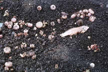
36 (E-48). Aerial view of thin pahoehoe flow advancing through mango trees toward a house in Kalapana Gardens subdivision (photo by J.D. Griggs, 12/19/86, JG12367) (picture #036).
37 (E-48). Aerial view of flow (marked by smoke from burning vegetation) moving into Kalapana Gardens subdivision. Pu‘u ‘O‘o is visible on skyline at center. In the foreground are the Mauna Kea Congregational Church (right of center) and fishponds (lower left) bounded by the Hakuma horst, the uplifted, elongate block at lower left. View is to the northwest (photo by J.D. Griggs, 12/19/86, JG8632) (picture #037).
38 (E-48). Aerial view from the northeast, looking across the Kupaianaha lava pond to Pu‘u ‘O‘o. The lava pond is covered by a thin, mobile crust. The pond is at the top of a broad, low shield 1 km in diameter and about 56 m high. Frequent overflows from the pond in its first year built the shield (photo by J.D. Griggs, 1/13/87, JG8728) (picture #038).
39 (E-48). Aerial view of Kupaianaha lava pond. A vent beneath the broad area to the left supplies lava to the pond, which then flows down the long neck to the right. A lava tube at the end of the neck carries lava downslope. The entrance to the lava tube is visible at the end of the neck (photo by J.D. Griggs, 2/2/87, JG8948) (picture #039).
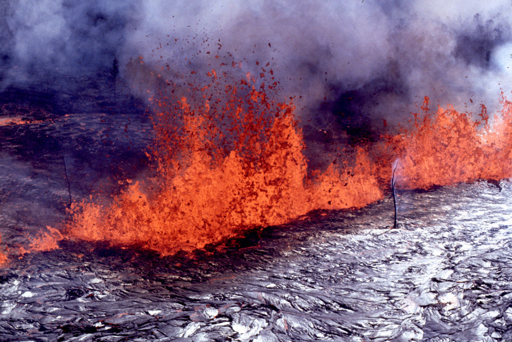
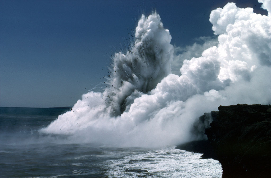
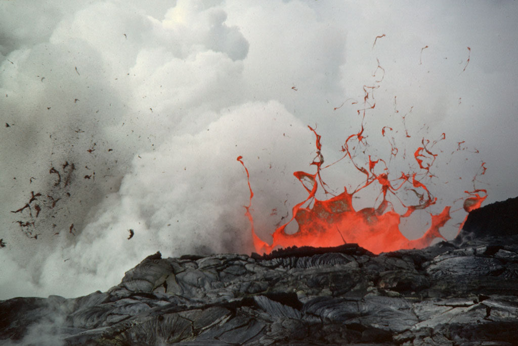
40 (E-48). Pu‘u ‘O‘o fumes in the background, with ‘ohi‘a trees and tree ferns in foreground. In the middle distance is Pu‘u Halulu. View is uprift from Kalalua, a prehistoric cone (photo by J.D. Griggs, 3/11/87, JG9139) (picture #040).

41 (E-48). Queens Bath, a fresh-water-filled graben that was a popular bathing spot in Kapa‘ahu, before being filled by lava from the Kupaianaha vent (photo by J.D. Griggs, 3/31/87, JG9319) (picture #041).
42 (E-48). Bystanders watch steam rising from Queens Bath as lava flow enters the water. Lava overran Highway 130 at 0748 H.s.t. on the same morning at the western margin of the Kapa‘ahu flow. By the end of the day, Punalu‘u heiau was overrun, and Queens Bath was filled with lava (photo by J.D. Griggs, 3/31/87, JG9470) (picture #042).
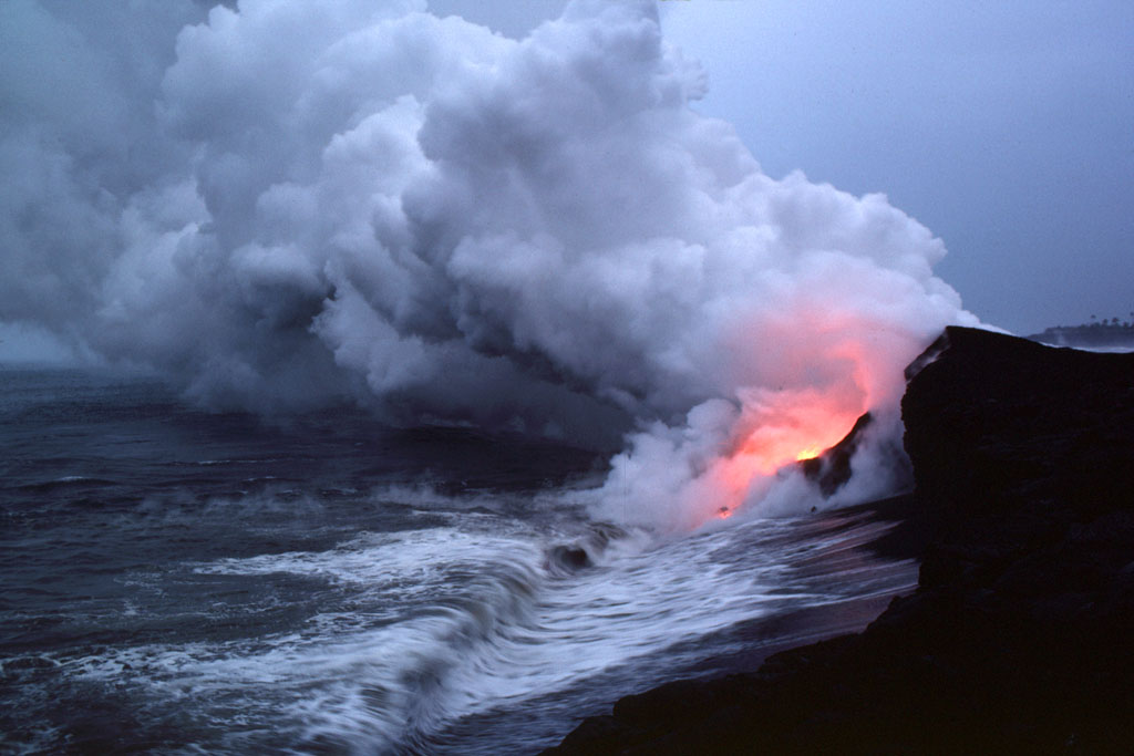
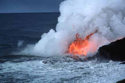
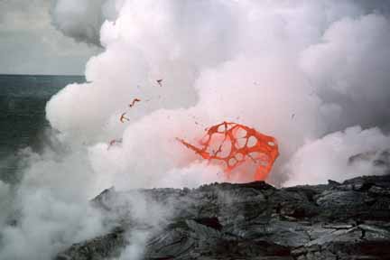
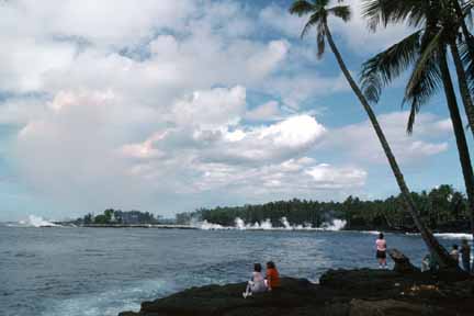
43 (E-48). Billowing steam plume marks the spot where tube-fed lava from Kupaianaha enters the ocean east of Kupapa‘u Point. The plum contains a mixture of hydrochloric acid and concentrated saltwater that is created when lava reacts with seawater. Steam explosions (also called littoral explosions because they occur at the shoreline or littoral zone) spray fragments of lava into the air (photo by J.D. Griggs, 2/3/88, JG10760) (picture #043).
44 (E-48). Glow of lava is reflected in steam plume at water’s edge east of Kupapa‘u Point. A littoral cone formed by spatter from steam explosions sits on top of the sea cliff to the right (photo by T.J. Takahashi, 2/10/88, TT028807) (picture #044).
45 (E-48). Littoral explosion east of Kupapa‘u Point produces thin sheets of spatter known as “limu o Pele” (Pele’s seaweed) (photo by T.J. Takahashi, 2/10/88, TT028838) (picture #045).
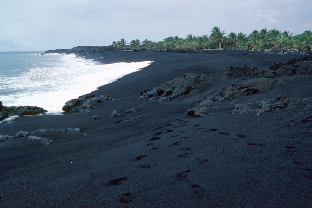
46 (E-48). New black sand beach at Kamoamoa. Lava is fragmented into sand-sized pieces by steam explosions as it enters the ocean. Currents carry the sand until it reaches a protected bay where the sand accumulates, forming a new black sand beach (photo by J.D. Griggs, 3/3/88, JG11546) (picture #046).
47 (E-48). Lava drapery and bench east of Kupapa‘u Point. The drapery was formed when lava flowed over a sea cliff onto the new land forming at its base. New land forms as lava deltas build seaward over steep submarine slopes of spatter, black sand, and pillow lava. These slopes are unstable and prone to slumping, which removes support for the active, leading edge of the lava delta, or “bench.” Benches and deltas can collapse unexpectedly (photo by J.D. Griggs, 4/13/88, JG11606) (picture #047).
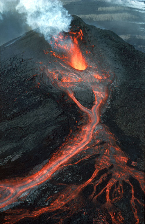
48 (E-48). A thin-walled lava bubble expands and bursts. These “bubble bursts” occur when seawater infiltrates the lava tube system near the shore (photo by J.D. Griggs, 10/5/88, JG12367) (picture #048).
49 (E-48). Lava bubble bursts near shoreline where lava enters the ocean. Such bubble bursts produce translucent sheets of spatter, or “limu o Pele” (photo by J.D. Griggs, 10/5/88, JG12364) (picture #049).
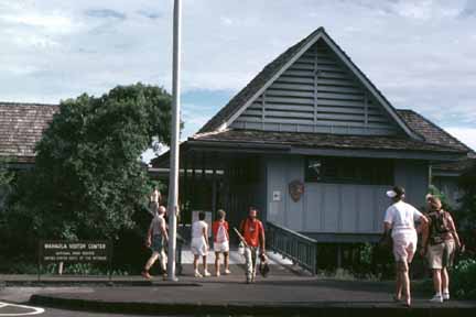
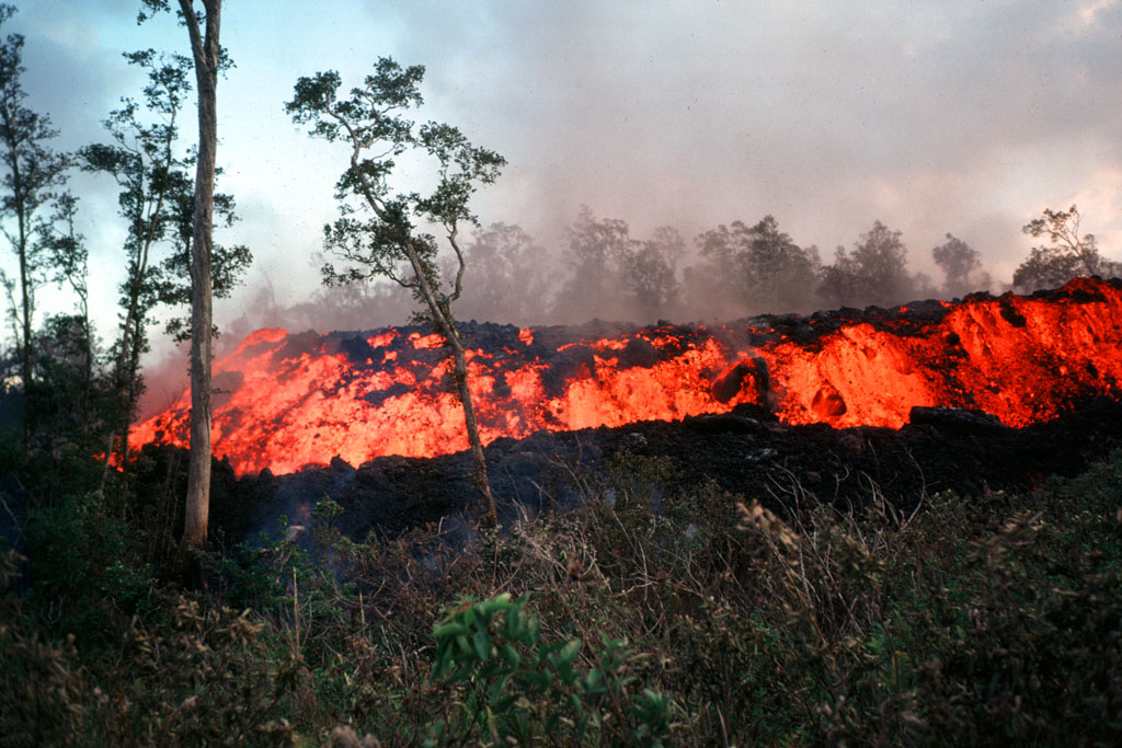
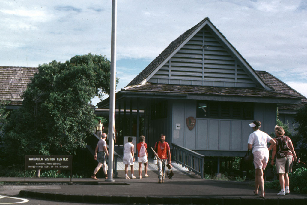
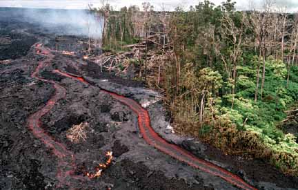
50 (E-48). Waha‘ula Visitor Center before being destroyed by lava flows from Kupaianaha. Groundbreaking for the visitor center in 1966, coincided with the 50th anniversary of the founding of Hawai‘i Volcanoes National Park on August 1, 1916 (photo by T.J. Takahashi, 2/10 /87, TT28711) (picture #050).

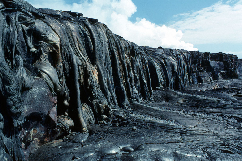
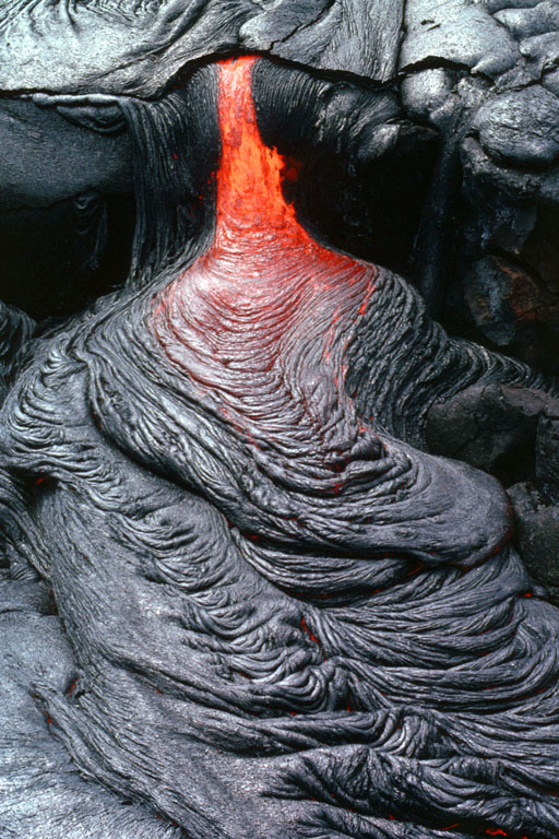
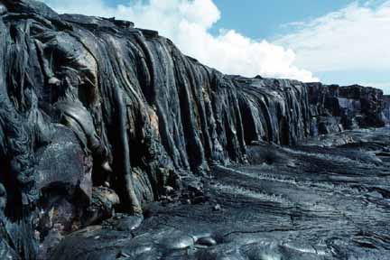
51 (E-48). Lava oozes from within an already crusted flow and forms ropy pahoehoe near Waha‘ula Visitor Center (photo by J.D. Griggs, 6/15/89, JG12539) (picture #051).

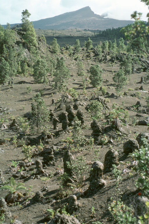
52 (E-48). Lava flow ignites Waha‘ula Visitor Center. The flow moved under the structure despite the Park Service crews’ and volunteers’ efforts to cool it and stop its advance (photo by J.D. Griggs, 6/22/89, JG12788) (picture #052).
53 (E-48). Aerial view of remains of Waha‘ula Visitor Center, with heiau (temple site) still intact in foreground. The Waha‘ula heiau was said to have been built in the eleventh century by the high priest Pa‘ao (photo by J.D. Griggs, 6/28/89, JG13089) (picture #053).
54 (E-48). Steel structural members are all that remain of Waha‘ula Visitor Center after it was destroyed by fire from lava that flowed under the structure and ignited it (photo by J.D. Griggs, 10/12/89, JG13336) (picture #054).

55 (E-48). Lava pours from tube into sea at Poupou west of Kupapa‘u Point and east of the Waha‘ula heiau. The single tube feeding the entry was exposed when the sea cliff beneath the Poupou littoral cone calved off. The lava stream was referred to as a “fire hose” (photo by J.D. Griggs, 11/27/89, JG13424) (picture #055).
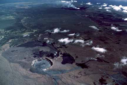
56 (E-48). Aerial view from the eastern coast of Kilauea, looking across Hawaiian Paradise Park subdivision toward Pu‘u ‘O‘o and Kupaianaha (where plume rises) on the horizon (photo by J.D. Griggs, 12/27/89, JG13581) (picture #056).
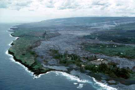
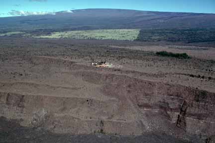
57 (E-48). Aerial view of ocean entry at Poupou and the Kupaianaha flow field. Pu‘u ‘O‘o fumes on the horizon; streets of Royal Gardens subdivision lie on the slopes of Pulama pali above the coastal plain (photo by J.D. Griggs, 12/27/89, JG13655) (picture #057).
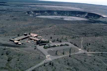
58 (E-48). Aerial view of pahoehoe from Kupaianaha overriding earlier channeled ‘a‘a flows, flowing down Pulama pali through ‘ohi‘a forest on its way to the sea (photo by J.D. Griggs, 2/15/90, JG13956) (picture #058).

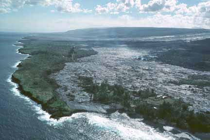
59 (E-48). Aerial view of the “Quarry” flow that crossed Highway 130 west of Kalapana. This flow entered the sea on February 20, 1990 (photo by J.D. Griggs, 2/21/90, JG14246) (picture #059).
60 (E-48). Aerial view of lava encroaching on Kalapana community. Hakuma horst, a raised fault block, is on the left. To the right of the point are fishponds, and to their right, Walter’s Kalapana Store and Drive Inn. In the large trapezoidal plot are Mauna Kea Congregational Church and hall. The white structure across the street from the Congregational Church is St. Mary’s Star of the Sea Catholic Church (photo by J.D. Griggs, 4/3/90, JG14496; see also JG15634 (5/2/90), JG16102 (5/16/90), JG16454 (5/31/90), and JG16718 (6/3/90) (picture #060).
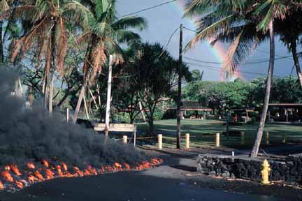
61 (E-48). A three-story house in Kalapana Gardens is ignited by a lava flow, which entered the subdivision on April 17, 1990. By the 24th, more than a dozen houses were destroyed. The total number of homes destroyed by the eruption was 121 by the end of 1990 (photo by J.D. Griggs, 4/22/90, JG14665) (picture #061).
62 (E-48). Children in Kalapana Gardens watch lava moving into their neighborhood. Some of the people whose land was covered by lava were tenth generation residents of Kalapana (photo by J.D. Griggs, 4/22/90, JG14710) (picture #062).
63 (E-48). A lei is offered to appease Pele, goddess of the volcano (photo by J.D. Griggs, 4/22/90, JG14805) (picture #063).
64 (E-48). Aerial view of lava advancing through Kalapana Gardens. The edge of the flow follows the inland contours of Hakuma horst, the fault block to the left (photo by J.D. Griggs, 5/2/90, JG15634) (picture #064).
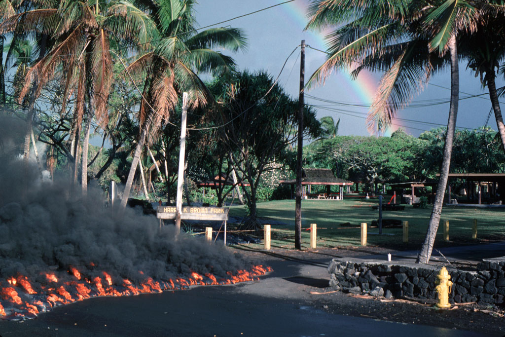
65 (E-48). Lava enters Harry K. Brown Park, originally called “Wai‘akolea Park.” It was renamed “Harry Ka‘ina Brown Memorial Park” in 1953 after Brown, a county auditor, whose ancestral home was in Kalapana. By the end of May 1990, 35 more homes were destroyed; a total of 157 homes had been destroyed since 1983 (photo by D. Weisel, 5/2/90, 59017) (picture #065).

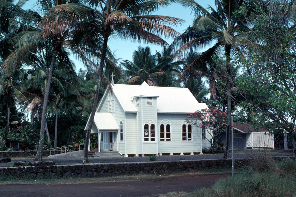
66 (E-48). St. Mary’s Star of the Sea Catholic Church in its original setting in Kalapana. The “Painted Church” was completed by April 19, 1931 (photo by J.D. Griggs, 4/22/90, JG14853) (picture #066).

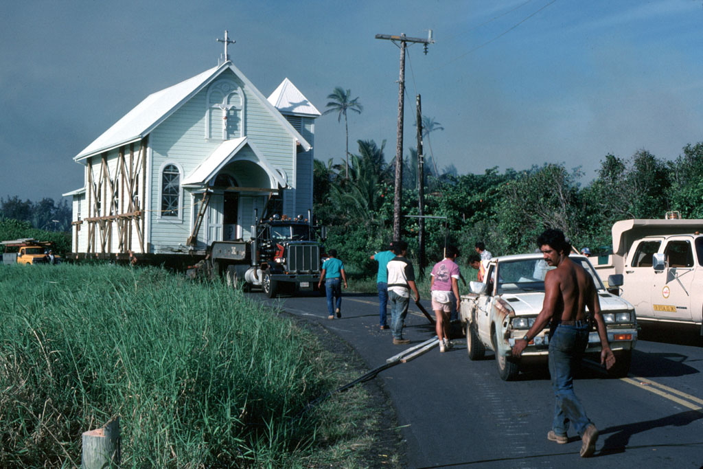
67 (E-48). The Painted Church is finally moved to a safe location at dawn (photo by D. Weisel, 5/4/90, DW59004) (picture #067).
68 (E-48). Aerial view of Kalapana community inundated by tube-fed lava flows (photo by J.D. Griggs, 5/16/90, JG16102) (picture #068).
69 (E-48). Aerial view of flow field in Kalapana. The Mauna Kea Congregational Church (lower right) burned down on May 7 (photo by J.D. Griggs, 5/31/90, JG16454) (picture #069).
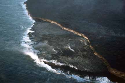
70 (E-48). Aerial view of lava flow entering the ocean at Kalapana (photo by J.D. Griggs, 6/3/90, JG16718) (picture #070).
71 (E-48). Lava surrounds sign at Walter Yamaguchi’s Kalapana Store and Drive Inn, “the oldest water well in Puna.” The store burned down on June 6, the 161st structure overrun by lava (photo by J.D. Griggs, 6/3/90, JG16763; see also JG16888, 6/8/90, and JG17085, 6/13/90) (picture #071).
72 (E-48). Lava rises around Walter’s Drive Inn sign. Concrete walls of the store and roof of the post office are in the background (photo by J.D. Griggs, 6/6/90, JG16888) (picture #072).
73 (E-48). Lava rises to the base of the sign at Walter’s Store and Drive Inn. The sign, with its eight-inch high concrete blocks, was one of the means used to measure inflation of the lava flow (photo by J.D. Griggs, 6/13/90, JG17085) (picture #073).
74 (E-48). Lava surrounds family grave sites in Kalapana (photo by J.D. Griggs, 6/13/90, JG17225) (picture #074).
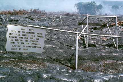
75 (E-48). “Court rules” superseded by lava at the remains of Harry K. Brown Park, Kalapana (photo by J.D. Griggs, 6/30/90, JG18003) (picture #075).
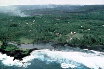
76 (E-48). Lava enters Kaimu Bay, site of renowned black sand beach and coconut grove northeast of Kalapana village (photo by J.D. Griggs, 8/2/90, JG18072) (picture #076).
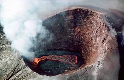
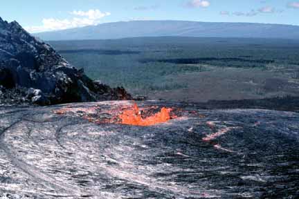
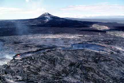
77 (E-48). Aerial view of lava lake in Pu‘u ‘O‘o crater. The crater is about 250 m in diameter (photo by J.D. Griggs, 8/30/90 JG18426) (picture #077).
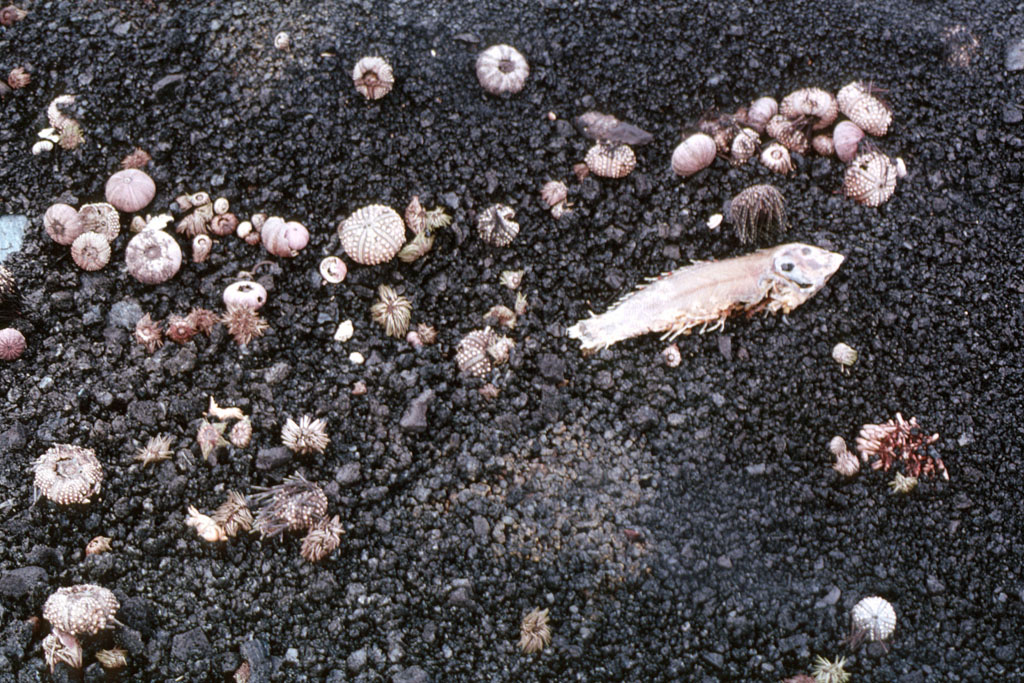
78 (E-48). Marine life washed ashore after being killed by hot, sediment-filled water where lava entered the ocean in Kaimu Bay. Seabirds and other animals came to feast on the remains each day (photo by J.D. Griggs, 10/11/90, JG18928) (picture #078).
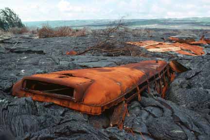
79 (E-48). Bus imbedded in lava with remains of a roof in the background at Kalapana. By this time, an entire community lay buried beneath 15–25 m of lava (photo by J.D. Griggs, 12/4/90, JG19238) (picture #079).
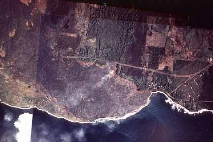
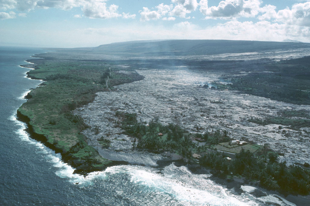
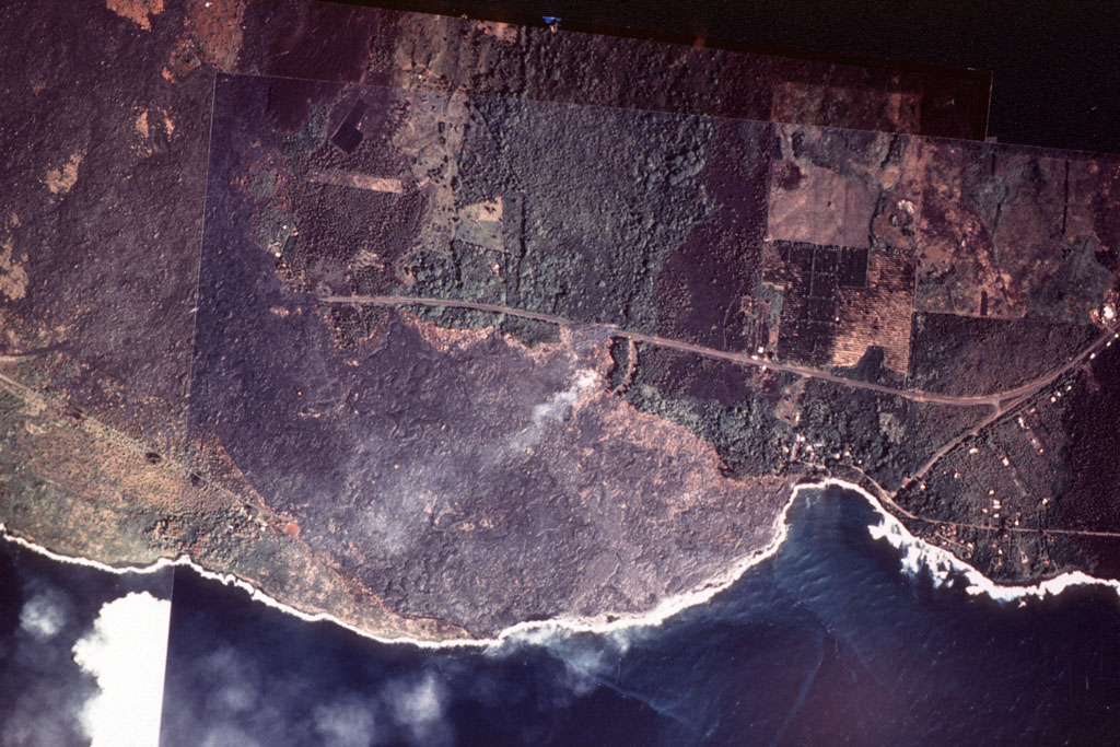
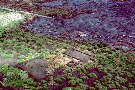
80 (E-48). Vertical aerial-photo mosaic of Kalapana and Kaimu Bay before being filled with lava (see nos. 76 and 81). The flow, advancing eastward, had inundated most of Kalapana before reaching Kaimu Bay (photo by D. Weisel, 8/20/90, DW120A7 and DW120A11) (picture #080).
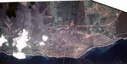
81 (E-48). Vertical aerial-photo mosaic of Kalapana and Kaimu Bay after the bay was filled with lava. The lava extended the shoreline 500 m beyond its original location (photo by D. Weisel, 12/7/90, DW120I15 and DW120I16) (picture #081).
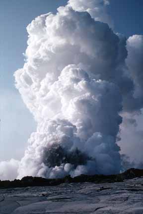
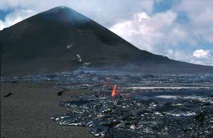
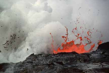
82 (E-52). Littoral explosion at Kamoamoa produces black cloud of spatter at base of billowing white steam plume during episode 52 (photo by L.P. Keszthelyi, 2/5/93, LK020593.11)
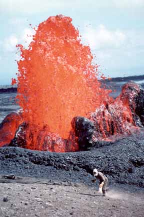
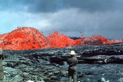
83 (E-53). Geologist collects spatter samples while fountains play southwest of the episode 53 vent at the base of Pu‘u ‘O‘o. The vent began to erupt on February 20 (beginning of episode 53), producing 1–4 m-high fountains that increased in height to 15 m by the 21st (photo by C.C. Heliker, 2/21/93, CH022193.31) (picture #083).
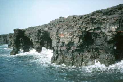
84. Holei sea arches, approximately 30 m high. The arches, formed by constant wave action, were eroded from flows erupted more than 500 years ago from Kane nui o Hamo, a vent in the middle east rift zone (photo by J. Kauahikaua, 3/4/95, JK030495.18) (picture #084).
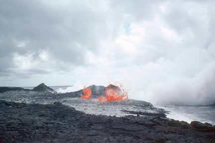
85 (E-53). Lava bubbles burst at the shoreline at Kamoamoa. These bubble bursts occur when seawater infiltrates the lava tube system near the shore. Note two littoral cones, formed by explosion debris, in background (photo by T.N. Mattox, 3/9/94, TM030994.24) (picture #085).
86 (E-53). Skylight in the roof of a lava tube inland of Kamoamoa. Littoral cone and steam plume in the background mark the point where lava enters the ocean (photo by J. Kauahikaua, 3/10/94, JK031094.03) (picture #086).
87 (E-53). Broken lava bubbles in glassy surface of solidified lava from Highcastle flow on the coastal plain (photo by C.C. Heliker, 4/14/95, CH01495.28) (picture #087).
88 (E-53). Incandescent crack in roof of lava tube in the Highcastle flow on the coastal plain (photo by L.P. Keszthelyi, 4/27/95, LK042795.4) (picture #088).

89 (E-53). Littoral explosion at Kamokuna hurls spatter approximately 50 m high during episode 53. Five new littoral cones formed in January. Bench collapses over a 6-hour period on January 30, 1996, resulted in explosions that threw blocks nearly 1 m in diameter up to 250 m inland (photo by C.R. Thornber, 1/28/96, CT012896.10) (picture #089).
90 (E-53). Dome fountains, the largest of which was 7.6 m high, formed over the skylight of a lava tube during an eruptive surge at Pu‘u ‘O‘o. The surge fed a channelized flow down the steep slope of Pulama pali (photo by C.R. Thornber, 2/1/96, CT020196.27) (picture #090).

91 (E-53). Pahoehoe flow draining into skylight of lava tube on upper flow field (photo by C.C. Heliker, 2/2/96, CH020296.16) (picture #091).
92 (E-53). Aerial view of channelized ‘a‘a flow from episode-51 vent advancing down steep slope of Pulama pali. Terminus of flow burns rainforest (photo by C.C. Heliker, 6/4/96, CH060496.22) (picture #092).
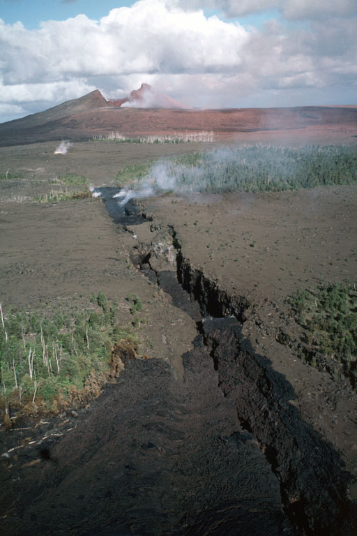
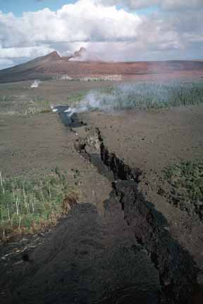
93 (E-54). Aerial view of “west gap” in the Pu‘u ‘O‘o cone that formed on the night of January 29, 1997. The lava pond in the Pu‘u ‘O‘o crater drained, the crater floor collapsed, and the west flank of the cone caved in, creating a gap 150–200 m wide. The collapse resulted in a crater 210 m deep and produced a spectacular blanket of red rock dust (photo by C.R. Thornber, 1/30/97, CT0-13097.3) (picture #093).

94. Lava trees uprift of Pu‘u ‘O‘o. The ground is covered by cinder from the high-fountaining episodes of Pu‘u ‘O‘o from 1983 to 1986 (photo by C.C. Heliker, 1/30/97, CH013097.13) (picture #094).
95 (E-53). Aerial view of Lae‘apuki lava delta, which extends 275 m beyond the earlier shoreline defined by the sea cliff 15–18 m above the delta (photo by C.C. Heliker, 1/30/97, CH013097.32) (picture #095).
96 (E-54). Dark lava from episode 54 eruptive fissures flowed into old cracks uprift of Pu‘u ‘O‘o. The cone is coated with red rock dust from the collapse of the crater and west flank. Five closely spaced fissures in, and downrift of, Napau Crater were active during the 22-hour-long episode 54 (photo by C.C. Heliker, 1/31//97, CH013197.21) (picture #096).
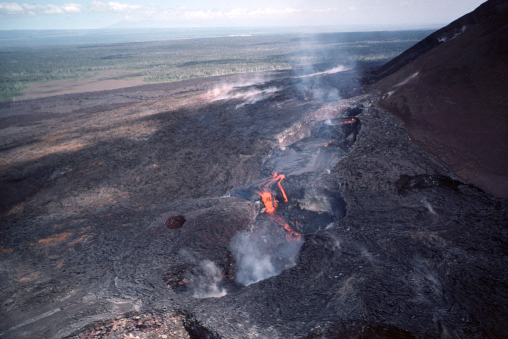
97 (E-55). Aerial view of lava from flank vents on the west slope of Pu‘u ‘O‘o early in episode 55. Lava is ponding in a series of collapse pits (photo by C.R. Thornber, 4/1/97, CT040197.26) (picture #097).
98. Aerial view looking across summit caldera of Kilauea toward Pu‘u ‘O‘o on the east rift zone. Kilauea caldera, containing Halemaumau Crater, is in the lower left, with Hawaiian Volcano Observatory (HVO) on the caldera’s rim to the left of Halemaumau. Pu‘u ‘O‘o fumes in the distance on the east rift zone (photo by J.D. Griggs, 1/10/85, JG18537) (picture #098).
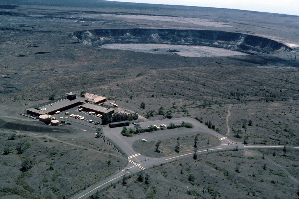
99. Aerial view of Hawaiian Volcano Observatory (HVO) situated on Uwekahuna bluff atop a series of step faults on the northwest rim of Kilauea caldera. Mauna Loa is in the background (photo by J.D. Griggs, 8/22/85, JG88519) (picture #099).
100. Aerial view of HVO. The newest wing (with the observation tower) was built in 1986 and dedicated on the 75th anniversary of HVO on January 18, 1987 (photo by J.D. Griggs, 10/23/86, JG40238) (picture #100).