
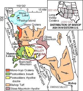
|
Much of the
Long Valley area of eastern California is
covered by rocks formed during volcanic eruptions
in the past 2 million years. A cataclysmic eruption
760,000 years ago formed Long Valley Caldera and ejected
flows of hot glowing ash, which cooled to form the Bishop
Tuff. Wind-blown ash from that ancient eruption
covered most of the Western United States
(inset). This massive eruption was followed by hundreds of smaller eruptions over the next few hundred thousand years. These eruptions of lava flows, domes, and pyroclastic flows were concentrated in the central and western parts of the caldera (green and yellow areas). Mammoth Mountain was built eruptions between about 200,000 and 50,000 years ago. Volcanic activity then moved northward to the Mono Lake area about 35,000 years ago to build the Mono Craters. The most recent eruptions in the area occurred from the Mono and Inyo Craters about 600 years ago, and from Negit Island in Mono Lake about 250 years ago. |