
by Peter N. Schweitzer
U.S. Geological Survey Digital Data Series DDS-10
Contents
- Disclaimer
- Introduction
- Data Set Structure
- System Requirements
- Annotated List of Digital Files
- Programming Notes
- Data Sources
- Technical Contacts
- References
- Appendixes:
- Relationship of Pixel Values to Temperature
- Dates Spanned by Weekly Files
- User's Guide to Included Programs
- List of Trademarks
Other potentially useful documents
Library of Congress Cataloging in Publication Number 93-9075
This publication was prepared by an
agency of the United States Government. Neither the United States
Government, nor any agency thereof, nor any of their employees, makes any
warranty, expressed or implied, or assumes any legal liability or
responsibility for the accuracy, completeness, or usefulness of any
information, apparatus, product, or process disclosed in this report, or
represents that its use would not infringe privately owned rights.
Reference herein to any specific commercial product, process, or service
by trade name, trademark, manufacturer, or otherwise does not necessarily
constitute or imply its endorsement, recommendation, or favoring by the
United States Government or any agency thereof. Any views or opinions of
authors expressed herein do not necessarily state or reflect those of the
United States Government or any agency thereof.
Although all data and software presented in this publication have been used by
the USGS, no warranty, expressed or implied, is made by the USGS as to the
accuracy of the data and related materials or the functioning of the
software. The act of distribution shall not constitute any such warranty,
and no responsibility is assumed by the USGS in the use of these data,
software, or related materials.
Click here to return to the table of contents
The purpose of this data set is to provide paleoclimate researchers with a
tool for estimating the average seasonal variation in sea-surface
temperature (SST) throughout the modern world ocean and for estimating the
modern monthly and weekly sea-surface temperature at any given oceanic
location. It is expected that these data will be compared with
temperature estimates derived from geological proxy measures such as
faunal census analyses and stable isotopic analyses. The results can then
be used to constrain general circulation models of climate change.
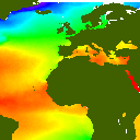
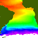
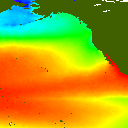
The data contained in this data set are derived from the NOAA Advanced Very
High Resolution Radiometer Multichannel Sea Surface Temperature data (AVHRR
MCSST), which are obtainable from the Distributed Active Archive Center at
the Jet Propulsion Laboratory (JPL) in Pasadena, Calif. The JPL
tapes contain weekly images of SST from October 1981 through December 1990
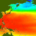
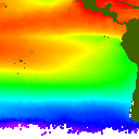
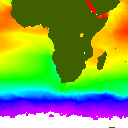
in nine regions of the world ocean: North Atlantic, Eastern North
Atlantic, South Atlantic, Agulhas, Indian, Southeast Pacific, Southwest
Pacific, Northeast Pacific, and Northwest Pacific.
This data set represents the results of calculations carried out on the
NOAA data and also contains the source code of the programs that made
the calculations. The objective was to derive the average sea-surface
temperature of each month and week throughout the whole 10-year series,
meaning, for example, that data from January of each year would be
averaged together. The result is 12 monthly and 52 weekly images for each
of the oceanic regions. Averaging the images in this way tends to reduce
the number of grid cells that lack valid data and to suppress interannual
variability.
As ancillary data, the ETOPO5 global gridded elevation and bathymetry data
(Edwards, 1989) were interpolated to the resolution of the SST data; the
interpolated topographic data are included.
The images are provided in three formats: a modified form of run-length
encoding (MRLE), Graphics Interchange Format (GIF), and Macintosh PICT
format.
Also included in the data set are programs that can retrieve seasonal
temperature profiles at user-specified locations and that can decompress
the data files. These nongraphical SST retrieval programs are provided in
versions for UNIX, MS-DOS, and Macintosh computers. Graphical browse
utilities are included for users of UNIX with the X Window System,
80386-based PC's, and Macintosh computers.
Click here to return to the table of contents
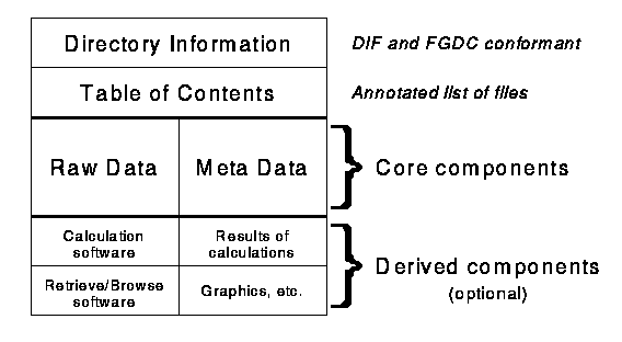
The structure of this data set is illustrated in the diagram below. Files
are organized into three groups: contents information, core components,
and derived components.
- Contents Information
- These files indicate the general character of the data set and are
intended to help potential users decide whether to obtain the full data
set or not. The information is provided in ASCII files and consists of a
description in Directory Interchange Format (DIF) and an annotated list of
files.
- Core Components
- Raw Data
- These files contain the fundamental observations and portable program
source code that is essential for using the raw data. Source code is
provided here for two programs, one to retrieve SST values, given a list
of SST data files and a list of geographic locations, and one to expand
the compressed data files into the same format as the original JPL files.
The SST data files themselves are provided as monthly and weekly averages.
- In addition to the SST data, gridded topographic data are provided at the
same resolution.
- Meta Data
- These files contain information essential for understanding the
observations but not necessary for using them. A text version of this
report is included as metadata, as are the source code files of programs
originally used to produce the data set, a program to convert the
compressed SST image files into a portable format, and a program to
display the relationship between pixel values and temperature.
- Derived Components
- These files describe details or provide capabilities that are not needed
to access or interpret the fundamental data. They may be useful to some
researchers. Graphical programs are provided to users of UNIX with the
X Window System, 80386-based PC's, and for Macintosh users, permitting
them to extract SST profiles and view individual SST images. Executable
versions of all programs and source code for graphical programs are
included here.
Click here to return to the table of contents
This data set is intended for use on MS-DOS, Macintosh, and UNIX computer
systems. Included in the data set are simple programs to extract
numerical values from the data files and more elaborate graphical display
programs, which require more sophisticated hardware to use. Listed below
are the minimum system requirements for each of the supported platforms;
the additional memory and display capabilities required by the graphical
software are noted.
- MS-DOS
- IBM or compatible personal computer
- MS- or PC-DOS version 3.3 or later
- Microsoft MSCDEX version 2.1 or later
- CD-ROM drive with ISO 9660 software driver
- The graphical display software requires the following:
- 80386 or 80486 CPU
- 4 megabytes of RAM configured as extended memory
- Super VGA graphics system with at least 640 x 400 in 256 colors; Video adapters based on the following chips are supported:
- Paradise
- Video 7
- ATI Wondercard, ATI VGA Wonder
- Oak Technologies
- Trident
- Genoa 6400 and 6600
- Tseng Labs ET3000 and ET4000
- Chips and Technologies
- Macintosh
- Macintosh computer
- CD-ROM drive
- The graphical display software requires the following:
- 4 megabytes of RAM
- 256-color display
- UNIX
- ANSI-conformant C language compiler
- CD-ROM drive with ISO 9660 software driver
- The graphical display software requires the following:
- 8 megabytes of RAM
- X Window System version 11, release 3 or later
Click here to return to the table of contents
Text Files
- report.txt
- Description of the structure and contents of the data set.
- magsst.dif
- Data set directory entry in DIF format.
- contents.txt
- Brief annotated list of files.
Program Source Files
UNIX versions of the programs differ significantly from MS-DOS and
Macintosh versions because the latter two systems constrain the use of
memory by applications. As a result, code developed for UNIX is simpler
and may be more easily understood by a reader.
- calibrate.c
- Prints the relationship between SST image values and temperature in degrees Celsius.
- sum.c
- (UNIX) Calculates the average SST for a section of the region specified. Either weekly or monthly averages can be calculated.
- combine.c
- (UNIX) Combines files output by sum.c, producing image files of the same format as the original NOAA files.
- wr_mrle.c
- (UNIX) Compression of image files through modified run-length encoding.
- mrd_mrle.c
- (Macintosh and MS-DOS) Decompresses the images output by wr_mrle, producing a file with the original image format.
- urd_mrle.c
- (UNIX version)
- mrletoppm.c
- (UNIX) Converts a file from modified run-length encoding to a portable pixmap, which can be used with the pbmplus package, a freely available image translation utility.
- m_rtrv.c
- (Macintosh and MS-DOS) Character-based temperature retrieval program. Given a list of input data files and a request file containing locations, this program returns one temperature estimate per data file for each requested location.
- u_rtrv.c
- (UNIX version)
- see.c
- (UNIX) Graphical temperature retrieval program requiring X Windows version 11, release 3 or 4, based on Xlib. Allows interactive viewing of seasonal and geographic temperature data.
- see.icon
- Ancillary to see.c.
- quarter.c
- (UNIX) Reads an SST file in MRLE format and outputs a 256 x 256 pixel version of the same file, both in MRLE format and in portable pixmap format. The MRLE format output file has no header records. These output files are used as input to the Macintosh graphical browse utility.
- weekdate.c
- Prints a table showing the dates covered by weekly files.
- getdepth.c
- (UNIX) Interpolates ETOPO5.IMG to produce depth data at the same resolution as the SST data.
- depthppm.c
- (UNIX) Creates a portable pixmap from the output of getdepth.
Executable Program Files
Files listed below with extension .hqx are binary files that have been
converted to ASCII using BinHex 4.0. This conversion is necessary because
UNIX and MS-DOS file systems have no convenient way to store the resource
fork of a Macintosh file.
- dos_rtrv.exe
- (MS-DOS) Character-based retrieval program.
- mac_rtrv.hqx
- (Macintosh) Character-based retrieval program.
- lookup.hqx
- (Macintosh) Look up SST, a character-based SST retrieval program.
- see.hqx
- (Macintosh) See SST, a graphical SST retrieval program.
- see.exe
- (Extended MS-DOS) Graphical SST retrieval program.
- dos4gw.exe
- DOS-extender that loads and executes see.exe.
Macintosh-Specific Source Code and Data
Because Macintosh files may have resource forks, which cannot be handled
conveniently by MS-DOS and UNIX, archives of Macintosh-specific source
files are made available. These are useful if, for example, your MS-DOS
computer has a CD-ROM drive but your Macintosh does not. You can use the
MS-DOS machine to transfer these archives from the CD-ROM to the Macintosh
via floppy disk or a network and then unpack the archives on the Macintosh.
- look_sea.hqx
- Self-extracting archive of sources for Look up SST.
- see_sea.hqx
- Self-extracting archive of sources for See SST.
- sst_data.hqx
- Self-extracting archive of data for See SST.
MS-DOS-Specific Source Code
The graphical SST retrieval program see.c is provided in source and
executable versions for the extended MS-DOS platform. This program
requires an 80386 or 80486 CPU and a super VGA card capable of displaying
256 colors at a spatial resolution of 640 x 400 or greater. It relies on
the Watcom version of the DOS-extender DOS4G, called DOS4GW, which is
included on the disc.
- see.c
- Main source code module.
- cursor.c
- Routine to draw a cursor on the super VGA screen.
- doskeys.h
- Definitions of keystrokes.
- add1.asm
- Routines for adjusting color cells and reading etopo5.
- bios.asm
- Routines to get information from the BIOS.
- mouse.asm
- Routines to handle low-level interactions with the mouse driver.
- keyboard.asm
- Routines to handle keyboard input.
- lfl9x16.fon
- Font for use in 800 x 600 and 1024 x 768 modes.
Data Files
The data are stored in subdirectories according to the region they portray.
Each file is compressed with modified run-length encoding, as output by the
program wr_mrle, whose source is included.
 na = North Atlantic Ocean
 nae = North Atlantic East, including the Mediterranean Sea
 sa = South Atlantic Ocean
 nep = Northeast Pacific Ocean
 nwp = Northwest Pacific Ocean
 sep = Southeast Pacific Ocean
 swp = Southwest Pacific Ocean
 io = Indian Ocean
 ag = Agulhas region (South Africa)
Monthly files are named as m_mon.reg, where mon is the three-letter
abbreviation for the month, and reg is the two- or three-letter
abbreviation for the region. A list of monthly files is included, called
monthly.reg, with the appropriate region code substituted for reg.
Each monthly directory has subdirectories gif, pict, and weekly. The gif
subdirectory contains files in the Graphics Image Format (GIF) developed by
CompuServe, Inc., and those files are named as m_mon reg.gif, where mon is
the month and reg is the region code. The pict subdirectory contains
files in the Macintosh PICT image format, and those files are named as
m_mon reg.pic, where mon is the month and reg is the region code.
The weekly subdirectory contains weekly average SST images for the
region. The weekly files are named as week00.reg where reg is the region
code and 00 is replaced by the week number, beginning with 00 and ending
with 51.
Each weekly directory has subdirectories gif and pict. The weekly gif
subdirectory contains files in the Graphics Image Format (GIF), and those
files are named as w_00 reg.gif, where reg is the region code and 00 is
replaced with the week number, from 00 to 51. The weekly pict
subdirectory contains files in the Macintosh PICT image format, and those
files are named as w_00 reg.pic, where reg is the region code and 00 is
replaced with the week number, from 00 to 51.
The gridded elevation and bathymetry data are included for each region in
binary files named etopo5.reg and etopo5q.reg, where reg is the
appropriate region abbreviation. Those files named etopo5 are at the full
512 x 512 resolution, while those named etopo5q are quarter-sized images
at half resolution (256 x 256 pixels). The gif and pict subdirectories
contain the same topographic data files in the corresponding image formats.
Note that the elevation and bathymetry data require two bytes per pixel,
and the data files etopo5.* and etopo5q.* are big-endian, meaning they
follow a most-significant-byte-first ordering scheme. For an example of
how these data should be handled on 80x86-based computers, see the file
add1.asm in the directory Derived/dos/dos_see.
Example: This list describes the data files pertaining to the North
Atlantic Ocean. The slash character (/) is used as a path separator
corresponding to the backslash in MS-DOS and the colon in Macintosh.
na/
  m_jan.na,...,m_dec.na         Average monthly SST, MRLE format.
  monthly.na                    List of monthly MRLE files.
  etopo5.na                     Topography (512 x 512).
  etopo5q.na                    Topography (256 x 256).
  gif/
    etopona.gif                 Topography (512 x 512 GIF format).
    etopqna.gif                 Topography (256 x 256 GIF format).
    m_janna.gif,...,m_decna.gif Average monthly SST, GIF format.
  pict/
    etopona.pic                 Topography (512 x 512 PICT format).
    etopqna.pic                 Topography (256 x 256 PICT format).
    m_janna.pic,...,m_decna.pic Average monthly SST, PICT format.
  weekly/
    week00.na,...,week51.na     Average weekly SST, MRLE format.
    weekly.na                   List of weekly MRLE files.
    gif/
      w_00na.gif,...,w_51na.gif Average weekly SST, GIF format.
    pict/
      w_00na.pic,...,w_51na.pic Average weekly SST, PICT format.
Each of the nine regional data directories thus contains 200 files as
follows:
-------------------------------------------------------
Description                        Count    Example
-------------------------------------------------------
SST monthly averages (MRLE)          12     m_jan.na
SST monthly index                     1     monthly.na
SST monthly averages (GIF)           12     m_janna.gif
SST monthly averages (PICT)          12     m_janna.pic
SST weekly averages (MRLE)           52     week00.na
SST weekly index                      1     weekly.na
SST weekly averages (GIF)            52     w_00na.gif
SST weekly averages (PICT)           52     w_00na.pic
Topography 512x512 (raw)              1     etopo5.na
Topography 512x512 (GIF)              1     etopona.gif
Topography 512x512 (PICT)             1     etopona.pic
Topography 256x256 (raw)              1     etopo5q.na
Topography 256x256 (GIF)              1     etopqna.gif
Topography 256x256 (PICT)             1     etopqna.pic
-------------------------------------------------------
Total                               200
Click here to return to the table of contents
This data set was developed using a Data General AViiON 300CD workstation
running the DG/UX version of UNIX. Due to the large amount of memory
required, some of the programs whose source code is included will not run
under MS-DOS and would require substantial customization to be run on a
Macintosh.
The portable programs are the character-based temperature retrieval
program (u_rtrv.c and m_rtrv.c), the calibration printing program
(calibrat.c), and the data file decompression utility (urd_mrle.c and
mrd_mrle.c). Extensions to the C programming language that are peculiar to
the compilers are kept to a minimum; these extensions relate mostly to
pointers (MS-DOS uses segmented pointers) and memory allocation. THINK C
lacks a stricmp library function, so this was conditionally coded in
m_rtrv.c.
The compilers used to build the programs are listed below.
------------------------------------------------------
System          Compiler version and vendor
------------------------------------------------------
MS-DOS          Turbo C 2.01 small memory model
Extended DOS    Watcom C/386 version 9.01, with DOS4GW
Macintosh       THINK C 5.0.4
DG/UX           GNU C 1.96
The nonportable programs consist of see.c, a UNIX application whose user
interface is based on X Windows, Look up SST and See SST, Macintosh
applications that use the Macintosh Toolbox, and the extended-DOS version
of see.c, which uses Microsoft-compatible graphics library functions, as
supplied with the Watcom compiler.
Click here to return to the table of contents
The original NOAA AVHRR MCSST data set can be obtained from
NASA Ocean Data System
MS 300-320
Jet Propulsion Laboratory
4800 Oak Grove Drive
Pasadena, CA 91109
Tel: (818) 354-0906
FAX: (818) 393-6720
The original data come on nine nine-track tapes, 6250 bpi VAX backup format,
each containing 467 weekly SST files. Each file is binary and 257.5 kbytes
in length.
The gridded elevation and bathymetry data were interpolated (using the
program getdepth, whose source getdepth.c is included) from the ETOPO5
data set of Edwards (1989), available from NOAA on CD-ROM. The full data
set citation is described in the NOAA Global Ecosystems Database
documentation manual as follows:
NOAA/NGDC. 1992. Integrated Global Elevation and Bathymetry. Digital
Data. NOAA/NGDC/WDC-A, Boulder, Colorado. Digital raster data on a
5-minute geographic (lat/long) 2160x4320 grid. In: Global Ecosystems
Database Version 1.0: Disc A. Boulder, CO: NOAA National Geophysical Data
Center. 1 independent single-attribute spatial layer on CD-ROM. 18.6 MB.
[First published in 1989.]
Click here to return to the table of contents
The principal technical contact is the author of all programs and
documentation contained in this data set. Questions regarding the
operation of these programs, the contents of the CD-ROM, and the relevant
source code should be directed to
    Peter N. Schweitzer
    MS 955, National Center
    U.S. Geological Survey
    Reston, VA 22092

    Tel: (703) 648-6533
    FAX: (703) 648-6647
    Email: pschweitzer@usgs.gov
Questions pertaining to the processing of the original AVHRR data from
which the NOAA MCSST data tapes were made should be directed to the
technical contacts for the original data:
    Ruby Lassanyi or Elizabeth Smith
    JPL/DAAC MS 300-320
    Jet Propulsion Laboratory
    4800 Oak Grove Drive
    Pasadena, CA 91109

    Tel: (818) 354-0906 or (818) 354-6980
    OMNET: NODS.JPL
Questions pertaining to the original ETOPO5 data should be directed to the
NGDC technical support staff:
    Global Ecosystems Database Project
    National Geophysical Data Center
    325 Broadway E/GC1
    Boulder, CO 80303

    Tel: (303) 497-6125
    FAX: (303) 497-6513
    Email: info@mail.ngdc.noaa.gov
Click here to return to the table of contents
- Edwards, M.H. 1989, Global Gridded Elevation and Bathymetry
(ETOPO5): Digital raster data on a 5-minute geographic (lat/long)
2160x4320 (centroid-registered) grid. Boulder, Colo.: NOAA National
Geophysical Data Center. 9-track tape, 18.6 megabytes.
- McClain, E.P., Pichel, W.G., and Walton, C.C., 1985, Comparative
performance of AVHRR-based multichannel sea surface temperatures: Journal
of Geophysical Research, v. 90, p. 11587-11601.
- Smith, E., 1991, A user's guide to the NOAA Advanced Very High Resolution
Radiometer Multichannel Sea Surface Temperature data set produced by the
University of Miami/Rosenstiel School of Marine and Atmospheric Science:
Distributed by the Distributed Active Archive Center, Jet Propulsion
Laboratory, Pasadena, California. 10 p.
Click here to return to the table of contents
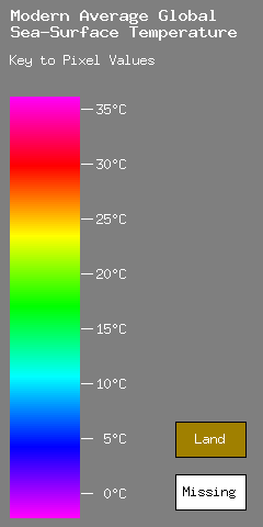
These tables relate pixel values, which are eight-bit unsigned numbers, to
the corresponding sea-surface temperatures in degrees Celsius. The pixel
values are indicated by hexadecimal numbers expressed in the notation
of the C programming language; 0x11 denotes the decimal number 17, 0x0A
represents decimal 10, 0xFF represents decimal 255, and so forth.
In the tables, the column c indicates the most significant hexadecimal
digit of the pixel value, and the row r indicates the least signficant
digit.
      0x0r  0x1r  0x2r  0x3r  0x4r  0x5r  0x6r  0x7r
0xc0  -2.1   1.1   4.3   7.5  10.7  13.9  17.1  20.3
0xc1  -1.9   1.3   4.5   7.7  10.9  14.1  17.3  20.5
0xc2  -1.7   1.5   4.7   7.9  11.1  14.3  17.5  20.7
0xc3  -1.5   1.7   4.9   8.1  11.3  14.5  17.7  20.9
0xc4  -1.3   1.9   5.1   8.3  11.5  14.7  17.9  21.1
0xc5  -1.1   2.1   5.3   8.5  11.7  14.9  18.1  21.3
0xc6  -0.9   2.3   5.5   8.7  11.9  15.1  18.3  21.5
0xc7  -0.7   2.5   5.7   8.9  12.1  15.3  18.5  21.7
0xc8  -0.5   2.7   5.9   9.1  12.3  15.5  18.7  21.9
0xc9  -0.3   2.9   6.1   9.3  12.5  15.7  18.9  22.1
0xcA  -0.1   3.1   6.3   9.5  12.7  15.9  19.1  22.3
0xcB   0.1   3.3   6.5   9.7  12.9  16.1  19.3  22.5
0xcC   0.3   3.5   6.7   9.9  13.1  16.3  19.5  22.7
0xcD   0.5   3.7   6.9  10.1  13.3  16.5  19.7  22.9
0xcE   0.7   3.9   7.1  10.3  13.5  16.7  19.9  23.1
0xcF   0.9   4.1   7.3  10.5  13.7  16.9  20.1  23.3

      0x8r  0x9r  0xAr  0xBr  0xCr  0xDr  0xEr  0xFr
0xc0  23.5  26.7  29.9  33.1  36.3  39.5  42.7  45.9
0xc1  23.7  26.9  30.1  33.3  36.5  39.7  42.9  46.1
0xc2  23.9  27.1  30.3  33.5  36.7  39.9  43.1  46.3
0xc3  24.1  27.3  30.5  33.7  36.9  40.1  43.3  46.5
0xc4  24.3  27.5  30.7  33.9  37.1  40.3  43.5  46.7
0xc5  24.5  27.7  30.9  34.1  37.3  40.5  43.7  46.9
0xc6  24.7  27.9  31.1  34.3  37.5  40.7  43.9  47.1
0xc7  24.9  28.1  31.3  34.5  37.7  40.9  44.1  47.3
0xc8  25.1  28.3  31.5  34.7  37.9  41.1  44.3  47.5
0xc9  25.3  28.5  31.7  34.9  38.1  41.3  44.5  47.7
0xcA  25.5  28.7  31.9  35.1  38.3  41.5  44.7  47.9
0xcB  25.7  28.9  32.1  35.3  38.5  41.7  44.9  48.1
0xcC  25.9  29.1  32.3  35.5  38.7  41.9  45.1  48.3
0xcD  26.1  29.3  32.5  35.7  38.9  42.1  45.3  48.5
0xcE  26.3  29.5  32.7  35.9  39.1  42.3  45.5  48.7
0xcF  26.5  29.7  32.9  36.1  39.3  42.5  45.7  48.9
|
|
|
|
|
|
Click here to return to the table of contents
This table shows the dates encompassed by numbered weeks of a typical
year (that is, not a leap year). Note that the last week contains 8 days;
in leap years this week contains 9, and all weeks following week08 are
offset by 1 day from the dates shown in this table.
week00  Jan  1 - Jan  7    week26  Jul  2 - Jul  8
week01  Jan  8 - Jan 14    week27  Jul  9 - Jul 15
week02  Jan 15 - Jan 21    week28  Jul 16 - Jul 22
week03  Jan 22 - Jan 28    week29  Jul 23 - Jul 29
week04  Jan 29 - Feb  4    week30  Jul 30 - Aug  5
week05  Feb  5 - Feb 11    week31  Aug  6 - Aug 12
week06  Feb 12 - Feb 18    week32  Aug 13 - Aug 19
week07  Feb 19 - Feb 25    week33  Aug 20 - Aug 26
week08  Feb 26 - Mar  4    week34  Aug 27 - Sep  2
week09  Mar  5 - Mar 11    week35  Sep  3 - Sep  9
week10  Mar 12 - Mar 18    week36  Sep 10 - Sep 16
week11  Mar 19 - Mar 25    week37  Sep 17 - Sep 23
week12  Mar 26 - Apr  1    week38  Sep 24 - Sep 30
week13  Apr  2 - Apr  8    week39  Oct  1 - Oct  7
week14  Apr  9 - Apr 15    week40  Oct  8 - Oct 14
week15  Apr 16 - Apr 22    week41  Oct 15 - Oct 21
week16  Apr 23 - Apr 29    week42  Oct 22 - Oct 28
week17  Apr 30 - May  6    week43  Oct 29 - Nov  4
week18  May  7 - May 13    week44  Nov  5 - Nov 11
week19  May 14 - May 20    week45  Nov 12 - Nov 18
week20  May 21 - May 27    week46  Nov 19 - Nov 25
week21  May 28 - Jun  3    week47  Nov 26 - Dec  2
week22  Jun  4 - Jun 10    week48  Dec  3 - Dec  9
week23  Jun 11 - Jun 17    week49  Dec 10 - Dec 16
week24  Jun 18 - Jun 24    week50  Dec 17 - Dec 23
week25  Jun 25 - Jul  1    week51  Dec 24 - Dec 31
This section was omitted from the hypertext documentation.
Click here to return to the table of contents
- AViiON is a U.S. registered trademark of Data General Corporation.
- DG/UX is a trademark of Data General Corporation.
- Directory Interchange Format (DIF) is a standard arrangement for text in data set directory entries. It was developed by the National Space Sciences Data Center of NASA.
- DOS/4G is a trademark of Rational Systems, Inc.
- DR-DOS is a trademark of Digital Research, Inc.
- GIF is a service mark of CompuServe, Inc.
- IBM and IBM PC are registered trademarks of the International Business Machines Corporation.
- Macintosh is a registered trademark of Apple Computer, Inc.
- Microsoft, Microsoft Excel, and MS-DOS are registered trademarks of Microsoft Corporation.
- OpenWindows is a trademark of Sun Microsystems, Inc.
- PostScript is a registered trademark of Adobe Systems, Inc.
- The X Window System is a trademark of the Massachusetts Institute of Technology.
- THINK C is a trademark of Symantec Corporation.
- Turbo Assembler and Turbo C are trademarks of Borland International, Inc.
- UNIX is a registered trademark of American Telephone and Telegraph Company.
- VAX is a trademark of Digital Equipment Corporation.
- WATCOM is a trademark of WATCOM Systems, Inc.
Click here to return to the table of contents
U.S. Department of Interior, U.S. Geological Survey
URL of this page: https://pubs.usgs.gov/dds/dds10/magsst.html
Maintained by: Eastern Publications Group Web Team
Last modified: 03.07.01 (krw)