United States Geological Survey, Biological Research Division's, National W, 1998, Louisiana Geology 1:500K: United States Geological Survey, Biological Resources Division's, National Wetlands Research Center, Lafayette, Louisiana, United States.Online Links:
This is a Vector data set. It contains the following vector data types (SDTS terminology):
Horizontal positions are specified in geographic coordinates, that is, latitude and longitude. Latitudes are given to the nearest 0.000000. Longitudes are given to the nearest 0.000000. Latitude and longitude values are specified in Decimal degrees.
The horizontal datum used is North American Datum of 1983.
The ellipsoid used is Geodetic Reference System 80.
The semi-major axis of the ellipsoid used is 6378137.000000.
The flattening of the ellipsoid used is 1/298.257222.
| Value | Definition |
|---|---|
| Qal | Geologic Map Unit Code with Code Description 'Alluvium' and Detailed Description 'Gray to brownish gray clay and silty clay, reddish brown in the Red River Valley, some sand and gravel locally. Includes all alluvial valley deposits except natural levees of major streams' |
| Qnl | Geologic Map Unit Code with Code Description 'Natural Levees' and Detailed Description 'Gray and brown silt, silty clay, some very fine sand, reddish brown along the Red River. Shown only on past and present courses of major streams.' |
| Qdf | Geologic Map Unit Code with Code Description 'Delta Plain, Fresh Marsh' and Detailed Description 'Gray to black clay of very high organic content, some peat. Area of active and abandoned delta lobes of the Mississippi River.' |
| Qds | Geologic Map Unit Code with Code Description 'Delta Plain, Saline Marsh' and Detailed Description 'Gray to black clay of high organic content, some peat. Area of active and abandoned delta lobes of the Mississippi River.' |
| Qcf | Geologic Map Unit Code with Code Description 'Chenier Plain, Fresh Marsh' and Detailed Description 'Gray to brown to black clay and silt of high organic content. Area of accretion by longshore currents from major delta complex.' |
| Qcs | Geologic Map Unit Code with Code Description 'Chenier Plain, Saline Marsh' and Detailed Description 'Gray to brown to black clay and silt of moderate organic content. Area of accretion by longshore currents from major delta complex.' |
| Qtd | Geologic Map Unit Code with Code Description 'Deweyville Terrace' and Detailed Description 'Gray mixed with brown-to-red clay and silty clay; some sand and gravel locally. Topographically higher that Holocene alluvium and lower than Prairie terraces. Found along streams of intermediate size.' |
| Qbs | Geologic Map Unit Code with Code Description 'Braided Stream Terraces' and Detailed Description 'Light gray, tan, and brown fine to coarse sand, some clay, silt, and gravel. Glacial outwash of ancestral Arkansas River.' |
| Qtp | Geologic Map Unit Code with Code Description 'Prairie Terraces' and Detailed Description 'Light gray to light brown clay, sandy clay, silt, sand, and some gravel. Surfaces generally show little dissection and are topographically higher than t he Deweyville. Three levels are recognized: two along alluvial valleys, the lower coalescing with its broad coastwise expression; the third, still lower found intermittently gulfward' |
| Qti | Geologic Map Unit Code with Code Description 'Intermediate Terraces' and Detailed Description 'Light gray to orange-brown clay, sandy clay, and silt; much sand and gravel locally. Surfaces show more dissection and are topographically higher than the Prairie. Composed of terraces formerly designated as Montgomery, Irene, and most of the Bentley' |
| Qth | Geologic Map Unit Code with Code Description 'High Terraces' and Detailed Description 'Tan to orange clay, silt, and sand with a large amount of basal gravel. Surfaces are highly dissected and less continuous than lower terraces. Composed of terraces formerly designated as Willana, Citronelle, and the highest Bentley' |
| Mfb | Geologic Map Unit Code with Code Description 'Blounts Creek Member' and Detailed Description 'Gray to green silty clays, siltstones, and silts with abundant sand beds; some lignite and lenses of black chert gravel.' |
| Mfcc | Geologic Map Unit Code with Code Description 'Castor Creek Member' and Detailed Description 'Gray to dark gray calcareous slays which may weather to black soil; lignitic clays and noncalcareous clayey soils.' |
| Mfw | Geologic Map Unit Code with Code Description 'Williamson Creek Member' and Detailed Description 'White to gray silts, siltstones, silty clays, and sand beds; some lenses of black chert gravel.' |
| Mfd | Geologic Map Unit Code with Code Description 'Dough Hills Member' and Detailed Description 'Gray to yellow silty clays; light gray calcareous clays which may weather to black soil; some siliceous silt and volcanic ash beds.' |
| Mfcb | Geologic Map Unit Code with Code Description 'Carnahan Bayou Member' and Detailed Description 'Yellow to gray siltstones, sandstones, and clays with thin tuffaceous beds; some lenses of black chert gravel; petrified wood locally.' |
| Mfl | Geologic Map Unit Code with Code Description 'Lena Member' and Detailed Description 'Gray calcareous clays which may weather to black soil, siltstones, tuffaceous clays, and s ome volcanic ash beds.' |
| Oc | Geologic Map Unit Code with Code Description 'Catahoula Formation' and Detailed Description 'Gray to white sandstones, loose quartz sand, tuffaceous sandstone, volcanic ash, and brown sandy clays; petrified wood locally.' |
| Ov | Geologic Map Unit Code with Code Description 'Vicksburg Group (Undifferentiated)' and Detailed Description 'Brown to gray lignitic clays with thin interbeds of lignite or micaceous sands; calcareous shale, petrified wood, and bluish fossiliferous clay locally.' |
| Ej | Geologic Map Unit Code with Code Description 'Jackson Group (Undifferentiated)' and Detailed Description 'Light gray to brown lignitic clays with interbeds of limonitic sands or lignite; near base, calcareous, glauconitic, and fossiliferous beds may weather to black soil.' |
| Ecf | Geologic Map Unit Code with Code Description 'Cockfield Formation' and Detailed Description 'Brown lignitic clays, silts, and sands; some sideritic glauconite may weather to brown ironstone in lower part.' |
| Ecm | Geologic Map Unit Code with Code Description 'Cook Mountain Formation' and Detailed Description 'Greenish gray sideritic, glauconitic clay in upper part may weather to brown ironstone; yellow to brown clays and fossiliferous marl in lower part may weather to black soil. Ironstone concretions near base.' |
| Ecs | Geologic Map Unit Code with Code Description 'Sparta Formation' and Detailed Description 'White to light gray massive sands with interbedded clays; some thin interbeds of lignite or lignitic sands and shales.' |
| Ecr | Geologic Map Unit Code with Code Description 'Cane River Formation' and Detailed Description 'Brown silty clay with basal glauconitic, fossiliferous silts which may weather to ironstone locally.' |
| PEw | Geologic Map Unit Code with Code Description 'Wilcox Group (Undifferentiated)' and Detailed Description 'Gray to brown lignitic sands and silty to sandy lignitic clays, many seams of lignite; some limestone and glauconite. Includes small Carrizo Sand (Claiborne Group?) outcrops.' |
| Pm | Geologic Map Unit Code with Code Description 'Midway Group (Undifferentiated)' and Detailed Description 'Dark gray to black shale. Only at surface in northwest Caddo Parish and at Prothro and Rayburns salt domes in Bienville Parish.' |
| Ku | Geologic Map Unit Code with Code Description 'Upper Cretaceous' and Detailed Description 'Fossiliferous limestone and marl. Only at surface at Prothro and Rayburns salt domes in Bienville Parish.' |
| Qbs-l | Geologic Map Unit Code with Code Description 'Braided Stream Terraces - Loess' and Detailed Description 'Tan to reddish brown massive silt with some clay and minor amounts of very fine sand. Stippled map units are those overlain by 1 to 9 meters of loess. Also see Qbs detailed description.' |
| Qtp-l | Geologic Map Unit Code with Code Description 'Prairie Terraces - Loess' and Detailed Description 'Tan to reddish brown massive silt with some clay and minor amounts of very fine sand. Stippled map units are those overlain by 1 to 9 meters of loess. Also see detailed description for Qtp.' |
| Qti-l | Geologic Map Unit Code with Code Description 'Intermediate Terraces - Loess' and Detailed Description 'Tan to reddish brown massive silt with some clay and minor amounts of very fine sand. Stippled map units are those overlain by 1 to 9 meters of loess. Also see detailed description of Qti.' |
| Qth-l | Geologic Map Unit Code with Code Description 'High Terraces - Loess' and Detailed Description 'Tan to reddish brown massive silt with some clay and minor amounts of very fine sand. Stippled map units are those overlain by 1 to 9 meter of loess. Also see detailed description of Qth.' |
| Oc-l | Geologic Map Unit Code with Code Description 'Catahoula Formation - Loess' and Detailed Description 'Tan to reddish brown massive silt with some clay and minor amounts of very fine sand. Stippled map units are those overlain by 1 to 9 meters of loess. Also see detailed description of Oc.' |
| Ov-l | Geologic Map Unit Code with Code Description 'Vicksburg Group - Loess' and Detailed Description 'Tan to reddish brown massive silt with some clay and minor amounts of very fine sand. Stippled map units are those overlain by 1 to 9 meter of loess. Also see detailed description of Ov.' |
| Ej-l | Geologic Map Unit Code with Code Description 'Jackson Group - Loess' and Detailed Description 'Tan to reddish brown massive silt with some clay and minor amounts of very fine sand. Stippled map units are those overlain by 1 to 9 meters of loess. Also see detailed description of Ej.' |
| Water | Geologic Map Unit Code with Code Description 'Water' and Detailed Description 'Water' |
Sequential unique whole numbers that are automatically generated.
| Value | Definition |
|---|---|
| Alluvium | Description of Geologic Map Unit Code 'Qal' |
| Natural Levees | Description of Geologic Map Unit Code 'Qnl' |
| Delta Plain, Fresh Marsh | Description of Geologic Map Unit Code 'Qdf' |
| Delta Plain, Saline Marsh | Description of Geologic Map Unit Code 'Qds' |
| Chenier Plain, Fresh Marsh | Description of Geologic Map Unit Code 'Qcf' |
| Chenier Plain, Saline Marsh | Description of Geologic Map Unit Code 'Qcs' |
| Deweyville Terrace | Description of Geologic Map Unit Code 'Qtd' |
| Braided Stream Terraces | Description of Geologic Map Unit Code 'Qbs' |
| Prairie Terraces | Description of Geologic Map Unit Code 'Qtp' |
| Intermediate Terraces | Description of Geologic Map Unit Code 'Qti' |
| High Terraces | Description of Geologic Map Unit Code 'Qth' |
| Blounts Creek Member | Description of Geologic Map Unit Code 'Mfb' |
| Castor Creek Member | Description of Geologic Map Unit Code 'Mfcc' |
| Williamson Creek Member | Description of Geologic Map Unit Code 'Mfw' |
| Dough Hills Member | Description of Geologic Map Unit Code 'Mfd' |
| Carnahan Bayou Member | Description of Geologic Map Unit Code 'Mfcb' |
| Lena Member | Description of Geologic Map Unit Code 'Mfl' |
| Catahoula Formation | Description of Geologic Map Unit Code 'Oc' |
| Vicksburg Group (Undifferentiated) | Description of Geologic Map Unit Code 'Ov' |
| Jackson Group (Undifferentiated) | Description of Geologic Map Unit Code 'Ej' |
| Cockfield Formation | Description of Geologic Map Unit Code 'Ecf' |
| Cook Mountain Formation | Description of Geologic Map Unit Code 'Ecm' |
| Sparta Formation | Description of Geologic Map Unit Code 'Ecs' |
| Cane River Formation | Description of Geologic Map Unit Code 'Ecr' |
| Wilcox Group (Undifferentiated) | Description of Geologic Map Unit Code 'PEw' |
| Midway Group (Undifferentiated) | Description of Geologic Map Unit Code 'Pm' |
| Upper Cretaceous | Description of Geologic Map Unit Code 'Ku' |
| Braided Stream Terraces - Loess | Description of Geologic Map Unit Code 'Qbs-l' |
| Prairie Terraces - Loess | Description of Geologic Map Unit Code 'Qtp-l' |
| Intermediate Terraces - Loess | Description of Geologic Map Unit Code 'Qti-l' |
| High Terraces - Loess | Description of Geologic Map Unit Code 'Qth-l' |
| Catahoula Formation - Loess | Description of Geologic Map Unit Code 'Oc-l' |
| Vicksburg Group - Loess | Description of Geologic Map Unit Code 'Ov-l' |
| Jackson Group - Loess | Description of Geologic Map Unit Code 'Ej-l' |
| Water | Description of Geologic Map Unit Code 'Water' |
Coordinates defining the features.
Free text description corresponding to Geologic Code. The contents of this field are so lengthy that it is impossible to display the full contents of the field in ArcView under common display resolutions.
| Range of values | |
|---|---|
| Minimum: | 526.6637 |
| Maximum: | 17710360000.0 |
| Units: | square meters |
| Range of values | |
|---|---|
| Minimum: | 168.20 |
| Maximum: | 13556858.49 |
| Units: | meters |
| Range of values | |
|---|---|
| Minimum: | 0.130 |
| Maximum: | 4376308.503 |
| Units: | acres |
Coordinates defining the features.
Positive real numbers that are automatically generated.
The National Wetlands Research Center acknowledges the Louisiana Geological Survey for use of data derived from the Geologic Map of Louisiana. Most of the metadata for this data set was created by Susan C. Touba, Geographer, National Wetlands Research Center.
United States Geological Survey, Biological
c/o Mr. Steve Hartley
Senior Geographer/GIS Analyst
700 Cajundome Boulevard
Lafayette, Louisiana 70506
318/266-8543 (voice)
318/266-8616 (FAX)
steve_hartley@usgs.gov
- Hours_of_Service:
- 8 AM to 4 PM CST for phone calls. Any hours for e-mail or fax transmittal.
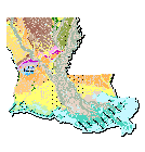
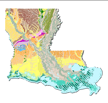
To create a digitized overlay of the Geologic Map of Louisiana for the Louisiana Geological Survey (LGS), highlighting geologic areas of the State of Louisiana that can be updated easily in the future digitally. The data set was digitized from a scanned version of a 1 : 500,000 scale hard copy map of the Geologic Map of Louisiana developed by the Louisiana Geological Survey. The classified data was derived from actual field identification and sampling performed by the Louisiana Geological Survey. Coverage is of the entire State of Louisiana.
Survey, Louisiana Geological , 1984, Geologic Map of Louisiana: Louisiana Geological Survey, Baton Rouge, LA.
Person who carried out this activity:
Mr. Steve HartleyData sources used in this process:
United States Geological Survey,
Senior Geographer/GIS Analyst
700 Cajundome Boulevard
Lafayette, LA 70506
USA
318/266-8543 (voice)
318/266-8616 (FAX)
steve_hartley@usgs.gov
- Hours_of_Service:
- 8 AM to 4 PM CST for phone calls. Any hours for e- mail or fax transmittal.
Person who carried out this activity:
Department of Geography and Anthropology, Louisiana State University
c/o Hampton Peele
Louisiana State University
Baton Rouge, LA 70803
(225) 388-3455 (voice)
hampton@lsu.edu
Data sources used in this process:
The accuracy is not based on a formal quantitative assessment. Field checking was not performed for this assignment. To attain a better estimate of accuracy, a formal re-evaluation of the geology of Louisiana would be necessary. No accuracy assessment was performed for this dataset during this project.
The accuracy of the dataset is dependant on the accuracy of the Geologic Map of Louisiana produced by the Louisiana Geological Survey of Baton Rouge, Louisiana, 1984.
none
none
Are there legal restrictions on access or use of the data?
- Access_Constraints:
- None currently, but be aware, as is possible in all government situations, other constraints may have been required and added since the compilation and completion of this metadata file.
- Use_Constraints:
- Acknowledgement of the National Wetlands Research Center as a data source would be appreciated in products developed from these data, and such acknowledgement as is standard for citation and legal practices for data sources is expected by users of this data. Sharing new data layers developed directly from these data would also be appreciated by NWRC staff (contact staff cited in Distribution Information). These are not enforceable constraints, but are highly desired or expected by the National Wetlands Research Center in exchange for the access and use of NWRC data sets.
These data are not legal documents and are not to be used as such. Users should be aware that comparison with other data sets for the same area form other time periods may be inaccurate due to inconsistencies resulting from changes in photo-interpretation and mapping conventions over time. See Access Constraints, for the NWRC Standard Data Liability Disclaimer.
Any downloading and use of these data signifies a user's agreement to comprehension and compliance with all stated constraints in this metadata. Insure all portions of metadata are read and clearly understood before using these data in order to protect both user and NWRC interests.
USGS's National Wetlands Research Center
c/o Steve Hartley
Senior Geographer/GIS Analyst (serving as spatial data request
700 Cajundome Blvd
Lafayette, Louisiana 70506
USA
318/266-8543 (voice)
318/266-8616 (FAX)
steve_hartley@usgs.gov
- Hours_of_Service:
- 8 AM to 4 PM CST for phone calls. Any hours for e-mail or fax transmittal.
Downloadable Data
NWRC Standard Data Liability Disclaimer (April 1997): Although these data have been processed successfully on a computer system at the Biological Resource Division, no warranty expressed or implied is made regarding the accuracy or utility of the data on any other system or for general or scientific purposes, nor shall the act of distribution constitute any such warranty. This disclaimer applies both to individual use of the data and aggregate use with other data. It is strongly recommended that these data are directly acquired from a Biological Resource Division server, and not indirectly through other sources which may have changed the data in some way. It is also strongly recommended that careful attention be paid to the contents of the metadata file associated with these data. The Biological Resource Division shall not be held liable for improper or incorrect use of the data described and/or contained herein, based on the description of appropriate/inappropriate used described in this metadata document. This data was developed and is meant to be used for the purpose of having a digital version of the data for the LGS. The distributor makes no claims as to the data's suitability for other purposes.These data are not legal documents and are not to be used as such. Users should be aware that comparison with other data sets for the same area from other time periods may be inaccurate due to inconsistencies resulting from changes in photo-interpretation and mapping conventions over time.
So, these data are provided "as is" and without any express or implied warranties, including, without limitation, the implied warranties of merchantability and fitness fordocument is solely for the purpose of providing specific information, and does not imply recommendation or endorsement by the U.S. Government.
| Data format: | Size: 10.146 |
|---|
3001, Inc.
c/o Hugh Phillips
GIS Analyst
3655 SW 2nd Ave., Suite 3C
Gainesville, FL 32607
(352) 379-3001 (voice)
(352) 377-4234 (FAX)
<URL:mailto:hphillips@gnv.3001data.cpm>