The need for systematic monitoring of the Nation's rivers increased in the 1960s and early 1970s with the passage of federal environmental legislation, including the Water-Quality Act of 1965 and the Clean Water Act in 1972 and its subsequent amendments. Additional monitoring was sought to provide more geographically comprehensive and uniformly-collected information on current water-quality conditions and to track changes in water quality resulting from the control of water pollution. Planning and management agencies, including the U.S. Environmental Protection Agency (EPA), interstate river-basin commissions, and selected state water agencies, were especially in need of more uniformly-collected national and regional water-quality information to address these needs. The paucity of such data complicated efforts to accurately describe river quality. Available water-quality records were often of short duration, plagued by frequent changes in the location, frequency, and methods of data collection, or lacked adequate coverage for a wide range of physical, chemical, and biological water properties (Wolman, 1971; Knopman and Smith, 1993). As a result, prior efforts to summarize the water-quality of U.S. streams and rivers were forced to rely extensively on anecdotal data (Wolman, 1971). As the lead agency responsible for assessing the Nation's water resources (U.S. Bureau of the Budget, 1964), the USGS responded to the need for improved national and regional water- quality information by initiating the NASQAN program in January 1973 (Fig. 1) to monitor the water quality of major rivers and streams in the United States (Ficke and Hawkinson, 1975).
Network objectives and station characteristics
The primary objectives of the NASQAN program are to (1)
measure the quantity and quality of stream water in major
watersheds of the United States, (2) describe spatial variability in
stream water quality, (3) detect long-term changes in stream water
quality, and (4) provide information to help guide future water-
quality assessments, possibly having more temporally- and spatially-
intensive components (Ficke and Hawkinson, 1975).
The selection of stream monitoring locations was aided by the Water Resources Council (WRC) hierarchial classification of hydrologic drainage basins of the United States (Seaber and others, 1987) consisting of 21 major regional drainage basins, 222 subregional basins, 352 accounting units, and 2150 cataloging units. NASQAN stations were located at the outlets of many of the accounting and cataloging units to satisfy one of the network's primary goals of accounting for chemical mass and water transported from the continent and its major interior watersheds. The median drainage area of NASQAN watersheds is about 4,000 square miles with about one-half of the watersheds (interquartile range) ranging from 1,000 to 15,000 square miles. The drainage areas of the watersheds span a considerable range from less than one square mile to over one million square miles (Table 1).
The location of monitoring stations on rivers throughout the United States according to hydrologic criteria has generally produced more geographically representative descriptions of national and regional water quality than are available from other monitoring networks (Smith and others, 1993; Smith and others, 1987b). These hydrologic criteria have avoided the types of biases common to many monitoring networks that were frequently designed to monitor local water-pollution problems. Moreover, the similarity of the population and land-cover characteristics of the NASQAN drainage basins to those of all accounting units in the conterminous United States (Table 1) suggests that, in general, the stations broadly represent many of the cultural factors influencing water quality. For example, the crop and forest areas expressed as a percentage of the total NASQAN drainage basin area typically range from less than 10 percent to about 50 percent with medians of 12 percent and 17 percent, respectively. Very similar land-cover characteristics are noted for all U.S. accounting units (Table 1). The distribution of population density for NASQAN watersheds is also very similar to that for U.S. accounting units. The median population density of the NASQAN watersheds is about 41 persons per square mile, and typically ranges from 14 to 108 persons per square mile (Table 1). By comparison, the median population density for the accounting units is 48 persons per square mile, and typically ranges from about 14 to 119 persons per square mile.
Constituent coverage
NASQAN has provided relatively consistent monitoring for a
large suite of constituents during its history. Water measurements
have included a set of approximately 85 physical, chemical, and
biological properties. All water properties historically monitored at
NASQAN stations, with the exception of pesticides, are published on
the CD-ROMs (Table 2).
This includes 63 water properties or 122
constituents including dissolved, suspended, and whole-water (i.e,
total) analyses of these properties. Organic pesticides were
measured in the water column and bed sediments at about 160
NASQAN stations from 1975 to 1982 as part of the National Pesticide
Water Monitoring Program (Feltz and others, 1971); however , these
data were not included on the CD-ROMs because of space limitations
and the high frequency of nondetects. These data have been
previously summarized by the USGS (Gilliom and others, 1985).
Most physical and field measurements, major ions, and nutrients have been regularly monitored at NASQAN stations throughout the 1973 to 1995 period of operation. Monitoring for several other constituents began after 1973 including radiochemicals (1975 at a subnetwork of 53 sites), measures of fecal bacteria (1976), organic carbon (dissolved and suspended in 1977), and alkalinity (field determinations in 1985). Several constituents were discontinued prior to 1995 including periphyton (1980), organic carbon (1981), phytoplankton (1981), and selected trace elements in 1982 and 1991. Whole-water analyses of trace elements were discontinued in 1982 due to budget reductions. Selected dissolved trace elements, including arsenic, beryllium, cadmium, chromium, copper, lead, mercury, and zinc, were discontinued in 1991 because of concerns about the introduction of contamination during the processing of samples in the field (Windom and others, 1991; Horowitz and others, 1994). USGS investigations of trace-element sample contamination raised important concerns about the accuracy of the data for these constituents prior to 1991. These studies led to the implementation of a new sample collection and processing protocol for low-level inorganic analyses in 1994 (Horowitz and others, 1994). The results of these investigations and related documents are provided on the CD-ROMs to assist in the proper use of trace-element data collected prior to 1991 (see the section entitled "National Network Field Techniques" for additional information).
Sampling frequency
NASQAN samples have been collected according to fixed time
intervals (i.e., uniform sampling). The time interval of sample
collection has typically ranged from quarterly to monthly according
to the constitutent and year
(Table 2). Trace elements,
radiochemicals, periphyton, phytoplankton, and organic carbon have
typically been sampled with the lowest frequency (ranging from 1 to
7 samples per year). Samples have periodically been collected more
frequently than monthly at some stations. These cases often include
"continuously"-monitored field measurements (e.g., temperature, pH,
specific conductance, dissolved oxygen) or supplemental monitoring
of various constituents as part of USGS District cooperative projects
or other federal or state programs [e.g., National Water Quality
Surveillance System-NWQSS (USEPA, 1976); USGS daily suspended
sediment stations].
Reductions in the sampling frequency of all constituents have occurred with time (Fig. 2) in response to budgetary constraints (see the following section "Historical changes in network operations" for a description of changes in network expenditures). Prior to 1982, monthly samples were collected at all NASQAN stations for most constituents. In 1982, most constituents were sampled bimonthly. After 1982, the sampling frequency of constituents was reduced to quarterly at many stations. The proportion of stations with bimonthly and quarterly sampling frequencies remained relatively constant from 1983 to 1995 with slightly more NASQAN stations sampled bimonthly than quarterly. During 1993 and 1994, in addition to the bimonthly and quarterly sampling frequencies used at most sites, samples were also collected five times per year at 81 and 120 sites, respectively. In 1995, in addition to bimonthly and quarterly sampling (107 stations), samples were collected at other frequencies (5, 3, or 2 times per year) at a total of 35 stations. NASQAN protocols established the recommended time periods for sample collection according to bimonthly and quarterly sampling frequencies as shown in Table 3.
The sampling of network sites according to fixed time intervals addresses several statistical and operational goals related to both the accuracy of trend detection methods and the efficiency of the collection of water-quality samples. The analysis and interpretation of time trends (objective 3) benefits from the use of statistically- independent water-quality observations that are equally spaced in time so as to give a temporally-unbiased representation of water- quality variations. Moreover, fixed interval sampling allows for efficient scheduling of site visits within the budgetary limits of the program. The disadvantage of fixed-interval sampling is the lack of intensive sampling during high flows, a necessary sampling feature to maximize the accuracy of estimates of the rates of constituent transport. Nevertheless, multi-year sampling at many of the NASQAN stations has produced instantaneous streamflow measurements that are approximately representative of the range of streamflow conditions at the sites (J. Weaver, U.S. Geological Survey, written communication, 1990). In addition, bias-corrected "rating- curve" load estimation techniques (Cohn and others, 1989; Gilroy and others, 1990) have been applied to instantaneous measurements and records of continuous daily streamflow at NASQAN sites to produce relatively reliable long-term estimates of annual mean flux (Cohn and others, 1992; Alexander and others, 1996a).
Historical changes in network operations
Changes in funding levels and network objectives during
NASQAN operations have affected the number and types of stations,
station sampling frequency, and the types of constituents analyzed.
The following discussion provides a brief overview of historical
changes in funding and network objectives.
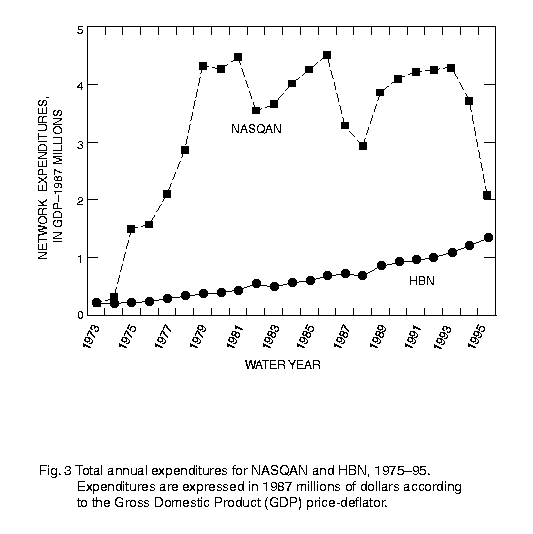
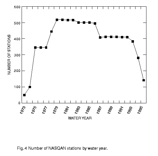
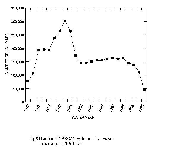
Figure 3 displays the expenditures for NASQAN over the period 1973 to 1995 in 1987 millions of dollars. Funding for NASQAN increased rapidly from 1973 to 1980 with a corresponding increase in the number of stations (Fig. 4). NASQAN began operation in January 1973 with 51 stations. An additional 50 stations were added in 1974, with significant expansion occurring in 1975 as the network grew to 345 stations. The largest number of stations in operation in any single year was 513 stations in 1980. A concomitant increase in the number of field and laboratory analyses also occurred over this period with the total number of water-quality analyses (excluding pesticides) expanding to slightly more than 300,000 in 1980 (Fig. 5).
In 1982, a large decrease of 21 percent in expenditures (Fig. 3) was absorbed through reductions in sampling frequency (a shift from monthly to bimonthly or quarterly sampling at all sites) and constituent coverage (see the previous two sections). The number of sites remained relatively unchanged at about 500 during 1982 and in subsequent years through 1986 (Fig. 4). Reductions in sampling frequency and constituent coverage caused the total number of water-quality analyses to decline by approximately one third from 1981 to 1982 (Fig. 5). These changes were preceeded by an approximate 12 percent decrease in the total number of water- quality analyses from 1980 to 1981 (Fig. 5) resulting in part from the discontinuation of periphyton and organic carbon. Although network expenditures increased in constant dollars from 1983 to 1986 (Fig. 3) and the number of water-quality analyses increased slightly from 1983 through the late 1980s, the number of analyses performed in any year after 1980 was no more than about 50 percent of the total number of analyses performed at the peak of network operations in 1980 (Fig. 5).
In 1987, the number of stations was reduced from 495 to 408 in response to a major review of network objectives. This and other administrative changes lowered expenditures from 1986 to 1987 by 27 percent and by an additional 8 percent from 1987 to 1988 (Fig. 3). From 1987 to 1992, the number of stations remained constant at about 410, with the number of bimonthly sites representing a slightly greater percentage of the total. From 1989 to 1993, funding increased with a notable gain in 1989 (Fig. 3). During this period, the number of water-quality analyses increased slightly through 1991 and then declined through 1995 (Fig. 5). Much of the increase in water-quality analyses during the late 1980s can be attributed to special high flow sampling implemented at about six stations and sampling conducted at about eight NASQAN stations as part of the pilot phase of the National Water Quality Assessment Program.
From 1993 to 1995, network expenditures declined significantly (Fig. 3) and the number of stations was sharply reduced from 384 to 142 (Fig. 4). Station operation costs also increased considerably during this period because of the implementation of an improved and more costly sampling protocol (see the section entitled "National Network Field Techniques" for more information). As a result, the number of water-quality analyses shows large declines from 1993 to 1995 (Fig. 5).
Major reviews of NASQAN in 1981, 1986, and 1995 led to various changes in network objectives, the types and number of stations, sampling frequency, and constituent coverage. Many of the changes resulting from these reviews are described in annual national network implementation memoranda (see a subsequent section entitled "National Network Field Techniques"). The 1981 review led to several changes in constituent coverage and sampling frequency beginning in 1982 and 1983, and included among other items the elimination of phytoplankton and organic carbon analyses and a modification of the nutrient schedule. The 1986 NASQAN review led to changes in the number and characteristics of the stations beginning in 1987. Network objectives were modestly revised to place greater emphasis on trend detection in smaller watersheds with more uniform land cover characteristics. The objective of accounting for mass transport was maintained although greater emphasis was placed on monitoring mass transport to major estuaries and significant fresh water bodies including the Great Lakes. The review of NASQAN led to the elimination of 90 stations that were either located downstream of certain reservoirs, located in proximity to other stations on the mainstem of large rivers, experiencing sampling problems, or located in small coastal drainages that were over-represented in the network. Thirty-one sites were added to the network in 1987 to provide better representation of certain land-cover types. The 1995 review of NASQAN led to an increased emphasis on the characterization of load for a wide range of water properties, including herbicides, in the largest drainage basins of the United States. Review recommendations were implemented in 1996 when the network was reduced to 31 stations in the Mississippi, Columbia, Colorado, and Rio Grande River Basins and five stations in major coastal drainages of the United States to accomodate a shift to more intensive sampling at each site.
Statistical analyses and interpretations of NASQAN data
Since the beginning of NASQAN, the data have been used to
satisfy stream water-quality information needs at a variety of
geographic levels. Many of these applications of the data appear in
the publications listed in the national network bibliography in the
appendix. Uses of the data have included summary and
interpretative investigations at the national (e.g., Smith and others,
1987a; Lettenmaier and others, 1991; Briggs and Ficke, 1977) and
regional (e.g., Alexander and others, 1996a) geographic levels.
NASQAN data have also been used extensively in more spatially
detailed analyses at the state (Schertz, 1990; Schertz and others,
1994; Hay and Campbell, 1990; Petersen, 1992) and accounting unit
(e.g., Rinella, 1986; Graczyk, 1986; Hainly and others, 1989) levels.
The publications listed in the appendix cover a range of time periods
and include analyses of trends in water quality and their causes and
studies of chemical flux. NASQAN data have also served as baseline
information for developing and illustrating many statistical
techniques (e.g., Smith and others, 1982; Hirsch and others, 1982;
Hirsch and others, 1991; Alexander and others, 1993) and have aided
the development of computerized water-quality data management
and trend analysis systems (Crawford and others, 1983; Schertz and
others, 1991).
The HBN was established in 1958 by the USGS to provide a standard base of hydrologic data from minimally disturbed watersheds that could be used to investigate naturally-induced changes in streamflow and water quality (Langbein, 1968; Cobb and Biesecker, 1971). Leopold (1962a, 1962b) originally promoted the goal of establishing a baseline or "benchmark" monitoring network to investigate the influence of terrestrial and climatic factors on streamflow and water chemistry independent of the cultural effects common in most watersheds of the United States. Data from the network has served several purposes including the investigation of naturally-induced changes in hydrologic variables, the investigation of the statistical characteristics of stationary hydrologic time series, and the study of the effects of atmospherically-derived pollutants on stream water quality.
HBN watersheds were selected on the basis of the following criteria (Cobb and Biesecker, 1971):
2. Ground water within the basin will not be affected by pumping from wells.
3. Conditions favorable for accurate measurement of streamflow, chemical and physical quality of water, ground-water conditions, and the various characteristics of weather, principally precipitation.
4. The probability is small of special natural changes due to such things as major activities of beavers, overgrazing or overbrowsing by game animals, or extensive fires.
HBN selection criteria resulted in the placement of many monitoring stations in national parks, wilderness areas, State parks, national forests, and specially-protected areas set aside for scientific investigations. A few stations were located in moderately disturbed watersheds (e.g., agriculture, logging) in cases where land use was not expected to change radically. A complete description of the watershed characteristics is provided by Cobb and Biesecker (1971) and Biesecker and Leifeste (1975).
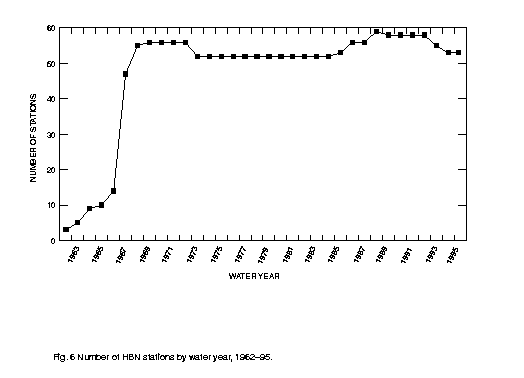
The HBN has consisted of 63 watersheds located in 37 states (Fig. 1). Most stations began operation in the mid to late 1960's with the earliest date of water-quality data collection in 1962 (see Fig. 6). Virtually all sites were in operation by 1968 (Fig. 6). HBN watersheds represent a wide variety of natural environments including various geologic and climatic provinces and a diversity of vegetation and soils. Elevations of the watersheds range from about 100 to over 14,000 feet above sea level and vegetation ranges from sparse desert growths to dense coniferous forests (Cobb and Biesecker, 1971). In general, basins of an intermediate size were sought for the network. The median basin size is 57 square miles (25th and 75th percentiles of 24 and 99 square miles, respectively) with basin sizes ranging from 2 to 2000 square miles.
The physical, chemical, and biological constituents (Table 2) and the methods of sample collection and laboratory analysis are identical to those used in NASQAN during the 1973 to 1995 period. The sampling frequency of HBN stations underwent changes in 1983 in response to funding reductions (Fig. 3). Prior to 1983, monthly samples were collected at 34 of the approximately 52 HBN stations. Bimonthly samples were collected at 14 stations and quarterly samples were collected at four stations. Beginning in 1983, most HBN stations were sampled quarterly (43 sites) with the remaining sites sampled bimonthly (10 sites) or monthly (2 sites).
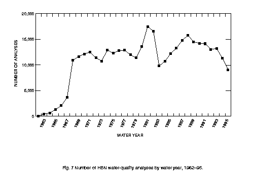
Funding at HBN sites steadily increased throughout the history of the program with modest reductions occurring in 1983 and 1988 (Fig. 3). The number of water-quality analyses similarly increased over much of the period of operation (Fig. 7). A major decline in the number of analyses occurred in 1983 corresponding to the reduction in sampling frequency at network stations. Decreases in analyses in 1994 and 1995 were related to reductions in the number of sites (Fig. 6) and the number of constituents including radiochemicals and nutrients.
The network has provided excellent opportunities to investigate the effects of atmospherically-derived pollutants on stream water quality (especially sulfate and nitrogen) independent of the effects of culturally-derived land disturbances common to most watersheds (e.g., Smith and Alexander, 1986). Although the HBN stations were selected to control for the effects of anthropogenic influences on water quality, atmospherically-derived pollutants (believed to be mostly of human origin) are a major source of sulfate and nitrate in many of the watersheds (Smith and Alexander, 1983). The influence of atmospheric pollutant sources, particularly fossil fuel residuals of nitrogen and sulfur, became increasingly known after the network began, as researchers documented the effects of increasing atmospheric emissions of nitrogen and sulfur on the stream chemistry of many northeastern watersheds (Likens and others, 1980; NRC, 1983) and HBN basins (Smith and Alexander, 1983; Smith and Alexander, 1986; Kramer and others, 1986).
A detailed survey of the network was conducted in the early 1990s to evaluate the integrity of each watershed with respect to the original network objectives. This included assessments of the effects of geologically- and atmospherically-derived substances such as sulfur on stream chemistry as well as inventories of land use practices in the watersheds. In some of the watersheds, land cover changes occurred over time, most notably with respect to agriculture and logging practices, and may have affected the water chemistry measured at the stations. The survey led to the elimination of six stations and the addition of two sites in 1993 and 1994.
The national network bibliography in the appendix includes publications related to HBN. These include publications describing the origins of the network (e.g., Cobb and Biesecker, 1971; Leopold, 1962b) as well as many national and regional investigations using the data (e.g., Lawrence, 1987; Smith and Alexander, 1986; Lins, 1986). Also, many site-specific studies were conducted including several investigations of the water-quality data from McDonalds Branch in New Jersey (Johnson, 1979a; Johnson, 1979b; Lord and others, 1990, Johnsson and Barringer, 1993; Morgan, 1984; Turner and others, 1985) and other selected HBN watersheds in the northeastern United States (Hainly and Ritter, 1986; Peters and others, 1982; Stoddard, 1991).
The Office of Water Quality (OWQ) of the USGS's Water Resources Division has administered the NASQAN and HBN. Sample collection is conducted by USGS local District offices under the supervison of the OWQ. Samples were analyzed in USGS District laboratories prior to about 1973, and in the USGS Central Laboratory system after this date (see the following section on laboratory methods for additional details).
During the period of network operations, the OWQ periodically released protocols specifying the accepted field sampling, processing, and measurement procedures and required laboratory analytical methods for national network samples. Many of the national network field and laboratory protocols were released in the form of internal USGS technical memoranda. Also, beginning in the early 1980s, the OWQ annually communicated network protocols to the local field offices as part of the national network memoranda. These memoranda described changes in network procedures and monitoring station locations from the previous year, and provided regular updates on a wide range of network-related activities.
As part of network operations, the OWQ implemented the recommendations of periodic reviews by USGS committees of national network monitoring objectives and station design. For example, major reviews of the networks were conducted in 1981, 1986, and 1995. These reviews have resulted in adjustments in network objectives, the number and location of stations, constituent coverage, and sampling frequencies (see the discussion of selected reviews in the previous two sections). Selected changes that resulted from these reviews are documented in annual national network memoranda.
The OWQ's broader responsibilities of providing guidence to the Districts in the selection and use of USGS field and laboratory water- quality methods have also directly benefited national network operations. The OWQ has the responsibility to ensure that District water-quality activities include the use of standard methods of data collection and analysis, the application of effective quality-assurance practices, and the training of technical personnel. The OWQ conducts regular technical reviews of District water-quality activities to evaluate these practices. For example, a program of regular evaluation of the accuracy of field determinations (pH, alkalinity, specific conductance, and dissolved oxygen) is coordinated with regional and District personnel. National, regional, and District training in water-quality sample collection and processing methods has also been coordinated by the OWQ and regional and District water-quality specialists. A detailed discussion of USGS water- quality monitoring and quality-assurance activities is provided by Friedman (1993).
The OWQ has also periodically developed and evaluated new field and laboratory methods, that are used by the national networks, to address sampling problems or to improve measurement accuracy. For example, a new sampling and processing protocol for low-level inorganic analyses was developed and implemented in 1994 in response to concerns about trace-element contamination. This method now supports many District investigations and the operations of the national networks. Other studies have also been initiated by the OWQ to evaluate nutrient preservation techniques and alkalinity determinations. Many of the historical records of actions resulting from these investigations are contained in USGS water-quality technical memoranda referenced in the next section of the report.
Standard methods of sample collection, processing, and field measurement have been used throughout the history of the national networks. Detailed descriptions of these methods can be found in Rainwater and Thatcher (1960), Edwards and Glysson (1988), Ward and Harr (1990), Britton and Greeson (1989), Guy and Norman (1970), Horowitz and others (1994), and USGS memorandum QW74_11, which provides field instructions for NASQAN [references to USGS memoranda in this paper are of the form XXyy_nn, where XX identifies the originating office (QW = Office of Water Quality; NL = National Water Quality Laboratory), yy is the year of release, and nn is the alphanumeric identifier for the year's memoranda]. A summary of important changes in field methods, constituent coverage, and field sample contamination during the operation of the networks is given in Table 4. A list of important USGS memoranda documenting network operations and changes in field and laboratory methods is presented in Table 5. The text and illustrations for these memoranda can be found on the CD-ROMs (see Alexander and others, 1996b).
Virtually all physical, chemical, and biological samples are collected from the water column at network stations. The exceptions include pesticides in bottom sediment samples and periphyton measurements based on the use of an artificial substrate method (see memorandum QW74_11 for details of the periphyton methods). Field measurements at network sites include instantaneous discharge, barometric pressure, water temperature, air temperature, specific conductance, pH, dissolved oxygen, fecal bacteria, and alkalinity (note changes in alkalinity procedures in Table 4). Daily mean values of streamflow are obtained from continuous river stage records, and are available for most network stations. In some cases, records of daily streamflow values are available from nearby gaging stations.
Water-column samples, that are representative of the stream cross section, are collected using depth- and width-integrated sampling techniques (Edwards and Glysson, 1988). These techniques require the collection of subsamples at several locations in the stream cross section using approved depth-integrating samplers. One of two procedures (Edwards and Glysson, 1988), Equal Width Increment (EWI) or Equal Discharge Increment (EDI), are used to systematically determine these sampling locations. Network protocols recommend annual and seasonal surveys of water temperature, pH, specific conductance, and dissolved oxygen variations in the stream cross section to assist in determining the appropriate number of vertical sampling locations. The number of locations depends on the variability of water quality in the cross section and the width of the river, and can range from a few to as many as 50; however, from four to 20 sampling locations have been commonly used at most sites.
For whole-water (i.e., unfiltered) analyses, subsamples from the cross section were either composited directly into bottles for shipment to the laboratory (prior to 1972) or composited into a "splitting" device (after about 1972). A Teflon sediment sample splitter became available for use in October 1972 (QW73_07). After August 1976, a polypropylene "churn splitter" was required for sample collection at national network sites (QW76_24T). Sample bottles are filled from the churn splitter while the churn paddle is moved vertically at a specified rate to ensure the suspension of particles so that a representative sample can be obtained.
Analyses of filtered samples provide an operationally-defined determination of "dissolved" chemical constituents. Samples analyzed for "dissolved" chemical species are pumped through 0.45 membrane filtration device (Rainwater and Thatcher, 1960). Since February 1977 ( QW77_04), a 142 millimeter diameter, 0.45 micrometer pore-size, tortuous-path membrane filter in a plastic plate filter has been used (Ward and Harr, 1990). In 1993, 0.45 micrometer (um) pore size capsule filters began to be used at many sites.
Fecal bacteria samples are not obtained from the splitter device, but are taken as a surface "grab" sample from the centroid of streamflow. Bacteria concentrations are measured using membrane filter techniques (Britton and Greeson, 1989). Fecal coliform counts were determined for samples filtered with a 0.45 um filter pore size prior to 1976 (Table 4). After this date, a 0.70 um filter pore size was required to ensure accurate fecal coliform counts. Either a 0.45 or 0.70 um filter pore size was acceptable for determining fecal streptococci counts, however, field personnel tended to use the same size filters as those used for fecal coliform determinations. In 1991, a 0.45 um filter pore size was required for use in fecal streptococci determinations to comply with prescribed TWRI methods (Table 4). A study of the effects of the two pore sizes on analytical results based on data collected at NASQAN and HBN stations in 1990 indicates no statistically significant differences in methods (p=0.94 for a Wilcoxon signed-ranks test) for fecal streptococci determinations (QW91_FS). The observed differences in analytical results appear to reflect random measurement errors intrinsic to the methods with no evidence of upward or downward bias based on the symmetry of the distribution of differences. For 415 pairs of fecal streptococci counts, the distribution of differences in counts has a median of zero percent (difference between counts for 0.70 filter size and counts for 0.45 filter size) and 25th and 75th percentiles of -16.5 percent and 14.6 percent, respectively.
Selected samples were stabilized with chemical treatments in the field according to laboratory specifications prior to their transport to the laboratory. Filtered and unfiltered samples analyzed for trace elements were treated with nitric acid to maintain metals in solution. A preservative was routinely added to phytoplankton samples to reduce biological activity. Similarly, nutrient samples were treated with a biocide preservative and/or chilled during most of the period of network operations. The methods of nutrient preservation have changed over time according to USGS and network guidelines ( QW72_09; QW80_26; QW85_07; QW94_16; QW93_04; see also the next section entitled "National Network Laboratory Techniques"). Beginning in 1973, national network protocols required all water samples to be chilled to 4 degrees C. and promptly transported to a USGS laboratory.
The analytical methods for alkalinity, bicarbonate, and carbonate have changed over time due to changes in the stage of analysis (i.e., field and laboratory), the method of determination (i.e., fixed-endpoint and incremental titration), and sample filtration (Table 6). Also, changes in guidelines for storage of the data have led to the proliferation of numerous alkalinity parameter codes, especially after 1980 when field parameter codes became available (QW81_04; QW80_27; QW82_05). In producing the CD-ROM data sets, national network data for alkalinity, bicarbonate, and carbonate were compiled from various parameter codes according to methods prescribed in memorandum QW88_05 (see also QW87_01) and records of network protocols (QW84_16; QW85_19). The data aggregation methods prescribed in these memoranda, and modified for the CD-ROM data to reflect network operations, assigns the data to the appropriate parameter and method codes to provide records suitable for statistical analysis.
Table 6 presents the parameter/method codes and time periods applicable to the alkalinity, bicarbonate, and carbonate data collected at national network stations. Fixed-endpoint titration methods were required for national network alkalinity determinations throughout the operation of the networks. Alkalinity methods incurred two changes during network operations (Table 4): (1) the stage of analysis was changed from the laboratory to the field on October 1, 1984, and (2) filtered samples were required beginning on October 1, 1985. Alkalinity determinations by incremental titration were optional for network samples. National network protocols required field determinations of bicarbonate and carbonate for filtered samples beginning on October 1, 1985 (Table 4). Bicarbonate and carbonate determinations were optionally performed on unfiltered samples by fixed-endpoint (00440A, 00445A) and by incremental (00450B, 00447B) titration methods prior to October 1, 1985.
Standard methods of laboratory processing and analysis (Rainwater and Thatcher, 1960; Skougstad and others, 1979; Britton and Greeson, 1987; Fishman and Friedman, 1989; Faires, 1993; Patton and Truitt, 1992; Fishman and others, 1994) have been applied to network samples during the period of operations. The standard analytical schedules employed by the USGS laboratories specify the sample characteristics (e.g., filtration, treatment, and storage) required for analysis, and make available a variety of possible analyses by constituent group. The analytical schedules for national network stations are selected annually by the OWQ.
The "total" form reported for national network constituents reflect different characteristics of the analytical methods and the water-suspended sediment mixture of the samples (Table 7). Total analyses of phosphorus, Kjeldahl (organic plus ammonia) nitrogen, and carbon represent a complete digestion of the whole-water (i.e., unfiltered water-suspended sediment) sample. In contrast, analyses of four "total" nutrient species (nitrite, nitrate+nitrite, ammonia, and orthophosphate) were performed on samples "decanted" in the laboratory (Skougstad and others, 1979) to avoid measurement interferences associated with particulate material. Because the results of these analyses are not statistically separable from analytical results based on "dissolved" samples filtered in the field, "total" analyses for these four nutrient species were discontinued on October 1, 1994 (Table 8). Trace-element analyses on unfiltered samples (i.e., whole water) are based on total recoverable methods (Table 7).
Selected laboratory analytical results have changed periodically because of advances in methods related to instrumentation and processing techniques and because of changes in measurement accuracy related to sample contamination. Some of the more important method changes that may have relevance to the use and interpretation of national network data are listed in Table 8.
Prior to about 1973, national network chemical samples from the HBN were analyzed in one of 22 local District laboratories. With the advent of automated analytical equipment, these laboratories were consolidated into three centralized laboratories in 1973 (Salt Lake City, Utah; Atlanta, Georgia; and Albany, New York) to improve the efficiency of operations (Durum, 1978). In 1976, operations at the Salt Lake City laboratory, the proto-type of the USGS centralized laboratory system, were transferred to Denver, Colorado. The Salt Lake City laboratory (and later Denver) served all states west of the Mississippi River with the exception of Texas, Arkansas, Missouri, and Oklahoma. The Albany laboratory was operated as a temporary component of the centralized lab system from April, 1973 to May, 1977 (Durum, 1978; B. Malo, oral communication). This laboratory typically served the New England states of New York, Connecticut, Massachusetts, Maine, New Hampshire, Rhode Island, and Vermont. The Atlanta laboratory served states in the eastern United States, which included those served by the Albany laboratory after 1977. In April 1986, the Atlanta laboratory was closed, and the Denver lab became the National Water Quality Laboratory (NWQL), where all national network chemical samples were analyzed. A detailed history of USGS laboratories prior to about 1976 is given by Durum (1978).
Suspended sediment concentration and particle size have been analyzed during the operations of the national networks at numerous sediment laboratories located in District offices throughout the United States.
Analytical results of USGS laboratories are verified through an internal quality-assurance program which includes the use of proven documented methods, method validation procedures, and technician training (see Pritt and Raese, 1992 for a description of NWQL quality-assurance practices). Method validation has included the regular analysis of natural-matrix water reference samples, standard solutions, and blanks to evaluate the measurement variability and bias. Water reference samples have been part of the quality- assurance practices of USGS laboratories since 1962 when the Standard Reference Water Sample Program began a semi-annual evaluation of the analytical methods of participating laboratories (Durum, 1978). Since 1981, an external, independent quality- assurance program called the Blind Sample Program (BSP) has validated the analytical results of the USGS central laboratories (this program is discussed in the next section of the paper). Water reference samples from the Standard Reference Water Sample Program have also been used by the laboratory since 1981 to conduct regular internal blind evaluations of method performance. Additional discussion of historical quality-assurance practices of USGS laboratories is provided by Friedman (1993).
Laboratory analytical results for national network stations are also reviewed by District personnel responsible for the collection of the data. Analytical results are transmitted to District computers where the data are reviewed and verified for accuracy. Within approximately 30 days, the District may request the reanalysis of samples believed to contain errors; after this time samples may be discarded by the laboratory.
All available water-quality records were retrieved for 63 chemical, biological, and physical properties of water [122 properties including analyses of filtered (dissolved), unfiltered (total or total- recoverable), and particulate samples] for the approximate time periods 1973-95 for NASQAN stations and 1962-95 for HBN stations. The data include alkalinity, bicarbonate, and carbonate parameter and method codes listed in Table 6. The alkalinity data listed in Table 6 for the required network parameter and method codes are generally preferable for statistical analysis because of the larger number of observations and broader geographic coverage. We did not include laboratory determinations of bicarbonate and carbonate on the CD-ROMs. National network data on organic pesticides were excluded from the CD-ROMs because of space limitations and the high frequency of nondetected values [the user is referred to Gilliom and others (1985) for a summary of these data]. The final selection of water-quality constituents for inclusion on the CD-ROMs was based on USGS water-quality technical memoranda describing the constituents historically measured at national network stations and statistical summaries of the frequency of observations by constituent.
Water-quality data for most national network stations were retrieved from the USGS's National Water Information System (NWIS) located on local USGS District computer systems. For efficiency, selected water-quality data were obtained from the USGS's centralized data repository, the National Water Data Storage and Retrieval System (WATSTORE), located on a mainframe computer in Reston, Virginia. These additional retrievals from WATSTORE included data for most stations from January 1, 1994 to September 30, 1995, data for 1962-71 for all HBN stations, and data for selected time periods for about 30 stations. Data published on the CD-ROMs were extracted directly from these computer systems with no additional checks for outliers or unusual values.
For each water-quality value, we report the sample-collection agency, the laboratory analytical agency, the laboratory analytical method code, and relevant remark codes. For years since the early to mid 1980's, agency sample collection and analysis codes and laboratory analytical method codes may assist in identifying non- network data that may have been collected at some national network stations as part of local investigations. These agency and analytical method codes are also required to properly use the Blind Sample Program data on measurement accuracy (see the following sections for details).
The agency sample collection and agency laboratory analysis codes have been maintained in the USGS water-quality data base since the early 1980s. For years 1982 and later, these codes are available for more than 96 percent of the samples collected and analyzed. The laboratory analysis codes are also reported for 75 to 80 percent of the samples from 1979 to 1981. Agency names associated with the sample collection and laboratory analysis codes were obtained from the NWIS system (J. Briggs, U.S. Geological Survey, written communication, 1995). A single USGS laboratory analysis agency code (01028) may periodically appear in the data base prior to 1986 when more than one USGS central laboratory was operational (e.g., agency laboratory analysis code 80020 for Denver and 80010 for Atlanta). In these cases, the USGS laboratory responsible for the reported determination can only be assumed based on the approximate description of USGS laboratory jurisdictions presented in the previous section.
The laboratory analytical method codes have been maintained in the USGS water-quality data base since 1985. For years 1985 and later, the analytical method codes are reported for more than 90 percent of the analytical determinations. Descriptive information for 209 NWQL methods used to analyze 76 of the 122 constituents are published on the CD-ROM. This information, applicable to the 1985- 95 time period, includes the parameter name, parameter code, analytical method name, analytical method code, laboratory method reporting limit, and the relevant USGS publication (S. Glodt, U.S. Geological Survey, NWQL, written communication, 1996). Other analytical methods not listed in this file may have been used to analyze some of these 76 constituents; however, information on these methods was unavailable at the time of CD-ROM production. The remaining 46 (of 122) constituents include 17 laboratory-analyzed parameters with codes unavailable at the time of production of the CD-ROMs, 27 field parameters, and 2 computed parameters. The 17 constituents without laboratory analytical method codes on the CD- ROMs include one trace element (vanadium), four radiochemicals, and 12 biological constituents (these predated the use of method codes). Although method codes are reported in the water-quality data base for the 27 field and two computed parameters, these codes are not officially supported and maintained by the USGS.
Daily mean values of streamflow were obtained from WATSTORE. The records published on CD-ROM were selected for time periods corresponding to the water-quality data (i.e., temperature). Daily streamflow data are available for 654 of the 679 national network water-quality stations. For 79 of these stations, the streamflow is obtained from a nearby gaging station (61 stations; 2 streamflow gages serve one NASQAN site) or, in a minority of cases, a relocated NASQAN station (19 stations). Records of daily streamflow were not available for 25 of the water-quality stations at the time of publication. For many of these stations, daily streamflow records may be available from other federal agencies (e.g., Corps of Engineers).
Information on station attributes including station name, hydrologic unit code, FIPS code, drainage area, latitude, and longitude were obtained from the WATSTORE station header file. Population data for 1990 (U.S. Bureau of Census, 1991) and land-cover statistics for 1987 (U.S. Soil Conservation Service, 1989) are reported for 507 NASQAN watersheds digitized from 1:2 million scale hydrologic unit maps. Where NASQAN watershed boundaries were unavailable in digital form or are indeterminant, the population and land-cover statistics for the accounting unit containing the NASQAN station are reported (85 of 679 stations). Population and land-cover data are not reported for 26 NASQAN stations located outside of the conterminous United States and all 63 HBN stations (watersheds in the HBN were considered to be too small to accurately report these statistics). To obtain watershed statistics on population and land cover, counties were intersected with NASQAN watershed boundaries and Water Resources Council accounting units in a geographic information system. The data were disaggregated from the county to watershed level in proportion to the area shared by both. Other information on WRC hydrologic units are also reported, and include drainage area statistics, names, and narrative (Slack and Landwehr, 1992). Information on the dates of relocation of NASQAN stations is reported on the CD-ROMs, and was obtained from national network records.
We have included on the CD-ROMs 60 selected USGS technical memoranda documenting national network operations, important changes in field and laboratory methods, and cases of sample contamination and biases in analytical results (Table 5). These previously unpublished internal memoranda provide a significant source of technical information relevant to the use and interpretation of the national network data. Many of the specific events documented by the technical memoranda are highlighted in the discussion of field and laboratory methods in the previous two sections of the report (see Tables 4 and 8).