Data Series 799
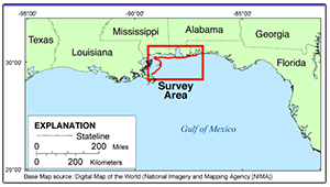
SummaryThe U.S. Geological Survey (USGS) conducts baseline and storm response photography missions to document and understand the changes in vulnerability of the Nation's coasts to extreme storms (Morgan, 2009). On February 7, 2012, the USGS conducted an oblique aerial photographic survey from Pensacola, Fla., to Breton Islands, La., aboard a Piper Navajo Chieftain at an altitude of 500 feet (ft) and approximately 1,000 ft offshore. This mission was flown to collect baseline data for assessing incremental changes since the last survey, and the data can be used in the assessment of future coastal change. The photographs provided here are Joint Photographic Experts Group (JPEG) images. The photograph locations are an estimate of the position of the aircraft and do not indicate the location of the feature in the images (see the Navigation Data page). These photos document the configuration of the barrier islands and other coastal features at the time of the survey. The header of each photo is populated with time of collection, Global Positioning System (GPS) latitude, GPS longitude, GPS position (latitude and longitude), keywords, credit, artist (photographer), caption, copyright, and contact information using EXIFtools (Subino and others, 2012). Photographs can be opened directly with any JPEG-compatible image viewer by clicking on a thumbnail on the contact sheet. Table 1 provides detailed information about the assigned location, name, data, and time the photograph was taken along with links to the photograph. In addition to the photographs, a Google Earth Keyhole Markup Language (KML) file is provided and can be used to view the images by clicking on the marker and then clicking on either the thumbnail or the link above the thumbnail. The KML files were created using the photographic navigation files (see the Photos and Maps page). |
First posted October 31, 2013 For additional information contact: Part or all of this report is presented in Portable Document Format (PDF). For best results viewing and printing PDF documents, it is recommended that you download the documents to your computer and open them with Adobe Reader. PDF documents opened from your browser may not display or print as intended. Download the latest version of Adobe Reader, free of charge. |
Morgan, K.L.M., Krohn, M.D., Doran, K., and Guy, K.K., 2013, Baseline coastal oblique aerial photographs collected from Pensacola, Florida, to Breton Islands, Louisiana, February 7, 2012: U.S. Geological Survey Data Series 799, https://pubs.usgs.gov/ds/0799.
Project Summary
Getting Started
Report Organization
List of Figures
References Cited
Acknowledgments
Information Statement
System Requirements
Contact

![]() U.S. Department of the Interior |
U.S. Geological Survey
U.S. Department of the Interior |
U.S. Geological Survey
URL: http://pubsdata.usgs.gov/pubs/ds/0799/index.html
Page Contact Information: GS Pubs Web Contact
Page Last Modified: Monday, 28-Nov-2016 19:26:48 EST
