Data Series 829
1U.S. Geological Survey.
2Idaho Power Company, Boise, ID 83702.
U.S. Department of the Interior
U.S. Geological Survey
St. Petersburg Coastal and Marine Science Center
Page Contents: |
||||
 |
||||
This Digital Versatile Disc (DVD) publication was prepared by an agency of the United States Government. Although these data have been processed successfully on a computer system at the U.S. Geological Survey, no warranty expressed or implied is made regarding the display or utility of the data on any other system, nor shall the act of distribution imply any such warranty. The U.S. Geological Survey shall not be held liable for improper or incorrect use of the data described and (or) contained herein. Reference herein to any specific commercial product, process, or service by trade name, trademark, manufacturer, or otherwise does not constitute or imply its endorsement, recommendation, or favoring by the United States Government or any agency thereof.
This disc is readable on any computing platform that has standard DVD driver software installed. The minimum software requirements are a Web browser, a Portable Document Format (PDF) reader, and a text editor. If you cannot fully access the information on this page, please contact USGS Information Services at infoservices@usgs.gov or 1-888-ASK-USGS.
To access the information contained on this disc, use a Web browser to open the file index.html. This report is divided into seven sections: Acronyms and Abbreviations, Disc Contents, Navigation Data and Maps, Subbottom Profiles, Field Activity Logs, FGDC Metadata, and Software. Links at the top and bottom of each page provide access to these sections. This report contains links to the USGS and collaborators or other resources that are only accessible if access to the Internet is available while viewing these documents.
This disc contains a readme (2-KB text file) document, which provides a brief description of the report; a folder containing SEG Y binary data files; GIS files; and all the Hypertext Markup Language (HTML) files, folders, and images used to produce the Web pages included in this report. The Disc Contents page contains a diagram with locations and links to all files and folders contained on this disc.
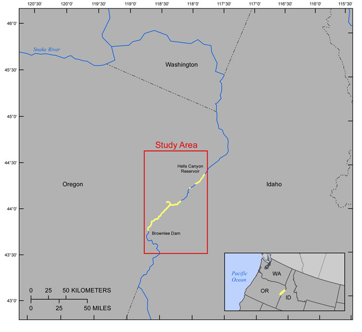
From March 16 - 31, 2013, the U.S. Geological Survey in cooperation with the Idaho Power Company conducted a geophysical survey to investigate sediment deposits and long-term sediment transport within the Snake River from Brownlee Dam to Hells Canyon Reservoir, along the Idaho and Oregon border; this effort will help the USGS to better understand geologic processes. This report serves as an archive of unprocessed digital chirp subbottom data, trackline maps, navigation files, Geographic Information System (GIS) files, Field Activity Collection System (FACS) logs, and formal Federal Geographic Data Committee (FGDC) metadata. Gained (showing a relative increase in signal amplitude) digital images of the seismic profiles are also provided. Refer to the Acronyms page for expansions of acronyms and abbreviations used in this report.
The USGS St. Petersburg Coastal and Marine Science Center (SPCMSC) assigns a unique identifier to each cruise or field activity. For example, 13GFP01 tells us the data were collected in 2013 during the first field activity for that project in that calendar year and GFP is a generic code that represents efforts related to Geological Framework Processes. Refer to http://walrus.wr.usgs.gov/infobank/programs/html/definition/activity.html for a detailed description of the method used to assign the field activity ID.
All chirp systems use a signal of continuously varying frequency; the EdgeTech SB-424 system used during this survey produces high-resolution, shallow-penetration (typically less than 50 ms) profile images of sub-surface stratigraphy. The towfish contains a transducer that transmits and receives acoustic energy and is typically towed 1 - 2 m below the water surface. As transmitted acoustic energy intersects density boundaries, such as the river bottom or sub-surface sediment layers, some energy is reflected back toward the transducer, received, and recorded by a PC-based seismic acquisition system. This process is repeated at regular time intervals (for example, 0.125 s) and returned energy is recorded for a specific duration (for example, 50 ms). In this way, a two-dimensional (2-D) vertical image of the shallow geologic structure beneath the ship track is produced. Figure 2 displays the acquisition geometry. Refer to table 1 for a summary of acquisition parameter.
The archived trace data are in standard Society of Exploration Geophysicists (SEG) SEG Y rev. 0 format (Barry and others, 1975); the first 3,200 bytes of the card image header are in American Standard Code for Information Interchange (ASCII) format instead of Extended Binary Coded Decimal Interchange Code (EBCDIC) format. The SEG Y files may be downloaded and processed with commercial or public domain software such as Seismic Unix (Cohen and Stockwell, 2010). See the How To Download SEG Y Data page for download instructions. The Web version of this archive does not contain the SEG Y trace files. These files are very large and would require extremely long download times. To obtain the complete DVD archive, contact USGS Information at 1-888-ASK-USGS or infoservices@usgs.gov. The printable profiles provided here are GIF images that were processed and gained using SU software and can be viewed from the Profiles page or from links located on the trackline maps; refer to the Software page for links to example SU processing scripts. The SEG Y files are available on the DVD version of this report or on the Web, downloadable via the USGS Coastal and Marine Geoscience Data System (http://cmgds.marine.usgs.gov). The data are also available for viewing using GeoMapApp (http://www.geomapapp.org) and Virtual Ocean (http://www.virtualocean.org) multi-platform open source software.
Detailed information about the navigation system used can be found in table 1 and the FACS logs. To view the trackline maps and navigation files, and for more information about these items, see the Navigation page.
NOTE: Due to system malfunctions, no data were collected for lines 13GFP01_10, 13GFP01_27, 13GFP01_30, 13GFP01_45, 13GFP01_50 and 13GFP01_70. Line 13GFP01_01 lost navigation data after shot 15837 and there is an unexplained jump in the day of year from 72 to 76 at shot 10494. Line 13GFP01_31 does not have navgation data until shot 16277 and line 13GFP01_39 only has navigation until shot 5344 (please see the operation (428-KB PDF) log for additional information).Funding for this study was provided by the USGS Coastal and Marine Geology Program (CMGP) and Idaho Water Science Center (IWSC). This document was improved by the reviews of Lisa Robbins and Nancy DeWitt of the USGS - St. Petersburg, FL.
Disc Image Credit: Image was captured by NASA's Landsat-7 (http://landsat.gsfc.nasa.gov/) satellite on September 19, 2002 and created by Jesse Allen, using Landsat data provided by the USGS. Available online at http://eoimages.gsfc.nasa.gov/images/imagerecords/37000/37320/hellscanyon_l7_2002262_lrg.jpg.
Barry, K.M., Cavers, D.A., and Kneale, C.W., 1975, Recommended standards for digital tape formats: Geophysics, v. 40, no. 2, p. 344-352. Also available on-line at http://www.seg.org/resources/publications/misc/technical-standards.
Cohen, J.K., and Stockwell, J.W., Jr., 2010, CWP/SU: Seismic Unix Release 41: A free package for seismic research and processing: Center for Wave Phenomena, Colorado School of Mines. Available online at http://www.cwp.mines.edu/cwpcodes/.
Zihlman, F.N., 1992, DUMPSEGY V1.0: A program to examine the contents of SEG Y disk-image seismic data: U.S. Geological Survey Open-File Report 92-590, 28 p. Also available online at http://pubs.er.usgs.gov/usgspubs/ofr/ofr92590.
Forde, A.S., Dadisman, S.V., Flocks, J.G., Fosness, R., Welcker, C., and Kelso, K.W., 2014, Archive of digital chirp subbottom profile data collected during USGS Cruise 13GFP01, Brownlee Dam and Hells Canyon Reservoir, Idaho and Oregon, 2013: U.S. Geological Survey Data Series 829, 6 DVDs, https://dx.doi.org/10.3133/ds829.

![]() U.S. Department of the Interior |
U.S. Geological Survey
U.S. Department of the Interior |
U.S. Geological Survey
URL: http://pubsdata.usgs.gov/pubs/ds/0829/title.html
Page Contact Information: GS Pubs Web Contact
Page Last Modified: Monday, 28-Nov-2016 19:29:07 EST
