Data Series 838
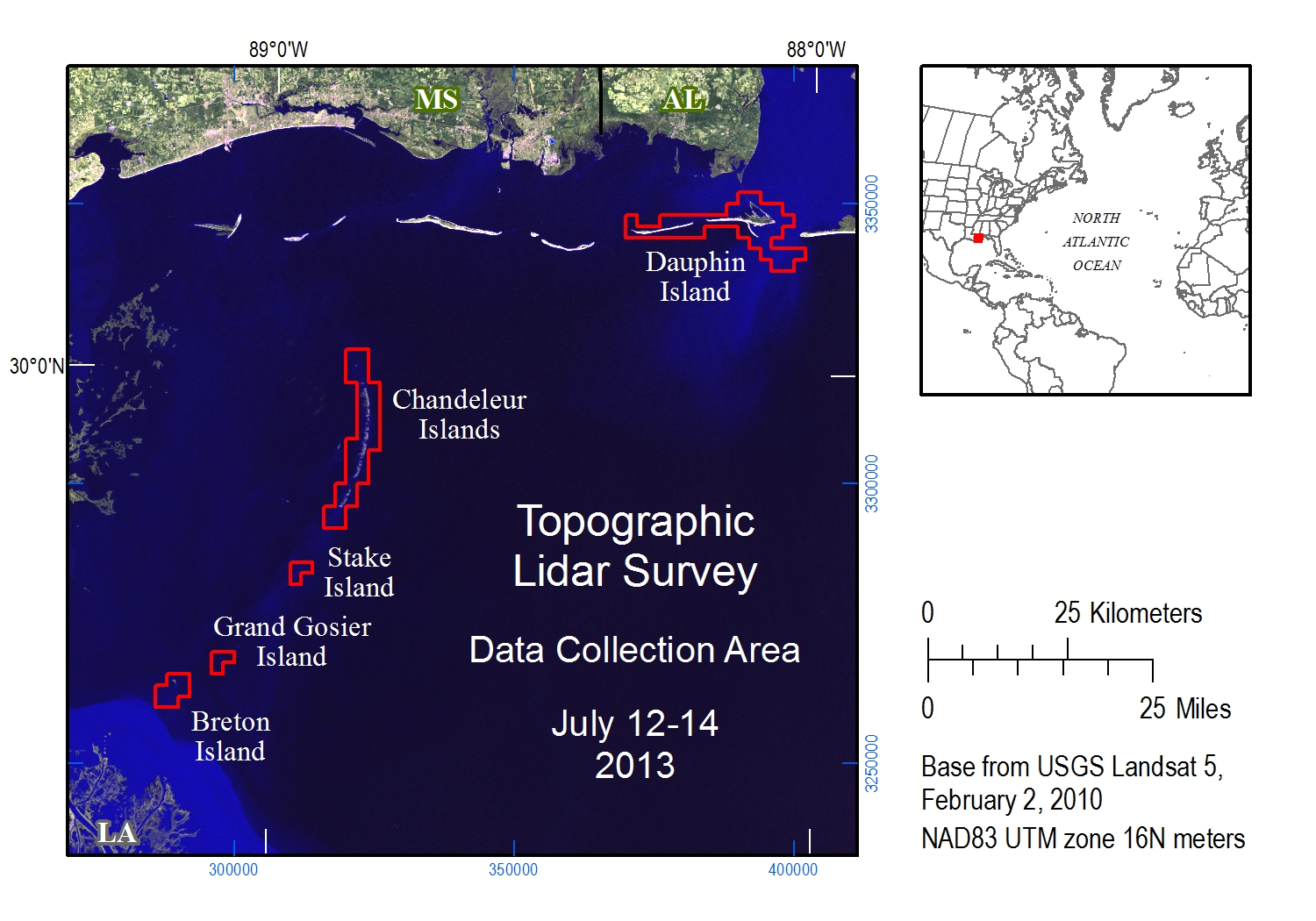
This Data Series Report contains lidar elevation data collected on July 12 and 14, 2013, for Dauphin Island, Alabama, and Chandeleur, Stake, Grand Gosier and Breton Islands, Louisiana. Classified point cloud data—data points described in three dimensions—in lidar data exchange format (LAS) and bare earth digital elevation models (DEMs) in ERDAS Imagine raster format (IMG) are available as downloadable files. Photo Science, Inc., was contracted by the U.S. Geological Survey (USGS) to collect and process these data.
The lidar data were acquired at a horizontal spacing (or nominal pulse spacing) of 1 meter (m) or less. The USGS surveyed points within the project area from July 14–23, 2013, for use in ground control and accuracy assessment. Photo Science, Inc., calculated a vertical root mean square error (RMSEz) of 0.012 m by comparing 10 surveyed points to an interpolated elevation surface of unclassified lidar data. The USGS also checked the data using 80 surveyed points and unclassified lidar point elevation data and found an RMSEz of 0.073 m. The project specified an RMSEz of 0.0925 m or less.
The lidar survey was acquired to document the short- and long-term changes of several different barrier island systems. Specifically, this survey supports detailed studies of Chandeleur and Dauphin Islands that resolve annual changes in beaches, berms and dunes associated with processes driven by storms, sea-level rise, and even human restoration activities.
These lidar data are available to Federal, State and local governments, emergency-response officials, resource managers, and the general public.
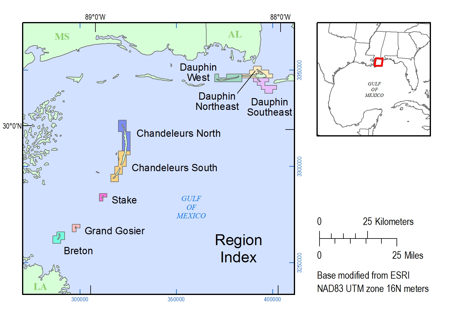
The bare earth DEMs and classified LAS files are organized by 2 kilometer (km) square areas called tiles. The Tile Index shapefile and maps locate the tiles by their filename.
The DEM and LAS metadata files apply to all the tiles.
The bare earth DEMs and classified LAS tiles can be downloaded by region or individually from file directories. The DEM files are 32-bit floating point, 1-m horizontal resolution IMG files. The LAS files are version 1.2. The DEM and LAS files are provided in meters, North American Datum 1983, Universal Transverse Mercator zone 16 North, North American Vertical Datum 1988, geoid 2012A (NAD83, UTM zone 16N, NAVD88, GEOID12A). Vertical datum transformation can be made using VDatum. LAZ files (LASzipped LAS files) can be unzipped using LASzip.
| DEM tiles by region | LAS tiles by region |
|---|---|
| Dauphin West (56 MB) Dauphin Northeast (120 MB) Dauphin Southeast (71 MB) Chandeleurs North (95 MB) Chandeleurs South (87 MB) Breton (17 MB) Grand Gosier (5 MB) Stake (7 MB) |
Dauphin West(117 MB) Dauphin Northeast (24 MB) Dauphin Southeast (92 MB) Chandeleurs North (181 MB) Chandeleurs South (190 MB) Breton (38 MB) Grand Gosier (9 MB) Stake (10 MB) |
| DEM individual tile directories | LAZ individual tile directories |
|---|---|
| Dauphin Island | |
|
Dauphin West Dauphin Northeast Dauphin Southeast |
Dauphin West Dauphin Northeast Dauphin Southeast |
| Chandeleur Islands | |
|
Chandeleurs North Chandeleurs South |
Chandeleurs North Chandeleurs South |
| Breton, Grand Gosier and Stake Islands | |
|
Breton Grand Gosier Stake |
Breton Grand Gosier Stake |
The USGS National Assessment of Coastal Change Hazards project thanks Emily Klipp from the USGS St. Petersburg Coastal and Marine Science Center (SPCMSC) for planning and data management; Julie Bernier for ground-truth analysis (SPCMSC); B.J. Reynolds, Nancy Dewitt and Joe Long for field work support (SPCMSC); Tim Saultz and Patrick Emmett from the USGS National Geospatial Technical Operations Center for lidar contracting; Michael Shillenn at Photo Science, Inc., for data acquisition and post-processing.
Guy, K.K., and Plant, N.G., 2014, Topographic lidar survey of Dauphin Island, Alabama and Chandeleur, Stake, Grand Gosier and Breton Islands, Louisiana, July 12–14, 2013: U.S. Geological Survey Data Series 838, 1 p., https://dx.doi.org/10.3133/ds838.
ISSN 2327–638X (online)

![]() U.S. Department of the Interior |
U.S. Geological Survey
U.S. Department of the Interior |
U.S. Geological Survey
URL: http://pubsdata.usgs.gov/pubs/ds/0838/ds838title.html
Page Contact Information: GS Pubs Web Contact
Page Last Modified: Monday, 28-Nov-2016 19:28:33 EST
