Data Series 888
|
|
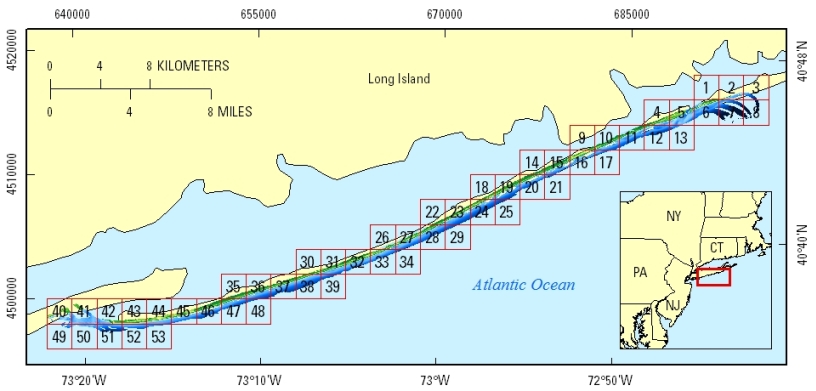
EAARL-B Coastal Topography—Fire Island, New York, Pre-Hurricane Sandy, 2012: Seamless (Bare Earth and Submerged)C. Wayne Wright,1 Christine J. Kranenburg,2 Emily S. Klipp,2 Rodolfo J. Troche,1 Xan Fredericks,2 Melanie L. Masessa,2 and David B. Nagle1 1U.S. Geological Survey; 2Cherokee Nation Technology Solutions This data series report contains lidar-derived seamless (bare-earth and submerged) topography GIS datasets for part of Fire Island, New York, acquired pre-Hurricane Sandy on October 27, 2012. Click on a tile number (1–53) to view the corresponding images and links to each data directory.
Click on the link below to access the shapefile directory of the 2-km by 2-km tile extents displayed above. Suggested Citation: Wright, C.W., Kranenburg, C.J., Klipp, E.S., Troche, R.J., Fredericks, Xan, Masessa, M.L., and Nagle, D.B., 2014, EAARL-B coastal topography—Fire Island, New York, pre-Hurricane Sandy, 2012; seamless (bare earth and submerged): U.S. Geological Survey Data Series 888, https://dx.doi.org/10.3133/ds888. Publications are available from USGS Information Services, Box 25286, Federal Center, Denver, CO 80225-0046 (telephone: 1-888-ASK-USGS; email: infoservices@usgs.gov). |

![]() U.S. Department of the Interior |
U.S. Geological Survey
U.S. Department of the Interior |
U.S. Geological Survey
URL: http://pubsdata.usgs.gov/pubs/ds/0888/html/home.html
Page Contact Information: GS Pubs Web Contact
Page Last Modified: Monday, 28-Nov-2016 20:29:11 EST