Data Series 900
AbstractThe U.S. Geological Survey (USGS) in cooperation with the Harris-Galveston Subsidence District, City of Houston, Fort Bend Subsidence District, Lone Star Groundwater Conservation District, and Brazoria County Groundwater Conservation District has produced an annual series of reports that depict water-level changes in the Chicot, Evangeline, and Jasper aquifers of the Gulf Coast aquifer system in the Houston-Galveston region, Texas, from 1977 to 2013. Changes are determined from water-level measurements between December and March of each year from groundwater wells screened in one of the three aquifers. Existing published maps and unpublished geographic information system (GIS) datasets were compiled into a comprehensive geodatabase of all water-level-change maps produced as part of this multiagency effort. Annual water-level-change maps were georeferenced and digitized where existing GIS data were unavailable (1979–99). Existing GIS data available for 2000–13 were included in the geodatabase. The compilation contains 121 datasets showing water-level changes for each primary aquifer of the Gulf Coast aquifer system: 56 for the Chicot aquifer (1977; 1979–2013 and 1990; 1993–2013), 56 for the Evangeline aquifer (1977; 1979–2013 and 1990; 1993–2013), and 9 for the Jasper aquifer (2000; 2005–13).
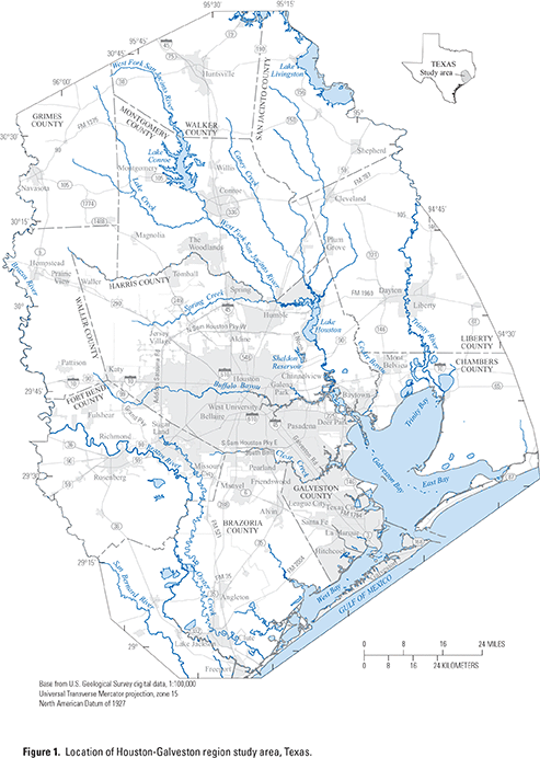
IntroductionContours of changes in water-level altitudes have been produced each year since 1979 for the Houston-Galveston region, Texas—an area consisting of Harris, Galveston, Fort Bend, Montgomery, and Brazoria Counties and adjacent parts of Waller, Grimes, Walker, San Jacinto, Liberty, and Chambers Counties (fig. 1). Contours of changes in water-level altitudes from 1979 through 2013 have been published in an annual series of U.S. Geological Survey (USGS) reports (table 1); these changes are determined from water-level measurements obtained between December and March of each year from groundwater wells screened in one of the three aquifers (Chicot, Evangeline, and Jasper) in the Houston-Galveston region. These contours depicting long-term change are used by groundwater resource managers in the region to better understand water-level changes in the aquifers and how those changes relate to land-surface subsidence. This report, prepared by the USGS in cooperation with the Harris-Galveston Subsidence District, City of Houston, Fort Bend Subsidence District, Lone Star Groundwater Conservation District, and Brazoria County Groundwater Conservation District, provides the geographic information system (GIS) datasets from previously published USGS reports compiled into a comprehensive geodatabase for the three aquifers of the Gulf Coast aquifer system in the Houston-Galveston region from 1979 to 2013.
Purpose and ScopeBy using information from previously published USGS reports, this report documents geospatial changes in water-level altitudes in a geodatabase for the Chicot, Evangeline, and Jasper aquifers of the Gulf Coast aquifer system in the Houston-Galveston region for 121 datasets: 56 for the Chicot aquifer (1977; 1979–2013 and 1990; 1993–2013), 56 for the Evangeline aquifer (1977; 1979–2013 and 1990; 1993–2013), and 9 for the Jasper aquifer (2000; 2005–13). The accompanying geospatial datasets (geodatabase) are a compilation of the published annual report series depicting water-level changes in the Chicot, Evangeline, and Jasper aquifers. The geospatial information in the geodatabase pertains to groundwater-level changes in Harris, Galveston, Fort Bend, Montgomery, and Brazoria Counties from 1977 to 2013. MethodsThe methods for water-level measurement and mapping are briefly described in this section, followed by more detailed discussions on the methods for interpolating water-level change and how those methods changed over time. An overview of the compilation of historical water-level-change data is also included. Water-Level Measurement and MappingWater-level data were obtained by calibrated steel tape, air line, or electric water-level tape or from reported data by company well operators (Kasmarek and others, 2013). These data were reviewed for accuracy and archived in the USGS National Water Information System (http://waterdata.usgs.gov/tx/nwis/nwis). The water-level data were used to create contours of equal water-level change with intervals of typically 10 or 20 feet; these intervals were doubled in some areas where contours were tightly spaced. The mapped extent of the Houston-Galveston region and the aquifers from which water-level data were obtained have both changed over time. Kasmarek and others (2013, p. 2) provides the following overview of the history of water-level altitudes in the study area and the annual USGS reports on those water-level changes, the areas they encompassed, and the aquifers from which data were obtained:
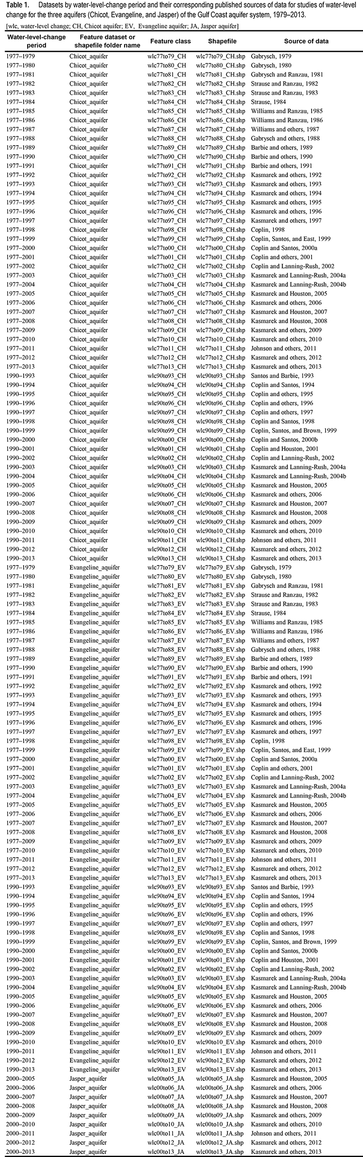
Water-Level Change Interpolation MethodsThe methods for interpolating water-level change were modified throughout the period of study. The method for each set of water-level-change contours created from 1979 through 1994 was manual interpolation of the differences between the beginning year (1977 or 1990, depending on location) and the current year plotted at the well locations on Mylar base maps. Beginning in 1994, GIS methods supplanted manual interpolation as the primary method used to interpolate the water-level-change contours; GIS methods were implemented by using Esri GIS software and different tools that are part of that software (Esri, 1998, 2009, 2011a, 2011b, 2011c, 2011d, 2011e, 2011f, 2012a, 2012b, 2014). For the years 1994 through 2001, the differences computed at each well location were used to interpolate raster surfaces of water-level change by using the GIS command Topogridtool (Hutchinson, 1988, 1989; Esri, 2009). Contours of water-level change were created from the raster surfaces with the GIS Contour tool (Esri, 2009) and then edited and reshaped manually within the GIS environment (ArcEdit) (Esri, 2009). From 2002 to 2008, the water-level-change contours were created by mathematically subtracting a raster surface of the beginning year’s (1977, 1990, or 2000) water-level-altitude map from a raster surface of the current year’s water-level-altitude map and then contouring the resulting raster surface. First, the water-level-altitude maps were interpolated to raster surfaces by using the GIS command Topogridtool (Esri, 2009). Next, the current year’s raster surface was subtracted from the beginning year’s raster surface to produce a water-level-change raster by using GIS tools ArcGrid Operator, Minus (Esri, 2009, 2012a), or Raster Calculator (Esri, 2011c). Finally, the contours were created from the change rasters by using the Contour tool (Esri, 2011a). These contours were then edited and reshaped manually within the GIS environment (ArcEdit) (Esri, 2009).The interpolation methods for the water-level-change contours from 2009 to 2013 followed the same basic procedure as for the years 1994 through 2001; however, the procedure was modified to incorporate additional difference values for locations where the current year’s measurement had no corresponding measurement in the beginning year (1977, 1990, and 2000). The method used for creating the 1977–2009 water-level change is used as an example here (Kasmarek and others, 2009): In addition to the set of wells measured both in 2009 and in 1977, a set of difference values was estimated by using water-level altitudes at locations measured in 2009 extracted from an interpolated raster surface for 1977 (Gabrysch, 1979, sheet 1) (rather than actual measured values) because many of the wells measured in 1977 had been destroyed or were not measured in 2009. The GIS tools Gridspot or Extract Values to Points (Esri, 1998, 2011b) were used to assign values extracted from the interpolated raster surface to the measured wells. The water-level-change values computed by using the raster surface for 1977 were only used when a 2009 measurement lacked a corresponding 1977 measurement; the 1977 water-level altitude and gridded-surface values were equal for the majority of points, and those that were not equal generally differed little. Each set of water-level-change points was interpolated to raster by using the GIS command Topogridtool or GIS tool Topo to Raster (both based on ANUDEM gridding procedure) (Esri, 2009, 2011e; Hutchinson, 1988, 1989, 1996; Hutchinson and Gallant, 2000; Hutchinson and others, 2011). The contours were created from the water-level-change rasters by using the GIS Contour tool (Esri, 2011a). These contours were then edited and reshaped manually within the GIS environment (Esri, 2009, 2011d, 2011f). Historical Water-Level-Change CompilationDatasets by water-level-change period and their corresponding published sources of data are listed in table 1. Scanned images of the maps were obtained for each year of water-level-change data with no existing GIS data (1979–1999). These images were georeferenced to latitude and longitude tick marks and vector data of roads and political boundaries in the projection Universal Transverse Mercator (UTM) zone 15, units of meters, datum North American Datum of 1927 (NAD 27), with root-mean-square (RMS) errors ranging from 46.8 to 173.1. The larger RMS errors, 107.4 to 173.1, coincide with hand-drawn base maps for the years 1979–1991 and may be a result of possible errors such as irregular spacing of tic marks and differences in linear features published in the maps used for georeferencing. The contours were digitized, and change attributes were populated in geodatabase compilations of the comprehensive datasets. The feature classes were organized into three feature datasets by principal aquifer: Chicot, Evangeline, and Jasper aquifers. The geospatial compilations of water-level-change contours are provided in geodatabase and shapefile formats and are accompanied by Federal Geographic Data Committee compliant metadata. DisclaimerThis database, identified as Data Series 900, has been approved for release and publication by the Director of the USGS. Although this database has been subjected to rigorous review and is substantially complete, the USGS reserves the right to revise the data pursuant to further analysis and review. Furthermore, it is released on condition that neither the USGS nor the United States Government may be held liable for any damages resulting from its authorized or unauthorized use. References CitedBarbie, D.L., Coplin, L.S., and Bonnet, C.W., 1989, Approximate water-level changes in wells completed in the Chicot and Evangeline aquifers, 1977–89 and 1988–89, and measured compaction, 1973–1989, in the Houston-Galveston region, Texas: U.S. Geological Survey Open-File Report 89–057, 7 sheets, accessed October 7, 2014, at http://pubs.er.usgs.gov/publication/ofr8957/. Barbie, D.L., Coplin, L.S., and Lock, G.L., 1990, Approximate water-level changes in wells completed in the Chicot and Evangeline aquifers, 1977–90 and 1989–90, and measured compaction, 1973–December 1989, in the Houston-Galveston region, Texas: U.S. Geological Survey Open-File Report 90–132, 7 sheets, accessed October 7, 2014, at http://pubs.er.usgs.gov/publication/ofr90132. Barbie, D.L., Kasmarek, M.C., and Campodonico, Al, 1991, Approximate water-level changes in wells completed in the Chicot and Evangeline aquifers, 1977–91 and 1990–91, and measured compaction, 1973–90, in the Houston-Galveston region, Texas: U.S. Geological Survey Open-File Report 91–094, 7 sheets, accessed October 7, 2014, at http://pubs.er.usgs.gov/publication/ofr9194/. Coplin, L.S., 1998, Water-level altitudes 1998, water-level changes 1977–98 and 1997–98, and measured compaction, 1973–97, in the Chicot and Evangeline aquifers, Houston-Galveston region, Texas: U.S. Geological Survey Open-File Report 98–096, 8 sheets, accessed October 7, 2014, at http://pubs.er.usgs.gov/publication/ofr9896/. Coplin, L.S., and Houston, N.A., 2001, Water-level altitudes 2001 and water-level changes 1990–2001 and 2000–2001 in the Chicot and Evangeline aquifers, Fort Bend County and adjacent areas, Texas: U.S. Geological Survey Open-File Report 2001–093, 6 sheets, accessed October 7, 2014, at http://pubs.er.usgs.gov/publication/ofr0193/. Coplin, L.S., Houston, N.A., and Brown, D.W., 2001, Water-level altitudes 2001, water-level changes 1977–2001 and 2000–2001, and compaction 1973–2000 in the Chicot and Evangeline aquifers, Houston-Galveston region, Texas: U.S. Geological Survey Open-File Report 01–094, 8 sheets, accessed October 7, 2014, at http://pubs.er.usgs.gov/publication/ofr0194/. Coplin, L.S., Kasmarek, M.C., Santos, H.X., and Noble, J.E., 1995, Water-level altitudes 1995 and water-level changes 1990–95 and 1994–95 in the Chicot and Evangeline aquifers, Fort Bend County and adjacent areas, Texas: U.S. Geological Survey Open-File Report 95–183, 6 sheets, accessed October 7, 2014, at http://pubs.er.usgs.gov/publication/ofr95183/. Coplin, L.S., Kasmarek, M.C., Santos, H.X., and Noble, J.E., 1996, Water-level altitudes 1996 and water-level changes 1990–96 and 1995–96 in the Chicot and Evangeline aquifers, Fort Bend County and adjacent areas, Texas: U.S. Geological Survey Open-File Report 96–164, 6 sheets, accessed October 7, 2014, at http://pubs.er.usgs.gov/publication/ofr96164/. Coplin, L.S., Kasmarek, M.C., Santos, H.X., and Sneck-Fahrer, D.A., 1997, Water-level altitudes 1997 and water-level changes 1990–97 and 1996–97 in the Chicot and Evangeline aquifers, Fort Bend County and adjacent areas, Texas: U.S. Geological Survey Open-File Report 97–180, 6 sheets, accessed October 7, 2014, at http://pubs.er.usgs.gov/publication/ofr97180/. Coplin, L.S., and Lanning-Rush, Jennifer, 2002, Water-level altitudes 2002 and water-level changes in the Chicot, Evangeline, and Jasper aquifers and compaction 1973–2001 in the Chicot and Evangeline aquifers, Houston-Galveston region, Texas: U.S. Geological Survey Open-File Report 2002–134, 15 sheets, accessed October 7, 2014, at http://pubs.er.usgs.gov/publication/ofr02134/. Coplin, L.S., and Santos, H.X., 1994, Approximate changes in water levels in wells completed in the Chicot and Evangeline aquifers, 1990–94 and 1993–94, in Fort Bend County and adjacent areas, Texas: U.S. Geological Survey Open-File Report 94–345, 4 sheets, accessed October 7, 2014, at http://pubs.er.usgs.gov/publication/ofr94345/. Coplin, L.S., and Santos, H.X., 1998, Water-level altitudes 1998 and water-level changes 1990–1998 and 1997–98 in the Chicot and Evangeline aquifers, Fort Bend County and adjacent areas, Texas: U.S. Geological Survey Open-File Report 98–095, 6 sheets, accessed October 7, 2014, at http://pubs.er.usgs.gov/publication/ofr9895/. Coplin, L.S., and Santos, H.X., 2000a, Water-level altitudes 2000, water-level changes 1977–2000 and 1999–2000, and compaction 1973–98 in the Chicot and Evangeline aquifers, Houston-Galveston region, Texas: U.S. Geological Survey Open-File Report 2000–094, 8 sheets, accessed October 7, 2014, at http://pubs.er.usgs.gov/publication/ofr0094/. Coplin, L.S., and Santos, H.X., 2000b, Water-level altitudes 2000 and water-level changes 1990–2000 and 1999–2000 in the Chicot and Evangeline aquifers, Fort Bend County and adjacent areas, Texas: U.S. Geological Survey Open-File Report 2000–093, 6 sheets, accessed October 7, 2014, at http://pubs.er.usgs.gov/publication/ofr0093/. Coplin, L.S., Santos, H.X., and Brown, D.W., 1999, Water-level altitudes 1999 and water level changes 1990–99 and 1998–99 in the Chicot and Evangeline aquifers, Fort Bend County and adjacent areas, Texas: U.S. Geological Survey Open-File Report 99–177, 6 sheets, accessed October 7, 2014, at http://pubs.er.usgs.gov/publication/ofr99177. Coplin, L.S., Santos, H.X., and East, J.W., 1999, Water-level altitudes 1999, water-level changes 1977–99 and 1998–99, and measured compaction, 1973–98, in the Chicot and Evangeline aquifers, Houston-Galveston region, Texas: U.S. Geological Survey Open-File Report 99–178, 8 sheets, accessed October 7, 2014, at http://pubs.er.usgs.gov/publication/ofr99178/. Esri, 1998, Gridspot.aml: Accessed October 30, 2014, at http://arcscripts.esri.com/details.asp?dbid=10959/. Esri, 2009, ArcGIS resources—ArcInfo workstation to ArcGIS desktop command glossaries: Accessed October 30, 2014, at http://blogs.esri.com/esri/arcgis/2009/07/11/arcinfo-workstation-to-arcgis-desktop-command-glossaries/. Esri, 2011a, ArcGIS 10.0 help—Contour (Spatial Analyst): Accessed October 21, 2014, at http://help.arcgis.com/en/arcgisdesktop/10.0/help/#//009z000000ts000000.htm/. Esri, 2011b, ArcGIS 10.0 help—Extract Values to Points (Spatial Analyst): Accessed October 28, 2014, at http://help.arcgis.com/en/arcgisdesktop/10.0/help/#//009z0000002t000000.htm/. Esri, 2011c, ArcGIS 10.0 help—Raster Calculator (Spatial Analyst): Accessed October 28, 2014, at http://help.arcgis.com/en/arcgisdesktop/10.0/help/#//009z000000z7000000.htm/. Esri, 2011d, ArcGIS 10.0 help—Reshaping a line: Accessed October 28, 2014, at http://help.arcgis.com/en/arcgisdesktop/10.0/help/#/Reshaping_a_line/001t0000002t000000/. Esri, 2011e, ArcGIS 10.0 help—Topo to Raster (Spatial Analyst): Accessed October 21, 2014, at http://help.arcgis.com/en/arcgisdesktop/10.0/help/#//009z0000006s000000.htm/. Esri, 2011f, ArcGIS 10.0 help—Fundamentals of editing: Accessed October 28, 2014, at http://help.arcgis.com/en/arcgisdesktop/10.0/help/#/What_is_editing/001t00000001000000/. Esri, 2012a, Map algebra precedence for operators: Accessed October 28, 2014, at http://webhelp.esri.com/arcgisdesktop/9.3/index.cfm?TopicName=Map%20Algebra%20precedence%20for%20operators/. Esri, 2012b, Using the Topo to Raster tool: Accessed October 28, 2014, at http://webhelp.esri.com/arcgisdesktop/9.3/index.cfm?TopicName=using%20the%20topo%20to%20raster%20tool/. Esri, 2014, ArcGIS—Mapping and spatial analysis for understanding our world: Redlands, Calif., Esri, accessed January 21, 2014, at http://www.esri.com/software/arcgis/. Gabrysch, R.K., 1979, Approximate water-level changes in wells in the Chicot and Evangeline aquifers, 1977–1979, and measured compaction, 1973–1979, in Harris and Galveston Counties, Texas, U.S. Geological Survey Open-File Report 79–693, 5 sheets, accessed October 7, 2014, at http://pubs.er.usgs.gov/publication/ofr79693/. Gabrysch, R.K., 1980, Approximate water-level changes in wells in the Chicot and Evangeline aquifers in the Houston-Galveston region, Texas, 1977–80 and 1979–1980: U.S. Geological Survey Open-File Report 80–337, 5 sheets, accessed October 7, 2014, at http://pubs.er.usgs.gov/publication/ofr80337/. Gabrysch, R.K., and Ranzau, C.E., 1981, Approximate water-level changes in wells in the Chicot and Evangeline aquifers, 1977–81 and 1980–81, and measured compaction, 1973–1981, in the Houston-Galveston region, Texas: U.S. Geological Survey Open-File Report 81–341, 6 sheets, accessed October 7, 2014, at http://pubs.er.usgs.gov/publication/ofr81341/. Gabrysch, R.K., Ranzau, C.E., Jr., and Coplin, L.S., 1988, Approximate changes in water levels in wells in the Chicot and Evangeline aquifers, 1977–88 and 1987–88, and measured compaction, 1973–1988, in the Houston-Galveston region, Texas: U.S. Geological Survey Open-File Report 88–168, 7 sheets, accessed October 7, 2014, at http://pubs.er.usgs.gov/publication/ofr88168/. Hutchinson, M.F., 1988, Calculation of hydrologically sound digital elevation models—Third International Symposium on Spatial Data Handling, Sydney, Australia, 1988, Proceedings: Columbus, Ohio, The Ohio State University, 421 p. Hutchinson, M.F., 1989, A new procedure for gridding elevation and stream line data with automatic removal of spurious pits: Journal of Hydrology, v. 106, p. 211–232. Hutchinson, M.F., 1996, A locally adaptive approach to the interpolation of digital elevation models, in Proceedings, Third International Conference/Workshop on Integrating GIS and Environmental Modeling: Santa Barbara, Calif., National Center for Geographic Information and Analysis, accessed November 12, 2014, at http://www.ncgia.ucsb.edu/conf/SANTA_FE_CD-ROM/sf_papers/hutchinson_michael_dem/local.html. Hutchinson, M.F., and Gallant, J.C., 2000, Digital elevation models and representation of terrain shape, in Wilson, J.P., and Gallant, J.C., eds., Terrain analysis: New York, Wiley, p. 29–50. Hutchinson, M.F., Xu, T., and Stein, J.A., 2011, Recent progress in the ANUDEM elevation gridding procedure, in Hengel, T., Evans, I.S., Wilson, J.P., and Gould, M., eds., Geomorphometry: Redlands, Calif., p. 19–22, accessed January 2014 at http://geomorphometry.org/HutchinsonXu2011. Johnson, M.R., Ramage, J.K., and Kasmarek, M.C., 2011, Water-level altitudes 2011 and water-level changes in the Chicot, Evangeline, and Jasper aquifers and compaction 1973–2010 in the Chicot and Evangeline aquifers, Houston-Galveston region, Texas: U.S. Geological Survey Scientific Investigations Map 3174, 17 p., 16 sheets, accessed October 7, 2014, at http://pubs.er.usgs.gov/publication/sim3174/. Kasmarek, M.C., 1997, Water-level altitudes in wells completed in the Chicot and Evangeline aquifers, Fort Bend County and adjacent areas, Texas, January–February 1990: U.S. Geological Survey Open-File Report 97–784, 2 sheets. Kasmarek, M.C., Barbie, D.L., and Campodonico, Al, 1992, Approximate changes in water levels in wells completed in the Chicot and Evangeline aquifers, 1977–92 and 1991–92, and measured compaction, 1973–91, in the Houston-Galveston region, Texas: U.S. Geological Survey Open-File Report 92–066, 7 sheets, accessed October 7, 2014, at http://pubs.er.usgs.gov/publication/ofr9266/. Kasmarek, M.C., Coplin, L.S., and Campodonico, Al, 1993, Approximate changes in water levels in wells completed in the Chicot and Evangeline aquifers, 1977–93 and 1992–93, and measured compaction, 1973–92, in the Houston-Galveston region, Texas: U.S. Geological Survey Open-File Report 93–086, 7 sheets, accessed October 7, 2014, at http://pubs.er.usgs.gov/publication/ofr9386/. Kasmarek, M.C., Coplin, L.S., and Santos, H.X., 1994, Approximate changes in water levels in wells completed in the Chicot and Evangeline aquifers, 1977–94 and 1993–94, and measured compaction, 1973–93, in the Houston-Galveston region, Texas: U.S. Geological Survey Open-File Report 94–346, 6 sheets, accessed October 7, 2014, at http://pubs.er.usgs.gov/publication/ofr94346/. Kasmarek, M.C., Coplin, L.S., and Santos, H.X., 1995, Water-level altitudes 1995, water-level changes 1977–95 and 1994–95, and measured compaction, 1973–94, in the Chicot and Evangeline aquifers, Houston-Galveston region, Texas: U.S. Geological Survey Open-File Report 95–182, 8 sheets, accessed October 7, 2014, at http://pubs.er.usgs.gov/publication/ofr95182/. Kasmarek, M.C., Coplin, L.S., and Santos, H.X., 1996, Water-level altitudes 1996, water-level changes 1977–96 and 1995–96, and measured compaction, 1973–95, in the Chicot and Evangeline aquifers, Houston-Galveston region, Texas: U.S. Geological Survey Open-File Report 96–163, 8 sheets, accessed October 7, 2014, at http://pubs.er.usgs.gov/publication/ofr96163/. Kasmarek, M.C., Coplin, L.S., and Santos, H.X., 1997, Water-level altitudes 1997, water-level changes 1977–97 and 1996–97, and measured compaction, 1973–96, in the Chicot and Evangeline aquifers, Houston-Galveston region, Texas: U.S. Geological Survey Open-File Report 97–181, 8 sheets, accessed October 7, 2014, at http://pubs.er.usgs.gov/publication/ofr97181/. Kasmarek, M.C., and Houston, N.A., 2005, Water-level altitudes 2005 and water-level changes in the Chicot, Evangeline, and Jasper aquifers and compaction 1973–2004 in the Chicot and Evangeline aquifers, Houston-Galveston region, Texas: U.S. Geological Survey Open-File Report 2005–1128, 17 sheets, accessed October 7, 2014, at http://pubs.er.usgs.gov/publication/ofr20051128/. Kasmarek, M.C., and Houston, N.A., 2007, Water-level altitudes 2007 and water-level changes in the Chicot, Evangeline, and Jasper aquifers and compaction 1973–2006 in the Chicot and Evangeline aquifers, Houston-Galveston region, Texas: U.S. Geological Survey Scientific Investigations Map 2968, 159 p., 18 sheets, accessed October 7, 2014, at http://pubs.er.usgs.gov/publication/sim2968/. Kasmarek, M.C., and Houston, N.A., 2008, Water-level altitudes 2008 and water-level changes in the Chicot, Evangeline, and Jasper aquifers and compaction 1973–2007 in the Chicot and Evangeline aquifers, Houston-Galveston region, Texas: U.S. Geological Survey Scientific Investigations Map 3031, 4 p., 17 sheets, accessed October 7, 2014, at http://pubs.er.usgs.gov/publication/sim3031/. Kasmarek, M.C., Houston, N.A., and Brown, D.W., 2006, Water-level altitudes 2006 and water-level changes in the Chicot, Evangeline, and Jasper aquifers and compaction 1973–2005 in the Chicot and Evangeline aquifers, Houston-Galveston region, Texas: U.S. Geological Survey Open-File Report 2006–1079, 15 sheets, accessed October 7, 2014, at http://pubs.er.usgs.gov/publication/ofr20061079/. Kasmarek, M.C., Houston, N.A., and Ramage, J.K., 2009, Water-level altitudes 2009 and water-level changes in the Chicot, Evangeline, and Jasper aquifers and compaction 1973–2008 in the Chicot and Evangeline aquifers, Houston-Galveston region, Texas: U.S. Geological Survey Scientific Investigations Map 3081, 3 p., 16 sheets, 2 apps., accessed October 7, 2014, at http://pubs.er.usgs.gov/publication/sim3081/. Kasmarek, M.C., Johnson, M.R., and Ramage, J.K., 2010, Water-level altitudes 2010 and water-level changes in the Chicot, Evangeline, and Jasper aquifers and compaction 1973–2009 in the Chicot and Evangeline aquifers, Houston-Galveston region, Texas: U.S. Geological Survey Scientific Investigations Map 3138, 17 p., 16 sheets, 1 app., accessed October 7, 2014, at http://pubs.er.usgs.gov/publication/sim3138/. Kasmarek, M.C., Johnson, M.R., and Ramage, J.K., 2012, Water-level altitudes 2012 and water-level changes in the Chicot, Evangeline, and Jasper aquifers and compaction 1973–2011 in the Chicot and Evangeline aquifers, Houston-Galveston region, Texas: U.S. Geological Survey Scientific Investigations Map 3230, 18 p., 16 sheets, 1 app., accessed October 7, 2014, at http://pubs.er.usgs.gov/publication/sim3230. Kasmarek, M.C., Johnson, M.R., and Ramage, J.K., 2013, Water-level altitudes 2013 and water-level changes in the Chicot, Evangeline, and Jasper aquifers and compaction 1973–2012 in the Chicot and Evangeline aquifers, Houston-Galveston region, Texas: U.S. Geological Survey Scientific Investigations Map 3263, 19 p., 16 sheets, accessed October 7, 2014, at http://pubs.er.usgs.gov/publication/sim3263/. Kasmarek, M.C., and Lanning-Rush, Jennifer, 2004a, Water-level altitudes 2003 and water-level changes in the Chicot, Evangeline, and Jasper aquifers and compaction 1973–2002 in the Chicot and Evangeline aquifers, Houston-Galveston region, Texas: U.S. Geological Survey Open-File Report 2003–109, 15 sheets, accessed October 7, 2014, at http://pubs.er.usgs.gov/publication/ofr03109/. Kasmarek, M.C., and Lanning-Rush, Jennifer, 2004b, Water-level altitudes 2004 and water-level changes in the Chicot, Evangeline, and Jasper aquifers and compaction 1973–2003 in the Chicot and Evangeline aquifers, Houston-Galveston region, Texas: U.S. Geological Survey Open-File Report 04–1084, 13 sheets, accessed October 7, 2014, at http://pubs.er.usgs.gov/publication/ofr20041084/. Santos, H.X., and Barbie, D.L., 1993, Approximate changes in water levels in wells completed in the Chicot and Evangeline aquifers, 1990–93 and 1992–93, in Fort Bend County and adjacent areas, Texas: U.S. Geological Survey Open-File Report 93–081, 4 sheets, accessed October 7, 2014, at http://pubs.er.usgs.gov/publication/ofr9381/. Strause, J.L., 1984, Approximate water-level changes in wells in the Chicot and Evangeline aquifers, 1977–84 and 1983–84, and measured compaction, 1973–1984, in the Houston-Galveston region, Texas: U.S. Geological Survey Open-File Report 84–140, 6 sheets, accessed October 7, 2014, at http://pubs.er.usgs.gov/publication/ofr84140/. Strause, J.L., and Ranzau, C.E., Jr., 1982, Approximate water-level changes in wells in the Chicot and Evangeline aquifers, 1977–82 and 1981–82, and measured compaction, 1973–1982, in the Houston-Galveston region, Texas: U.S. Geological Survey Open-File Report 82–328, 5 sheets, accessed October 7, 2014, at http://pubs.er.usgs.gov/publication/ofr82328/. Strause, J.L., and Ranzau, C.E., Jr., 1983, Approximate water-level changes in wells in the Chicot and Evangeline aquifers, 1977–83 and 1982–83, and measured compaction, 1973–1983, in Harris and Galveston counties, Texas: U.S. Geological Survey Open-File Report 83–150, 6 sheets, accessed October 7, 2014, at http://pubs.er.usgs.gov/publication/ofr83150/. Williams, J.F., III, and Ranzau, C.E., Jr., 1985, Approximate water-level changes in wells in the Chicot and Evangeline aquifers, 1977–85 and 1984–85, and measured compaction, 1973–1985, in Harris and Galveston counties, Texas: U.S. Geological Survey Open-File Report 85–158, 6 sheets, accessed October 7, 2014, at http://pubs.er.usgs.gov/publication/ofr85158/. Williams, J.F., III, and Ranzau, C.E., Jr., 1986, Approximate change in water levels in wells in the Chicot and Evangeline aquifers, 1977–86 and 1985–86, and measured compaction, 1973–1986, in the Houston-Galveston region, Texas: U.S. Geological Survey Open-File Report 86–135, 7 sheets, accessed October 7, 2014, at http://pubs.er.usgs.gov/publication/ofr86135/. Williams, J.F., III, Ranzau, C.E., Jr., and Lind, W.B., 1987, Approximate water-level changes in wells in the Chicot and Evangeline aquifers, 1977–87 and 1986–87, and measured compaction, 1973–1987, in the Houston-Galveston region, Texas: U.S. Geological Survey Open-File Report 87–108, 7 sheets, accessed October 7, 2014, at http://pubs.er.usgs.gov/publication/ofr87108/. |
First posted December 11, 2014
For additional information, contact: Part or all of this report is presented in Portable Document Format (PDF). For best results viewing and printing PDF documents, it is recommended that you download the documents to your computer and open them with Adobe Reader. PDF documents opened from your browser may not display or print as intended. Download the latest version of Adobe Reader, free of charge. More information about viewing, downloading, and printing report files can be found here. |
||||||||||||||||||||||||||||||||
Johnson, M.R., and Linard, J.I., 2014, Geospatial compilation of historical water-level changes in the Chicot and Evangeline aquifers 1977–2013 and Jasper aquifer 2000–13, Gulf Coast aquifer system, Houston-Galveston region, Texas: U.S. Geological Survey Data Series 900, https://dx.doi.org/10.3133/ds900.
ISSN 2327-638X (online)
Abstract
Introduction
Purpose and Scope
Methods
References Cited

![]() U.S. Department of the Interior |
U.S. Geological Survey
U.S. Department of the Interior |
U.S. Geological Survey
URL: http://pubsdata.usgs.gov/pubs/ds/0900/index.html
Page Contact Information: GS Pubs Web Contact
Page Last Modified: Monday, 28-Nov-2016 20:30:52 EST