Digital Series 170
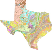
The purpose of this report is to release a digital geologic map database for the State of Texas. This dataset was developed to provide a digital geologic map database of the Barnes 1992 Geologic Map of Texas. This data set was prepared in cooperation with the Texas Bureau of Economic Geology. The Geologic Map of Texas was originally printed as four 1:500,000-scale sheets. Original clear-film positives of these sheets were provided by the Texas Bureau of Economic Geology. These were scanned, georeferenced, digitized and attributed, edge matched, and combined into a single statewide database. There are three digital layers that cover the entire State: formations and contacts, geologic faults, and graphic decorations. The merged layers are still at 1:500,000 scale, and their use at scales significantly different is not recommended. The provided data formats are ESRI ArcInfo coverage interchange .e00 and ESRI shapefile. |
Version 1.1 Posted January 2007 |
Part or all of this report is presented in Portable Document Format (PDF); the latest version of Adobe Acrobat Reader or similar software is required to view it. Download the latest version of Acrobat Reader, free of charge or go to access.adobe.com for free tools that allow visually impaired users to read PDF files.
