GMX_CMP: usSEABED component and features data for the entire U.S. Gulf of Mexico and Caribbean (Puerto Rico and U.S. Virgin Islands)

Metadata also available as - [Outline] - [Parseable text]

Frequently-anticipated questions:


What does this data set describe?

Title:
GMX_CMP: usSEABED component and features data for the entire U.S. Gulf of Mexico and Caribbean (Puerto Rico and U.S. Virgin Islands)
Abstract:
This component data layer (_CMP.txt) file gives information about selected components (minerals, rock type, microfossils, benthic biota) and seafloor features (bioturbation, structure, ripples) at a given site. Values in the attribute fields represent the membership to that attribute's fuzzy set. For components such as minerals, rocks, micro-biota and plants, and/or epifauna and infauna, corals and other geologic and biologic information, the value depends on sentence structure and other components in description. For features (denoted by an asterisk) such as ripples, ophiuroids, sponges, shrimp, worm tubes, lamination, lumps, grading, and/or bioturbation, the value of the fuzzy set depends on the development of the attribute. Only the relative fuzzy presence of components and features can be determined; the absence of information does not indicate a lack of the attribute, only lack of information about that attribute.
Supplemental_Information:
This layer can be used in a relational data base, using the DataSetKey to link to the GMX_SRC.txt file for brief metadata information and to formal metadata written on each source, and to the other data files of usSEABED using the SiteKey or SampleKey as relational links.
  1. How should this data set be cited?

    U.S. Geological Survey, and Colorado, University of , 2006, GMX_CMP: usSEABED component and features data for the entire U.S. Gulf of Mexico and Caribbean (Puerto Rico and U.S. Virgin Islands):.

    Online Links:

    This is part of the following larger work.

    Buczkowski, B.J., Reid, J.A., Jenkins, C.J., Reid, J.M., Williams, S.J., and Flocks, J.G., 2006, usSEABED: Gulf of Mexico and Caribbean (Puerto Rico and U.S. Virgin Islands) Offshore Surficial Sediment Data Release: Data Series 146, U.S. Geological Survey, Coastal and Marine Geology Program, Wooods Hole Science Center, Woods Hole, MA.

    Online Links:

  2. What geographic area does the data set cover?

    West_Bounding_Coordinate: -100.000000
    East_Bounding_Coordinate: -64.000000
    North_Bounding_Coordinate: 32.000000
    South_Bounding_Coordinate: 17.000000

  3. What does it look like?

    <https://pubs.usgs.gov/ds/2006/146/data/gmx_cmp.jpg> (JPEG)
    Image map showing extent of data layer coverage

  4. Does the data set describe conditions during a particular time period?

    Calendar_Date: 2006
    Currentness_Reference: publication date

  5. What is the general form of this data set?

    Geospatial_Data_Presentation_Form: vector digital data

  6. How does the data set represent geographic features?

    1. How are geographic features stored in the data set?

      This is a Vector data set. It contains the following vector data types (SDTS terminology):

      • Point (242164)

    2. What coordinate system is used to represent geographic features?

      Horizontal positions are specified in geographic coordinates, that is, latitude and longitude. Latitudes are given to the nearest 0.00001. Longitudes are given to the nearest 0.00001. Latitude and longitude values are specified in Decimal degrees.

      The horizontal datum used is North American Datum of 1927.
      The ellipsoid used is Clarke 1866.
      The semi-major axis of the ellipsoid used is 6378206.400000.
      The flattening of the ellipsoid used is 1/294.978698.

  7. How does the data set describe geographic features?

    Point
    Sample location (Source: Source reports)

    Nod_F
    Nodule (Source: dbSEABED thesaurus; see table D in the data publication (Larger_Work_Citation) for list of triggering major synonyms)

    Range of values
    Minimum:0
    Maximum:unknown
    Units:unitless
    Resolution:0.1

    FID
    Internal feature number. (Source: ESRI)

    Sequential unique whole numbers that are automatically generated.

    Shape
    Feature geometry. (Source: ESRI)

    Coordinates defining the features.

    LATITUDE

    LONGITUDE

    WATERDEPTH
    Internal feature number. (Source: ESRI)

    Sequential unique whole numbers that are automatically generated.

    SAMPLETOP

    SAMPLEBASE
    Feature geometry. (Source: ESRI)

    Coordinates defining the features.

    SITE

    DATASETKEY

    SITEKEY

    SAMPLEKEY

    SAMPLER

    DATATYPE

    QTZ

    FLD

    MICA

    CLAYMIN

    GLAUC

    HVY_MIN

    MAF

    GBBRO

    BASLT

    ANDEST

    GRANIT

    IGN_RCK

    SCHST

    BLUSCHST

    SLTE

    CHRT

    DOLMT

    LIMSTN

    MUDSTN

    SNDSTN

    PHSPHT

    TRRG

    CARB

    GLACL

    ARTIF_F

    SPOIL_F

    WOOD

    OOL

    PELAG

    FRM

    BNTH_FRM

    PLNK_FRM

    PTR

    NAN

    CALC_OOZ

    SIL_OOZ

    OOZ

    DIAT

    RAD

    ANMNE_F

    CRLRF

    CRL

    CRL_DBR

    SOL_CRL

    SFTCRL_F

    SHL

    SHL_DBR

    BRYZ

    BRACH

    ECHNDRM_F

    ECHND

    ASTERD_F

    OPHIURD_F

    HOLOTH

    SND_DOLLR

    CRINOD_F

    MLSC

    BIV

    GSTRPD

    RZR_CLM

    OYST

    SCLLP

    SCPHPD

    SPNG_F

    CRUSTAC

    SHRMP_F

    CRAB

    BRNCL

    ANNLD_F

    SRPUL

    WRM_F

    WRM_TBE_F

    BIOTURB_F

    BURW_F

    PIT_F

    FCES

    MOTL_F

    CRNALG

    HALMDA

    KLP_F

    PLNT_F

    SEAGRS_F

    SFT_ALG_F

    PEAT

    ORGCBN

    GAS

    ODR

    H2S

    DEFRMN_F

    FLASR_BED_

    GRADD_F

    LAMINTD_F

    LENTICLR_B

    PLANR_BED_

    Latitude
    Latitude coordinate of sample location (Source: Source data)

    location information in decimal degrees

    Longitude
    Longitude coordinate of sample location (Source: Source data)

    location information in decimal degrees

    RIPL

    SCOUR

    SampleTop
    Measured subbottom depth information for each point sample (top) (Source: Source data)

    Subsample location information in meters

    DataSetKey
    Data set key (relational link) (Source: dbSEABED MNEt program)

    Unique sequential numeric key to SRC file

    WVY_BED_F

    LMP_F

    SiteKey
    Site key (relational link) (Source: dbSEABED MNEt program)

    Unique sequential numeric key to information about the same site in other usSEABED data files

    SampleKey
    Sample key (relational link) (Source: Source data)

    Unique sequential numeric key to information about the same sample or subsample in other usSEABED data files

    DataType
    Data type (Source: Source data)

    Source type of data; see table A in the data publication (Larger_Work_Citation).

    NOD_F

    Qtz
    Quartz (Source: dbSEABED thesaurus; see table D in the data publication (Larger_Work_Citation) for list of triggering major synonyms)

    Range of values
    Minimum:0
    Maximum:100
    Units:unitless
    Resolution:0.1

    Fld
    Feldspar (Source: dbSEABED thesaurus; see table D in the data publication (Larger_Work_Citation) for list of triggering major synonyms)

    Range of values
    Minimum:0
    Maximum:100
    Units:unitless
    Resolution:0.1

    Mica
    Micas (Source: dbSEABED thesaurus; see table D in the data publication (Larger_Work_Citation) for list of triggering major synonyms)

    Range of values
    Minimum:0
    Maximum:100
    Units:unitless
    Resolution:0.1

    Claymin
    Clay minerals (Source: dbSEABED thesaurus; see table D in the data publication (Larger_Work_Citation) for list of triggering major synonyms)

    Range of values
    Minimum:0
    Maximum:100
    Units:unitless
    Resolution:0.1

    Glauc
    Glauconite (Source: dbSEABED thesaurus; see table D in the data publication (Larger_Work_Citation) for list of triggering major synonyms)

    Range of values
    Minimum:0
    Maximum:100
    Units:unitless
    Resolution:0.1

    Hvy_min
    Heavy minerals (Source: dbSEABED thesaurus; see table D in the data publication (Larger_Work_Citation) for list of triggering major synonyms)

    Range of values
    Minimum:0
    Maximum:100
    Units:unitless
    Resolution:0.1

    Maf
    Mafics (Source: dbSEABED thesaurus; see table D in the data publication (Larger_Work_Citation) for list of triggering major synonyms)

    Range of values
    Minimum:0
    Maximum:100
    Units:unitless
    Resolution:0.1

    Gbbro
    Gabbro (Source: dbSEABED thesaurus; see table D in the data publication (Larger_Work_Citation) for list of triggering major synonyms)

    Range of values
    Minimum:0
    Maximum:100
    Units:unitless
    Resolution:0.1

    Baslt
    Basalt (Source: dbSEABED thesaurus; see table D in the data publication (Larger_Work_Citation) for list of triggering major synonyms)

    Range of values
    Minimum:0
    Maximum:100
    Units:unitless
    Resolution:0.1

    Andest
    Andesite (Source: dbSEABED thesaurus; see table D in the data publication (Larger_Work_Citation) for list of triggering major synonyms)

    Range of values
    Minimum:0
    Maximum:100
    Units:unitless
    Resolution:0.1

    Granit
    Granite (Source: dbSEABED thesaurus; see table D in the data publication (Larger_Work_Citation) for list of triggering major synonyms)

    Range of values
    Minimum:0
    Maximum:100
    Units:unitless
    Resolution:0.1

    Ign_rck
    Igneous rock (Source: dbSEABED thesaurus; see table D in the data publication (Larger_Work_Citation) for list of triggering major synonyms)

    Range of values
    Minimum:0
    Maximum:100
    Units:unitless
    Resolution:0.1

    Schst
    Schist (Source: dbSEABED thesaurus; see table D in the data publication (Larger_Work_Citation) for list of triggering major synonyms)

    Range of values
    Minimum:0
    Maximum:100
    Units:unitless
    Resolution:0.1

    Bluschst
    Blueschist (Source: dbSEABED thesaurus; see table D in the data publication (Larger_Work_Citation) for list of triggering major synonyms)

    Range of values
    Minimum:0
    Maximum:100
    Units:unitless
    Resolution:0.1

    Slte
    Low grade metamorphics (Source: dbSEABED thesaurus; see table D in the data publication (Larger_Work_Citation) for list of triggering major synonyms)

    Range of values
    Minimum:0
    Maximum:100
    Units:unitless
    Resolution:0.1

    Chrt
    Chert (Source: dbSEABED thesaurus; see table D in the data publication (Larger_Work_Citation) for list of triggering major synonyms)

    Range of values
    Minimum:0
    Maximum:100
    Units:unitless
    Resolution:0.1

    Dolmt
    Dolomite (Source: dbSEABED thesaurus; see table D in the data publication (Larger_Work_Citation) for list of triggering major synonyms)

    Range of values
    Minimum:0
    Maximum:100
    Units:unitless
    Resolution:0.1

    Limstn
    Limestone (Source: dbSEABED thesaurus; see table D in the data publication (Larger_Work_Citation) for list of triggering major synonyms)

    Range of values
    Minimum:0
    Maximum:100
    Units:unitless
    Resolution:0.1

    Mudstn
    Mudstone (Source: dbSEABED thesaurus; see table D in the data publication (Larger_Work_Citation) for list of triggering major synonyms)

    Range of values
    Minimum:0
    Maximum:100
    Units:unitless
    Resolution:0.1

    Sndstn
    Sandstone (Source: dbSEABED thesaurus; see table D in the data publication (Larger_Work_Citation) for list of triggering major synonyms)

    Range of values
    Minimum:0
    Maximum:100
    Units:unitless
    Resolution:0.1

    Phspht
    Phosphate/phosphorite (Source: dbSEABED thesaurus; see table D in the data publication (Larger_Work_Citation) for list of triggering major synonyms)

    Range of values
    Minimum:0
    Maximum:100
    Units:unitless
    Resolution:0.1

    Trrg
    Terrigenous (Source: dbSEABED thesaurus; see table D in the data publication (Larger_Work_Citation) for list of triggering major synonyms)

    Range of values
    Minimum:0
    Maximum:100
    Units:unitless
    Resolution:0.1

    Carb
    Carbonate/calcareous (Source: dbSEABED thesaurus; see table D in the data publication (Larger_Work_Citation) for list of triggering major synonyms)

    Range of values
    Minimum:0
    Maximum:100
    Units:unitless
    Resolution:0.1

    Glacl
    Glacial (Source: dbSEABED thesaurus; see table D in the data publication (Larger_Work_Citation) for list of triggering major synonyms)

    Range of values
    Minimum:0
    Maximum:100
    Units:unitless
    Resolution:0.1

    Artif_F
    Artificial (Source: dbSEABED thesaurus; see table D in the data publication (Larger_Work_Citation) for list of triggering major synonyms)

    Range of values
    Minimum:0
    Maximum:100
    Units:unitless
    Resolution:0.1

    Spoil_F
    Spoil/dredge material (Source: dbSEABED thesaurus; see table D in the data publication (Larger_Work_Citation) for list of triggering major synonyms)

    Range of values
    Minimum:0
    Maximum:100
    Units:unitless
    Resolution:0.1

    Wood
    Wood (Source: dbSEABED thesaurus; see table D in the data publication (Larger_Work_Citation) for list of triggering major synonyms)

    Range of values
    Minimum:0
    Maximum:100
    Units:unitless
    Resolution:0.1

    Ool
    Oolite (Source: dbSEABED thesaurus; see table D in the data publication (Larger_Work_Citation) for list of triggering major synonyms)

    Range of values
    Minimum:0
    Maximum:100
    Units:unitless
    Resolution:0.1

    Pelag
    Pelagic (Source: dbSEABED thesaurus; see table D in the data publication (Larger_Work_Citation) for list of triggering major synonyms)

    Range of values
    Minimum:0
    Maximum:100
    Units:unitless
    Resolution:0.1

    Frm
    Foraminifera (Source: dbSEABED thesaurus; see table D in the data publication (Larger_Work_Citation) for list of triggering major synonyms)

    Range of values
    Minimum:0
    Maximum:100
    Units:unitless
    Resolution:0.1

    Bnth_frm
    Benthic foraminifera (Source: dbSEABED thesaurus; see table D in the data publication (Larger_Work_Citation) for list of triggering major synonyms)

    Range of values
    Minimum:0
    Maximum:100
    Units:unitless
    Resolution:0.1

    Plnk_frm
    Planktonic foraminifera (Source: dbSEABED thesaurus; see table D in the data publication (Larger_Work_Citation) for list of triggering major synonyms)

    Range of values
    Minimum:0
    Maximum:100
    Units:unitless
    Resolution:0.1

    Ptr
    Pteropod (Source: dbSEABED thesaurus; see table D in the data publication (Larger_Work_Citation) for list of triggering major synonyms)

    Range of values
    Minimum:0
    Maximum:100
    Units:unitless
    Resolution:0.1

    Nan
    Nannofossil (Source: dbSEABED thesaurus; see table D in the data publication (Larger_Work_Citation) for list of triggering major synonyms)

    Range of values
    Minimum:0
    Maximum:100
    Units:unitless
    Resolution:0.1

    Calc_ooz
    Calcareous ooze (Source: dbSEABED thesaurus; see table D in the data publication (Larger_Work_Citation) for list of triggering major synonyms)

    Range of values
    Minimum:0
    Maximum:100
    Units:unitless
    Resolution:0.1

    Ooz
    Ooze (Source: dbSEABED thesaurus; see table D in the data publication (Larger_Work_Citation) for list of triggering major synonyms)

    Range of values
    Minimum:0
    Maximum:100
    Units:unitless
    Resolution:0.1

    Sil_ooz
    Siliceous ooze (Source: dbSEABED thesaurus; see table D in the data publication (Larger_Work_Citation) for list of triggering major synonyms)

    Range of values
    Minimum:0
    Maximum:100
    Units:unitless
    Resolution:0.1

    Diat
    Diatom (Source: dbSEABED thesaurus; see table D in the data publication (Larger_Work_Citation) for list of triggering major synonyms)

    Range of values
    Minimum:0
    Maximum:100
    Units:unitless
    Resolution:0.1

    Rad
    Radiolaria (Source: dbSEABED thesaurus; see table D in the data publication (Larger_Work_Citation) for list of triggering major synonyms)

    Range of values
    Minimum:0
    Maximum:100
    Units:unitless
    Resolution:0.1

    Anmne_F
    Sea anemone (Source: dbSEABED thesaurus; see table D in the data publication (Larger_Work_Citation) for list of triggering major synonyms)

    Range of values
    Minimum:0
    Maximum:unknown
    Units:unitless
    Resolution:0.1

    Crlrf
    Coral reef (Source: dbSEABED thesaurus; see table D in the data publication (Larger_Work_Citation) for list of triggering major synonyms)

    Range of values
    Minimum:0
    Maximum:100
    Units:unitless
    Resolution:0.1

    Crl
    Coral (Source: dbSEABED thesaurus; see table D in the data publication (Larger_Work_Citation) for list of triggering major synonyms)

    Range of values
    Minimum:0
    Maximum:100
    Units:unitless
    Resolution:0.1

    Crl_dbr
    Coral debris (Source: dbSEABED thesaurus; see table D in the data publication (Larger_Work_Citation) for list of triggering major synonyms)

    Range of values
    Minimum:0
    Maximum:100
    Units:unitless
    Resolution:0.1

    Sol_crl
    Solitary coral (Source: dbSEABED thesaurus; see table D in the data publication (Larger_Work_Citation) for list of triggering major synonyms)

    Range of values
    Minimum:0
    Maximum:100
    Units:unitless
    Resolution:0.1

    Sftcrl_F
    Soft coral (Source: dbSEABED thesaurus; see table D in the data publication (Larger_Work_Citation) for list of triggering major synonyms)

    Range of values
    Minimum:0
    Maximum:unknown
    Units:unitless
    Resolution:0.1

    Shl
    Shell (Source: dbSEABED thesaurus; see table D in the data publication (Larger_Work_Citation) for list of triggering major synonyms)

    Range of values
    Minimum:0
    Maximum:100
    Units:unitless
    Resolution:0.1

    Shl_dbr
    Shell debris (Source: dbSEABED thesaurus; see table D in the data publication (Larger_Work_Citation) for list of triggering major synonyms)

    Range of values
    Minimum:0
    Maximum:100
    Units:unitless
    Resolution:0.1

    Bryz
    Bryozoa (Source: dbSEABED thesaurus; see table D in the data publication (Larger_Work_Citation) for list of triggering major synonyms)

    Range of values
    Minimum:0
    Maximum:100
    Units:unitless
    Resolution:0.1

    Brach
    Brachiopod (Source: dbSEABED thesaurus; see table D in the data publication (Larger_Work_Citation) for list of triggering major synonyms)

    Range of values
    Minimum:0
    Maximum:100
    Units:unitless
    Resolution:0.1

    Echndrm_F
    Echinoderm (Source: dbSEABED thesaurus; see table D in the data publication (Larger_Work_Citation) for list of triggering major synonyms)

    Range of values
    Minimum:0
    Maximum:unknown
    Units:unitless
    Resolution:0.1

    Echnd
    Echinoid (Source: dbSEABED thesaurus; see table D in the data publication (Larger_Work_Citation) for list of triggering major synonyms)

    Range of values
    Minimum:0
    Maximum:100
    Units:unitless
    Resolution:0.1

    Asterd_F
    Asteroid (Source: dbSEABED thesaurus; see table D in the data publication (Larger_Work_Citation) for list of triggering major synonyms)

    Range of values
    Minimum:0
    Maximum:unknown
    Units:unitless
    Resolution:0.1

    Ophiurd_F
    Ophiuroid (Source: dbSEABED thesaurus; see table D in the data publication (Larger_Work_Citation) for list of triggering major synonyms)

    Range of values
    Minimum:0
    Maximum:unknown
    Units:unitless
    Resolution:0.1

    Holoth
    Holothurian (Source: dbSEABED thesaurus; see table D in the data publication (Larger_Work_Citation) for list of triggering major synonyms)

    Range of values
    Minimum:0
    Maximum:100
    Units:unitless
    Resolution:0.1

    Crinod_F
    Crinoid (Source: dbSEABED thesaurus; see table D in the data publication (Larger_Work_Citation) for list of triggering major synonyms)

    Range of values
    Minimum:0
    Maximum:unknown
    Units:unitless
    Resolution:0.1

    Mlsc
    Mollusc (Source: dbSEABED thesaurus; see table D in the data publication (Larger_Work_Citation) for list of triggering major synonyms)

    Range of values
    Minimum:0
    Maximum:100
    Units:unitless
    Resolution:0.1

    Biv
    Bivalve (Source: dbSEABED thesaurus; see table D in the data publication (Larger_Work_Citation) for list of triggering major synonyms)

    Range of values
    Minimum:0
    Maximum:100
    Units:unitless
    Resolution:0.1

    Gstrpd
    Gastropod (Source: dbSEABED thesaurus; see table D in the data publication (Larger_Work_Citation) for list of triggering major synonyms)

    Range of values
    Minimum:0
    Maximum:100
    Units:unitless
    Resolution:0.1

    Rzr_clm
    Razor clam (Source: dbSEABED thesaurus; see table D in the data publication (Larger_Work_Citation) for list of triggering major synonyms)

    Range of values
    Minimum:0
    Maximum:100
    Units:unitless
    Resolution:0.1

    Oyst
    Oyster (Source: dbSEABED thesaurus; see table D in the data publication (Larger_Work_Citation) for list of triggering major synonyms)

    Range of values
    Minimum:0
    Maximum:100
    Units:unitless
    Resolution:0.1

    Scllp
    Scallop (Source: dbSEABED thesaurus; see table D in the data publication (Larger_Work_Citation) for list of triggering major synonyms)

    Range of values
    Minimum:0
    Maximum:100
    Units:unitless
    Resolution:0.1

    Scphpd
    Scaphopod (Source: dbSEABED thesaurus; see table D in the data publication (Larger_Work_Citation) for list of triggering major synonyms)

    Range of values
    Minimum:0
    Maximum:100
    Units:unitless
    Resolution:0.1

    Spng_F
    Sponge (Source: dbSEABED thesaurus; see table D in the data publication (Larger_Work_Citation) for list of triggering major synonyms)

    Range of values
    Minimum:0
    Maximum:unknown
    Units:unitless
    Resolution:0.1

    Crustac
    Crustacea (Source: dbSEABED thesaurus; see table D in the data publication (Larger_Work_Citation) for list of triggering major synonyms)

    Range of values
    Minimum:0
    Maximum:100
    Units:unitless
    Resolution:0.1

    Shrmp_F
    Shrimp (Source: dbSEABED thesaurus; see table D in the data publication (Larger_Work_Citation) for list of triggering major synonyms)

    Range of values
    Minimum:0
    Maximum:unknown
    Units:unitless
    Resolution:0.1

    Crab
    Crab (Source: dbSEABED thesaurus; see table D in the data publication (Larger_Work_Citation) for list of triggering major synonyms)

    Range of values
    Minimum:0
    Maximum:100
    Units:unitless
    Resolution:0.1

    Brncl
    Barnacle (Source: dbSEABED thesaurus; see table D in the data publication (Larger_Work_Citation) for list of triggering major synonyms)

    Range of values
    Minimum:0
    Maximum:100
    Units:unitless
    Resolution:0.1

    Annld_F
    Annelid (Source: dbSEABED thesaurus; see table D in the data publication (Larger_Work_Citation) for list of triggering major synonyms)

    Range of values
    Minimum:0
    Maximum:unknown
    Units:unitless
    Resolution:0.1

    Srpul
    Serpulid (Source: dbSEABED thesaurus; see table D in the data publication (Larger_Work_Citation) for list of triggering major synonyms)

    Range of values
    Minimum:0
    Maximum:100
    Units:unitless
    Resolution:0.1

    Wrm_F
    Worm (Source: dbSEABED thesaurus; see table D in the data publication (Larger_Work_Citation) for list of triggering major synonyms)

    Range of values
    Minimum:0
    Maximum:unknown
    Units:unitless
    Resolution:0.1

    Wrm_tbe_F
    Worm tube (Source: dbSEABED thesaurus; see table D in the data publication (Larger_Work_Citation) for list of triggering major synonyms)

    Range of values
    Minimum:0
    Maximum:unknown
    Units:unitless
    Resolution:0.1

    Bioturb_F
    Bioturbation (Source: dbSEABED thesaurus; see table D in the data publication (Larger_Work_Citation) for list of triggering major synonyms)

    Range of values
    Minimum:0
    Maximum:unknown
    Units:unitless
    Resolution:0.1

    Burw_F
    Burrow (Source: dbSEABED thesaurus; see table D in the data publication (Larger_Work_Citation) for list of triggering major synonyms)

    Range of values
    Minimum:0
    Maximum:unknown
    Units:unitless
    Resolution:0.1

    Pit_F
    Pit (Source: dbSEABED thesaurus; see table D in the data publication (Larger_Work_Citation) for list of triggering major synonyms)

    Range of values
    Minimum:0
    Maximum:unknown
    Units:unitless
    Resolution:0.1

    Fces
    Feces (Source: dbSEABED thesaurus; see table D in the data publication (Larger_Work_Citation) for list of triggering major synonyms)

    Range of values
    Minimum:0
    Maximum:100
    Units:unitless
    Resolution:0.1

    Motl_F
    Mottle (Source: dbSEABED thesaurus; see table D in the data publication (Larger_Work_Citation) for list of triggering major synonyms)

    Range of values
    Minimum:0
    Maximum:unknown
    Units:unitless
    Resolution:0.1

    Crnalg
    Coralline algae (Source: dbSEABED thesaurus; see table D in the data publication (Larger_Work_Citation) for list of triggering major synonyms)

    Range of values
    Minimum:0
    Maximum:100
    Units:unitless
    Resolution:0.1

    Halmda
    Halimeda (Source: dbSEABED thesaurus; see table D in the data publication (Larger_Work_Citation) for list of triggering major synonyms)

    Range of values
    Minimum:0
    Maximum:100
    Units:unitless
    Resolution:0.1

    Klp_F
    Kelp (Source: dbSEABED thesaurus; see table D in the data publication (Larger_Work_Citation) for list of triggering major synonyms)

    Range of values
    Minimum:0
    Maximum:unknown
    Units:unitless
    Resolution:0.1

    Plnt_F
    Plant (Source: dbSEABED thesaurus; see table D in the data publication (Larger_Work_Citation) for list of triggering major synonyms)

    Range of values
    Minimum:0
    Maximum:unknown
    Units:unitless
    Resolution:0.1

    Seagrs_F
    Seagrass (Source: dbSEABED thesaurus; see table D in the data publication (Larger_Work_Citation) for list of triggering major synonyms)

    Range of values
    Minimum:0
    Maximum:unknown
    Units:unitless
    Resolution:0.1

    Sft_alg_F
    Soft algae (Source: dbSEABED thesaurus; see table D in the data publication (Larger_Work_Citation) for list of triggering major synonyms)

    Range of values
    Minimum:0
    Maximum:100
    Units:unitless
    Resolution:0.1

    Peat
    Peat (Source: dbSEABED thesaurus; see table D in the data publication (Larger_Work_Citation) for list of triggering major synonyms)

    Range of values
    Minimum:0
    Maximum:100
    Units:unitless
    Resolution:0.1

    Orgcbn
    Organic carbon (Source: dbSEABED thesaurus; see table D in the data publication (Larger_Work_Citation) for list of triggering major synonyms)

    Range of values
    Minimum:0
    Maximum:100
    Units:unitless
    Resolution:0.1

    Gas
    Gas (Source: dbSEABED thesaurus; see table D in the data publication (Larger_Work_Citation) for list of triggering major synonyms)

    Range of values
    Minimum:0
    Maximum:100
    Units:unitless
    Resolution:0.1

    Odr
    Odor (Source: dbSEABED thesaurus; see table D in the data publication (Larger_Work_Citation) for list of triggering major synonyms)

    Range of values
    Minimum:0
    Maximum:100
    Units:unitless
    Resolution:0.1

    H2s
    H2S (hydrogen sulfide) (Source: dbSEABED thesaurus; see table D in the data publication (Larger_Work_Citation) for list of triggering major synonyms)

    Range of values
    Minimum:0
    Maximum:100
    Units:unitless
    Resolution:0.1

    Defrmn_F
    Deformation (Source: dbSEABED thesaurus; see table D in the data publication (Larger_Work_Citation) for list of triggering major synonyms)

    Range of values
    Minimum:0
    Maximum:unknown
    Units:unitless
    Resolution:0.1

    Gradd_F
    Graded bed (Source: dbSEABED thesaurus; see table D in the data publication (Larger_Work_Citation) for list of triggering major synonyms)

    Range of values
    Minimum:0
    Maximum:unknown
    Units:unitless
    Resolution:0.1

    Lamintd_F
    Laminated (Source: dbSEABED thesaurus; see table D in the data publication (Larger_Work_Citation) for list of triggering major synonyms)

    Range of values
    Minimum:0
    Maximum:unknown
    Units:unitless
    Resolution:0.1

    Ripl
    Ripple (Source: dbSEABED thesaurus; see table D in the data publication (Larger_Work_Citation) for list of triggering major synonyms)

    Range of values
    Minimum:0
    Maximum:100
    Units:unitless
    Resolution:0.1

    Wvy_bed_F
    Wavy bed (Source: dbSEABED thesaurus; see table D in the data publication (Larger_Work_Citation) for list of triggering major synonyms)

    Range of values
    Minimum:0
    Maximum:unknown
    Units:unitless
    Resolution:0.1

    Mudlmp_F
    Mud lump (Source: dbSEABED thesaurus; see table D in the data publication (Larger_Work_Citation) for list of triggering major synonyms)

    Range of values
    Minimum:0
    Maximum:unknown
    Units:unitless
    Resolution:0.1

    MUDLMP_F

    SAMPLEPHAS

    Scour
    Scour (Source: dbSEABED thesaurus; see table D in the data publication (Larger_Work_Citation) for list of triggering major synonyms)

    Range of values
    Minimum:0
    Maximum:100
    Units:unitless
    Resolution:0.1

    Lmp_F
    Lump (Source: dbSEABED thesaurus; see table D in the data publication (Larger_Work_Citation) for list of triggering major synonyms)

    Range of values
    Minimum:0
    Maximum:unknown
    Units:unitless
    Resolution:0.1


Who produced the data set?

  1. Who are the originators of the data set? (may include formal authors, digital compilers, and editors)

  2. Who also contributed to the data set?

    We thank the following interns for their assistance in data entry, coding, and data testing: Viness Ubert, Emma Mitchell, Emily Denham ,Shea Quinn and Ariadne Prior-Grosch.

  3. To whom should users address questions about the data?

    Jane A. Reid
    U.S. Geological Survey
    Geologist
    400 Natural Bridges Drive
    Santa Cruz, CA 95060
    USA

    841-427-4727 (voice)
    jareid@usgs.gov

    Contact_Instructions: email preferred


Why was the data set created?

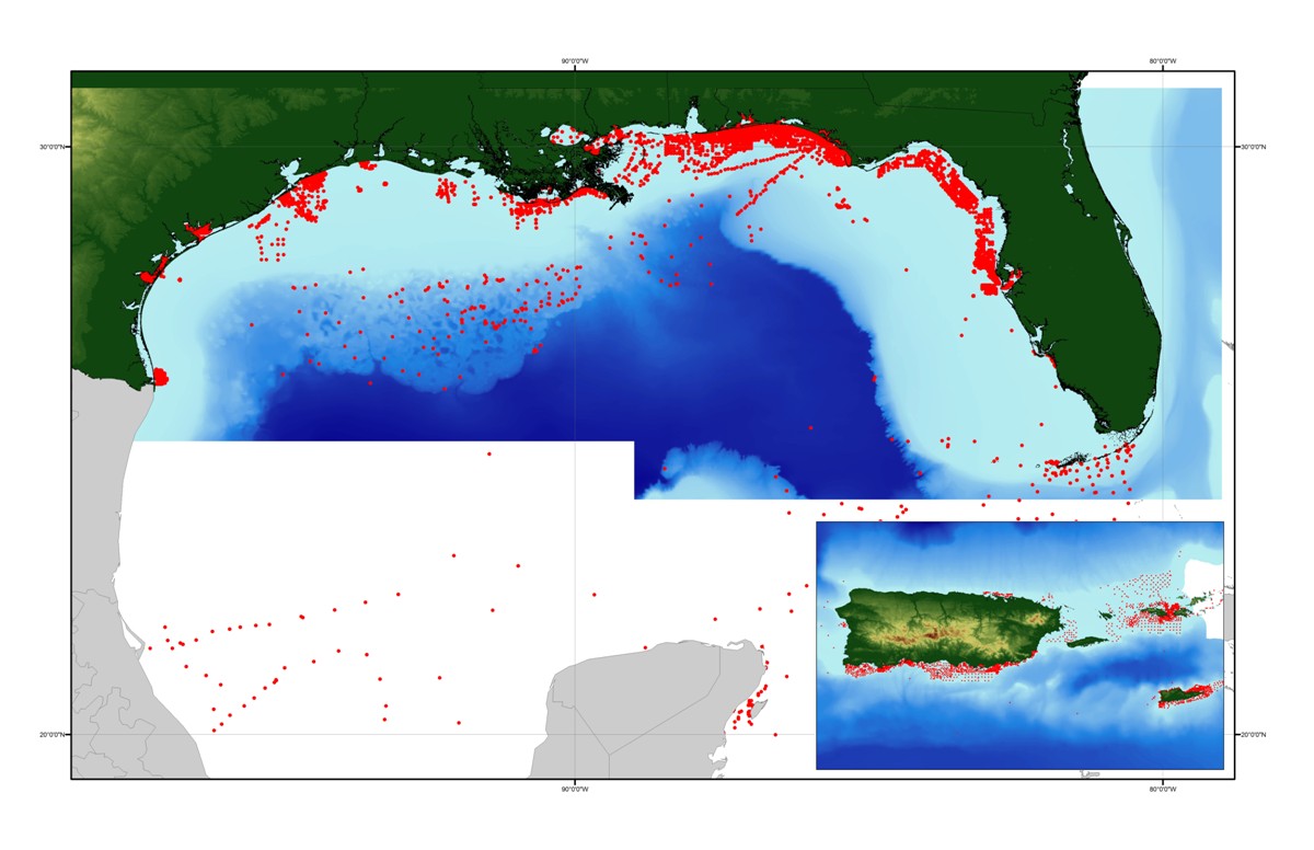
The component data file (_CMP.txt) can be used to investigate the relative presence of various constituents and the development and expression of selected seafloor characteristics.


How was the data set created?

  1. From what previous works were the data drawn?

    Varies with source (source 1 of 1)
    Various, Unpublished and published material, See separate listing, GMX_SRC.txt, and links provided therein, within data publication (see Larger_Work_Citation) for the specific sources and associated metadata.: Various publishers/originators, Various publication places.

    Other_Citation_Details:
    X number of sources, both published and unpublished, are used as the sources of information for usSEABED. Metadata for each source is linked through the usSEABED source file (GMX_SRC.txt). Sources include the U.S. Geological Survey (USGS), the U.S. Army Corps of Engineers (USACE), Minerals Management Service (MMS), National Oceanic and Atmospheric Administration (NOAA), Virginia Institute of Marine Science (VIMS), the Maryland and New Jersey State Geological Surveys (MGS, NJGS), NOAA's National Geophysical Data Center (NGDC), the Smithsonian Institution, and others.
    Type_of_Source_Media: Hard copy and digital
    Source_Contribution:
    Point locations, descriptions, and various analytical data (textural, granulometric, geochemical, geophysical, acoustic) on sediments, rock exposure, and benthos. Varies with source.

  2. How were the data generated, processed, and modified?

    (process 1 of 1)
    Source data may be digitized as necessary (typed or scanned in), with a visual inspection of digitized data to the source report and corrections as necessary, and are tested for completeness in Microsoft Excel as appropriate. Other digital data may be decoded using source-specific programs, downloaded via the web, or sent directly to the USGS or University of Colorado via email. Data are formatted into the dbSEABED Data Entry template (db9_DataEntry.xls, version 08/07/2004) by hand, and tested using the dbSEABED relational database program (RDBi, version 01/05/2006) for correctness of formatting. Data are compiled into source data resource files (DRF) and processed through the dbSEABED data mining program (MNEt, version 04/18/2006) program, using the dbSEABED thesaurus (db9_dct.rtf, version 04/07/2006) and component set up file for U.S. waters (db9_ABUN.txt, version 04/11/2006). Data are iteratively reprocessed and corrected until noted errors are fixed, as recorded by the _RBDS.2fx and _MNE.DGN files. Data are exercised in a GIS for location tests and useability.

    Person who carried out this activity:

    U.S. Geological Survey
    c/o Brian J. Buczkowski
    Core Curator and Data Management Specialist
    Woods Hole Science Centers
    Woods Hole, MA 02543-1598
    USA

    (508) 508-548-8700 x2361 (voice)
    bbuczkowski@usgs.gov

    Contact_Instructions: email preferred
    Data sources produced in this process:
    • GMX_CMP.txt

  3. What similar or related data should the user be aware of?


How reliable are the data; what problems remain in the data set?

  1. How well have the observations been checked?

    Accuracy of each attribute is dependent on the accuracy of the original source description and the values calculated by the mining software, dbSEABED. Values are based on filters using fuzzy set theory and represent a measure of truth about the attribute.

  2. How accurate are the geographic locations?

    Locational accuracy is dependent on both the accuracy of the navigational technique and the level of detail about the location as recorded in the individual data sources, and may vary widely (e.g., from 0.005 km (differential GPS) in the more recent surveys to greater than 2 km based on radar, Loran, or dead reckoning in the older surveys. Users of the data should note the metadata written about the original sources and use their own criteria for assessing the accuracy of the locations.

  3. How accurate are the heights or depths?

    Depth determinations, both water depth and subsample depth, are dependent on the accuracy of the depth determination technique and the level of detail noted in the original source. Users of the data should note the metadata written about the original sources and use their own criteria for assessing the accuracy of the locations.

  4. Where are the gaps in the data? What is missing?

    Additional useable data may exist in this area; the authors appreciate any information and leads.

  5. How consistent are the relationships among the observations, including topology?

    Data in the usSEABED data collection are based on the observations and analyses of others, filtered through a unifying and mining software. Each source report varies in type of information/data recorded and format. Only those observations that are recorded can be filtered and mined; only presence (not absences) of information can be noted.


How can someone get a copy of the data set?

Are there legal restrictions on access or use of the data?

Access_Constraints: None
Use_Constraints:
Public domain data from the U.S. Government are freely redistributable with the proper metadata and source attribution. Please recognize the U.S. Geological Survey (USGS) as the source of this information.

  1. Who distributes the data set? (Distributor 1 of 1)

    U.S. Geological Survey
    c/o Brian J. Buczkowski
    Core Curator and Data Management Specialist
    384 Woods Hole Road
    Woods Hole, MA 02543-1598
    USA

    (508) 548-8700 x2361 (voice)
    (508) 457-2310 (FAX)
    bbuczkowski@usgs.gov

    Contact_Instructions: email preferred
  2. What's the catalog number I need to order this data set?

    Downloadable Data

  3. What legal disclaimers am I supposed to read?

    Although this data set has been used by the U.S. Geological Survey (USGS), no warranty, expressed or implied, is made by the USGS as to the accuracy of the data and/or related materials. The act of distribution shall not constitute any such warranty, and no responsibility is assumed by the USGS in the use of these data or related materials. Trade, firm, or product names and other references to non-USGS products and services are provided for information only and do not constitute endorsement or warranty, express or implied, by the USGS, USDOI, or U.S. Government, as to their suitability, content, usefulness, functioning, completeness, or accuracy.

  4. How can I download or order the data?

  5. What hardware or software do I need in order to use the data set?

    These data are available in Environmental Systems Research Institute (ESRI) shapefile format. The user must have ArcGIS® or ArcView® 3.0 or greater software to read and process the data file. In lieu of ArcView or ArcGIS, the user may utilize another GIS application package capable of importing the data. A free data viewer, arcexplorer, capable of displaying the data is available from ESRI at www.esri.com.


Who wrote the metadata?

Dates:
Last modified: 28-Mar-2006
Metadata author:
Jane A. Reid
U.S. Geological Survey
Geologist
400 Natural Bridges Drive
Santa Cruz, CA 95060

841-427-4727 (voice)
jareid@usgs.gov

Contact_Instructions: email preferred
Metadata standard:
CSDGM Version 2 (FGDC-STD-001-1998)
Metadata extensions used:


Generated by mp version 2.8.6 on Thu Feb 09 14:32:28 2006