Line12: Single Channel Seismic Reflection Result (H. Yokose)
Introduction
In order to identify the boundary between Nuuanu and Wailau landslide deposit
near Oahu and Molokai, single channel seismic reflection surveys were carried
out. Because this study area has a bench like topography in northeast flank
of Oahu at about 4000 mbsl, which is very similar to Hilina landslide area
in their topographic characteristics, it is very interesting to compare
and contrast with the existing detailed Hilina and Nuuanu results. The
boundary is assumed based on the bathymetric map(Moore, 1964) and rock
chemistry (Shinozaki et al., 2002) and is shown with a broken line in figure 1.
Identification of
landslide region corresponding to each event is very important to asses the
scale and to understand the detailed process. During 1998 and 1999 Hawaii
cruise sponsored by JAMSET, precise bathymetric maps for Nuuanu and Wailau
landslides were obtained(Smith et al., 2002).
Purpose
3D
projection of topography based on a precise digital elevation model is very useful
for diversifying the imagination of underwater world . Topographical
characteristics of the study area can be divided into 4 categories:bench like
landslide block, flat plane between megablocks, hummocky terrain, flat basin in
the landslide block. The submarine flat plane between megablocks continu
submarine channel which is start from Oahu or Molokai. Main part of Nuuanu
landslide deposit is topographically
higher than that of Wailau landslide(see Figs. 1 and 2). The boundary line (dot line) assumed previously is not consistent with
topographical nature, such as alignment of landslide blocks and development
of submarine canyon. It is more reasonable that the line move to southeast
as indicated in a heavy solid line in fig. 2.
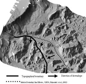 Figure 1
 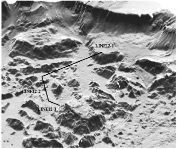 Figure 2
During Leg 1B, we collected single channel seismic reflection data two lines
across boundary zone between Nuuanu and Wailau landslides (line 12-1 and 12-3)
and one line along Wairau landslide(Line 12-2).Initial on-board processing
consisted of bandpass filter (20-100Hz) and scaling. Additional processing was
applied at the University of Hawaii during Leg 2B.
result
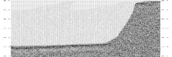
Line
12-1
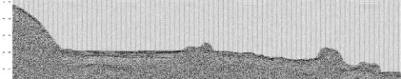
West to East
Line12-1
straddles three different
topographic categories: bench like landslide block, flat plane between
megablocks, hummocky terrain. Because the power of air gun was not sufficient
to penetrate deep subbottom strata, we can not investigate on internal
structure of the bench like megablock and main part of both huge landslide deposits.
We can investigate near ocean floor sedimentary deposits about 500m in their
thickness, where is proximal boundary zone between Nuuanu and Wailau landslide
deposite.
The sedimentary
deposit around Line12-1 can be
divided into four units (unit A:well bedded turbidities
layer, unit B: Hummocky and chaotic sequence, unit C: Chaotic sequence,
unit D: bedrock ). the most upper part of the flat area, which is the western
half of the line is covered
with well bedded turbidity strata which is about 100m thick. Unit
B is a hummocky and chaotic sequence with 200m thick and onlap unit C. Unit B in hummocky terrain was
folded (slumped) and tilted toward
west. This unit did not find in Wailau landslide area and overlay the
landslide block of Wailau landslide unconformly. Unit C, 300-400 m thick, extends
from western side of bench like landslide block to Wailau landslide block.
Line
12-2
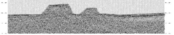
South to North
We
find northern extension of unit B and unit C in southern part of landslide
block on
Line12-2.
Two landslide blocks derived from Wailau landslide sprit unit C into two parts
north and south. Unit C is inferred to be younger than the landslide blocks
based on lack of continuity of
unit C. The flat basin surrounded by landslide blocks dose not have unit
A which is prevailing in both LINE12-1and Line 12-3.
Line
12-3
South to North
In gently dipping ocean bottom plane
from southeastern foot of the Tuscaloosa seamount to Wailau landslide
block stratified sediment (unit A) 300m thick
is imaged and as is interpreted
recent turbidities sequence. Unic B is not observed. Unit C abuts on Tuscaloosa sea mount. Information of under unit C can not
obtained due to insufficient air
gun power.
Conclusion
Although the SCS SYSTEM using in this cruse is not powerful enough to investigate the
internal structure of huge landslide deposit included in megablocks, many
important information about shallow region of the strata were obtained as
follow :
(1)Flat ocean floor
prevailing between landslide blocks is covered with thick (ca. 100m) well
bedded turbidities sequence which is derived from Oahu and Molokai thought
submarine channel.
(2)Unit B is small scale debris avalanche deposit
based on the stratigraphic feature and is younger than Nuuanu and Wailau landslide.