Western Mineral Resources
|
|
|
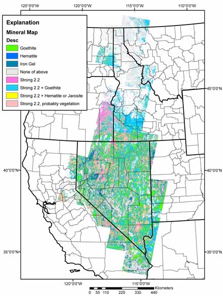
Abstract This report provides mineral distribution maps based on TM spectral information of minerals commonly associated with hydrothermal alteration in Nevada, Idaho, and western Montana. The product of the processing is provided as four ESRI GRID files with 30 m resolution by state. UTM Zone 11 projection is used for Nevada (grid clsnv) and western Idaho (grid clsid), UTM Zone 12 is used for eastern Idaho and western Montana (grid clsid_mt). A fourth grid with a special Albers projection is used for the Headwaters project covering Idaho and western Montana (grid crccls_hs). Symbolization for all four grids is stored in the ESRI layer or LYR files and color or CLR files. Objectives of the analyses were to cover a large area very quickly and to provide data that could be used at a scale of 1:100,000 or smaller. Thus, the image processing was standardized for speed while still achieving the desired 1:100,000-scale level of detail. Consequently, some subtle features of mineralogy may be missed. The hydrothermal alteration data were not field checked to separate mineral occurrences due to hydrothermal alteration from those due to other natural occurrences. The data were evaluated by overlaying the results with 1:100,000 scale topographic maps to confirm correlation with known mineralized areas. The data were also tested in the Battle Mountain area of north-central Nevada by a weights-of-evidence correlation analysis with metallic mineral sites from the USGS Mineral Resources Data System and were found to have significant spatial correlation. On the basis of on these analyses, the data are considered useful for regional studies at scales of 1:100,000. |
Download the text for Data Series 185 as a 14-page PDF file (512 KB)
Download the metadata for the Headwaters project (crccls_hw_metadata.htm; 48 kB)
Download the metadata for Idaho and Montana UTM-12 (clsid_mt_metadata.htm; 48 kB)
Download the metadata for Idaho UTM-11 (clsid_metadata.htm; 48 kB)
Download the metadata for Nevada UTM-11 (clsnv_metadata.htm; 48 kB)
Download the data for the Headwaters project as a compressed file (Headwaters.zip; 26.3 MB compressed file that opens into a 74.1-MB folder)
Download the data for Idaho and Montana UTM-12 as a compressed file (Idaho_Montana_UTM12.zip; 22.9 MB compressed file that opens into a 67.8-MB folder)
Download the data for Idaho UTM-11 as a compressed file (Idaho_UTM11.zip; 31.8 MB compressed file that opens into a 95.3-MB folder)
Download the data for Nevada UTM-11 as a compressed file (Nevada_UTM11.zip; 84.8 MB compressed file that opens into a 302.6-MB folder)
For questions about the content of this report, contact Gary Raines
Download a current version of Adobe Reader for free
| Help
| PDF help
| Western reports main page | Western Data Series reports |
| Geologic
Division | Western Mineral Resources
|
This report is only available online.
Database disclaimer: This database, identified as USGS Data Series 185, has been approved for release and publication by the Director of the USGS. Although this database has been subjected to rigorous review and is substantially complete, the USGS reserves the right to revise the data pursuant to further analysis and review. Furthermore, it is released on condition that neither the USGS nor the United States Government may be held liable for any damages resulting from its authorized or unauthorized use.

![]() U.S. Department of the Interior | U.S. Geological Survey
U.S. Department of the Interior | U.S. Geological Survey
URL: https://pubs.usgs.gov/ds/2006/185/
Page Contact Information: Michael Diggles
Page Last Modified: April 26, 2007