Data Series 189
Published 2006 | ||||||||||||||||||||||||||||||||
| ||||||||||||||||||||||||||||||||
|
||||||||||||||||||||||||||||||||
Abstract |
||||||||||||||||||||||||||||||||
| PRISM3 DOT1 (Pliocene Research, Interpretation and Synoptic Mapping 3, Deep Ocean Temperature 1) provides a three-dimensional temperature reconstruction for the mid-Pliocene Atlantic basin, the first of several regional data sets that will comprise a global mid-Pliocene reconstruction. DOT1 is an alteration of modern temperature values for the Atlantic Ocean in 4°x5° cells in 13 depth layers for December 1 based on Mg/Ca-derived BWT estimates from seventeen DSDP and ODP Sites and SST estimates from the PRISM2 reconstruction (Dowsett and others, 1999). DOT1 reflects a vaguely modern circulation system, assuming similar processes of deep-water formation; however, North Atlantic Deep Water (NADW) production is increased, and Antarctic Bottom Water (AABW) production is decreased. Pliocene NADW was ~2°C warmer than modern temperatures, and Pliocene AABW was ~0.3°C warmer than modern temperatures. | ||||||||||||||||||||||||||||||||
Introduction |
||||||||||||||||||||||||||||||||
The PRISM3 DOT1 Atlantic basin reconstruction is the first of several regional reconstructions that will comprise the PRISM3 global data set. The primary goal of PRISM3 is to create a three-dimensional global data set of mid-Pliocene ocean temperature and salinity that will form the most comprehensive global reconstruction for any warm period prior to the recent past. The data set will be used to drive numerical simulations designed to explore the impact of climate forcings and feedbacks during the mid-Pliocene. PRISM3 is a collaborative data analysis and climate modeling effort in which deep ocean temperature data are generated at Duke University, data analysis and climate reconstructions are achieved at the US Geological Survey, and initial modeling is performed at NASA Goddard Institute for Space Sciences (GISS). Like PRISM2, the PRISM3 DOT1 reconstruction uses a 'time slab' approach to avoid some of the problems associated with point-to-point correlation between core sequences and land sections in this time interval (Dowsett and others, 1999). The PRISM time slab is defined as the interval between the transition of marine oxygen isotope stages M2/M1 and G19/G18 (Shackleton and others, 1995) in the middle part of the Gauss Normal Polarity Chron (C2An). The reconstruction spans the interval of 3.29 Ma to 2.97 Ma (Berggren and others, 1995; Shackleton and others, 1995; Lourens and others, 1996) and ranges from near the bottom of C2An1 (just above Kaena reversed polarity) to within C2An2r (Mammoth reversed polarity). This interval correlates in part to planktonic foraminiferal zones PL3 (Globorotalia margaritae-Sphaeroidinellopsis seminulina Interval Zone), PL4 (Sphaeroidinellopsis seminulina-Dentoglobigerina altispira Interval Zone) and PL5 (Dentoglobigerina altispira-Globorotalia miocenica Interval Zone) of Berggren and others (1995). It falls within calcareous nannofossil zone NN16 of Martini (1971) or CN12a of Bukry (1973, 1975). |
||||||||||||||||||||||||||||||||
Procedures |
||||||||||||||||||||||||||||||||
Layers 1-10, covering 0 m to 1360 m water depth, were altered using a weighted SST anomaly. Because the PRISM2 reconstruction is calibrated to Reynolds and Smith (1995), it was necessary to compute a Pliocene-Modern anomaly prior to altering the LEVITUS_94 modern temperatures. We calculated this anomaly for December 1 by first averaging the November and December PRISM2 2°x2° SST data sets to achieve Pliocene values. We repeated this process with modern Reynolds and Smith 2°x2° SST files to achieve modern December 1 temperature values. Subtraction of the modern values from the Pliocene values yielded a 2°x2° December 1 Pliocene SST anomaly which was converted to a 4°x5° grid. Once converted, no correction was made for sea ice distribution. Finally, we used the following equation to produce Pliocene temperatures for Layers 1-10: Tplio = Tmod + PA where Tmod is the LEVITUS_94 December 1 temperature value in each cell, A is the surface temperature anomaly described above, and P is the weighting function given by: P = 1.2119 – 0.1036 * DEPTH^(0.3393) where DEPTH is the midpoint depth of each layer. Layer 12, basically North Atlantic Deep Water (NADW), was altered by a uniform +2.0°C warming over LEVITUS_94 December 1 conditions. In Layer 13, cells were altered by +0.3°C in the high southern latitudes, +1.3°C near the equator, grading to +2.0°C in the north. Finally, Layer 11 cell values were linearly interpolated between layer 10 and layer 12 estimates. For cells that are land in Layer 12 but water in the above layers, the DOT1 temperatures were calculated as in Layers 1-10, using the Layer 10 weighting factor. Quality control was provided by randomly sampling locations at the surface and comparing the vertical ocean temperature gradients in our reconstructed data (DOT1) to modern temperature gradients (LEVITUS_94) and by reviewing longitudinal profiles through the data. |
||||||||||||||||||||||||||||||||
Rationale |
||||||||||||||||||||||||||||||||
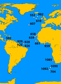
PRISM3 DOT1 reflects a vaguely modern circulation system, assuming similar processes of deep-water formation, though not necessarily in the same locations. Mg/Ca-derived BWT data define three regions of the Atlantic Ocean: North (Sites 982, 552, 610 and 607), Central (Sites 658, 659, 661, 502, 925, 926, 928, 929 and 959) and South (Sites 1085, 1090, 1092 and 704). These data reveal that Pliocene North Atlantic Deep Water (NADW) was ~2°C warmer than modern temperatures and that Pliocene Antarctic Bottom Water (AABW) was ~0.3°C warmer (in the south but mixed and warmed to a greater degree to the north) than modern temperatures. Presently, AABW forms in the Weddell Sea and hugs the sea floor as it moves toward the equator in all ocean basins. NADW is deflected upward by the super-dense AABW at locations not easily defined. These locations would have varied in response to increased or decreased water mass volumes during the Pliocene. DOT1 provides a model in which NADW production is increased and AABW production is decreased. Pliocene NADW formed northward of modern formation and over a larger geographic area. With reduced sea-ice and higher sea-surface temperatures surrounding Antarctica, true Pliocene AABW was smaller in volume and only slightly warmer. DOT1 AABW penetrates to the equator, directed by Antarctic Intermediate Water (AAIW) upwelling at DSDP Site 532 (19.7435° S) where a +2°C anomaly is seen in both seasons. Also, the sill depth at Site 502 (11.4903° N) is 1500-1900 m, and the basin below is filled with AAIW and Upper North Atlantic Deep Water (UNADW). |
||||||||||||||||||||||||||||||||
Data |
||||||||||||||||||||||||||||||||
The PRISM 3 DOT1 Atlantic reconstruction data are presented in a matrix of 44 rows by 24 columns, representing a 4°x5° grid of the Earth. Each cell in the 4°x5° global grid designated as water is given a temperature in degrees Celsius. Cells designated as land are colored gray and are given values of 999. The DOT1 Atlantic reconstruction exists as a Microsoft® Excel file, containing one matrix for each of the 13 ocean layers, arranged as worksheets. The PRISM3 DOT1 Atlantic reconstruction differs from the PRISM2 and PRISM3 MAX and MIN reconstructions in that the data are arranged in a 4°x5° matrix, not a 2°x2° matrix. For questions contact the author, hdowsett@usgs.gov. |
||||||||||||||||||||||||||||||||
Tables |
||||||||||||||||||||||||||||||||
|
||||||||||||||||||||||||||||||||
References |
||||||||||||||||||||||||||||||||
Berggren, W.A., Kent, D.V., Swisher, C.C. and Aubry, M.-P., 1995. A revised Cenozoic geochronology and chronostratigraphy. In Berggren, W.A., Kent, Aubry, M.-P. and Hardenbol, J. eds., Geochronology, time scales and global stratigraphic correlation. Tulsa, Society for sedimentary geology special publication 54: 129-212. Bukry, D., 1973, Low-latitude coccolith biostratigraphic zonation. Initial Reports of the Deep Sea Drilling Project 15: 685-703. Bukry, D. 1975. Coccolith and Silicoflagellate Stratigraphy, Northwestern Pacific Ocean, Deep Sea Drilling Project Leg 32. Initial Reports of the Deep Sea Drilling Project 32: 677-701. Cronin, T.M., Dowsett, H.J., Dwyer, G.S., Baker, P.A. and Chandler, M.A., 2005. Mid-Pliocene deep-sea bottom-water temperatures based on ostracode Mg/Ca ratios. Marine Micropaleontology 54: 249-261. Dowsett, H. J., Barron, J.A, Poore, R.Z., Thompson, R.S., Cronin, T.M., Ishman, S.E. and Willard, D.A., 1999. Middle Pliocene Paleoenvironmental Reconstruction: PRISM2. U.S.Geological Survey Open File Report 99-535, 236 pp. https://pubs.usgs.gov/of/1999/of99-535/. Levitus, S. and Boyer, T.P, 1994. World Ocean Atlas 1994, (Vol. 4): Temperature. NOAA Atlas NESDIS 4. Lourens, L.J., Antonarakou, A., Hilgen, F.J., Van Hoof, A.A.M., Vergnaud- Grazzini, C., and Zachariasse, W.J., 1996. Evaluation of the Plio-Pleistocene astronomical timescale. Paleoceanography 11: 391-413. Martini, E., 1971. Standard tertiary and Quaternary calcareous nannoplankton zonation. In Farinacci, A. (Ed.), Proceedings II Planktonic Conference, Rome, 1970. Telao Scienza, Rome, 2: 739-785. Reynolds, R.W. and Smith, T.M., 1995. A high-resolution global sea surface temperature climatology. Journal of Climatology 8: 1571-1583. Shackleton, N.J., Hall, M.A. and Pate, D., 1995. Pliocene stable isotope stratigraphy of Site 846. Proceedings of the Ocean Drilling Program, Scientific Results 138: 337-355. | ||||||||||||||||||||||||||||||||

![]() U.S. Department of the Interior |
U.S. Geological Survey
U.S. Department of the Interior |
U.S. Geological Survey
URL: https://pubsdata.usgs.gov/pubs/ds/2006/189/index.html
Page Contact Information: Publications Service Center 4
Page Last Modified: 11:54:56 Mon 28 Nov 2016