Data Series 203
Published 2006
1CSC, St. Petersburg, FL 33701.
2U.S. Geological Survey, St. Petersburg, FL 33701.
3Coastal Carolina University, Conway, SC 29528.
Publications are available from USGS Information Services, Box 25286, Federal Center, Denver, CO 80225-0046 (telephone 1-888-ASK-USGS; e-mail: infoservices@usgs.gov).
Table of Contents:Information StatementSystem RequirementsProject SummaryDVD OrganizationGetting StartedAcknowledgmentsReferences Cited |
|
This DVD publication was prepared by an agency of the United States Government. Neither the United States Government nor any agency thereof nor any of their employees makes any warranty, expressed or implied, or assumes any legal liability or responsibility for the accuracy, completeness, or usefulness of any information, apparatus, product, or process disclosed in this report or represents that its use would not infringe privately owned rights. Reference therein to any specific commercial product, process, or service by trade name, trademark, manufacturer, or otherwise does not constitute or imply its endorsement, recommendation, or favoring by the United States Government or any agency thereof.
Although all data and software published on this DVD have been used by the USGS, no warranty, expressed or implied, is made by the USGS as to the accuracy of the data and related materials and (or) the functioning of the software. The act of distribution shall not constitute any such warranty, and no responsibility is assumed by the USGS in the use of these data, software, or related materials.
This DVD disc is readable on any computing platform that has standard DVD driver software installed. The minimum software requirements are a web browser, Acrobat Reader, and a text editor.
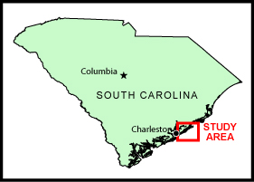
In June of 1997, the U.S. Geological Survey, in cooperation with Coastal Carolina University, conducted a geophysical survey of the shallow geologic framework of the continental shelf offshore of central South Carolina from the Isle of Palms to Bull Island. Data were collected as part of the USGS Coastal Change and Transport (CCT) Project. This report serves as an archive of unprocessed digital boomer seismic reflection data, trackline maps, navigation files, GIS information, observers' logbooks, Field Activity Collection System (FACS) logs, and formal FGDC metadata. Filtered and gained digital images of the seismic profiles are also provided. Refer to the Acronyms page for expansion of all acronyms and abbreviations used in this report.
The archived trace data are in standard Society of Exploration Geophysicists (SEG) SEG-Y format (Barry and others, 1975) and may be downloaded and processed with commercial or public domain software such as Seismic Unix (SU). Example SU processing scripts and USGS software for viewing the SEG-Y files (Zihlman, 1992) are also provided. Note: The web version of this archive does not contain the SEG-Y trace files. These files are very large and would require extremely long download times. To obtain the complete DVD archive, contact USGS Information at 1-888-ASK-USGS or infoservices@usgs.gov.
The USGS Florida Integrated Science Center (FISC) - St. Petersburg assigns a unique identifier to each cruise or field activity. For example, 97CCT01 tells us the data were collected in 1997 for the Coastal Change and Transport (CCT) Project and the data were collected during the first field activity for that project in that calendar year. Refer to http://walrus.wr.usgs.gov/infobank/programs/html/definition/activity.html for a detailed description of the method used to assign the cruise ID. To differentiate between lines collected on different days, the date was added to the beginning of each trackline name. For example, line SB_1 collected on June 1 became line 601_SB_1, and line SB_1 collected on June 2 became line 602_SB_1.
The boomer plate is an acoustic energy source that consists of capacitors charged to a high voltage and discharged through a transducer in the water. The transducer is towed on a sled at the sea surface and when discharged emits a short acoustic pulse, or shot, that propagates through the water and sediment column. The acoustic energy is reflected at density boundaries (such as the seafloor or sediment layers beneath the seafloor), detected by the receiver, and recorded by a PC-based seismic acquisition system. This process is repeated at timed intervals (e.g., 0.5 s) and recorded for specific intervals of time (e.g., 100 ms). In this way, a two-dimensional vertical image of the shallow geologic structure beneath the ship track is produced. Figure 1 displays acquisition geometry for this cruise, and table 1 is a summary of acquisition parameters. Refer to the FACS equipment log (13 KB) for details about the acquisition equipment used. Scanned images of all handwritten logbooks (operations.pdf [1.8 MB] and science.pdf [1.2 MB]) are also provided as PDF files.
The unprocessed seismic data are stored in SEG-Y format (Barry and others, 1975). For a detailed description of the data format, refer to the SEG-Y Format page. See the How To Download SEG-Y Data page for download instructions. Note: The web version of this archive does not contain the SEG-Y trace files. These files are very large and would require extremely long download times. To obtain the complete DVD archive, contact USGS Information at 1-888-ASK-USGS or infoservices@usgs.gov. Processed profiles are GIF images that can be viewed from the Profiles page. Refer to the Software page for details about the processing and examples of the processing scripts.
Detailed information about the navigation system used can be found in table 1 and the FACS equipment log (13 KB). To view the trackline maps and navigation files, and for more information about these items, see the Navigation page. Navigation is missing for the first 115 shots of line 604_SB_1. On the trackline maps, a cross marks the location of the first available navigation fix for this line. Navigation is also intermittent for line 602_SB_1. On the trackline maps, the location of missing navigation data within a line is inferred by linear interpolation of the first and last known data points and is indicated by a dashed yellow line.
Sidescan sonar data were collected concurrently with seismic tracklines 603_SB_1 to 604_SB_5. Refer to the logbooks (operations.pdf [1.8 MB] and science.pdf [1.2 MB]) and FACS (crew.pdf [11.6 KB], equipment.pdf [12.6 KB], overview.pdf [15 KB]) forms for more information about these data and the equipment used.
The Disc Contents page is a diagram of the location of all files and folders contained on this disc and provides links to these files and folders.
To access the information contained on this disc, use a web browser to open the file index.html. This report is divided into five sections: Navigation Data and Maps, Seismic Profiles, Field Activity Logs, Metadata, and Software. Links at the top and bottom of each page provide access to these sections. This report contains links to the USGS and collaborators or other resources that are only accessible if access to the Internet is available while viewing these documents.
Funding and/or support for this study was provided by the USGS Coastal and Marine Geology Program and Coastal Carolina University. We thank R/V G.K. Gilbert captain Keith A. Ludwig of the USGS in St. Petersburg, Florida, for his assistance in data collection. This document was improved by the reviews of Kathryn E.L. Smith (USGS) and Noreen A. Buster (ETI Professionals, Inc., contracted by the USGS) at the FISC - St. Petersburg, Florida.
Barry, R.M., Cavers, D.A., and Kneale, C.W., 1975, Recommended standards for digital tape formats: Geophysics, v. 40, p. 344-352. Also available online at: http://www.seg.org/publications/tech-stand.
Zihlman, F.N., 1992, DUMPSEGY V1.0: A program to examine the contents of SEG-Y disk-image seismic data: U.S. Geological Survey Open-File Report 92-590, 28 p.

![]() U.S. Department of the Interior |
U.S. Geological Survey
U.S. Department of the Interior |
U.S. Geological Survey
URL: pubsdata.usgs.gov /pubs/ds/2006/203/index.html
Page Contact Information: Publishing Services
Page Last Modified: Monday, 28-Nov-2016 12:04:38 EST

