Data Series 224
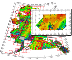
USGS Data Series Report for the release of aeromagnetic data collected in the Taylor Mountains Area of Southwest Alaska and associated contractor reports. SummaryAn airborne high-resolution magnetic and coincidental horizontal magnetic gradiometer survey was completed over the Taylor Mountains area in southwest Alaska. The flying was undertaken by McPhar Geosurveys Ltd. on behalf of the United States Geological Survey (USGS). First tests and calibration flights were completed by April 7, 2004, and data acquisition was initiated on April 17, 2004. The final data acquisition and final test/calibrations flight was completed on May 31, 2004. Data acquired during the survey totaled 8,971.15 line-miles.
|
Version 1.0 Posted November 2006 |
Part or all of this report is presented in Portable Document Format (PDF); the latest version of Adobe Acrobat Reader or similar software is required to view it. Download the latest version of Acrobat Reader, free of charge or go to access.adobe.com for free tools that allow visually impaired users to read PDF files.
