Western Coastal and Marine Geology
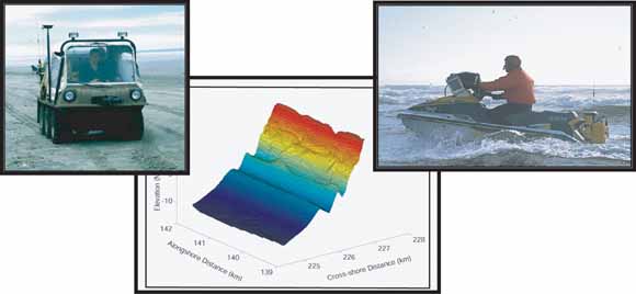
This report describes methods used, data collected, and results of the Beach Morphology Monitoring Program in the Columbia River Littoral Cell (CRLC) from 1997 to 2005. A collaborative group primarily consisting of the US Geological Survey and the Washington State Department of Ecology performed this work. Beach Monitoring efforts consisted of collecting topographic and bathymetric horizontal and vertical position data using a Real Time Kinematic Differential Global Positioning System (RTK-DGPS). Sediment size distribution data was also collected as part of this effort. The monitoring program was designed to: 1) quantify the short- to medium-term (seasonal to interannual) beach change rates and morphological variability along the CRLC and assess the processes responsible for these changes; 2) collect beach state data (i.e., grain size, beach slope, and dune/sandbar height/position) to enhance the conceptual understanding of CRLC functioning and refine predictions of future coastal change and hazards; 3) compare and contrast the scales of environmental forcing and beach morphodynamics in the CRLC to other coastlines of the world; and 4) provide beach change data in a useful format to land use managers.
Download this report as an 88-page PDF document (ds260.pdf; 6.5 MB)
Go to the Metadata folder (8.9 MB)
Go to the Geodetic Control folder (1.5 MB)
Go to the Nearshore Bathymetry folder (297 MB)
Go to the Sediment Size Distributions folder (512 kB)
Go to the Shoreline Change Reference Features folder (1 MB)
Go to the Topographic Beach Profiles folder (60.3 MB)
Go to the Topographic Beach Surface Maps folder (98.9 MB)
Go to the Waves And Water Levels folder (37.7 MB)
For questions about the content of this report, contact Peter Ruggiero
Suggested citation and version history
Download a copy of the latest version of Adobe Reader for free.
| Help
| PDF help
| Publications main page | Western Data Series reports |
| Geologic Division |
Western Coastal and Marine Geology
|

![]() U.S. Department of the Interior | U.S. Geological Survey
U.S. Department of the Interior | U.S. Geological Survey
URL: https://pubs.usgs.gov/ds/2007/260/
Page Contact Information: Michael Diggles
Page Last Modified: January 28, 2008