![[Link to USGS home page]](site/volcban2.gif)
INTRODUCTION |
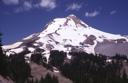 Mount Hood Volcano, the highest peak in Oregon (11,239 ft; 3,426 m), as seen from the Mount Hood Meadows Ski Area, located approximately 5 km (3 miles) south-southeast of its summit. The most recent eruption of this chiefly andesitic volcano was about 200 years ago. (Photograph by Robert I. Tilling.) |
| DATA |
|
| PLOTFILES |
|
| LINKS |
U.S. Department of the Interior
U.S. Geological Survey
For questions about the content of this report, contact Dave Ramsey
Suggested citation and version history
Download a free copy of the latest version of Adobe Reader.
|
Help |
PDF help |
Publications main page |
| Western Data-Series reports |
| Geology | Volcano Hazards Program
|
This report is also available in printed form as USGS Geologic Investigations Series I-2569. This database is also available as USGS Data Series 313 on CD-ROM. Obtain either by contacting:
USGS Information Services
Box 25286, Federal Center
Denver, CO 80225
Telephone: 1-888-ASK-USGS
E-mail: infoservices@usgs.gov

![]() U.S. Department of the Interior | U.S. Geological Survey
U.S. Department of the Interior | U.S. Geological Survey
URL: https://pubs.usgs.gov/ds/313/
Page Contact Information: Michael Diggles
Page Created: October 17, 2008
Page Last Modified: October 28, 2008
(mfd)